Bridge Statistics for Clancy, Montana (MT)
Condition, Traffic, Stress, Structural Evaluation, Project Costs
- National Bridge Inventory (NBI) Statistics
- 17Number of bridges
- 75ft / 22.9mTotal length
- 36,627Total average daily traffic
- 4,997Total average daily truck traffic
- National Bridge Inventory (NBI) Registered Bridges for Clancy
- No street view available for this location
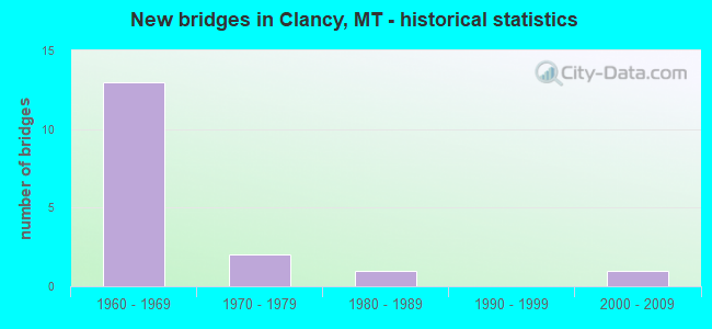
- New bridges - historical statistics
- 131960-1969
- 21970-1979
- 11980-1989
- 12000-2009


- Bridge Condition - Deck
- 27.3%Good
- 18.2%Satisfactory
- 54.5%Fair

- Bridge Condition - Superstructure
- 27.3%Good
- 36.4%Satisfactory
- 36.4%Fair

- Bridge Condition - Substructure
- 63.6%Good
- 18.2%Satisfactory
- 18.2%Fair

- Bridge Condition - Channel
- 57.1%Very good
- 42.9%Good
Find on map >> Show street view
Structure Number: 7044, Location: 2.3 S MONTANA CITY (Lat: 46.511817, Lng: -111.948558), Route carried "on" structure: State highway 282, Year Built: 1969, Status: Open, Structure Length: 1.00m (3.28ft), Average Daily Traffic: 2,057 (year 2020), Truck Traffic: 1%, Average Future Daily Traffic: 2,160 (year 2040), Design Load: HS 20, Features Intersected: PRICKLY PEAR CREEK
Minimum Vertical Clearance: 30+ m (98+ ft), Kilometerpoint: 3.581, Lanes on structure: 2, Owner: State Highway Agency, Approaching Roadway Width: 7.8m (25.6ft), Skew: 2 degrees, Material/Design: Steel, Design/Construction: Culvert, Number Of Spans In Main Unit: 2, Length of Maximum Span: 4.3m (14.1ft)
Condition: Channel: Very good, Culverts: Poor, Structural Evaluation: Meets minimum limits, Waterway Adequacy: Equal to present minimum criteria, Approach Roadway Alignment: Meets minimum limits, Designated Inspection Frequency: Every 24 months, Inspection Date: January 2021
Find on map >> Show street view
Structure Number: 7075, Location: 3M S MONTANA CITY (Lat: 46.501475, Lng: -111.952600), Route carried "on" structure: State highway 282, Year Built: 1981, Status: Open, Structure Length: 1.68m (5.51ft), Average Daily Traffic: 888 (year 2020), Truck Traffic: 3%, Average Future Daily Traffic: 932 (year 2040), Features Intersected: PRICKLY PEAR CREEK
Minimum Vertical Clearance: 30+ m (98+ ft), Kilometerpoint: 4.791, Lanes on structure: 2, Owner: State Highway Agency, Approaching Roadway Width: 7.9m (25.9ft), Skew: 2 degrees, Material/Design: Concrete, Design/Construction: Tee Beam, Number Of Spans In Main Unit: 1, Length of Maximum Span: 16.5m (54.1ft), Curb-To-Curb Width: 8.5m (27.9ft), Out-to-Out Width: 9.1m (29.9ft)
Condition: Deck: Good, Superstructure: Good, Substructure: Good, Channel: Very good, Operating Rating: 32.7 metric tons, Method Used To Determine Operating Rating: Field evaluation and documented engineering judgment, Inventory Rating: 32.7 metric tons, Method Used To Determine Inventory Rating: Field evaluation and documented engineering judgment, Structural Evaluation: Better than present minimum criteria, Deck Geometry: Somewhat better than minimum adequacy, Waterway Adequacy: Equal to present desirable criteria, Approach Roadway Alignment: Equal to present minimum criteria, Designated Inspection Frequency: Every 24 months, Inspection Date: July 2020, Deck Structure Type: Concrete Precast Panels, Wearing Surface/Protective System: Wearing Surface: Bituminous
Find on map >> Show street view
Structure Number: I00015180+08901, Location: 1.2M S CLANCY (Lat: 46.450869, Lng: -111.986667), Route carried "on" structure: Interstate 15, Year Built: 1969, Status: Open, Structure Length: 0.69m (2.26ft), Average Daily Traffic: 5,820 (year 2020), Truck Traffic: 17%, Average Future Daily Traffic: 6,431 (year 2040), Design Load: HS 20, Features Intersected: PRICKLY PEAR CREEK
Minimum Vertical Clearance: 30+ m (98+ ft), Kilometerpoint: 290.461, Lanes on structure: 4, Base Highway Network: Yes, Owner: State Highway Agency, Approaching Roadway Width: 23.2m (76.1ft), Skew: 1 degrees, Material/Design: Concrete, Design/Construction: Slab, Number Of Spans In Main Unit: 1, Length of Maximum Span: 6.3m (20.7ft), Curb-To-Curb Width: 21.9m (71.9ft), Out-to-Out Width: 35.7m (117.1ft)
Condition: Deck: Satisfactory, Superstructure: Satisfactory, Substructure: Fair, Channel: Good, Operating Rating: 68.9 metric tons, Method Used To Determine Operating Rating: Load Factor (LF), Inventory Rating: 41.7 metric tons, Method Used To Determine Inventory Rating: Load Factor (LF), Structural Evaluation: Somewhat better than minimum adequacy, Deck Geometry: Better than present minimum criteria, Waterway Adequacy: Better than present minimum criteria, Approach Roadway Alignment: Equal to present desirable criteria, Designated Inspection Frequency: Every 24 months, Inspection Date: January 2021, Deck Structure Type: Concrete Cast-file-Place, Wearing Surface/Protective System: Wearing Surface: Bituminous
Find on map >> Show street view
Structure Number: I00015181+05641, Location: 0.6M S CLANCY (Lat: 46.460697, Lng: -111.984058), Route carried "on" structure: Interstate 15, Year Built: 1969, Status: Open, Structure Length: 0.69m (2.26ft), Average Daily Traffic: 5,820 (year 2020), Truck Traffic: 17%, Average Future Daily Traffic: 6,431 (year 2040), Design Load: HS 20, Features Intersected: PRICKLY PEAR CREEK
Minimum Vertical Clearance: 30+ m (98+ ft), Kilometerpoint: 291.571, Lanes on structure: 4, Base Highway Network: Yes, Owner: State Highway Agency, Approaching Roadway Width: 23.2m (76.1ft), Skew: 1 degrees, Material/Design: Concrete, Design/Construction: Slab, Number Of Spans In Main Unit: 1, Length of Maximum Span: 6.3m (20.7ft), Curb-To-Curb Width: 23.2m (76.1ft), Out-to-Out Width: 35.7m (117.1ft)
Condition: Deck: Fair, Superstructure: Fair, Substructure: Fair, Channel: Good, Operating Rating: 68.9 metric tons, Method Used To Determine Operating Rating: Load Factor (LF), Inventory Rating: 40.8 metric tons, Method Used To Determine Inventory Rating: Load Factor (LF), Structural Evaluation: Somewhat better than minimum adequacy, Deck Geometry: Superior to present desirable criteria, Waterway Adequacy: Better than present minimum criteria, Approach Roadway Alignment: Equal to present desirable criteria, Designated Inspection Frequency: Every 24 months, Inspection Date: January 2021, Deck Structure Type: Concrete Cast-file-Place, Wearing Surface/Protective System: Wearing Surface: Bituminous
Find on map >> Show street view
Structure Number: I00015182+01161, Location: CLANCY (Lat: 46.468361, Lng: -111.981497), Route carried "on" structure: Interstate 15, Year Built: 1969, Status: Open, Structure Length: 3.63m (11.91ft), Average Daily Traffic: 100 (year 2022), Truck Traffic: 3%, Average Future Daily Traffic: 100 (year 2037), Design Load: HS 20, Features Intersected: INT CLANCY
Minimum Vertical Clearance: 30+ m (98+ ft), Kilometerpoint: 292.217, Lanes on structure: 2, Lanes under structure: 2, Base Highway Network: Yes, Owner: State Highway Agency, Approaching Roadway Width: 11.5m (37.7ft), Material/Design: Prestressed concrete, Design/Construction: Stringer/Multi-beam, Number Of Spans In Main Unit: 3, Length of Maximum Span: 14.3m (46.9ft), Curb or Sidewalk Widths: Left: 0.1m (0.3ft), Right: 0.1m (0.3ft), Curb-To-Curb Width: 11.6m (38.1ft), Out-to-Out Width: 12.4m (40.7ft)
Condition: Deck: Fair, Superstructure: Satisfactory, Substructure: Good, Operating Rating: 50.8 metric tons, Method Used To Determine Operating Rating: Load and Resistance Factor (LRFR), Inventory Rating: 39.0 metric tons, Method Used To Determine Inventory Rating: Load and Resistance Factor (LRFR), Structural Evaluation: Equal to present minimum criteria, Deck Geometry: Equal to present minimum criteria, Underclear: Meets minimum limits, Approach Roadway Alignment: Equal to present desirable criteria, Designated Inspection Frequency: Every 24 months, Inspection Date: November 2021, Deck Structure Type: Concrete Cast-file-Place, Wearing Surface/Protective System: Membrane: Epoxy
Find on map >> Show street view
Structure Number: I00015182+01162, Location: CLANCY (Lat: 46.468422, Lng: -111.981797), Route carried "on" structure: Interstate 15, Year Built: 1969, Status: Open, Structure Length: 3.63m (11.91ft), Average Daily Traffic: 100 (year 2022), Truck Traffic: 3%, Average Future Daily Traffic: 100 (year 2037), Design Load: HS 20, Features Intersected: INT CLANCY
Minimum Vertical Clearance: 30+ m (98+ ft), Kilometerpoint: 292.012, Lanes on structure: 2, Lanes under structure: 2, Base Highway Network: Yes, Owner: State Highway Agency, Approaching Roadway Width: 11.5m (37.7ft), Material/Design: Prestressed concrete, Design/Construction: Stringer/Multi-beam, Number Of Spans In Main Unit: 3, Length of Maximum Span: 14.3m (46.9ft), Curb or Sidewalk Widths: Left: 0.1m (0.3ft), Right: 0.1m (0.3ft), Curb-To-Curb Width: 11.6m (38.1ft), Out-to-Out Width: 12.4m (40.7ft)
Condition: Deck: Satisfactory, Superstructure: Good, Substructure: Good, Operating Rating: 50.8 metric tons, Method Used To Determine Operating Rating: Load and Resistance Factor (LRFR), Inventory Rating: 39.0 metric tons, Method Used To Determine Inventory Rating: Load and Resistance Factor (LRFR), Structural Evaluation: Better than present minimum criteria, Deck Geometry: Equal to present minimum criteria, Underclear: Meets minimum limits, Approach Roadway Alignment: Equal to present desirable criteria, Designated Inspection Frequency: Every 24 months, Inspection Date: November 2021, Deck Structure Type: Concrete Cast-file-Place, Wearing Surface/Protective System: Membrane: Epoxy
Find on map >> Show street view
Structure Number: I00015182+07381, Location: 0.6M N CLANCY (Lat: 46.477022, Lng: -111.977975), Route carried "on" structure: Interstate 15, Year Built: 1969, Status: Open, Structure Length: 2.44m (8.01ft), Average Daily Traffic: 7,014 (year 2020), Truck Traffic: 14%, Average Future Daily Traffic: 7,750 (year 2040), Design Load: HS 20, Features Intersected: SEP LUMP GULCH ROAD
Minimum Vertical Clearance: 30+ m (98+ ft), Kilometerpoint: 293.445, Lanes on structure: 2, Lanes under structure: 2, Base Highway Network: Yes, Owner: State Highway Agency, Approaching Roadway Width: 11.6m (38.1ft), Material/Design: Concrete continuous, Design/Construction: Slab, Number Of Spans In Main Unit: 3, Length of Maximum Span: 9.1m (29.9ft), Curb or Sidewalk Widths: Left: 0.1m (0.3ft), Right: 0.1m (0.3ft), Curb-To-Curb Width: 11.6m (38.1ft), Out-to-Out Width: 12.4m (40.7ft)
Condition: Deck: Fair, Superstructure: Fair, Substructure: Satisfactory, Operating Rating: 58.1 metric tons, Method Used To Determine Operating Rating: Load Factor (LF), Inventory Rating: 35.4 metric tons, Method Used To Determine Inventory Rating: Load Factor (LF), Structural Evaluation: Somewhat better than minimum adequacy, Deck Geometry: Equal to present minimum criteria, Underclear: High priority of corrective action, Approach Roadway Alignment: Equal to present desirable criteria, Designated Inspection Frequency: Every 24 months, Inspection Date: March 2020, Deck Structure Type: Concrete Cast-file-Place, Wearing Surface/Protective System: Wearing Surface: Latex Concrete
Find on map >> Show street view
Structure Number: I00015182+07382, Location: 0.6M N CLANCY (Lat: 46.477111, Lng: -111.978231), Route carried "on" structure: Interstate 15, Year Built: 1969, Status: Open, Structure Length: 2.38m (7.81ft), Average Daily Traffic: 7,014 (year 2020), Truck Traffic: 14%, Average Future Daily Traffic: 7,750 (year 2040), Design Load: HS 20, Features Intersected: SEP LUMP GULCH ROAD
Minimum Vertical Clearance: 30+ m (98+ ft), Kilometerpoint: 293.205, Lanes on structure: 2, Lanes under structure: 2, Base Highway Network: Yes, Owner: State Highway Agency, Approaching Roadway Width: 11.6m (38.1ft), Material/Design: Concrete continuous, Design/Construction: Slab, Number Of Spans In Main Unit: 3, Length of Maximum Span: 9.3m (30.5ft), Curb or Sidewalk Widths: Left: 0.1m (0.3ft), Right: 0.1m (0.3ft), Curb-To-Curb Width: 11.6m (38.1ft), Out-to-Out Width: 12.2m (40.0ft)
Condition: Deck: Fair, Superstructure: Fair, Substructure: Satisfactory, Operating Rating: 58.1 metric tons, Method Used To Determine Operating Rating: Load Factor (LF), Inventory Rating: 35.4 metric tons, Method Used To Determine Inventory Rating: Load Factor (LF), Structural Evaluation: Somewhat better than minimum adequacy, Deck Geometry: Equal to present minimum criteria, Underclear: Meets minimum limits, Approach Roadway Alignment: Equal to present desirable criteria, Designated Inspection Frequency: Every 24 months, Inspection Date: March 2020, Deck Structure Type: Concrete Cast-file-Place, Wearing Surface/Protective System: Wearing Surface: Latex Concrete
Find on map >> Show street view
Structure Number: I00015185+05792, Location: 1.9M S MONTANA CITY (Lat: 46.511547, Lng: -111.948100), Route carried "on" structure: Interstate 15, Year Built: 1968, Status: Open, Structure Length: 4.11m (13.48ft), Average Daily Traffic: 7,014 (year 2020), Truck Traffic: 14%, Average Future Daily Traffic: 7,750 (year 2040), Design Load: HS 20, Features Intersected: SEP S HWY 282
Minimum Vertical Clearance: 30+ m (98+ ft), Kilometerpoint: 297.775, Lanes on structure: 2, Lanes under structure: 2, Base Highway Network: Yes, Owner: State Highway Agency, Approaching Roadway Width: 11.6m (38.1ft), Skew: 2 degrees, Material/Design: Prestressed concrete, Design/Construction: Stringer/Multi-beam, Number Of Spans In Main Unit: 3, Length of Maximum Span: 15.7m (51.5ft), Curb-To-Curb Width: 11.6m (38.1ft), Out-to-Out Width: 12.5m (41.0ft)
Condition: Deck: Fair, Superstructure: Satisfactory, Substructure: Good, Operating Rating: 50.8 metric tons, Method Used To Determine Operating Rating: Load and Resistance Factor (LRFR), Inventory Rating: 34.5 metric tons, Method Used To Determine Inventory Rating: Load and Resistance Factor (LRFR), Structural Evaluation: Equal to present minimum criteria, Deck Geometry: Equal to present minimum criteria, Underclear: Somewhat better than minimum adequacy, Approach Roadway Alignment: Equal to present desirable criteria, Designated Inspection Frequency: Every 24 months, Inspection Date: March 2020, Deck Structure Type: Concrete Cast-file-Place, Wearing Surface/Protective System: Wearing Surface: Monolithic Concrete, Membrane: Epoxy
Find on map >> Show street view
Structure Number: L22032001+00001, Location: 1M N CLANCY (Lat: 46.477511, Lng: -111.981075), Route carried "on" structure: County highway 22032, Year Built: 2007, Status: Open, Structure Length: 1.25m (4.10ft), Average Daily Traffic: 100 (year 2022), Truck Traffic: 3%, Average Future Daily Traffic: 100 (year 2037), Design Load: HS 20, Features Intersected: PRICKLY PEAR CREEK 074, Facility Carried by Structure: LUMP GULCH ROAD
Minimum Vertical Clearance: 30+ m (98+ ft), Kilometerpoint: 0.198, Lanes on structure: 2, Owner: County Highway Agency, Approaching Roadway Width: 8.0m (26.2ft), Material/Design: Prestressed concrete, Design/Construction: Tee Beam, Number Of Spans In Main Unit: 1, Length of Maximum Span: 12.5m (41.0ft), Curb-To-Curb Width: 7.6m (24.9ft), Out-to-Out Width: 7.9m (25.9ft)
Condition: Deck: Good, Superstructure: Good, Substructure: Good, Channel: Good, Operating Rating: 68.8 metric tons, Method Used To Determine Operating Rating: Load Factor (LF), Inventory Rating: 41.2 metric tons, Method Used To Determine Inventory Rating: Load Factor (LF), Structural Evaluation: Better than present minimum criteria, Deck Geometry: Equal to present minimum criteria, Waterway Adequacy: Equal to present desirable criteria, Approach Roadway Alignment: Equal to present desirable criteria, Designated Inspection Frequency: Every 24 months, Inspection Date: January 2022, Deck Structure Type: Other
Find on map >> Show street view
Structure Number: L22033000+02001, Location: CLANCY (Lat: 46.468686, Lng: -111.983186), Route carried "on" structure: County highway 22033, Year Built: 1976, Status: Open, Structure Length: 0.67m (2.20ft), Average Daily Traffic: 100 (year 2022), Truck Traffic: 3%, Average Future Daily Traffic: 100 (year 2037), Features Intersected: PRICKLY PEAR CREEK 070, Facility Carried by Structure: LEGAL TENDER LN
Minimum Vertical Clearance: 30+ m (98+ ft), Kilometerpoint: 0.172, Lanes on structure: 2, Owner: County Highway Agency, Approaching Roadway Width: 7.3m (24.0ft), Material/Design: Concrete, Design/Construction: Tee Beam, Number Of Spans In Main Unit: 1, Length of Maximum Span: 6.1m (20.0ft), Curb or Sidewalk Widths: Left: 0.2m (0.7ft), Right: 0.2m (0.7ft), Curb-To-Curb Width: 7.3m (24.0ft), Out-to-Out Width: 7.8m (25.6ft)
Condition: Deck: Good, Superstructure: Fair, Substructure: Good, Channel: Very good, Operating Rating: 54.4 metric tons, Method Used To Determine Operating Rating: Field evaluation and documented engineering judgment, Inventory Rating: 32.7 metric tons, Method Used To Determine Inventory Rating: Field evaluation and documented engineering judgment, Structural Evaluation: Somewhat better than minimum adequacy, Deck Geometry: Equal to present minimum criteria, Waterway Adequacy: Equal to present desirable criteria, Approach Roadway Alignment: Equal to present desirable criteria, Designated Inspection Frequency: Every 24 months, Inspection Date: January 2021, Deck Structure Type: Other, Wearing Surface/Protective System: Wearing Surface: Bituminous
Find on map >> Show street view
Structure Number: L22195000+09001, Location: CLANCY (Lat: 46.467325, Lng: -111.983361), Route carried "on" structure: State highway 22195, Year Built: 1976, Status: Open, Structure Length: 0.78m (2.56ft), Average Daily Traffic: 100 (year 2022), Truck Traffic: 3%, Average Future Daily Traffic: 100 (year 2037), Features Intersected: PRICKLY PEAR CREEK 065, Facility Carried by Structure: RAILROAD WAY
Minimum Vertical Clearance: 30+ m (98+ ft), Kilometerpoint: 0.324, Lanes on structure: 2, Owner: State Highway Agency, Approaching Roadway Width: 9.5m (31.2ft), Material/Design: Concrete, Design/Construction: Slab, Number Of Spans In Main Unit: 1, Length of Maximum Span: 7.0m (23.0ft), Curb-To-Curb Width: 7.3m (24.0ft), Out-to-Out Width: 10.1m (33.1ft)
Condition: Deck: Fair, Superstructure: Satisfactory, Substructure: Good, Channel: Very good, Operating Rating: 54.4 metric tons, Method Used To Determine Operating Rating: Field evaluation and documented engineering judgment, Inventory Rating: 32.7 metric tons, Method Used To Determine Inventory Rating: Field evaluation and documented engineering judgment, Structural Evaluation: Equal to present minimum criteria, Deck Geometry: Equal to present minimum criteria, Waterway Adequacy: Better than present minimum criteria, Approach Roadway Alignment: Equal to present desirable criteria, Designated Inspection Frequency: Every 24 months, Inspection Date: January 2022, Deck Structure Type: Concrete Cast-file-Place
Find on map >> Show street view
Structure Number: I00015182+01161, Location: CLANCY (Lat: 46.468361, Lng: -111.981497), Route carried "under" structure: ServiceCounty highway 22195, Year Built: 1969, Structure Length: 0. m, Average Daily Traffic: 100 (year 2022), Truck Traffic: 3%, Features Intersected: INT CLANCY, Facility Carried by Structure: I 15
Minimum Vertical Clearance: 4.88m (16.01ft), Kilometerpoint: 0.059, Lanes on structure: 2, Lanes under structure: 2, Material/Design: Prestressed concrete, Design/Construction: Stringer/Multi-beam, Length of Maximum Span: 14.3m (46.9ft)
Find on map >> Show street view
Structure Number: I00015182+01162, Location: CLANCY (Lat: 46.468422, Lng: -111.981797), Route carried "under" structure: ServiceCounty highway 22195, Year Built: 1969, Structure Length: 0. m, Average Daily Traffic: 100 (year 2022), Truck Traffic: 3%, Features Intersected: INT CLANCY, Facility Carried by Structure: I 15
Minimum Vertical Clearance: 4.88m (16.01ft), Kilometerpoint: 0.085, Lanes on structure: 2, Lanes under structure: 2, Material/Design: Prestressed concrete, Design/Construction: Stringer/Multi-beam, Length of Maximum Span: 14.3m (46.9ft)
Find on map >> Show street view
Structure Number: I00015182+07381, Location: 06M N CLANCY (Lat: 46.477022, Lng: -111.977975), Route carried "under" structure: ServiceCounty highway 22929, Year Built: 1969, Structure Length: 0. m, Average Daily Traffic: 100 (year 2022), Truck Traffic: 3%, Features Intersected: SEP LUMP GULCH ROAD, Facility Carried by Structure: I 15
Minimum Vertical Clearance: 4.52m (14.83ft), Kilometerpoint: 0.031, Lanes on structure: 2, Lanes under structure: 2, Material/Design: Concrete continuous, Design/Construction: Slab, Length of Maximum Span: 9.1m (29.9ft)
Find on map >> Show street view
Structure Number: I00015182+07382, Location: 06M N CLANCY (Lat: 46.477111, Lng: -111.978231), Route carried "under" structure: ServiceCounty highway 22929, Year Built: 1969, Structure Length: 0. m, Average Daily Traffic: 100 (year 2022), Truck Traffic: 3%, Features Intersected: SEP LUMP GULCH ROAD, Facility Carried by Structure: I 15
Minimum Vertical Clearance: 5.05m (16.57ft), Kilometerpoint: 0.053, Lanes on structure: 2, Lanes under structure: 2, Material/Design: Concrete continuous, Design/Construction: Slab, Length of Maximum Span: 9.3m (30.5ft)
Find on map >> Show street view
Structure Number: I00015185+05792, Location: 19M S MONTANA CITY (Lat: 46.511547, Lng: -111.948100), Route carried "under" structure: ServiceCounty highway 22925, Year Built: 1968, Structure Length: 0. m, Average Daily Traffic: 100 (year 2022), Truck Traffic: 3%, Features Intersected: SEP S HWY 282, Facility Carried by Structure: I 15
Minimum Vertical Clearance: 4.98m (16.34ft), Kilometerpoint: 15.651, Lanes on structure: 2, Lanes under structure: 2, Material/Design: Prestressed concrete, Design/Construction: Stringer/Multi-beam, Length of Maximum Span: 15.7m (51.5ft)