Bridge Statistics for Claremont, California (CA)
Condition, Traffic, Stress, Structural Evaluation, Project Costs
- National Bridge Inventory (NBI) Statistics
- 25Number of bridges
- 295ft / 89.9mTotal length
- 1,889,700Total average daily traffic
- 90,322Total average daily truck traffic
- National Bridge Inventory (NBI) Registered Bridges for Claremont
- No street view available for this location
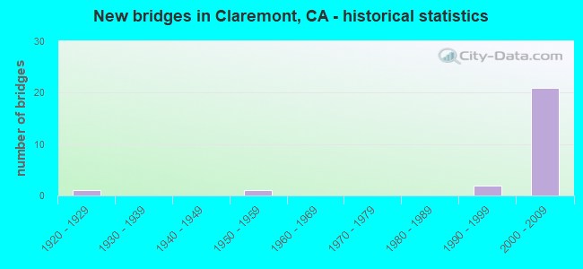
- New bridges - historical statistics
- 11920-1929
- 11950-1959
- 21990-1999
- 212000-2009
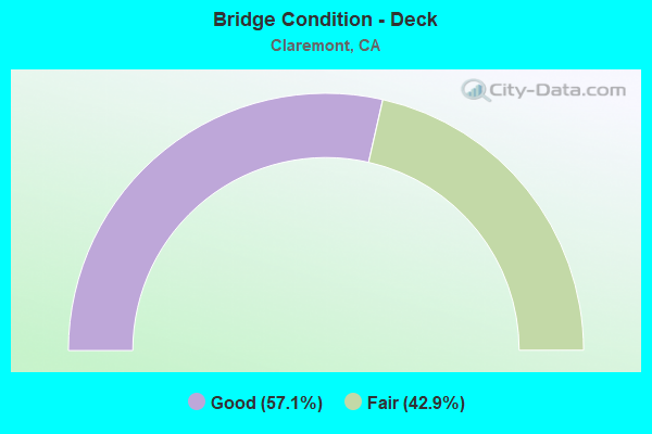
- Bridge Condition - Deck
- 57.1%Good
- 42.9%Fair
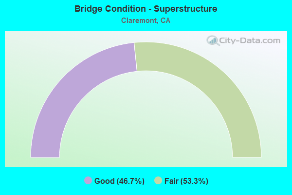
- Bridge Condition - Superstructure
- 46.7%Good
- 53.3%Fair
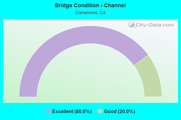
- Bridge Condition - Channel
- 80.0%Excellent
- 20.0%Good
Find on map >> Show street view
Structure Number: 53 2781, Location: 07-LA-000--CLA (Lat: 34.121189, Lng: -117.745444), Route carried "on" structure: City street , Year Built: 1996, Status: Open, Structure Length: 4.18m (13.71ft), Average Daily Traffic: 24,624 (year 2012), Truck Traffic: 4%, Average Future Daily Traffic: 29,549 (year 2042), Design Load: HS 20+Mod, Features Intersected: Live Oak Canyon Channel, Facility Carried by Structure: Baseline Road
Minimum Vertical Clearance: 30+ m (98+ ft), Kilometerpoint: 0.000, Lanes on structure: 4, Owner: State Highway Agency, Approaching Roadway Width: 21.2m (69.6ft), Skew: 2 degrees, Material/Design: Concrete, Design/Construction: Box Beam or Girders - Single/Spread, Number Of Spans In Main Unit: 1, Length of Maximum Span: 40.0m (131.2ft), Curb or Sidewalk Widths: Left: 1.5m (4.9ft), Right: 1.5m (4.9ft), Curb-To-Curb Width: 21.3m (69.9ft), Out-to-Out Width: 25.0m (82.0ft)
Condition: Deck: Fair, Superstructure: Good, Substructure: Good, Channel: Excellent, Operating Rating: 54.1 metric tons, Method Used To Determine Operating Rating: Assigned rating based on Load Factor Design (LFD) reported in metric tons, Inventory Rating: 32.4 metric tons, Method Used To Determine Inventory Rating: Assigned rating based on Load Factor Design (LFD) reported in metric tons, Structural Evaluation: Better than present minimum criteria, Deck Geometry: Superior to present desirable criteria, Waterway Adequacy: Superior to present desirable criteria, Approach Roadway Alignment: Equal to present desirable criteria, Designated Inspection Frequency: Every 24 months, Inspection Date: January 2021, Deck Structure Type: Concrete Cast-file-Place
Find on map >> Show street view
Structure Number: 53 2861, Location: 07-LA-210-R47.21-LVN (Lat: 34.119933, Lng: -117.777067), Route carried "on" structure: City street L0356, Year Built: 2000, Status: Open, Structure Length: 7.20m (23.62ft), Average Daily Traffic: 1,500 (year 2015), Truck Traffic: 3%, Average Future Daily Traffic: 2,103 (year 2043), Design Load: HS 20+Mod, Features Intersected: INTERSTATE 210, Facility Carried by Structure: WHEELER AVENUE
Minimum Vertical Clearance: 30+ m (98+ ft), Kilometerpoint: 0.000, Lanes on structure: 4, Lanes under structure: 8, Owner: State Highway Agency, Approaching Roadway Width: 32.3m (106.0ft), Skew: 10 degrees, Material/Design: Prestressed concrete continuous, Design/Construction: Box Beam or Girders - Multiple, Number Of Spans In Main Unit: 2, Length of Maximum Span: 37.6m (123.4ft), Curb or Sidewalk Widths: Left: 0.0m, Right: 1.5m (4.9ft), Curb-To-Curb Width: 25.6m (84.0ft), Out-to-Out Width: 32.3m (106.0ft)
Condition: Deck: Good, Superstructure: Good, Substructure: Good, Operating Rating: 54.1 metric tons, Method Used To Determine Operating Rating: Assigned rating based on Load Factor Design (LFD) reported in metric tons, Inventory Rating: 32.4 metric tons, Method Used To Determine Inventory Rating: Assigned rating based on Load Factor Design (LFD) reported in metric tons, Structural Evaluation: Better than present minimum criteria, Deck Geometry: Superior to present desirable criteria, Underclear: Meets minimum limits, Approach Roadway Alignment: Equal to present desirable criteria, Designated Inspection Frequency: Every 24 months, Inspection Date: Febuary 2021, Deck Structure Type: Concrete Cast-file-Place
Find on map >> Show street view
Structure Number: 53 2868, Location: 07-LA-210-R49.02-CLA (Lat: 34.120258, Lng: -117.745719), Route carried "on" structure: State highway 210, Year Built: 2000, Status: Open, Structure Length: 1.70m (5.58ft), Average Daily Traffic: 155,000 (year 2012), Truck Traffic: 5%, Average Future Daily Traffic: 162,962 (year 2042), Design Load: HS 20+Mod, Features Intersected: LIVE OAK CANYON WASH
Minimum Vertical Clearance: 30+ m (98+ ft), Kilometerpoint: 49.020, Lanes on structure: 10, Base Highway Network: Yes (Inventory Route: 2, Subroute: 1), Owner: State Highway Agency, Approaching Roadway Width: 58.3m (191.3ft), Skew: 33 degrees, Material/Design: Prestressed concrete, Design/Construction: Slab, Number Of Spans In Main Unit: 1, Length of Maximum Span: 17.0m (55.8ft), Curb-To-Curb Width: 58.3m (191.3ft), Out-to-Out Width: 59.3m (194.6ft)
Condition: Deck: Fair, Superstructure: Fair, Substructure: Good, Channel: Excellent, Operating Rating: 54.1 metric tons, Method Used To Determine Operating Rating: Assigned rating based on Load Factor Design (LFD) reported in metric tons, Inventory Rating: 32.4 metric tons, Method Used To Determine Inventory Rating: Assigned rating based on Load Factor Design (LFD) reported in metric tons, Structural Evaluation: Somewhat better than minimum adequacy, Deck Geometry: Superior to present desirable criteria, Waterway Adequacy: Equal to present desirable criteria, Approach Roadway Alignment: Equal to present desirable criteria, Designated Inspection Frequency: Every 24 months, Inspection Date: January 2021, Deck Structure Type: Concrete Cast-file-Place
Find on map >> Show street view
Structure Number: 53 2869, Location: 07-LA-210-R49.11-CLA (Lat: 34.121047, Lng: -117.743975), Route carried "on" structure: City street , Year Built: 2000, Status: Open, Structure Length: 8.04m (26.38ft), Average Daily Traffic: 1,000 (year 2012), Truck Traffic: 3%, Average Future Daily Traffic: 1,104 (year 2042), Design Load: HS 20+Mod, Features Intersected: INTERSTATE 210, Facility Carried by Structure: LIVE OAK CANYON RD
Minimum Vertical Clearance: 30+ m (98+ ft), Kilometerpoint: 0.000, Lanes on structure: 2, Lanes under structure: 8, Owner: State Highway Agency, Approaching Roadway Width: 9.8m (32.2ft), Material/Design: Prestressed concrete continuous, Design/Construction: Box Beam or Girders - Single/Spread, Number Of Spans In Main Unit: 2, Length of Maximum Span: 42.2m (138.5ft), Curb or Sidewalk Widths: Left: 1.5m (4.9ft), Right: 1.5m (4.9ft), Curb-To-Curb Width: 9.8m (32.2ft), Out-to-Out Width: 13.4m (44.0ft)
Condition: Deck: Fair, Superstructure: Good, Substructure: Good, Operating Rating: 54.1 metric tons, Method Used To Determine Operating Rating: Assigned rating based on Load Factor Design (LFD) reported in metric tons, Inventory Rating: 32.4 metric tons, Method Used To Determine Inventory Rating: Assigned rating based on Load Factor Design (LFD) reported in metric tons, Structural Evaluation: Better than present minimum criteria, Deck Geometry: Equal to present minimum criteria, Underclear: Equal to present minimum criteria, Approach Roadway Alignment: Equal to present desirable criteria, Designated Inspection Frequency: Every 24 months, Inspection Date: January 2021, Deck Structure Type: Concrete Cast-file-Place
Find on map >> Show street view
Structure Number: 53 287, Location: 07-LA-210-R49.37-CLA (Lat: 34.120242, Lng: -117.739772), Route carried "on" structure: State highway 210, Year Built: 2001, Status: Open, Structure Length: 1.65m (5.41ft), Average Daily Traffic: 155,000 (year 2012), Truck Traffic: 5%, Average Future Daily Traffic: 162,962 (year 2042), Design Load: HS 20+Mod, Features Intersected: THOMPSON CREEK
Minimum Vertical Clearance: 30+ m (98+ ft), Kilometerpoint: 49.370, Lanes on structure: 9, Base Highway Network: Yes (Inventory Route: 2, Subroute: 1), Owner: State Highway Agency, Approaching Roadway Width: 73.0m (239.5ft), Skew: 34 degrees, Material/Design: Prestressed concrete, Design/Construction: Slab, Number Of Spans In Main Unit: 1, Length of Maximum Span: 16.5m (54.1ft), Curb-To-Curb Width: 71.3m (233.9ft), Out-to-Out Width: 88.5m (290.4ft)
Condition: Deck: Fair, Superstructure: Fair, Substructure: Good, Channel: Excellent, Operating Rating: 54.1 metric tons, Method Used To Determine Operating Rating: Assigned rating based on Load Factor Design (LFD) reported in metric tons, Inventory Rating: 32.4 metric tons, Method Used To Determine Inventory Rating: Assigned rating based on Load Factor Design (LFD) reported in metric tons, Structural Evaluation: Somewhat better than minimum adequacy, Deck Geometry: Superior to present desirable criteria, Waterway Adequacy: Superior to present desirable criteria, Approach Roadway Alignment: Equal to present desirable criteria, Designated Inspection Frequency: Every 24 months, Inspection Date: January 2021, Deck Structure Type: Concrete Cast-file-Place
Find on map >> Show street view
Structure Number: 53 2871, Location: 07-LA-210-R49.53-CLA (Lat: 34.120683, Lng: -117.736600), Route carried "on" structure: City street L064, Year Built: 2001, Status: Open, Structure Length: 5.97m (19.59ft), Average Daily Traffic: 1,000 (year 2012), Truck Traffic: 2%, Average Future Daily Traffic: 1,367 (year 2042), Design Load: HS 20+Mod, Features Intersected: INTERSTATE 210, Facility Carried by Structure: TOWNE AVE
Minimum Vertical Clearance: 30+ m (98+ ft), Kilometerpoint: 0.000, Lanes on structure: 7, Lanes under structure: 9, Base Highway Network: Yes, Owner: State Highway Agency, Approaching Roadway Width: 32.0m (105.0ft), Skew: 20 degrees, Material/Design: Concrete continuous, Design/Construction: Box Beam or Girders - Multiple, Number Of Spans In Main Unit: 2, Length of Maximum Span: 31.6m (103.7ft), Curb or Sidewalk Widths: Left: 1.5m (4.9ft), Right: 1.5m (4.9ft), Curb-To-Curb Width: 29.0m (95.1ft), Out-to-Out Width: 32.6m (107.0ft)
Condition: Deck: Good, Superstructure: Fair, Substructure: Good, Operating Rating: 54.1 metric tons, Method Used To Determine Operating Rating: Assigned rating based on Load Factor Design (LFD) reported in metric tons, Inventory Rating: 32.4 metric tons, Method Used To Determine Inventory Rating: Assigned rating based on Load Factor Design (LFD) reported in metric tons, Structural Evaluation: Somewhat better than minimum adequacy, Deck Geometry: Meets minimum limits, Underclear: Equal to present minimum criteria, Approach Roadway Alignment: Equal to present desirable criteria, Designated Inspection Frequency: Every 24 months, Inspection Date: January 2021, Deck Structure Type: Concrete Cast-file-Place
Find on map >> Show street view
Structure Number: 53 2872, Location: 07-LA-210-R49.96-CLA (Lat: 34.120581, Lng: -117.729081), Route carried "on" structure: City street L0681, Year Built: 2001, Status: Open, Structure Length: 7.36m (24.15ft), Average Daily Traffic: 2,000 (year 2012), Truck Traffic: 2%, Average Future Daily Traffic: 2,628 (year 2042), Design Load: HS 20+Mod, Features Intersected: INTERSTATE 210, Facility Carried by Structure: MOUNTAIN AVE
Minimum Vertical Clearance: 30+ m (98+ ft), Kilometerpoint: 0.000, Lanes on structure: 4, Lanes under structure: 9, Owner: State Highway Agency, Approaching Roadway Width: 20.6m (67.6ft), Material/Design: Concrete continuous, Design/Construction: Box Beam or Girders - Multiple, Number Of Spans In Main Unit: 2, Length of Maximum Span: 37.2m (122.0ft), Curb or Sidewalk Widths: Left: 1.5m (4.9ft), Right: 1.5m (4.9ft), Curb-To-Curb Width: 17.0m (55.8ft), Out-to-Out Width: 20.6m (67.6ft)
Condition: Deck: Fair, Superstructure: Good, Substructure: Good, Operating Rating: 54.1 metric tons, Method Used To Determine Operating Rating: Assigned rating based on Load Factor Design (LFD) reported in metric tons, Inventory Rating: 32.4 metric tons, Method Used To Determine Inventory Rating: Assigned rating based on Load Factor Design (LFD) reported in metric tons, Structural Evaluation: Better than present minimum criteria, Deck Geometry: Somewhat better than minimum adequacy, Underclear: Meets minimum limits, Approach Roadway Alignment: Equal to present desirable criteria, Designated Inspection Frequency: Every 24 months, Inspection Date: January 2021, Deck Structure Type: Concrete Cast-file-Place
Find on map >> Show street view
Structure Number: 53 2873, Location: 07-LA-210-R50.46-CLA (Lat: 34.120442, Lng: -117.720403), Route carried "on" structure: ServiceCity street Q0932, Year Built: 2001, Status: Open, Structure Length: 7.15m (23.46ft), Average Daily Traffic: 1,000 (year 2012), Truck Traffic: 2%, Average Future Daily Traffic: 1,262 (year 2042), Design Load: HS 20+Mod, Features Intersected: INTERSTATE 210, Facility Carried by Structure: INDIAN HILL BLVD
Minimum Vertical Clearance: 30+ m (98+ ft), Kilometerpoint: 0.000, Lanes on structure: 4, Lanes under structure: 9, Owner: State Highway Agency, Approaching Roadway Width: 26.3m (86.3ft), Skew: 20 degrees, Material/Design: Concrete continuous, Design/Construction: Box Beam or Girders - Multiple, Number Of Spans In Main Unit: 2, Length of Maximum Span: 37.0m (121.4ft), Curb or Sidewalk Widths: Left: 1.5m (4.9ft), Right: 1.5m (4.9ft), Curb-To-Curb Width: 22.7m (74.5ft), Out-to-Out Width: 26.3m (86.3ft)
Condition: Deck: Good, Superstructure: Fair, Substructure: Good, Operating Rating: 54.1 metric tons, Method Used To Determine Operating Rating: Assigned rating based on Load Factor Design (LFD) reported in metric tons, Inventory Rating: 32.4 metric tons, Method Used To Determine Inventory Rating: Assigned rating based on Load Factor Design (LFD) reported in metric tons, Structural Evaluation: Somewhat better than minimum adequacy, Deck Geometry: Superior to present desirable criteria, Underclear: Meets minimum limits, Approach Roadway Alignment: Equal to present desirable criteria, Designated Inspection Frequency: Every 24 months, Inspection Date: January 2021, Deck Structure Type: Concrete Cast-file-Place
Find on map >> Show street view
Structure Number: 53 2874, Location: 07-LA-210-R51.21-CLA (Lat: 34.120325, Lng: -117.707322), Route carried "on" structure: City street Q0982, Year Built: 2001, Status: Open, Structure Length: 7.68m (25.20ft), Average Daily Traffic: 1,500 (year 2012), Truck Traffic: 2%, Average Future Daily Traffic: 2,103 (year 2042), Design Load: HS 20+Mod, Features Intersected: INTERSTATE 210, Facility Carried by Structure: MILLS AVE
Minimum Vertical Clearance: 30+ m (98+ ft), Kilometerpoint: 0.000, Lanes on structure: 4, Lanes under structure: 9, Owner: State Highway Agency, Approaching Roadway Width: 20.6m (67.6ft), Skew: 20 degrees, Material/Design: Prestressed concrete continuous, Design/Construction: Box Beam or Girders - Multiple, Number Of Spans In Main Unit: 2, Length of Maximum Span: 39.2m (128.6ft), Curb or Sidewalk Widths: Left: 5.9m (19.4ft), Right: 5.9m (19.4ft), Curb-To-Curb Width: 19.4m (63.6ft), Out-to-Out Width: 31.8m (104.3ft)
Condition: Deck: Good, Superstructure: Fair, Substructure: Good, Operating Rating: 54.1 metric tons, Method Used To Determine Operating Rating: Assigned rating based on Load Factor Design (LFD) reported in metric tons, Inventory Rating: 32.4 metric tons, Method Used To Determine Inventory Rating: Assigned rating based on Load Factor Design (LFD) reported in metric tons, Structural Evaluation: Somewhat better than minimum adequacy, Deck Geometry: Better than present minimum criteria, Underclear: Meets minimum limits, Approach Roadway Alignment: Equal to present desirable criteria, Designated Inspection Frequency: Every 24 months, Inspection Date: January 2021, Deck Structure Type: Concrete Cast-file-Place
Find on map >> Show street view
Structure Number: 53 2875, Location: 07-LA-210-R51.72-CLA (Lat: 34.120997, Lng: -117.698556), Route carried "on" structure: City street , Year Built: 2001, Status: Open, Structure Length: 9.31m (30.54ft), Average Daily Traffic: 1,200 (year 2012), Truck Traffic: 2%, Average Future Daily Traffic: 1,577 (year 2042), Design Load: HS 20+Mod, Features Intersected: INTERSTATE 210, Facility Carried by Structure: MONTE VISTA AVE
Minimum Vertical Clearance: 30+ m (98+ ft), Kilometerpoint: 0.000, Lanes on structure: 4, Lanes under structure: 10, Owner: State Highway Agency, Approaching Roadway Width: 25.5m (83.7ft), Skew: 12 degrees, Material/Design: Prestressed concrete continuous, Design/Construction: Box Beam or Girders - Multiple, Number Of Spans In Main Unit: 2, Length of Maximum Span: 53.6m (175.9ft), Curb or Sidewalk Widths: Left: 1.5m (4.9ft), Right: 3.0m (9.8ft), Curb-To-Curb Width: 25.5m (83.7ft), Out-to-Out Width: 25.5m (83.7ft)
Condition: Deck: Fair, Superstructure: Fair, Substructure: Good, Operating Rating: 54.1 metric tons, Method Used To Determine Operating Rating: Assigned rating based on Load Factor Design (LFD) reported in metric tons, Inventory Rating: 32.4 metric tons, Method Used To Determine Inventory Rating: Assigned rating based on Load Factor Design (LFD) reported in metric tons, Structural Evaluation: Somewhat better than minimum adequacy, Deck Geometry: Superior to present desirable criteria, Underclear: Meets minimum limits, Approach Roadway Alignment: Equal to present desirable criteria, Designated Inspection Frequency: Every 24 months, Inspection Date: January 2021, Deck Structure Type: Concrete Cast-file-Place
Find on map >> Show street view
Structure Number: 53 2877, Location: 07-LA-210-R51.85-CLA (Lat: 34.121458, Lng: -117.697406), Route carried "on" structure: City street , Year Built: 2001, Status: Open, Structure Length: 15.35m (50.36ft), Average Daily Traffic: 78,000 (year 2012), Truck Traffic: 2%, Average Future Daily Traffic: 267,079 (year 2042), Design Load: HS 20+Mod, Features Intersected: STATE ROUTE 210, Facility Carried by Structure: BASELINE ROAD
Minimum Vertical Clearance: 30+ m (98+ ft), Kilometerpoint: 0.000, Lanes on structure: 6, Lanes under structure: 10, Base Highway Network: Yes, Owner: State Highway Agency, Approaching Roadway Width: 29.4m (96.5ft), Skew: 5 degrees, Material/Design: Prestressed concrete continuous, Design/Construction: Box Beam or Girders - Multiple, Number Of Spans In Main Unit: 3, Length of Maximum Span: 65.8m (215.9ft), Curb or Sidewalk Widths: Left: 1.5m (4.9ft), Right: 1.5m (4.9ft), Curb-To-Curb Width: 27.0m (88.6ft), Out-to-Out Width: 30.0m (98.4ft)
Condition: Deck: Good, Superstructure: Fair, Substructure: Good, Operating Rating: 54.1 metric tons, Method Used To Determine Operating Rating: Assigned rating based on Load Factor Design (LFD) reported in metric tons, Inventory Rating: 32.4 metric tons, Method Used To Determine Inventory Rating: Assigned rating based on Load Factor Design (LFD) reported in metric tons, Structural Evaluation: Somewhat better than minimum adequacy, Deck Geometry: Better than present minimum criteria, Underclear: Equal to present minimum criteria, Approach Roadway Alignment: Equal to present desirable criteria, Designated Inspection Frequency: Every 24 months, Inspection Date: January 2021, Deck Structure Type: Concrete Cast-file-Place
Find on map >> Show street view
Structure Number: 53 2879, Location: 07-LA-210-R51.94-CLA (Lat: 34.122628, Lng: -117.695647), Route carried "on" structure: Ramp Interstate 210, Year Built: 2001, Status: Open, Structure Length: 9.01m (29.56ft), Average Daily Traffic: 5,000 (year 2012), Truck Traffic: 2%, Average Future Daily Traffic: 7,358 (year 2042), Design Load: HS 20+Mod, Features Intersected: INTERSTATE 210, Facility Carried by Structure: BASELINE RD RAMPS
Minimum Vertical Clearance: 30+ m (98+ ft), Kilometerpoint: 51.940, Lanes on structure: 4, Lanes under structure: 11, Base Highway Network: Yes (Inventory Route: 2, Subroute: 1), Owner: State Highway Agency, Approaching Roadway Width: 25.0m (82.0ft), Skew: 30 degrees, Material/Design: Prestressed concrete continuous, Design/Construction: Box Beam or Girders - Multiple, Number Of Spans In Main Unit: 2, Length of Maximum Span: 46.4m (152.2ft), Curb-To-Curb Width: 25.0m (82.0ft), Out-to-Out Width: 26.7m (87.6ft)
Condition: Deck: Good, Superstructure: Fair, Substructure: Good, Operating Rating: 54.1 metric tons, Method Used To Determine Operating Rating: Assigned rating based on Load Factor Design (LFD) reported in metric tons, Inventory Rating: 32.4 metric tons, Method Used To Determine Inventory Rating: Assigned rating based on Load Factor Design (LFD) reported in metric tons, Structural Evaluation: Somewhat better than minimum adequacy, Deck Geometry: Superior to present desirable criteria, Underclear: Equal to present minimum criteria, Approach Roadway Alignment: Equal to present desirable criteria, Designated Inspection Frequency: Every 24 months, Inspection Date: January 2021, Deck Structure Type: Concrete Cast-file-Place
Find on map >> Show street view
Structure Number: 53 2894, Location: 07-LA-405-24.90-ING (Lat: 33.976094, Lng: -118.389286), Route carried "on" structure: City street , Year Built: 2000, Status: Open, Structure Length: 3.45m (11.32ft), Average Daily Traffic: 2,000 (year 2014), Truck Traffic: 1%, Average Future Daily Traffic: 2,359 (year 2043), Design Load: HS 20+Mod, Features Intersected: ROUTE 405 ON &OFF-RAMPS, Facility Carried by Structure: CENTER DR
Minimum Vertical Clearance: 30+ m (98+ ft), Kilometerpoint: 0.000, Lanes on structure: 4, Lanes under structure: 4, Owner: Private, Approaching Roadway Width: 25.6m (84.0ft), Skew: 10 degrees, Material/Design: Prestressed concrete, Design/Construction: Box Beam or Girders - Multiple, Number Of Spans In Main Unit: 1, Length of Maximum Span: 34.5m (113.2ft), Curb or Sidewalk Widths: Left: 3.0m (9.8ft), Right: 2.9m (9.5ft), Curb-To-Curb Width: 25.6m (84.0ft), Out-to-Out Width: 32.1m (105.3ft)
Condition: Deck: Good, Superstructure: Good, Substructure: Good, Operating Rating: 54.1 metric tons, Method Used To Determine Operating Rating: Assigned rating based on Load Factor Design (LFD) reported in metric tons, Inventory Rating: 32.4 metric tons, Method Used To Determine Inventory Rating: Assigned rating based on Load Factor Design (LFD) reported in metric tons, Structural Evaluation: Better than present minimum criteria, Deck Geometry: Superior to present desirable criteria, Underclear: High priority of corrective action, Approach Roadway Alignment: Equal to present minimum criteria, Designated Inspection Frequency: Every 24 months, Inspection Date: Febuary 2021, Deck Structure Type: Concrete Cast-file-Place
Find on map >> Show street view
Structure Number: 53C0994, Location: 0.2MI W/O TOWNE AVE (Lat: 34.126636, Lng: -117.741983), Route carried "on" structure: County highway , Year Built: 1929, Status: Open, Structure Length: 0.79m (2.59ft), Average Daily Traffic: 252 (year 2012), Truck Traffic: 2%, Average Future Daily Traffic: 252 (year 2041), Features Intersected: WEBB CYN CRK, Facility Carried by Structure: WEBB CYN RD
Minimum Vertical Clearance: 30.47m (99.97ft), Kilometerpoint: 0.000, Lanes on structure: 2, Owner: County Highway Agency, Approaching Roadway Width: 5.8m (19.0ft), Material/Design: Concrete, Design/Construction: Arch - Deck, Number Of Spans In Main Unit: 1, Length of Maximum Span: 7.6m (24.9ft), Curb-To-Curb Width: 5.7m (18.7ft), Out-to-Out Width: 6.8m (22.3ft)
Condition: Superstructure: Good, Substructure: Good, Channel: Good, Operating Rating: 27.2 metric tons, Method Used To Determine Operating Rating: Field evaluation and documented engineering judgment, Inventory Rating: 16.2 metric tons, Method Used To Determine Inventory Rating: Field evaluation and documented engineering judgment, Structural Evaluation: Somewhat better than minimum adequacy, Deck Geometry: High priority of corrective action, Waterway Adequacy: Equal to present desirable criteria, Approach Roadway Alignment: Equal to present minimum criteria, Designated Inspection Frequency: Every 24 months, Inspection Date: October 2021, Wearing Surface/Protective System: Wearing Surface: Bituminous
Find on map >> Show street view
Structure Number: 53C2323, Location: 0.1 MI NORTH OF 210 (Lat: 34.121503, Lng: -117.738436), Route carried "on" structure: City street , Year Built: 1998, Status: Open, Structure Length: 1.02m (3.35ft), Average Daily Traffic: 24,624 (year 2015), Truck Traffic: 4%, Average Future Daily Traffic: 29,549 (year 2041), Design Load: HS 20+Mod, Features Intersected: Thompson Creek, Facility Carried by Structure: Baseline Road
Minimum Vertical Clearance: 30.47m (99.97ft), Kilometerpoint: 0.999, Lanes on structure: 4, Owner: City or Municipal Highway Agency, Approaching Roadway Width: 21.2m (69.6ft), Skew: 2 degrees, Material/Design: Concrete, Design/Construction: Slab, Number Of Spans In Main Unit: 1, Length of Maximum Span: 9.9m (32.5ft), Curb or Sidewalk Widths: Left: 1.5m (4.9ft), Right: 1.5m (4.9ft), Curb-To-Curb Width: 21.3m (69.9ft), Out-to-Out Width: 24.6m (80.7ft)
Condition: Deck: Good, Superstructure: Good, Substructure: Good, Channel: Excellent, Operating Rating: 54.1 metric tons, Method Used To Determine Operating Rating: Assigned rating based on Load Factor Design (LFD) reported in metric tons, Inventory Rating: 32.4 metric tons, Method Used To Determine Inventory Rating: Assigned rating based on Load Factor Design (LFD) reported in metric tons, Structural Evaluation: Better than present minimum criteria, Deck Geometry: Superior to present desirable criteria, Waterway Adequacy: Superior to present desirable criteria, Approach Roadway Alignment: Equal to present desirable criteria, Designated Inspection Frequency: Every 48 months, Inspection Date: October 2021, Deck Structure Type: Concrete Cast-file-Place
Find on map >> Show street view
Structure Number: 53 086, Location: 07-LA-010-47.74-CLA (Lat: 34.081536, Lng: -117.719431), Route carried "under" structure: City street , Year Built: 1954, Structure Length: 0. m, Average Daily Traffic: 28,000 (year 2012), Truck Traffic: 2%, Features Intersected: INDIAN HILL BLVD, Facility Carried by Structure: INTERSTATE 10
Minimum Vertical Clearance: 4.40m (14.44ft), Kilometerpoint: 0.000, Lanes on structure: 10, Lanes under structure: 5, Material/Design: Prestressed concrete, Design/Construction: Box Beam or Girders - Multiple, Length of Maximum Span: 24.8m (81.4ft)
Find on map >> Show street view
Structure Number: 53 2869, Location: 07-LA-210-R49.11-CLA (Lat: 34.121047, Lng: -117.743975), Route carried "under" structure: State highway 210, Year Built: 2000, Structure Length: 0. m, Average Daily Traffic: 155,000 (year 2012), Truck Traffic: 5%, Features Intersected: INTERSTATE 210, Facility Carried by Structure: LIVE OAK CANYON RD
Minimum Vertical Clearance: 5.41m (17.75ft), Kilometerpoint: 49.110, Lanes on structure: 2, Lanes under structure: 8, Material/Design: Prestressed concrete continuous, Design/Construction: Box Beam or Girders - Single/Spread, Length of Maximum Span: 42.2m (138.5ft)
Find on map >> Show street view
Structure Number: 53 2871, Location: 07-LA-210-R49.53-CLA (Lat: 34.120683, Lng: -117.736600), Route carried "under" structure: State highway 210, Year Built: 2001, Structure Length: 0. m, Average Daily Traffic: 155,000 (year 2012), Truck Traffic: 5%, Features Intersected: INTERSTATE 210, Facility Carried by Structure: TOWNE AVE
Minimum Vertical Clearance: 5.13m (16.83ft), Kilometerpoint: 49.530, Lanes on structure: 7, Lanes under structure: 9, Material/Design: Concrete continuous, Design/Construction: Box Beam or Girders - Multiple, Length of Maximum Span: 31.6m (103.7ft)
Find on map >> Show street view
Structure Number: 53 2872, Location: 07-LA-210-R49.96-CLA (Lat: 34.120581, Lng: -117.729081), Route carried "under" structure: State highway 210, Year Built: 2001, Structure Length: 0. m, Average Daily Traffic: 155,000 (year 2012), Truck Traffic: 5%, Features Intersected: INTERSTATE 210, Facility Carried by Structure: MOUNTAIN AVE
Minimum Vertical Clearance: 5.23m (17.16ft), Kilometerpoint: 49.960, Lanes on structure: 4, Lanes under structure: 9, Material/Design: Concrete continuous, Design/Construction: Box Beam or Girders - Multiple, Length of Maximum Span: 37.2m (122.0ft)
Find on map >> Show street view
Structure Number: 53 2873, Location: 07-LA-210-R50.46-CLA (Lat: 34.120442, Lng: -117.720403), Route carried "under" structure: State highway 210, Year Built: 2001, Structure Length: 0. m, Average Daily Traffic: 155,000 (year 2012), Truck Traffic: 5%, Features Intersected: INTERSTATE 210, Facility Carried by Structure: INDIAN HILL BLVD
Minimum Vertical Clearance: 5.23m (17.16ft), Kilometerpoint: 50.460, Lanes on structure: 4, Lanes under structure: 9, Material/Design: Concrete continuous, Design/Construction: Box Beam or Girders - Multiple, Length of Maximum Span: 37.0m (121.4ft)
Find on map >> Show street view
Structure Number: 53 2874, Location: 07-LA-210-R51.21-CLA (Lat: 34.120325, Lng: -117.707322), Route carried "under" structure: State highway 210, Year Built: 2001, Structure Length: 0. m, Average Daily Traffic: 155,000 (year 2012), Truck Traffic: 5%, Features Intersected: INTERSTATE 210, Facility Carried by Structure: MILLS AVE
Minimum Vertical Clearance: 6.02m (19.75ft), Kilometerpoint: 51.210, Lanes on structure: 4, Lanes under structure: 9, Material/Design: Prestressed concrete continuous, Design/Construction: Box Beam or Girders - Multiple, Length of Maximum Span: 39.2m (128.6ft)
Find on map >> Show street view
Structure Number: 53 2875, Location: 07-LA-210-R51.72-CLA (Lat: 34.120997, Lng: -117.698556), Route carried "under" structure: State highway 210, Year Built: 2001, Structure Length: 0. m, Average Daily Traffic: 155,000 (year 2012), Truck Traffic: 5%, Features Intersected: INTERSTATE 210, Facility Carried by Structure: MONTE VISTA AVE
Minimum Vertical Clearance: 5.28m (17.32ft), Kilometerpoint: 51.720, Lanes on structure: 4, Lanes under structure: 10, Material/Design: Prestressed concrete continuous, Design/Construction: Box Beam or Girders - Multiple, Length of Maximum Span: 53.6m (175.9ft)
Find on map >> Show street view
Structure Number: 53 2877, Location: 07-LA-210-R51.85-CLA (Lat: 34.121458, Lng: -117.697406), Route carried "under" structure: State highway 210, Year Built: 2001, Structure Length: 0. m, Average Daily Traffic: 168,000 (year 2012), Truck Traffic: 5%, Features Intersected: STATE ROUTE 210, Facility Carried by Structure: BASELINE ROAD
Minimum Vertical Clearance: 5.26m (17.26ft), Kilometerpoint: 51.850, Lanes on structure: 6, Lanes under structure: 10, Material/Design: Prestressed concrete continuous, Design/Construction: Box Beam or Girders - Multiple, Length of Maximum Span: 65.8m (215.9ft)
Find on map >> Show street view
Structure Number: 53 2879, Location: 07-LA-210-R51.94-CLA (Lat: 34.122628, Lng: -117.695647), Route carried "under" structure: State highway 210, Year Built: 2001, Structure Length: 0. m, Average Daily Traffic: 155,000 (year 2012), Truck Traffic: 5%, Features Intersected: INTERSTATE 210, Facility Carried by Structure: BASELINE RD RAMPS
Minimum Vertical Clearance: 5.33m (17.49ft), Kilometerpoint: 51.940, Lanes on structure: 4, Lanes under structure: 11, Material/Design: Prestressed concrete continuous, Design/Construction: Box Beam or Girders - Multiple, Length of Maximum Span: 46.4m (152.2ft)
Find on map >> Show street view
Structure Number: 53 2896, Location: 07-LA-210-R50.52-CLA (Lat: 34.120472, Lng: -117.719533), Route carried "under" structure: State highway 210, Year Built: 2001, Structure Length: 0. m, Average Daily Traffic: 155,000 (year 2009), Truck Traffic: 5%, Features Intersected: INTERSTATE 210, Facility Carried by Structure: INDIAN HILL FLUME
Minimum Vertical Clearance: 5.08m (16.67ft), Kilometerpoint: 50.520, Lanes under structure: 9, Material/Design: Concrete continuous, Design/Construction: Box Beam or Girders - Multiple, Length of Maximum Span: 36.1m (118.4ft)