Bridge Statistics for Cle Elum, Washington (WA)
Condition, Traffic, Stress, Structural Evaluation, Project Costs
- National Bridge Inventory (NBI) Statistics
- 38Number of bridges
- 715ft / 218mTotal length
- $94,224,000Total costs
- 369,694Total average daily traffic
- 72,383Total average daily truck traffic
- National Bridge Inventory (NBI) Registered Bridges for Cle Elum
- No street view available for this location
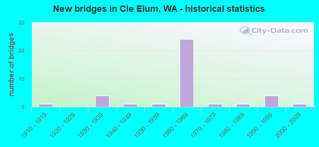
- New bridges - historical statistics
- 11910-1919
- 41930-1939
- 11940-1949
- 11950-1959
- 241960-1969
- 11970-1979
- 11980-1989
- 41990-1999
- 12000-2009
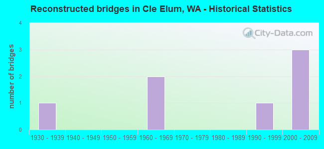
- Reconstructed bridges - Historical Statistics
- 11930-1939
- 01940-1949
- 01950-1959
- 21960-1969
- 01970-1979
- 01980-1989
- 11990-1999
- 32000-2009
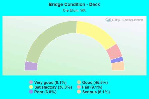
- Bridge Condition - Deck
- 6.1%Very good
- 45.5%Good
- 30.3%Satisfactory
- 9.1%Fair
- 3.0%Poor
- 6.1%Serious
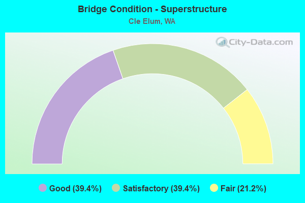
- Bridge Condition - Superstructure
- 39.4%Good
- 39.4%Satisfactory
- 21.2%Fair
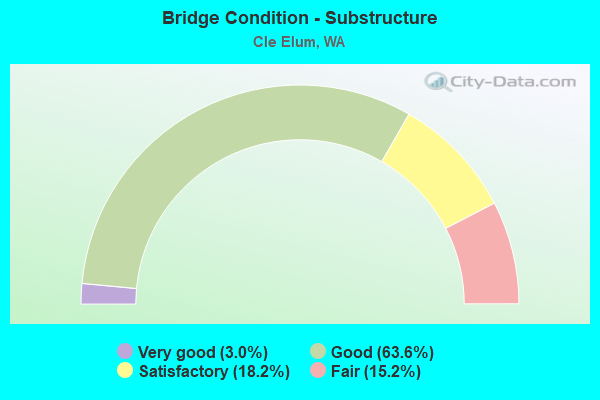
- Bridge Condition - Substructure
- 3.0%Very good
- 63.6%Good
- 18.2%Satisfactory
- 15.2%Fair
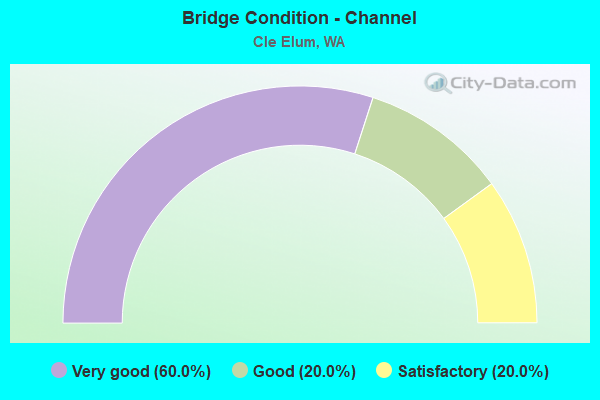
- Bridge Condition - Channel
- 60.0%Very good
- 20.0%Good
- 20.0%Satisfactory
Find on map >> Show street view
Structure Number: DB, Location: 2.1 N JCT SR 903 (Lat: 47.196642, Lng: -120.944639), Route carried "on" structure: State highway 903, Year Built: 1938, Status: Posted for load, Structure Length: 0.76m (2.49ft), Average Daily Traffic: 5,883 (year 2019), Truck Traffic: 8%, Average Future Daily Traffic: 7,647 (year 2039), Features Intersected: ROSLYN CR
Minimum Vertical Clearance: 30+ m (98+ ft), Kilometerpoint: 3.669, Lanes on structure: 2, Owner: State Highway Agency, Approaching Roadway Width: 8.5m (27.9ft), Material/Design: Concrete, Design/Construction: Slab, Number Of Spans In Main Unit: 1, Length of Maximum Span: 6.7m (22.0ft), Curb or Sidewalk Widths: Left: 1.4m (4.6ft), Right: 0.0m, Curb-To-Curb Width: 7.2m (23.6ft), Out-to-Out Width: 7.6m (24.9ft)
Condition: Deck: Good, Superstructure: Satisfactory, Substructure: Fair, Channel: Very good, Operating Rating: 30.5 metric tons, Method Used To Determine Operating Rating: Load and Resistance Factor Rating (LRFR) rating reported by rating factor(RF) method using HL-93 loadings, Inventory Rating: 23.3 metric tons, Method Used To Determine Inventory Rating: Load and Resistance Factor Rating (LRFR) rating reported by rating factor(RF) method using HL-93 loadings, Structural Evaluation: Somewhat better than minimum adequacy, Deck Geometry: High priority of replacement, Waterway Adequacy: Equal to present desirable criteria, Approach Roadway Alignment: Equal to present desirable criteria, Bridge Posting: Required (Relationship of Operating Rating to Maximum Legal Load: 10.0 - 19.9% below), Length Of Structure Improvement: 0.76m (2.49ft), Designated Inspection Frequency: Every 24 months, Inspection Date: August 2021, Bridge Improvement Cost: $150,000, Roadway Improvement Cost: $30,000, Total Project Cost: $300,000 ( Estimate for 2014), Deck Structure Type: Concrete Cast-file-Place, Wearing Surface/Protective System: Wearing Surface: Bituminous, Membrane: Preformed Fabric
Find on map >> Show street view
Structure Number: 267A, Location: 26.3 E KING CO (Lat: 47.186194, Lng: -121.043611), Route carried "on" structure: Interstate 90, Year Built: 1917, Year Reconstructed: 1930, Status: Open, Structure Length: 6.28m (20.60ft), Average Daily Traffic: 17,483 (year 2019), Truck Traffic: 20%, Average Future Daily Traffic: 22,727 (year 2039), Features Intersected: YAKIMA RIVER
Minimum Vertical Clearance: 30+ m (98+ ft), Kilometerpoint: 126.832, Lanes on structure: 2, Base Highway Network: Yes, Owner: State Highway Agency, Approaching Roadway Width: 12.5m (41.0ft), Material/Design: Concrete continuous, Design/Construction: Arch - Deck, Number Of Spans In Main Unit: 2, Length of Maximum Span: 30.5m (100.1ft), Curb-To-Curb Width: 12.5m (41.0ft), Out-to-Out Width: 13.1m (43.0ft)
Condition: Deck: Satisfactory, Superstructure: Satisfactory, Substructure: Satisfactory, Channel: Good, Operating Rating: 29.8 metric tons, Method Used To Determine Operating Rating: Load and Resistance Factor Rating (LRFR) rating reported by rating factor(RF) method using HL-93 loadings, Inventory Rating: 23.0 metric tons, Method Used To Determine Inventory Rating: Load and Resistance Factor Rating (LRFR) rating reported by rating factor(RF) method using HL-93 loadings, Structural Evaluation: Somewhat better than minimum adequacy, Deck Geometry: Better than present minimum criteria, Waterway Adequacy: Equal to present desirable criteria, Approach Roadway Alignment: Equal to present desirable criteria, Length Of Structure Improvement: 6.28m (20.60ft), Designated Inspection Frequency: Every 24 months, Inspection Date: September 2021, Bridge Improvement Cost: $1,772,000, Roadway Improvement Cost: $354,000, Total Project Cost: $3,543,000 ( Estimate for 2014), Deck Structure Type: Concrete Cast-file-Place, Wearing Surface/Protective System: Wearing Surface: Monolithic Concrete
Find on map >> Show street view
Structure Number: 1403A, Location: 1.3 E JCT SR 970 (Lat: 47.168472, Lng: -120.833778), Route carried "on" structure: State highway 10, Year Built: 1930, Status: Open, Structure Length: 5.18m (16.99ft), Average Daily Traffic: 1,361 (year 2019), Truck Traffic: 8%, Average Future Daily Traffic: 1,769 (year 2039), Design Load: H 15, Features Intersected: TEANAWAY RIVER
Minimum Vertical Clearance: 30+ m (98+ ft), Kilometerpoint: 143.779, Lanes on structure: 2, Owner: State Highway Agency, Approaching Roadway Width: 8.5m (27.9ft), Material/Design: Steel, Design/Construction: Truss - Thru, Number Of Spans In Main Unit: 1, Number Of Approach Spans: 2, Length of Maximum Span: 31.7m (104.0ft), Curb-To-Curb Width: 7.3m (24.0ft), Out-to-Out Width: 7.9m (25.9ft)
Condition: Deck: Serious, Superstructure: Fair, Substructure: Fair, Channel: Satisfactory, Operating Rating: 37.2 metric tons, Method Used To Determine Operating Rating: Load Factor (LF), Inventory Rating: 21.8 metric tons, Method Used To Determine Inventory Rating: Load Factor (LF), Structural Evaluation: Somewhat better than minimum adequacy, Deck Geometry: Meets minimum limits, Waterway Adequacy: Equal to present desirable criteria, Approach Roadway Alignment: Equal to present desirable criteria, Length Of Structure Improvement: 5.18m (16.99ft), Designated Inspection Frequency: Every 24 months, Critical Feature Inspection Frequency: Every 24 months, Inspection Date: October 2020, Critical Feature Inspection Date: October 2020, Bridge Improvement Cost: $1,020,000, Roadway Improvement Cost: $204,000, Total Project Cost: $2,040,000 ( Estimate for 2014), Deck Structure Type: Concrete Cast-file-Place, Wearing Surface/Protective System: Wearing Surface: Bituminous
Find on map >> Show street view
Structure Number: 2222A, Location: 2.0 E JCT SR 970 (Lat: 47.165617, Lng: -120.819053), Route carried "on" structure: State highway 10, Year Built: 1937, Year Reconstructed: 2012, Status: Open, Structure Length: 13.11m (43.01ft), Average Daily Traffic: 1,361 (year 2019), Truck Traffic: 8%, Average Future Daily Traffic: 1,769 (year 2039), Design Load: H 15, Features Intersected: TERRAIN
Minimum Vertical Clearance: 30+ m (98+ ft), Kilometerpoint: 145.018, Lanes on structure: 2, Owner: State Highway Agency, Approaching Roadway Width: 8.8m (28.9ft), Material/Design: Steel, Design/Construction: Stringer/Multi-beam, Number Of Spans In Main Unit: 15, Length of Maximum Span: 10.1m (33.1ft), Curb-To-Curb Width: 8.7m (28.5ft), Out-to-Out Width: 9.7m (31.8ft)
Condition: Deck: Very good, Superstructure: Fair, Substructure: Fair, Operating Rating: 50.8 metric tons, Method Used To Determine Operating Rating: Load Factor (LF), Inventory Rating: 29.9 metric tons, Method Used To Determine Inventory Rating: Load Factor (LF), Structural Evaluation: Somewhat better than minimum adequacy, Deck Geometry: Somewhat better than minimum adequacy, Approach Roadway Alignment: Equal to present minimum criteria, Length Of Structure Improvement: 13.11m (43.01ft), Designated Inspection Frequency: Every 24 months, Inspection Date: June 2021, Bridge Improvement Cost: $2,666,000, Roadway Improvement Cost: $533,000, Total Project Cost: $5,332,000 ( Estimate for 2014), Deck Structure Type: Concrete Cast-file-Place, Wearing Surface/Protective System: Wearing Surface: Monolithic Concrete, Deck Protection: Epoxy Coated Reinforcing
Find on map >> Show street view
Structure Number: 3527A, Location: 28.2 E KING CO (Lat: 47.184500, Lng: -121.004889), Route carried "on" structure: Interstate 90, Year Built: 1949, Status: Open, Structure Length: 9.05m (29.69ft), Average Daily Traffic: 16,300 (year 2019), Truck Traffic: 20%, Average Future Daily Traffic: 21,190 (year 2039), Design Load: HS 20, Features Intersected: CLE ELUM RIVER
Minimum Vertical Clearance: 5.77m (18.93ft), Kilometerpoint: 130.019, Lanes on structure: 2, Base Highway Network: Yes, Owner: State Highway Agency, Approaching Roadway Width: 14.6m (47.9ft), Material/Design: Steel, Design/Construction: Truss - Thru, Number Of Spans In Main Unit: 1, Number Of Approach Spans: 2, Length of Maximum Span: 67.1m (220.1ft), Curb-To-Curb Width: 9.4m (30.8ft), Out-to-Out Width: 10.4m (34.1ft)
Condition: Deck: Satisfactory, Superstructure: Satisfactory, Substructure: Satisfactory, Channel: Very good, Operating Rating: 66.2 metric tons, Method Used To Determine Operating Rating: Load Factor (LF), Inventory Rating: 39.9 metric tons, Method Used To Determine Inventory Rating: Load Factor (LF), Structural Evaluation: Equal to present minimum criteria, Deck Geometry: Meets minimum limits, Waterway Adequacy: Equal to present desirable criteria, Approach Roadway Alignment: Equal to present desirable criteria, Length Of Structure Improvement: 9.05m (29.69ft), Designated Inspection Frequency: Every 24 months, Critical Feature Inspection Frequency: Every 24 months, Inspection Date: October 2020, Critical Feature Inspection Date: October 2020, Bridge Improvement Cost: $2,970,000, Roadway Improvement Cost: $594,000, Total Project Cost: $5,940,000 ( Estimate for 2014), Deck Structure Type: Concrete Cast-file-Place, Wearing Surface/Protective System: Wearing Surface: Low Slump Concrete
Find on map >> Show street view
Structure Number: 6868A, Location: 26.3 E KING CO (Lat: 47.186278, Lng: -121.043472), Route carried "on" structure: Interstate 90, Year Built: 1962, Year Reconstructed: 2000, Status: Open, Structure Length: 7.80m (25.59ft), Average Daily Traffic: 17,483 (year 2019), Truck Traffic: 20%, Average Future Daily Traffic: 22,727 (year 2039), Design Load: HS 20, Features Intersected: YAKIMA RIVER
Minimum Vertical Clearance: 30+ m (98+ ft), Kilometerpoint: 126.832, Lanes on structure: 3, Base Highway Network: Yes, Owner: State Highway Agency, Approaching Roadway Width: 16.2m (53.1ft), Material/Design: Concrete continuous, Design/Construction: Box Beam or Girders - Multiple, Number Of Spans In Main Unit: 4, Length of Maximum Span: 32.3m (106.0ft), Curb-To-Curb Width: 16.2m (53.1ft), Out-to-Out Width: 16.4m (53.8ft)
Condition: Deck: Satisfactory, Superstructure: Good, Substructure: Good, Channel: Good, Operating Rating: 54.4 metric tons, Method Used To Determine Operating Rating: Load Factor (LF), Inventory Rating: 32.7 metric tons, Method Used To Determine Inventory Rating: Load Factor (LF), Structural Evaluation: Better than present minimum criteria, Deck Geometry: Equal to present minimum criteria, Waterway Adequacy: Equal to present desirable criteria, Approach Roadway Alignment: Equal to present desirable criteria, Length Of Structure Improvement: 7.80m (25.59ft), Designated Inspection Frequency: Every 24 months, Inspection Date: September 2021, Bridge Improvement Cost: $2,816,000, Roadway Improvement Cost: $563,000, Total Project Cost: $5,632,000 ( Estimate for 2014), Deck Structure Type: Concrete Cast-file-Place, Wearing Surface/Protective System: Wearing Surface: Latex Concrete
Find on map >> Show street view
Structure Number: 6868B, Location: 28.2 E KING CO (Lat: 47.184222, Lng: -121.004722), Route carried "on" structure: Interstate 90, Year Built: 1962, Status: Open, Structure Length: 9.05m (29.69ft), Average Daily Traffic: 16,300 (year 2019), Truck Traffic: 20%, Average Future Daily Traffic: 21,190 (year 2039), Design Load: HS 20, Features Intersected: CLE ELUM RIVER
Minimum Vertical Clearance: 5.36m (17.59ft), Kilometerpoint: 130.019, Lanes on structure: 2, Base Highway Network: Yes, Owner: State Highway Agency, Approaching Roadway Width: 14.6m (47.9ft), Material/Design: Steel, Design/Construction: Truss - Thru, Number Of Spans In Main Unit: 1, Number Of Approach Spans: 2, Length of Maximum Span: 67.1m (220.1ft), Curb-To-Curb Width: 8.6m (28.2ft), Out-to-Out Width: 10.0m (32.8ft)
Condition: Deck: Satisfactory, Superstructure: Fair, Substructure: Satisfactory, Channel: Very good, Operating Rating: 59.9 metric tons, Method Used To Determine Operating Rating: Load Factor (LF), Inventory Rating: 35.4 metric tons, Method Used To Determine Inventory Rating: Load Factor (LF), Structural Evaluation: Somewhat better than minimum adequacy, Deck Geometry: High priority of corrective action, Waterway Adequacy: Equal to present desirable criteria, Approach Roadway Alignment: Equal to present desirable criteria, Length Of Structure Improvement: 9.05m (29.69ft), Designated Inspection Frequency: Every 24 months, Critical Feature Inspection Frequency: Every 24 months, Inspection Date: October 2020, Critical Feature Inspection Date: October 2020, Bridge Improvement Cost: $2,970,000, Roadway Improvement Cost: $594,000, Total Project Cost: $5,940,000 ( Estimate for 2014), Deck Structure Type: Concrete Cast-file-Place, Wearing Surface/Protective System: Wearing Surface: Low Slump Concrete
Find on map >> Show street view
Structure Number: 6883D, Location: 25.6 E KING CO (Lat: 47.194778, Lng: -121.052528), Route carried "on" structure: Interstate 90, Year Built: 1962, Status: Open, Structure Length: 3.17m (10.40ft), Average Daily Traffic: 16,369 (year 2019), Truck Traffic: 20%, Average Future Daily Traffic: 21,279 (year 2039), Design Load: HS 20, Features Intersected: GOLF COURSE RD
Minimum Vertical Clearance: 30+ m (98+ ft), Kilometerpoint: 125.625, Lanes on structure: 2, Lanes under structure: 2, Base Highway Network: Yes, Owner: State Highway Agency, Approaching Roadway Width: 12.8m (42.0ft), Material/Design: Prestressed concrete, Design/Construction: Stringer/Multi-beam, Number Of Spans In Main Unit: 3, Length of Maximum Span: 9.8m (32.2ft), Curb-To-Curb Width: 11.6m (38.1ft), Out-to-Out Width: 12.8m (42.0ft)
Condition: Deck: Good, Superstructure: Satisfactory, Substructure: Satisfactory, Operating Rating: 52.6 metric tons, Method Used To Determine Operating Rating: Load Factor (LF), Inventory Rating: 30.8 metric tons, Method Used To Determine Inventory Rating: Load Factor (LF), Structural Evaluation: Equal to present minimum criteria, Deck Geometry: Equal to present minimum criteria, Underclear: Meets minimum limits, Approach Roadway Alignment: Equal to present desirable criteria, Length Of Structure Improvement: 3.17m (10.40ft), Designated Inspection Frequency: Every 24 months, Inspection Date: Febuary 2020, Bridge Improvement Cost: $915,000, Roadway Improvement Cost: $183,000, Total Project Cost: $1,830,000 ( Estimate for 2014), Deck Structure Type: Concrete Cast-file-Place, Wearing Surface/Protective System: Wearing Surface: Latex Concrete
Find on map >> Show street view
Structure Number: 6883E, Location: 25.6 E KING CO (Lat: 47.195056, Lng: -121.052306), Route carried "on" structure: Interstate 90, Year Built: 1962, Status: Open, Structure Length: 3.17m (10.40ft), Average Daily Traffic: 16,369 (year 2019), Truck Traffic: 20%, Average Future Daily Traffic: 21,279 (year 2039), Design Load: HS 20, Features Intersected: GOLF COURSE RD
Minimum Vertical Clearance: 30+ m (98+ ft), Kilometerpoint: 125.625, Lanes on structure: 2, Lanes under structure: 2, Base Highway Network: Yes, Owner: State Highway Agency, Approaching Roadway Width: 12.8m (42.0ft), Material/Design: Prestressed concrete, Design/Construction: Stringer/Multi-beam, Number Of Spans In Main Unit: 3, Length of Maximum Span: 9.8m (32.2ft), Curb-To-Curb Width: 11.6m (38.1ft), Out-to-Out Width: 12.8m (42.0ft)
Condition: Deck: Good, Superstructure: Good, Substructure: Fair, Operating Rating: 52.6 metric tons, Method Used To Determine Operating Rating: Load Factor (LF), Inventory Rating: 30.8 metric tons, Method Used To Determine Inventory Rating: Load Factor (LF), Structural Evaluation: Somewhat better than minimum adequacy, Deck Geometry: Equal to present minimum criteria, Underclear: Meets minimum limits, Approach Roadway Alignment: Equal to present desirable criteria, Length Of Structure Improvement: 3.17m (10.40ft), Designated Inspection Frequency: Every 24 months, Inspection Date: Febuary 2020, Bridge Improvement Cost: $915,000, Roadway Improvement Cost: $183,000, Total Project Cost: $1,830,000 ( Estimate for 2014), Deck Structure Type: Concrete Cast-file-Place, Wearing Surface/Protective System: Wearing Surface: Latex Concrete
Find on map >> Show street view
Structure Number: 7062A, Location: 27.8 E KING CO (Lat: 47.183361, Lng: -121.014833), Route carried "on" structure: County highway , Year Built: 1963, Status: Open, Structure Length: 7.13m (23.39ft), Average Daily Traffic: 1,145 (year 2012), Truck Traffic: 5%, Design Load: HS 20, Features Intersected: I-90, Facility Carried by Structure: BULLFROG RD
Minimum Vertical Clearance: 30+ m (98+ ft), Kilometerpoint: 0.145, Lanes on structure: 2, Lanes under structure: 4, Owner: State Highway Agency, Approaching Roadway Width: 8.2m (26.9ft), Material/Design: Prestressed concrete, Design/Construction: Stringer/Multi-beam, Number Of Spans In Main Unit: 4, Length of Maximum Span: 22.6m (74.1ft), Curb-To-Curb Width: 7.9m (25.9ft), Out-to-Out Width: 9.4m (30.8ft)
Condition: Deck: Satisfactory, Superstructure: Fair, Substructure: Satisfactory, Operating Rating: 81.6 metric tons, Method Used To Determine Operating Rating: Load Factor (LF), Inventory Rating: 48.1 metric tons, Method Used To Determine Inventory Rating: Load Factor (LF), Structural Evaluation: Somewhat better than minimum adequacy, Deck Geometry: Meets minimum limits, Underclear: Meets minimum limits, Approach Roadway Alignment: Equal to present desirable criteria, Length Of Structure Improvement: 7.13m (23.39ft), Designated Inspection Frequency: Every 24 months, Inspection Date: May 2020, Bridge Improvement Cost: $1,357,000, Roadway Improvement Cost: $271,000, Total Project Cost: $2,714,000 ( Estimate for 2014), Deck Structure Type: Concrete Cast-file-Place, Wearing Surface/Protective System: Wearing Surface: Latex Concrete
Find on map >> Show street view
Structure Number: 7543A, Location: 0.8 E JCT SR 970 (Lat: 47.175639, Lng: -120.891361), Route carried "on" structure: Interstate 90, Year Built: 1965, Status: Open, Structure Length: 11.43m (37.50ft), Average Daily Traffic: 14,037 (year 2019), Truck Traffic: 20%, Average Future Daily Traffic: 18,248 (year 2039), Design Load: HS 20, Features Intersected: LOWER PEOH PT RD & TRAIL
Minimum Vertical Clearance: 30+ m (98+ ft), Kilometerpoint: 139.417, Lanes on structure: 2, Lanes under structure: 2, Base Highway Network: Yes, Owner: State Highway Agency, Approaching Roadway Width: 11.6m (38.1ft), Skew: 5 degrees, Material/Design: Prestressed concrete continuous, Design/Construction: Stringer/Multi-beam, Number Of Spans In Main Unit: 4, Length of Maximum Span: 30.2m (99.1ft), Curb-To-Curb Width: 9.1m (29.9ft), Out-to-Out Width: 10.7m (35.1ft)
Condition: Deck: Poor, Superstructure: Satisfactory, Substructure: Good, Operating Rating: 74.4 metric tons, Method Used To Determine Operating Rating: Load Factor (LF), Inventory Rating: 43.5 metric tons, Method Used To Determine Inventory Rating: Load Factor (LF), Structural Evaluation: Equal to present minimum criteria, Deck Geometry: Meets minimum limits, Underclear: Somewhat better than minimum adequacy, Approach Roadway Alignment: Equal to present desirable criteria, Length Of Structure Improvement: 11.43m (37.50ft), Designated Inspection Frequency: Every 24 months, Inspection Date: June 2021, Bridge Improvement Cost: $3,000,000, Roadway Improvement Cost: $600,000, Total Project Cost: $6,000,000 ( Estimate for 2014), Deck Structure Type: Concrete Cast-file-Place, Wearing Surface/Protective System: Wearing Surface: Latex Concrete
Find on map >> Show street view
Structure Number: 7543B, Location: 0.8 E JCT SR 970 (Lat: 47.175444, Lng: -120.890750), Route carried "on" structure: Interstate 90, Year Built: 1965, Status: Open, Structure Length: 11.43m (37.50ft), Average Daily Traffic: 14,037 (year 2019), Truck Traffic: 20%, Average Future Daily Traffic: 18,248 (year 2039), Design Load: HS 20, Features Intersected: LOWER PEOH PT RD & TRAIL
Minimum Vertical Clearance: 30+ m (98+ ft), Kilometerpoint: 139.434, Lanes on structure: 2, Lanes under structure: 2, Base Highway Network: Yes, Owner: State Highway Agency, Approaching Roadway Width: 11.6m (38.1ft), Skew: 5 degrees, Material/Design: Prestressed concrete continuous, Design/Construction: Stringer/Multi-beam, Number Of Spans In Main Unit: 4, Length of Maximum Span: 30.2m (99.1ft), Curb-To-Curb Width: 9.1m (29.9ft), Out-to-Out Width: 10.7m (35.1ft)
Condition: Deck: Fair, Superstructure: Satisfactory, Substructure: Good, Operating Rating: 74.4 metric tons, Method Used To Determine Operating Rating: Load Factor (LF), Inventory Rating: 43.5 metric tons, Method Used To Determine Inventory Rating: Load Factor (LF), Structural Evaluation: Equal to present minimum criteria, Deck Geometry: Meets minimum limits, Underclear: Somewhat better than minimum adequacy, Approach Roadway Alignment: Equal to present desirable criteria, Length Of Structure Improvement: 11.43m (37.50ft), Designated Inspection Frequency: Every 24 months, Inspection Date: June 2021, Bridge Improvement Cost: $3,000,000, Roadway Improvement Cost: $600,000, Total Project Cost: $6,000,000 ( Estimate for 2014), Deck Structure Type: Concrete Cast-file-Place, Wearing Surface/Protective System: Wearing Surface: Latex Concrete
Find on map >> Show street view
Structure Number: 7574A, Location: 3.9 E JCT SR 970 (Lat: 47.157972, Lng: -120.833778), Route carried "on" structure: County highway , Year Built: 1965, Status: Open, Structure Length: 8.26m (27.10ft), Average Daily Traffic: 565 (year 2012), Truck Traffic: 5%, Average Future Daily Traffic: 646 (year 2036), Design Load: HS 15, Features Intersected: I-90, Facility Carried by Structure: THORP PRAIRIE RD
Minimum Vertical Clearance: 30+ m (98+ ft), Kilometerpoint: 10.461, Lanes on structure: 2, Lanes under structure: 4, Owner: State Highway Agency, Approaching Roadway Width: 8.5m (27.9ft), Skew: 1 degrees, Material/Design: Prestressed concrete, Design/Construction: Stringer/Multi-beam, Number Of Spans In Main Unit: 4, Length of Maximum Span: 23.2m (76.1ft), Curb or Sidewalk Widths: Left: 0.7m (2.3ft), Right: 0.7m (2.3ft), Curb-To-Curb Width: 7.3m (24.0ft), Out-to-Out Width: 9.8m (32.2ft)
Condition: Deck: Good, Superstructure: Satisfactory, Substructure: Good, Operating Rating: 17.8 metric tons, Method Used To Determine Operating Rating: Load and Resistance Factor Rating (LRFR) rating reported by rating factor(RF) method using HL-93 loadings, Inventory Rating: 13.6 metric tons, Method Used To Determine Inventory Rating: Load and Resistance Factor Rating (LRFR) rating reported by rating factor(RF) method using HL-93 loadings, Structural Evaluation: Meets minimum limits, Deck Geometry: Meets minimum limits, Underclear: Somewhat better than minimum adequacy, Approach Roadway Alignment: Equal to present minimum criteria, Length Of Structure Improvement: 8.26m (27.10ft), Designated Inspection Frequency: Every 24 months, Inspection Date: August 2021, Bridge Improvement Cost: $1,626,000, Roadway Improvement Cost: $325,000, Total Project Cost: $3,252,000 ( Estimate for 2014), Deck Structure Type: Concrete Cast-file-Place, Wearing Surface/Protective System: Wearing Surface: Monolithic Concrete
Find on map >> Show street view
Structure Number: 7582A, Location: 31.6 E KING CO (Lat: 47.190889, Lng: -120.936333), Route carried "on" structure: City street , Year Built: 1965, Status: Open, Structure Length: 6.86m (22.51ft), Average Daily Traffic: 895 (year 2012), Truck Traffic: 18%, Design Load: HS 20, Features Intersected: I-90, Facility Carried by Structure: OAKES AVE
Minimum Vertical Clearance: 30+ m (98+ ft), Kilometerpoint: 0.064, Lanes on structure: 2, Lanes under structure: 4, Owner: State Highway Agency, Approaching Roadway Width: 7.9m (25.9ft), Material/Design: Prestressed concrete, Design/Construction: Stringer/Multi-beam, Number Of Spans In Main Unit: 4, Length of Maximum Span: 22.9m (75.1ft), Curb or Sidewalk Widths: Left: 0.6m (2.0ft), Right: 0.6m (2.0ft), Curb-To-Curb Width: 7.9m (25.9ft), Out-to-Out Width: 10.4m (34.1ft)
Condition: Deck: Good, Superstructure: Satisfactory, Substructure: Good, Operating Rating: 70.7 metric tons, Method Used To Determine Operating Rating: Load Factor (LF), Inventory Rating: 41.7 metric tons, Method Used To Determine Inventory Rating: Load Factor (LF), Structural Evaluation: Equal to present minimum criteria, Deck Geometry: Somewhat better than minimum adequacy, Underclear: Somewhat better than minimum adequacy, Approach Roadway Alignment: Equal to present desirable criteria, Length Of Structure Improvement: 6.86m (22.51ft), Designated Inspection Frequency: Every 48 months, Inspection Date: April 2018, Bridge Improvement Cost: $1,260,000, Roadway Improvement Cost: $252,000, Total Project Cost: $2,520,000 ( Estimate for 2014), Deck Structure Type: Concrete Cast-file-Place, Wearing Surface/Protective System: Wearing Surface: Latex Concrete
Find on map >> Show street view
Structure Number: 7582B, Location: 0.4 E JCT SR 970 (Lat: 47.180000, Lng: -120.896667), Route carried "on" structure: Interstate 90, Year Built: 1965, Status: Open, Structure Length: 11.89m (39.01ft), Average Daily Traffic: 14,037 (year 2019), Truck Traffic: 20%, Average Future Daily Traffic: 18,248 (year 2039), Design Load: HS 20+Mod, Features Intersected: YAKIMA RIVER
Minimum Vertical Clearance: 30+ m (98+ ft), Kilometerpoint: 138.725, Lanes on structure: 2, Base Highway Network: Yes, Owner: State Highway Agency, Approaching Roadway Width: 11.6m (38.1ft), Material/Design: Concrete continuous, Design/Construction: Box Beam or Girders - Multiple, Number Of Spans In Main Unit: 5, Length of Maximum Span: 33.5m (109.9ft), Curb-To-Curb Width: 9.1m (29.9ft), Out-to-Out Width: 10.7m (35.1ft)
Condition: Deck: Good, Superstructure: Good, Substructure: Very good, Channel: Satisfactory, Operating Rating: 20.1 metric tons, Method Used To Determine Operating Rating: Load and Resistance Factor Rating (LRFR) rating reported by rating factor(RF) method using HL-93 loadings, Inventory Rating: 15.6 metric tons, Method Used To Determine Inventory Rating: Load and Resistance Factor Rating (LRFR) rating reported by rating factor(RF) method using HL-93 loadings, Structural Evaluation: High priority of corrective action, Deck Geometry: Meets minimum limits, Waterway Adequacy: Equal to present desirable criteria, Approach Roadway Alignment: Equal to present desirable criteria, Length Of Structure Improvement: 11.89m (39.01ft), Designated Inspection Frequency: Every 24 months, Inspection Date: October 2020, Bridge Improvement Cost: $3,120,000, Roadway Improvement Cost: $624,000, Total Project Cost: $6,240,000 ( Estimate for 2014), Deck Structure Type: Concrete Cast-file-Place, Wearing Surface/Protective System: Wearing Surface: Latex Concrete
Find on map >> Show street view
Structure Number: 7582C, Location: 0.4 E JCT SR 970 (Lat: 47.180000, Lng: -120.895000), Route carried "on" structure: Interstate 90, Year Built: 1965, Status: Open, Structure Length: 11.89m (39.01ft), Average Daily Traffic: 14,037 (year 2019), Truck Traffic: 20%, Average Future Daily Traffic: 18,248 (year 2039), Design Load: HS 20+Mod, Features Intersected: YAKIMA RIVER
Minimum Vertical Clearance: 30+ m (98+ ft), Kilometerpoint: 138.725, Lanes on structure: 2, Base Highway Network: Yes, Owner: State Highway Agency, Approaching Roadway Width: 11.6m (38.1ft), Material/Design: Concrete continuous, Design/Construction: Box Beam or Girders - Multiple, Number Of Spans In Main Unit: 5, Length of Maximum Span: 33.5m (109.9ft), Curb-To-Curb Width: 9.1m (29.9ft), Out-to-Out Width: 10.7m (35.1ft)
Condition: Deck: Good, Superstructure: Good, Substructure: Good, Channel: Satisfactory, Operating Rating: 20.1 metric tons, Method Used To Determine Operating Rating: Load and Resistance Factor Rating (LRFR) rating reported by rating factor(RF) method using HL-93 loadings, Inventory Rating: 15.6 metric tons, Method Used To Determine Inventory Rating: Load and Resistance Factor Rating (LRFR) rating reported by rating factor(RF) method using HL-93 loadings, Structural Evaluation: High priority of corrective action, Deck Geometry: Meets minimum limits, Waterway Adequacy: Equal to present desirable criteria, Approach Roadway Alignment: Equal to present desirable criteria, Length Of Structure Improvement: 11.89m (39.01ft), Designated Inspection Frequency: Every 24 months, Inspection Date: October 2020, Bridge Improvement Cost: $3,120,000, Roadway Improvement Cost: $624,000, Total Project Cost: $6,240,000 ( Estimate for 2014), Deck Structure Type: Concrete Cast-file-Place, Wearing Surface/Protective System: Wearing Surface: Latex Concrete
Find on map >> Show street view
Structure Number: 7664A, Location: 30.9 E KING CO (Lat: 47.192856, Lng: -120.950511), Route carried "on" structure: Interstate 90, Year Built: 1966, Status: Open, Structure Length: 12.95m (42.49ft), Average Daily Traffic: 13,914 (year 2019), Truck Traffic: 20%, Average Future Daily Traffic: 18,088 (year 2039), Design Load: HS 20+Mod, Features Intersected: S CLE ELUM RD & BNSF RR
Minimum Vertical Clearance: 30+ m (98+ ft), Kilometerpoint: 134.445, Lanes on structure: 2, Lanes under structure: 2, Base Highway Network: Yes, Owner: State Highway Agency, Approaching Roadway Width: 11.6m (38.1ft), Material/Design: Concrete continuous, Design/Construction: Box Beam or Girders - Multiple, Number Of Spans In Main Unit: 5, Length of Maximum Span: 46.9m (153.9ft), Curb or Sidewalk Widths: Left: 0.5m (1.6ft), Right: 0.5m (1.6ft), Curb-To-Curb Width: 9.1m (29.9ft), Out-to-Out Width: 10.7m (35.1ft)
Condition: Deck: Serious, Superstructure: Satisfactory, Substructure: Good, Operating Rating: 68.0 metric tons, Method Used To Determine Operating Rating: Load Factor (LF), Inventory Rating: 39.9 metric tons, Method Used To Determine Inventory Rating: Load Factor (LF), Structural Evaluation: Equal to present minimum criteria, Deck Geometry: Meets minimum limits, Underclear: Superior to present desirable criteria, Approach Roadway Alignment: Equal to present desirable criteria, Length Of Structure Improvement: 12.95m (42.49ft), Designated Inspection Frequency: Every 24 months, Inspection Date: June 2021, Bridge Improvement Cost: $3,400,000, Roadway Improvement Cost: $680,000, Total Project Cost: $6,800,000 ( Estimate for 2014), Deck Structure Type: Concrete Cast-file-Place, Wearing Surface/Protective System: Wearing Surface: Latex Concrete
Find on map >> Show street view
Structure Number: 7664B, Location: 30.9 E KING CO (Lat: 47.192978, Lng: -120.949947), Route carried "on" structure: Interstate 90, Year Built: 1966, Status: Open, Structure Length: 12.95m (42.49ft), Average Daily Traffic: 13,914 (year 2019), Truck Traffic: 20%, Average Future Daily Traffic: 18,088 (year 2039), Design Load: HS 20+Mod, Features Intersected: S CLE ELUM RD & BNSF RR
Minimum Vertical Clearance: 30+ m (98+ ft), Kilometerpoint: 134.445, Lanes on structure: 2, Lanes under structure: 3, Base Highway Network: Yes, Owner: State Highway Agency, Approaching Roadway Width: 11.6m (38.1ft), Material/Design: Concrete continuous, Design/Construction: Box Beam or Girders - Multiple, Number Of Spans In Main Unit: 5, Length of Maximum Span: 46.9m (153.9ft), Curb or Sidewalk Widths: Left: 0.5m (1.6ft), Right: 0.5m (1.6ft), Curb-To-Curb Width: 9.1m (29.9ft), Out-to-Out Width: 10.7m (35.1ft)
Condition: Deck: Fair, Superstructure: Satisfactory, Substructure: Good, Operating Rating: 68.0 metric tons, Method Used To Determine Operating Rating: Load Factor (LF), Inventory Rating: 39.9 metric tons, Method Used To Determine Inventory Rating: Load Factor (LF), Structural Evaluation: Equal to present minimum criteria, Deck Geometry: Meets minimum limits, Underclear: Meets minimum limits, Approach Roadway Alignment: Equal to present desirable criteria, Length Of Structure Improvement: 12.95m (42.49ft), Designated Inspection Frequency: Every 24 months, Inspection Date: June 2021, Bridge Improvement Cost: $3,400,000, Roadway Improvement Cost: $680,000, Total Project Cost: $6,800,000 ( Estimate for 2014), Deck Structure Type: Concrete Cast-file-Place, Wearing Surface/Protective System: Wearing Surface: Latex Concrete
Find on map >> Show street view
Structure Number: 7752A, Location: 30.5 E KING CO (Lat: 47.194333, Lng: -120.958806), Route carried "on" structure: Ramp Interstate 90, Year Built: 1965, Status: Open, Structure Length: 8.69m (28.51ft), Average Daily Traffic: 3,181 (year 2016), Truck Traffic: 17%, Average Future Daily Traffic: 4,413 (year 2038), Design Load: HS 20, Features Intersected: I-90, Facility Carried by Structure: E-N RAMP
Minimum Vertical Clearance: 30+ m (98+ ft), Kilometerpoint: 0.579, Lanes on structure: 1, Lanes under structure: 4, Owner: State Highway Agency, Approaching Roadway Width: 7.0m (23.0ft), Material/Design: Concrete continuous, Design/Construction: Box Beam or Girders - Multiple, Number Of Spans In Main Unit: 4, Length of Maximum Span: 25.0m (82.0ft), Curb or Sidewalk Widths: Left: 0.5m (1.6ft), Right: 0.5m (1.6ft), Curb-To-Curb Width: 6.4m (21.0ft), Out-to-Out Width: 7.9m (25.9ft)
Condition: Deck: Satisfactory, Superstructure: Good, Substructure: Good, Operating Rating: 31.4 metric tons, Method Used To Determine Operating Rating: Load and Resistance Factor Rating (LRFR) rating reported by rating factor(RF) method using HL-93 loadings, Inventory Rating: 24.3 metric tons, Method Used To Determine Inventory Rating: Load and Resistance Factor Rating (LRFR) rating reported by rating factor(RF) method using HL-93 loadings, Structural Evaluation: Equal to present minimum criteria, Deck Geometry: Somewhat better than minimum adequacy, Underclear: Meets minimum limits, Approach Roadway Alignment: Equal to present desirable criteria, Length Of Structure Improvement: 8.69m (28.51ft), Designated Inspection Frequency: Every 48 months, Inspection Date: April 2018, Bridge Improvement Cost: $1,425,000, Roadway Improvement Cost: $285,000, Total Project Cost: $2,850,000 ( Estimate for 2014), Deck Structure Type: Concrete Cast-file-Place, Wearing Surface/Protective System: Wearing Surface: Bituminous, Membrane: Preformed Fabric
Find on map >> Show street view
Structure Number: 7752B, Location: JCT I-90 (Lat: 47.183039, Lng: -120.903328), Route carried "on" structure: State highway 970, Year Built: 1966, Status: Open, Structure Length: 6.98m (22.90ft), Average Daily Traffic: 2,689 (year 2019), Truck Traffic: 19%, Average Future Daily Traffic: 3,495 (year 2039), Design Load: HS 20, Features Intersected: I-90 E CLE ELUM
Minimum Vertical Clearance: 30+ m (98+ ft), Kilometerpoint: 0.001, Lanes on structure: 2, Lanes under structure: 4, Base Highway Network: Yes, Owner: State Highway Agency, Approaching Roadway Width: 12.2m (40.0ft), Material/Design: Prestressed concrete, Design/Construction: Stringer/Multi-beam, Number Of Spans In Main Unit: 4, Length of Maximum Span: 22.9m (75.1ft), Curb or Sidewalk Widths: Left: 0.5m (1.6ft), Right: 0.5m (1.6ft), Curb-To-Curb Width: 8.5m (27.9ft), Out-to-Out Width: 9.9m (32.5ft)
Condition: Deck: Good, Superstructure: Satisfactory, Substructure: Good, Operating Rating: 62.6 metric tons, Method Used To Determine Operating Rating: Load Factor (LF), Inventory Rating: 37.2 metric tons, Method Used To Determine Inventory Rating: Load Factor (LF), Structural Evaluation: Equal to present minimum criteria, Deck Geometry: Meets minimum limits, Underclear: Equal to present minimum criteria, Approach Roadway Alignment: Equal to present desirable criteria, Length Of Structure Improvement: 6.98m (22.90ft), Designated Inspection Frequency: Every 24 months, Inspection Date: August 2021, Bridge Improvement Cost: $1,924,000, Roadway Improvement Cost: $385,000, Total Project Cost: $3,847,000 ( Estimate for 2014), Deck Structure Type: Concrete Cast-file-Place, Wearing Surface/Protective System: Wearing Surface: Bituminous, Membrane: Preformed Fabric
Find on map >> Show street view
Structure Number: 7792A, Location: 0.3 E JCT I-90 (Lat: 47.186789, Lng: -120.900528), Route carried "on" structure: State highway 970, Year Built: 1966, Status: Open, Structure Length: 4.42m (14.50ft), Average Daily Traffic: 5,590 (year 2019), Truck Traffic: 17%, Average Future Daily Traffic: 7,267 (year 2039), Design Load: HS 20, Features Intersected: NP RY
Minimum Vertical Clearance: 30+ m (98+ ft), Kilometerpoint: 0.467, Lanes on structure: 2, Base Highway Network: Yes, Owner: State Highway Agency, Approaching Roadway Width: 11.6m (38.1ft), Material/Design: Prestressed concrete continuous, Design/Construction: Stringer/Multi-beam, Number Of Spans In Main Unit: 3, Length of Maximum Span: 14.6m (47.9ft), Curb or Sidewalk Widths: Left: 0.2m (0.7ft), Right: 0.2m (0.7ft), Curb-To-Curb Width: 11.1m (36.4ft), Out-to-Out Width: 12.2m (40.0ft)
Condition: Deck: Good, Superstructure: Good, Substructure: Good, Operating Rating: 43.5 metric tons, Method Used To Determine Operating Rating: Load Factor (LF), Inventory Rating: 26.3 metric tons, Method Used To Determine Inventory Rating: Load Factor (LF), Structural Evaluation: Equal to present minimum criteria, Deck Geometry: Meets minimum limits, Underclear: Somewhat better than minimum adequacy, Approach Roadway Alignment: Equal to present desirable criteria, Length Of Structure Improvement: 4.42m (14.50ft), Designated Inspection Frequency: Every 24 months, Inspection Date: August 2021, Bridge Improvement Cost: $1,160,000, Roadway Improvement Cost: $232,000, Total Project Cost: $2,320,000 ( Estimate for 2014), Deck Structure Type: Concrete Cast-file-Place, Wearing Surface/Protective System: Wearing Surface: Latex Concrete
Find on map >> Show street view
Structure Number: 79715, Location: 00.85 W MARKOVICH R (Lat: 47.160742, Lng: -120.918278), Route carried "on" structure: County highway 24610, Year Built: 1992, Status: Open, Structure Length: 3.11m (10.20ft), Average Daily Traffic: 797 (year 2020), Truck Traffic: 22%, Average Future Daily Traffic: 2,112 (year 2040), Design Load: HS 20, Features Intersected: HILINE CANAL, Facility Carried by Structure: U PEOH POINT ROAD
Minimum Vertical Clearance: 30+ m (98+ ft), Kilometerpoint: 0.001, Lanes on structure: 2, Owner: County Highway Agency, Approaching Roadway Width: 11.0m (36.1ft), Skew: 5 degrees, Material/Design: Concrete, Design/Construction: Tee Beam, Number Of Spans In Main Unit: 1, Length of Maximum Span: 31.1m (102.0ft), Curb-To-Curb Width: 10.9m (35.8ft), Out-to-Out Width: 11.0m (36.1ft)
Condition: Deck: Good, Superstructure: Good, Substructure: Good, Channel: Good, Operating Rating: 11.3 metric tons, Method Used To Determine Operating Rating: Load and Resistance Factor Rating (LRFR) rating reported by rating factor(RF) method using HL-93 loadings, Inventory Rating: 8.7 metric tons, Method Used To Determine Inventory Rating: Load and Resistance Factor Rating (LRFR) rating reported by rating factor(RF) method using HL-93 loadings, Structural Evaluation: High priority of corrective action, Deck Geometry: Equal to present minimum criteria, Waterway Adequacy: Equal to present desirable criteria, Approach Roadway Alignment: Equal to present desirable criteria, Designated Inspection Frequency: Every 24 months, Inspection Date: October 2020, Deck Structure Type: Concrete Precast Panels, Wearing Surface/Protective System: Wearing Surface: Bituminous, Membrane: Preformed Fabric, Deck Protection: Epoxy Coated Reinforcing
Find on map >> Show street view
Structure Number: 79886, Location: 00.37 E FOWLER CR R (Lat: 47.176444, Lng: -121.053861), Route carried "on" structure: County highway 22710, Year Built: 1955, Year Reconstructed: 1973, Status: Open, Structure Length: 1.22m (4.00ft), Average Daily Traffic: 984 (year 2020), Truck Traffic: 29%, Average Future Daily Traffic: 2,607 (year 2040), Design Load: HS 20, Features Intersected: HILINE CANAL, Facility Carried by Structure: WESTSIDE ROAD
Minimum Vertical Clearance: 30+ m (98+ ft), Kilometerpoint: 0.001, Lanes on structure: 2, Owner: County Highway Agency, Approaching Roadway Width: 7.9m (25.9ft), Material/Design: Prestressed concrete continuous, Design/Construction: Channel Beam, Number Of Spans In Main Unit: 1, Length of Maximum Span: 12.2m (40.0ft), Curb-To-Curb Width: 8.6m (28.2ft), Out-to-Out Width: 9.1m (29.9ft)
Condition: Deck: Satisfactory, Superstructure: Fair, Substructure: Fair, Channel: Very good, Operating Rating: 47.3 metric tons, Method Used To Determine Operating Rating: Load Factor (LF) rating reported by rating factor (RF) method using MS18 loading, Inventory Rating: 28.2 metric tons, Method Used To Determine Inventory Rating: Load Factor (LF) rating reported by rating factor (RF) method using MS18 loading, Structural Evaluation: Somewhat better than minimum adequacy, Deck Geometry: Somewhat better than minimum adequacy, Waterway Adequacy: Equal to present desirable criteria, Approach Roadway Alignment: Equal to present minimum criteria, Length Of Structure Improvement: 1.22m (4.00ft), Designated Inspection Frequency: Every 24 months, Critical Feature Inspection Frequency: Every 24 months, Inspection Date: April 2021, Critical Feature Inspection Date: April 2021, Bridge Improvement Cost: $224,000, Roadway Improvement Cost: $45,000, Total Project Cost: $448,000 ( Estimate for 2014), Deck Structure Type: Other, Wearing Surface/Protective System: Wearing Surface: Bituminous
Find on map >> Show street view
Structure Number: 80472, Location: 00.27 W WOOD& STEEL (Lat: 47.166553, Lng: -121.017858), Route carried "on" structure: County highway 22710, Year Built: 1986, Status: Open, Structure Length: 2.71m (8.89ft), Average Daily Traffic: 905 (year 2018), Truck Traffic: 22%, Average Future Daily Traffic: 2,398 (year 2038), Design Load: HS 20, Features Intersected: HILINE CANAL, Facility Carried by Structure: WESTSIDE ROAD
Minimum Vertical Clearance: 30+ m (98+ ft), Kilometerpoint: 0.001, Lanes on structure: 2, Owner: County Highway Agency, Approaching Roadway Width: 8.5m (27.9ft), Material/Design: Prestressed concrete, Design/Construction: Tee Beam, Number Of Spans In Main Unit: 1, Length of Maximum Span: 26.8m (87.9ft), Curb-To-Curb Width: 8.7m (28.5ft), Out-to-Out Width: 9.6m (31.5ft)
Condition: Deck: Good, Superstructure: Good, Substructure: Satisfactory, Channel: Good, Operating Rating: 12.3 metric tons, Method Used To Determine Operating Rating: Load and Resistance Factor Rating (LRFR) rating reported by rating factor(RF) method using HL-93 loadings, Inventory Rating: 9.4 metric tons, Method Used To Determine Inventory Rating: Load and Resistance Factor Rating (LRFR) rating reported by rating factor(RF) method using HL-93 loadings, Structural Evaluation: High priority of corrective action, Deck Geometry: Somewhat better than minimum adequacy, Waterway Adequacy: Equal to present desirable criteria, Approach Roadway Alignment: High priority of corrective action, Designated Inspection Frequency: Every 24 months, Inspection Date: October 2020, Deck Structure Type: Concrete Precast Panels, Wearing Surface/Protective System: Wearing Surface: Bituminous
Find on map >> Show street view
Structure Number: 80518, Location: 07.09 N US 970 (Lat: 47.254700, Lng: -120.878697), Route carried "on" structure: County highway 28500, Year Built: 1960, Status: Open, Structure Length: 4.15m (13.62ft), Average Daily Traffic: 592 (year 2018), Truck Traffic: 20%, Average Future Daily Traffic: 1,569 (year 2038), Design Load: HS 15, Features Intersected: TEANAWAY RIVER, Facility Carried by Structure: TEANAWAY ROAD
Minimum Vertical Clearance: 30+ m (98+ ft), Kilometerpoint: 0.001, Lanes on structure: 2, Owner: County Highway Agency, Approaching Roadway Width: 7.9m (25.9ft), Skew: 1 degrees, Material/Design: Concrete continuous, Design/Construction: Box Beam or Girders - Multiple, Number Of Spans In Main Unit: 1, Number Of Approach Spans: 2, Length of Maximum Span: 32.3m (106.0ft), Curb or Sidewalk Widths: Left: 0.5m (1.6ft), Right: 0.5m (1.6ft), Curb-To-Curb Width: 7.3m (24.0ft), Out-to-Out Width: 8.8m (28.9ft)
Condition: Deck: Good, Superstructure: Satisfactory, Substructure: Good, Channel: Satisfactory, Operating Rating: 61.7 metric tons, Method Used To Determine Operating Rating: Load and Resistance Factor (LRFR), Inventory Rating: 47.2 metric tons, Method Used To Determine Inventory Rating: Load and Resistance Factor (LRFR), Structural Evaluation: Equal to present minimum criteria, Deck Geometry: Meets minimum limits, Waterway Adequacy: Equal to present desirable criteria, Approach Roadway Alignment: Equal to present minimum criteria, Designated Inspection Frequency: Every 24 months, Inspection Date: September 2021, Deck Structure Type: Concrete Cast-file-Place, Wearing Surface/Protective System: Wearing Surface: Monolithic Concrete, Membrane: Preformed Fabric
Find on map >> Show street view
Structure Number: 80823, Location: 00.04 W CASASSA RD (Lat: 47.158797, Lng: -120.871647), Route carried "on" structure: County highway 24610, Year Built: 1991, Status: Open, Structure Length: 2.59m (8.50ft), Average Daily Traffic: 690 (year 2020), Truck Traffic: 27%, Average Future Daily Traffic: 1,828 (year 2040), Design Load: HS 20, Features Intersected: HILINE CANAL, Facility Carried by Structure: U PEOH POINT ROAD
Minimum Vertical Clearance: 30+ m (98+ ft), Kilometerpoint: 0.001, Lanes on structure: 2, Owner: County Highway Agency, Approaching Roadway Width: 8.5m (27.9ft), Skew: 2 degrees, Material/Design: Prestressed concrete continuous, Design/Construction: Tee Beam, Number Of Spans In Main Unit: 1, Length of Maximum Span: 25.3m (83.0ft), Curb-To-Curb Width: 10.9m (35.8ft), Out-to-Out Width: 11.0m (36.1ft)
Condition: Deck: Good, Superstructure: Good, Substructure: Good, Channel: Very good, Operating Rating: 10.0 metric tons, Method Used To Determine Operating Rating: Load and Resistance Factor Rating (LRFR) rating reported by rating factor(RF) method using HL-93 loadings, Inventory Rating: 7.8 metric tons, Method Used To Determine Inventory Rating: Load and Resistance Factor Rating (LRFR) rating reported by rating factor(RF) method using HL-93 loadings, Structural Evaluation: High priority of replacement, Deck Geometry: Equal to present minimum criteria, Waterway Adequacy: Equal to present desirable criteria, Approach Roadway Alignment: Equal to present desirable criteria, Length Of Structure Improvement: 2.90m (9.51ft), Designated Inspection Frequency: Every 24 months, Inspection Date: November 2020, Bridge Improvement Cost: $1,444,000, Roadway Improvement Cost: $289,000, Total Project Cost: $2,888,000 ( Estimate for 2014), Deck Structure Type: Other, Wearing Surface/Protective System: Wearing Surface: Bituminous, Membrane: Preformed Fabric, Deck Protection: Epoxy Coated Reinforcing
Find on map >> Show street view
Structure Number: 81001, Location: 01.26 SW I-90 (Lat: 47.157719, Lng: -120.856997), Route carried "on" structure: County highway 24610, Year Built: 1991, Status: Open, Structure Length: 2.59m (8.50ft), Average Daily Traffic: 979 (year 2018), Truck Traffic: 21%, Average Future Daily Traffic: 2,594 (year 2038), Design Load: HS 20, Features Intersected: HILINE CANAL, Facility Carried by Structure: U PEOH POINT ROAD
Minimum Vertical Clearance: 30+ m (98+ ft), Kilometerpoint: 0.001, Lanes on structure: 2, Owner: County Highway Agency, Approaching Roadway Width: 10.4m (34.1ft), Skew: 3 degrees, Material/Design: Prestressed concrete continuous, Design/Construction: Tee Beam, Number Of Spans In Main Unit: 1, Length of Maximum Span: 25.0m (82.0ft), Curb-To-Curb Width: 10.9m (35.8ft), Out-to-Out Width: 11.0m (36.1ft)
Condition: Deck: Satisfactory, Superstructure: Satisfactory, Substructure: Good, Channel: Very good, Operating Rating: 11.3 metric tons, Method Used To Determine Operating Rating: Load and Resistance Factor Rating (LRFR) rating reported by rating factor(RF) method using HL-93 loadings, Inventory Rating: 8.7 metric tons, Method Used To Determine Inventory Rating: Load and Resistance Factor Rating (LRFR) rating reported by rating factor(RF) method using HL-93 loadings, Structural Evaluation: High priority of corrective action, Deck Geometry: Equal to present minimum criteria, Waterway Adequacy: Equal to present desirable criteria, Approach Roadway Alignment: Equal to present desirable criteria, Designated Inspection Frequency: Every 24 months, Inspection Date: November 2020, Deck Structure Type: Other, Wearing Surface/Protective System: Wearing Surface: Bituminous, Membrane: Preformed Fabric, Deck Protection: Epoxy Coated Reinforcing
Find on map >> Show street view
Structure Number: 83605, Location: 00.02 S I-90 (Lat: 47.192006, Lng: -120.949061), Route carried "on" structure: County highway 92430, Year Built: 1965, Year Reconstructed: 2005, Status: Open, Structure Length: 11.03m (36.19ft), Average Daily Traffic: 7,472 (year 2018), Truck Traffic: 16%, Average Future Daily Traffic: 19,800 (year 2038), Design Load: HS 20, Features Intersected: YAKIMA RIVER, Facility Carried by Structure: SOUTH CLE ELUM RD
Minimum Vertical Clearance: 30+ m (98+ ft), Kilometerpoint: 0.001, Lanes on structure: 2, Owner: County Highway Agency, Approaching Roadway Width: 8.5m (27.9ft), Skew: 2 degrees, Material/Design: Concrete continuous, Design/Construction: Box Beam or Girders - Multiple, Number Of Spans In Main Unit: 4, Length of Maximum Span: 30.5m (100.1ft), Curb or Sidewalk Widths: Left: 0.0m, Right: 1.5m (4.9ft), Curb-To-Curb Width: 8.6m (28.2ft), Out-to-Out Width: 10.8m (35.4ft)
Condition: Deck: Satisfactory, Superstructure: Good, Substructure: Good, Channel: Very good, Operating Rating: 26.6 metric tons, Method Used To Determine Operating Rating: Load and Resistance Factor Rating (LRFR) rating reported by rating factor(RF) method using HL-93 loadings, Inventory Rating: 20.4 metric tons, Method Used To Determine Inventory Rating: Load and Resistance Factor Rating (LRFR) rating reported by rating factor(RF) method using HL-93 loadings, Structural Evaluation: Somewhat better than minimum adequacy, Deck Geometry: Meets minimum limits, Waterway Adequacy: Equal to present desirable criteria, Approach Roadway Alignment: Equal to present desirable criteria, Designated Inspection Frequency: Every 24 months, Underwater Inspection Frequency: Every 60 months, Inspection Date: April 2021, Underwater Inspection Date: October 2018, Deck Structure Type: Concrete Cast-file-Place, Wearing Surface/Protective System: Wearing Surface: Monolithic Concrete
Find on map >> Show street view
Structure Number: 84079, Location: 00.40 N I-90 (Lat: 47.191028, Lng: -121.015464), Route carried "on" structure: County highway 92275, Year Built: 1965, Year Reconstructed: 2004, Status: Open, Structure Length: 5.91m (19.39ft), Average Daily Traffic: 3,565 (year 2020), Truck Traffic: 23%, Average Future Daily Traffic: 9,447 (year 2040), Design Load: HS 25 or greater, Features Intersected: CLE ELUM RIVER, Facility Carried by Structure: BULLFROG ROAD
Minimum Vertical Clearance: 30+ m (98+ ft), Kilometerpoint: 0.001, Lanes on structure: 2, Owner: County Highway Agency, Approaching Roadway Width: 9.4m (30.8ft), Material/Design: Steel, Design/Construction: Stringer/Multi-beam, Number Of Spans In Main Unit: 3, Length of Maximum Span: 45.7m (149.9ft), Curb-To-Curb Width: 9.8m (32.2ft), Out-to-Out Width: 10.5m (34.4ft)
Condition: Deck: Good, Superstructure: Good, Substructure: Good, Channel: Very good, Operating Rating: 27.5 metric tons, Method Used To Determine Operating Rating: Load and Resistance Factor Rating (LRFR) rating reported by rating factor(RF) method using HL-93 loadings, Inventory Rating: 21.4 metric tons, Method Used To Determine Inventory Rating: Load and Resistance Factor Rating (LRFR) rating reported by rating factor(RF) method using HL-93 loadings, Structural Evaluation: Somewhat better than minimum adequacy, Deck Geometry: Meets minimum limits, Waterway Adequacy: Equal to present desirable criteria, Approach Roadway Alignment: Equal to present minimum criteria, Designated Inspection Frequency: Every 24 months, Inspection Date: April 2021, Deck Structure Type: Concrete Cast-file-Place, Wearing Surface/Protective System: Wearing Surface: Bituminous, Deck Protection: Epoxy Coated Reinforcing
Find on map >> Show street view
Structure Number: 84596, Location: 00.75 E US 970 (Lat: 47.174872, Lng: -120.836014), Route carried "on" structure: County highway 22512, Year Built: 1971, Status: Open, Structure Length: 3.66m (12.01ft), Average Daily Traffic: 272 (year 2020), Truck Traffic: 25%, Average Future Daily Traffic: 720 (year 2040), Design Load: HS 20, Features Intersected: TEANAWAY RIVER, Facility Carried by Structure: LAMBERT ROAD
Minimum Vertical Clearance: 30+ m (98+ ft), Kilometerpoint: 0.001, Lanes on structure: 2, Owner: County Highway Agency, Approaching Roadway Width: 7.9m (25.9ft), Material/Design: Prestressed concrete continuous, Design/Construction: Tee Beam, Number Of Spans In Main Unit: 1, Length of Maximum Span: 36.6m (120.1ft), Curb-To-Curb Width: 8.1m (26.6ft), Out-to-Out Width: 8.5m (27.9ft)
Condition: Deck: Satisfactory, Superstructure: Fair, Substructure: Good, Channel: Very good, Operating Rating: 28.8 metric tons, Method Used To Determine Operating Rating: Load and Resistance Factor Rating (LRFR) rating reported by rating factor(RF) method using HL-93 loadings, Inventory Rating: 22.4 metric tons, Method Used To Determine Inventory Rating: Load and Resistance Factor Rating (LRFR) rating reported by rating factor(RF) method using HL-93 loadings, Structural Evaluation: Somewhat better than minimum adequacy, Deck Geometry: Somewhat better than minimum adequacy, Waterway Adequacy: Equal to present desirable criteria, Approach Roadway Alignment: Equal to present desirable criteria, Designated Inspection Frequency: Every 24 months, Inspection Date: September 2021, Deck Structure Type: Other, Wearing Surface/Protective System: Wearing Surface: Monolithic Concrete
Find on map >> Show street view
Structure Number: 84799, Location: 00.03 S GOLF COURSE (Lat: 47.187611, Lng: -121.062908), Route carried "on" structure: County highway 22710, Year Built: 1930, Year Reconstructed: 1968, Status: Posted for load, Structure Length: 2.32m (7.61ft), Average Daily Traffic: 1,027 (year 2018), Truck Traffic: 25%, Average Future Daily Traffic: 2,721 (year 2038), Design Load: HS 20, Features Intersected: HILINE CANAL, Facility Carried by Structure: WESTSIDE RD
Minimum Vertical Clearance: 30+ m (98+ ft), Kilometerpoint: 0.001, Lanes on structure: 2, Owner: County Highway Agency, Approaching Roadway Width: 7.9m (25.9ft), Material/Design: Prestressed concrete continuous, Design/Construction: Tee Beam, Number Of Spans In Main Unit: 2, Length of Maximum Span: 21.9m (71.9ft), Curb-To-Curb Width: 8.1m (26.6ft), Out-to-Out Width: 8.5m (27.9ft)
Condition: Deck: Fair, Superstructure: Fair, Substructure: Good, Channel: Very good, Operating Rating: 17.2 metric tons, Method Used To Determine Operating Rating: Load and Resistance Factor Rating (LRFR) rating reported by rating factor(RF) method using HL-93 loadings, Inventory Rating: 13.3 metric tons, Method Used To Determine Inventory Rating: Load and Resistance Factor Rating (LRFR) rating reported by rating factor(RF) method using HL-93 loadings, Structural Evaluation: Meets minimum limits, Deck Geometry: Meets minimum limits, Waterway Adequacy: Equal to present desirable criteria, Approach Roadway Alignment: Equal to present minimum criteria, Bridge Posting: Required (Relationship of Operating Rating to Maximum Legal Load: 10.0 - 19.9% below), Designated Inspection Frequency: Every 24 months, Inspection Date: October 2020, Deck Structure Type: Other, Wearing Surface/Protective System: Wearing Surface: Monolithic Concrete
Find on map >> Show street view
Structure Number: 8642, Location: 00.09 S U PEOH PT R (Lat: 47.159272, Lng: -120.900047), Route carried "on" structure: County highway 25503, Year Built: 1999, Status: Open, Structure Length: 2.62m (8.60ft), Average Daily Traffic: 120 (year 2018), Truck Traffic: 10%, Average Future Daily Traffic: 318 (year 2038), Design Load: HS 25 or greater, Features Intersected: HILINE CANAL, Facility Carried by Structure: MARKOVICH ROAD
Minimum Vertical Clearance: 30+ m (98+ ft), Kilometerpoint: 0.001, Lanes on structure: 2, Owner: County Highway Agency, Approaching Roadway Width: 8.5m (27.9ft), Skew: 2 degrees, Material/Design: Prestressed concrete continuous, Design/Construction: Tee Beam, Number Of Spans In Main Unit: 1, Length of Maximum Span: 25.3m (83.0ft), Curb-To-Curb Width: 8.6m (28.2ft), Out-to-Out Width: 9.6m (31.5ft)
Condition: Deck: Good, Superstructure: Good, Substructure: Good, Channel: Very good, Operating Rating: 48.6 metric tons, Method Used To Determine Operating Rating: Load and Resistance Factor Rating (LRFR) rating reported by rating factor(RF) method using HL-93 loadings, Inventory Rating: 37.6 metric tons, Method Used To Determine Inventory Rating: Load and Resistance Factor Rating (LRFR) rating reported by rating factor(RF) method using HL-93 loadings, Structural Evaluation: Better than present minimum criteria, Deck Geometry: Equal to present minimum criteria, Waterway Adequacy: Equal to present desirable criteria, Approach Roadway Alignment: Equal to present desirable criteria, Length Of Structure Improvement: 2.93m (9.61ft), Designated Inspection Frequency: Every 24 months, Inspection Date: November 2020, Bridge Improvement Cost: $1,459,000, Roadway Improvement Cost: $292,000, Total Project Cost: $2,918,000 ( Estimate for 2014), Deck Structure Type: Other, Wearing Surface/Protective System: Wearing Surface: Monolithic Concrete, Deck Protection: Epoxy Coated Reinforcing
Find on map >> Show street view
Structure Number: 88049, Location: .11 WEST OF MF Tean RIVER (Lat: 47.258603, Lng: -120.897739), Route carried "on" structure: County highway 25480, Year Built: 2009, Status: Open, Structure Length: 3.35m (10.99ft), Average Daily Traffic: 349 (year 2018), Truck Traffic: 25%, Average Future Daily Traffic: 924 (year 2038), Design Load: HS 25 or greater, Features Intersected: MF TEAN RIVER, Facility Carried by Structure: WF TEANAWAY ROAD
Minimum Vertical Clearance: 30+ m (98+ ft), Kilometerpoint: 0.001, Lanes on structure: 2, Owner: County Highway Agency, Approaching Roadway Width: 9.1m (29.9ft), Material/Design: Prestressed concrete continuous, Design/Construction: Tee Beam, Number Of Spans In Main Unit: 1, Length of Maximum Span: 32.9m (107.9ft), Curb-To-Curb Width: 9.8m (32.2ft), Out-to-Out Width: 11.0m (36.1ft)
Condition: Deck: Very good, Superstructure: Good, Substructure: Good, Channel: Very good, Operating Rating: 40.5 metric tons, Method Used To Determine Operating Rating: Load and Resistance Factor Rating (LRFR) rating reported by rating factor(RF) method using HL-93 loadings, Inventory Rating: 32.1 metric tons, Method Used To Determine Inventory Rating: Load and Resistance Factor Rating (LRFR) rating reported by rating factor(RF) method using HL-93 loadings, Structural Evaluation: Better than present minimum criteria, Deck Geometry: Better than present minimum criteria, Waterway Adequacy: Equal to present desirable criteria, Approach Roadway Alignment: Equal to present desirable criteria, Designated Inspection Frequency: Every 24 months, Inspection Date: September 2020, Deck Structure Type: Other, Wearing Surface/Protective System: Wearing Surface: Monolithic Concrete
Find on map >> Show street view
Structure Number: 7062A, Location: 27.8 E KING CO (Lat: 47.183361, Lng: -121.014833), Route carried "under" structure: Interstate 90, Year Built: 1963, Structure Length: 0. m, Average Daily Traffic: 34,965 (year 2019), Truck Traffic: 20%, Features Intersected: I-90, Facility Carried by Structure: BULLFROG RD
Minimum Vertical Clearance: 5.41m (17.75ft), Kilometerpoint: 129.246, Lanes on structure: 2, Lanes under structure: 4, Material/Design: Prestressed concrete, Design/Construction: Stringer/Multi-beam, Length of Maximum Span: 22.6m (74.1ft)
Find on map >> Show street view
Structure Number: 7574A, Location: 3.9 E JCT SR 970 (Lat: 47.157972, Lng: -120.833778), Route carried "under" structure: Interstate 90, Year Built: 1965, Structure Length: 0. m, Average Daily Traffic: 28,074 (year 2019), Truck Traffic: 20%, Features Intersected: I-90, Facility Carried by Structure: THORP PRAIRIE RD
Minimum Vertical Clearance: 5.61m (18.41ft), Kilometerpoint: 144.471, Lanes on structure: 2, Lanes under structure: 4, Material/Design: Prestressed concrete, Design/Construction: Stringer/Multi-beam, Length of Maximum Span: 23.2m (76.1ft)
Find on map >> Show street view
Structure Number: 7582A, Location: 31.6 E KING CO (Lat: 47.190889, Lng: -120.936333), Route carried "under" structure: Interstate 90, Year Built: 1965, Structure Length: 0. m, Average Daily Traffic: 27,827 (year 2019), Truck Traffic: 20%, Features Intersected: I-90, Facility Carried by Structure: OAKES AVE
Minimum Vertical Clearance: 5.18m (16.99ft), Kilometerpoint: 135.507, Lanes on structure: 2, Lanes under structure: 4, Material/Design: Prestressed concrete, Design/Construction: Stringer/Multi-beam, Length of Maximum Span: 22.9m (75.1ft)
Find on map >> Show street view
Structure Number: 7752A, Location: 30.5 E KING CO (Lat: 47.194333, Lng: -120.958806), Route carried "under" structure: Interstate 90, Year Built: 1965, Structure Length: 0. m, Average Daily Traffic: 27,827 (year 2019), Truck Traffic: 20%, Features Intersected: I-90, Facility Carried by Structure: E-N RAMP
Minimum Vertical Clearance: 5.72m (18.77ft), Kilometerpoint: 133.769, Lanes on structure: 1, Lanes under structure: 4, Material/Design: Concrete continuous, Design/Construction: Box Beam or Girders - Multiple, Length of Maximum Span: 25.0m (82.0ft)
Find on map >> Show street view
Structure Number: 7752B, Location: 33.2 E KING CO (Lat: 47.183039, Lng: -120.903328), Route carried "under" structure: Interstate 90, Year Built: 1966, Structure Length: 0. m, Average Daily Traffic: 26,299 (year 2019), Truck Traffic: 20%, Features Intersected: I-90 E CLE ELUM, Facility Carried by Structure: SR 970
Minimum Vertical Clearance: 5.18m (16.99ft), Kilometerpoint: 138.178, Lanes on structure: 2, Lanes under structure: 4, Material/Design: Prestressed concrete, Design/Construction: Stringer/Multi-beam, Length of Maximum Span: 22.9m (75.1ft)