Bridge Statistics for Colville Reservation, Washington (WA)
Condition, Traffic, Stress, Structural Evaluation, Project Costs
- National Bridge Inventory (NBI) Statistics
- 20Number of bridges
- 105ft / 31.8mTotal length
- $8,396,000Total costs
- 3,616Total average daily traffic
- 451Total average daily truck traffic
- 6,150Total future (year 2038) average daily traffic
- National Bridge Inventory (NBI) Registered Bridges for Colville Reservation
- No street view available for this location
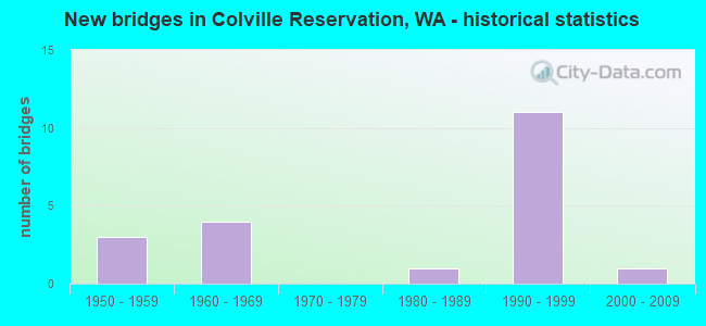
- New bridges - historical statistics
- 31950-1959
- 41960-1969
- 11980-1989
- 111990-1999
- 12000-2009


- Bridge Condition - Deck
- 16.7%Good
- 75.0%Satisfactory
- 8.3%Fair

- Bridge Condition - Superstructure
- 33.3%Good
- 58.3%Satisfactory
- 8.3%Fair

- Bridge Condition - Substructure
- 16.7%Good
- 58.3%Satisfactory
- 16.7%Poor
- 8.3%Critical

- Bridge Condition - Channel
- 35.0%Very good
- 10.0%Good
- 35.0%Satisfactory
- 10.0%Fair
- 10.0%Serious

- Bridge Condition - Culverts
- 50.0%Good
- 12.5%Satisfactory
- 37.5%Fair
Find on map >> Show street view
Structure Number: P311, Location: 16 KM SOUTH OF REPUBLIC (Lat: 48.416514, Lng: -118.736197), Route carried "on" structure: Federal lands road 98, Year Built: 1959, Status: Open, Structure Length: 2.98m (9.78ft), Average Daily Traffic: 50 (year 2021), Truck Traffic: 20%, Average Future Daily Traffic: 100 (year 2041), Features Intersected: SAN POIL RIVER
Minimum Vertical Clearance: 30+ m (98+ ft), Kilometerpoint: 0.483, Lanes on structure: 1, Owner: Bureau of Indian Affairs, Approaching Roadway Width: 4.9m (16.1ft), Material/Design: Concrete, Design/Construction: Slab, Number Of Spans In Main Unit: 3, Length of Maximum Span: 11.1m (36.4ft), Curb or Sidewalk Widths: Left: 0.4m (1.3ft), Right: 0.4m (1.3ft), Curb-To-Curb Width: 4.3m (14.1ft), Out-to-Out Width: 4.8m (15.7ft)
Condition: Deck: Satisfactory, Superstructure: Satisfactory, Substructure: Poor, Channel: Serious, Operating Rating: 52.3 metric tons, Method Used To Determine Operating Rating: Load Factor (LF), Inventory Rating: 31.3 metric tons, Method Used To Determine Inventory Rating: Load Factor (LF), Structural Evaluation: Meets minimum limits, Deck Geometry: Equal to present minimum criteria, Waterway Adequacy: Better than present minimum criteria, Approach Roadway Alignment: Equal to present minimum criteria, Length Of Structure Improvement: 5.00m (16.40ft), Designated Inspection Frequency: Every 24 months, Inspection Date: July 2021, Total Project Cost: $34,000 ( Estimate for 2021), Deck Structure Type: Concrete Cast-file-Place
Find on map >> Show street view
Structure Number: P312, Location: 11 KM S.W. OF REPUBLIC (Lat: 48.456242, Lng: -118.801747), Route carried "on" structure: Federal lands road 6, Year Built: 1962, Status: Open, Structure Length: 1.60m (5.25ft), Average Daily Traffic: 300 (year 2021), Truck Traffic: 15%, Average Future Daily Traffic: 600 (year 2041), Design Load: HS 15, Features Intersected: WEST FORK SAN POIL RIVER
Minimum Vertical Clearance: 30+ m (98+ ft), Kilometerpoint: 39.300, Lanes on structure: 2, Owner: Bureau of Indian Affairs, Approaching Roadway Width: 6.4m (21.0ft), Material/Design: Concrete, Design/Construction: Tee Beam, Number Of Spans In Main Unit: 2, Length of Maximum Span: 7.6m (24.9ft), Curb or Sidewalk Widths: Left: 0.4m (1.3ft), Right: 0.4m (1.3ft), Curb-To-Curb Width: 7.3m (24.0ft), Out-to-Out Width: 8.1m (26.6ft)
Condition: Deck: Satisfactory, Superstructure: Satisfactory, Substructure: Satisfactory, Channel: Very good, Operating Rating: 43.5 metric tons, Method Used To Determine Operating Rating: No rating analysis performed, Inventory Rating: 32.7 metric tons, Method Used To Determine Inventory Rating: No rating analysis performed, Structural Evaluation: Equal to present minimum criteria, Deck Geometry: Somewhat better than minimum adequacy, Waterway Adequacy: Better than present minimum criteria, Approach Roadway Alignment: Equal to present minimum criteria, Designated Inspection Frequency: Every 24 months, Inspection Date: July 2021, Total Project Cost: $50,000 ( Estimate for 2021), Deck Structure Type: Concrete Cast-file-Place, Wearing Surface/Protective System: Wearing Surface: Monolithic Concrete
Find on map >> Show street view
Structure Number: P322, Location: 6 KM NW OF NINE MILE (Lat: 48.084544, Lng: -118.467500), Route carried "on" structure: Federal lands road 100, Year Built: 1962, Status: Open, Structure Length: 1.58m (5.18ft), Average Daily Traffic: 50 (year 2021), Truck Traffic: 10%, Average Future Daily Traffic: 75 (year 2041), Design Load: HS 20, Features Intersected: NINE MILE CREEK
Minimum Vertical Clearance: 30+ m (98+ ft), Kilometerpoint: 1.600, Lanes on structure: 2, Owner: Bureau of Indian Affairs, Approaching Roadway Width: 9.1m (29.9ft), Material/Design: Concrete, Design/Construction: Stringer/Multi-beam, Number Of Spans In Main Unit: 2, Length of Maximum Span: 7.6m (24.9ft), Curb or Sidewalk Widths: Left: 0.4m (1.3ft), Right: 0.4m (1.3ft), Curb-To-Curb Width: 7.3m (24.0ft), Out-to-Out Width: 8.2m (26.9ft)
Condition: Deck: Satisfactory, Superstructure: Fair, Substructure: Satisfactory, Channel: Good, Operating Rating: 43.2 metric tons, Method Used To Determine Operating Rating: No rating analysis performed, Inventory Rating: 32.4 metric tons, Method Used To Determine Inventory Rating: No rating analysis performed, Structural Evaluation: Somewhat better than minimum adequacy, Deck Geometry: Equal to present minimum criteria, Waterway Adequacy: Better than present minimum criteria, Approach Roadway Alignment: Equal to present minimum criteria, Designated Inspection Frequency: Every 24 months, Inspection Date: July 2021, Deck Structure Type: Concrete Cast-file-Place
Find on map >> Show street view
Structure Number: P332, Location: 18 KM NW OF SUB-AGENCY (Lat: 48.413556, Lng: -118.377022), Route carried "on" structure: Federal lands road 14, Year Built: 1992, Status: Open, Structure Length: 1.24m (4.07ft), Average Daily Traffic: 50 (year 2021), Truck Traffic: 40%, Average Future Daily Traffic: 100 (year 2041), Design Load: HS 20+Mod, Features Intersected: HALL CREEK, Facility Carried by Structure: IRR BIA RTE 1123
Minimum Vertical Clearance: 30+ m (98+ ft), Kilometerpoint: 0.300, Lanes on structure: 1, Owner: Bureau of Indian Affairs, Approaching Roadway Width: 4.6m (15.1ft), Material/Design: Steel, Design/Construction: Stringer/Multi-beam, Number Of Spans In Main Unit: 1, Length of Maximum Span: 11.9m (39.0ft), Curb-To-Curb Width: 4.3m (14.1ft), Out-to-Out Width: 4.4m (14.4ft)
Condition: Deck: Satisfactory, Superstructure: Good, Substructure: Satisfactory, Channel: Serious, Operating Rating: 36.5 metric tons, Method Used To Determine Operating Rating: No rating analysis performed, Inventory Rating: 26.7 metric tons, Method Used To Determine Inventory Rating: No rating analysis performed, Structural Evaluation: Equal to present minimum criteria, Deck Geometry: Equal to present minimum criteria, Waterway Adequacy: Equal to present minimum criteria, Approach Roadway Alignment: Meets minimum limits, Designated Inspection Frequency: Every 24 months, Inspection Date: July 2021, Deck Structure Type: Corrugated Steel, Wearing Surface/Protective System: Wearing Surface: Gravel
Find on map >> Show street view
Structure Number: P333, Location: 25 KM NW OF SUB-AGENCY (Lat: 48.403806, Lng: -118.458675), Route carried "on" structure: Federal lands road 1123, Year Built: 1993, Status: Posted for load, Structure Length: 1.34m (4.40ft), Average Daily Traffic: 50 (year 2021), Truck Traffic: 40%, Average Future Daily Traffic: 100 (year 2041), Design Load: HS 20+Mod, Features Intersected: SITDOWN CREEK
Minimum Vertical Clearance: 30+ m (98+ ft), Kilometerpoint: 6.900, Lanes on structure: 1, Owner: Bureau of Indian Affairs, Approaching Roadway Width: 4.6m (15.1ft), Material/Design: Steel, Design/Construction: Stringer/Multi-beam, Number Of Spans In Main Unit: 1, Length of Maximum Span: 13.1m (43.0ft), Curb-To-Curb Width: 4.3m (14.1ft), Out-to-Out Width: 4.3m (14.1ft)
Condition: Deck: Satisfactory, Superstructure: Good, Substructure: Poor, Channel: Fair, Operating Rating: 77.1 metric tons, Method Used To Determine Operating Rating: No rating analysis performed, Inventory Rating: 46.2 metric tons, Method Used To Determine Inventory Rating: No rating analysis performed, Structural Evaluation: Meets minimum limits, Deck Geometry: Equal to present minimum criteria, Waterway Adequacy: Equal to present minimum criteria, Approach Roadway Alignment: Equal to present minimum criteria, Bridge Posting: Required (Relationship of Operating Rating to Maximum Legal Load: 10.0 - 19.9% below), Designated Inspection Frequency: Every 24 months, Inspection Date: July 2021, Total Project Cost: $102,000 ( Estimate for 2021), Deck Structure Type: Corrugated Steel, Wearing Surface/Protective System: Wearing Surface: Gravel
Find on map >> Show street view
Structure Number: P334, Location: 26 KM NW OF SUB-AGENCY (Lat: 48.397964, Lng: -118.473086), Route carried "on" structure: Federal lands road 1123, Year Built: 1993, Status: Open, Structure Length: 1.23m (4.04ft), Average Daily Traffic: 50 (year 2021), Truck Traffic: 40%, Average Future Daily Traffic: 100 (year 2041), Design Load: HS 20+Mod, Features Intersected: SITDOWN CREEK
Minimum Vertical Clearance: 30+ m (98+ ft), Kilometerpoint: 8.207, Lanes on structure: 1, Owner: Bureau of Indian Affairs, Approaching Roadway Width: 4.6m (15.1ft), Material/Design: Steel, Design/Construction: Stringer/Multi-beam, Number Of Spans In Main Unit: 1, Length of Maximum Span: 11.9m (39.0ft), Curb-To-Curb Width: 4.3m (14.1ft), Out-to-Out Width: 4.3m (14.1ft)
Condition: Deck: Satisfactory, Superstructure: Good, Substructure: Satisfactory, Channel: Satisfactory, Operating Rating: 36.5 metric tons, Method Used To Determine Operating Rating: No rating analysis performed, Inventory Rating: 26.7 metric tons, Method Used To Determine Inventory Rating: No rating analysis performed, Structural Evaluation: Equal to present minimum criteria, Deck Geometry: Equal to present minimum criteria, Waterway Adequacy: Better than present minimum criteria, Approach Roadway Alignment: Equal to present minimum criteria, Length Of Structure Improvement: 8.00m (26.25ft), Designated Inspection Frequency: Every 24 months, Inspection Date: July 2021, Total Project Cost: $29,000 ( Estimate for 2021), Deck Structure Type: Corrugated Steel, Wearing Surface/Protective System: Wearing Surface: Gravel
Find on map >> Show street view
Structure Number: P335, Location: 26.9 KM NW OF SUB-AGENCY (Lat: 48.393936, Lng: -118.481678), Route carried "on" structure: Federal lands road 1123, Year Built: 1993, Status: Open, Structure Length: 1.23m (4.04ft), Average Daily Traffic: 50 (year 2021), Truck Traffic: 40%, Average Future Daily Traffic: 100 (year 2041), Design Load: HS 20+Mod, Features Intersected: SITDOWN CREEK
Minimum Vertical Clearance: 30+ m (98+ ft), Kilometerpoint: 9.000, Lanes on structure: 1, Owner: Bureau of Indian Affairs, Approaching Roadway Width: 4.9m (16.1ft), Material/Design: Steel, Design/Construction: Stringer/Multi-beam, Number Of Spans In Main Unit: 1, Length of Maximum Span: 11.6m (38.1ft), Curb-To-Curb Width: 4.3m (14.1ft), Out-to-Out Width: 4.3m (14.1ft)
Condition: Deck: Satisfactory, Superstructure: Satisfactory, Substructure: Satisfactory, Channel: Satisfactory, Operating Rating: 37.2 metric tons, Method Used To Determine Operating Rating: No rating analysis performed, Inventory Rating: 27.2 metric tons, Method Used To Determine Inventory Rating: No rating analysis performed, Structural Evaluation: Equal to present minimum criteria, Deck Geometry: Equal to present minimum criteria, Waterway Adequacy: Better than present minimum criteria, Approach Roadway Alignment: Equal to present desirable criteria, Designated Inspection Frequency: Every 24 months, Inspection Date: July 2021, Total Project Cost: $99,000 ( Estimate for 2021), Deck Structure Type: Corrugated Steel, Wearing Surface/Protective System: Wearing Surface: Gravel
Find on map >> Show street view
Structure Number: P336, Location: 4.8 KM E OF COLVILLE AGCY (Lat: 48.136561, Lng: -118.921844), Route carried "on" structure: Federal lands road 74, Year Built: 1994, Status: Posted for load, Structure Length: 0.82m (2.69ft), Average Daily Traffic: 20 (year 2021), Truck Traffic: 5%, Average Future Daily Traffic: 30 (year 2041), Design Load: HS 20, Features Intersected: LITTLE NESPELEM RIVER
Minimum Vertical Clearance: 30+ m (98+ ft), Kilometerpoint: 0.200, Lanes on structure: 1, Owner: Bureau of Indian Affairs, Approaching Roadway Width: 4.9m (16.1ft), Material/Design: Steel, Design/Construction: Culvert, Number Of Spans In Main Unit: 2, Length of Maximum Span: 3.5m (11.5ft), Curb-To-Curb Width: 4.9m (16.1ft), Out-to-Out Width: 4.9m (16.1ft)
Condition: Channel: Satisfactory, Culverts: Fair, Operating Rating: 25.4 metric tons, Method Used To Determine Operating Rating: Allowable Stress (AS), Inventory Rating: 19.1 metric tons, Method Used To Determine Inventory Rating: Allowable Stress (AS), Structural Evaluation: Somewhat better than minimum adequacy, Deck Geometry: High priority of corrective action, Waterway Adequacy: Better than present minimum criteria, Approach Roadway Alignment: Somewhat better than minimum adequacy, Bridge Posting: Required (Relationship of Operating Rating to Maximum Legal Load: 0.1 - 9.9% below), Designated Inspection Frequency: Every 24 months, Inspection Date: July 2021, Total Project Cost: $77,000 ( Estimate for 2021)
Find on map >> Show street view
Structure Number: P337, Location: 8.1 KM E OF COLVILLE AGCY (Lat: 48.142931, Lng: -118.884656), Route carried "on" structure: Federal lands road 74, Year Built: 1994, Status: Posted for load, Structure Length: 0.85m (2.79ft), Average Daily Traffic: 10 (year 2021), Truck Traffic: 10%, Average Future Daily Traffic: 20 (year 2041), Design Load: HS 15, Features Intersected: LITTLE NESPELEM RIVER
Minimum Vertical Clearance: 30+ m (98+ ft), Kilometerpoint: 4.300, Lanes on structure: 1, Owner: Bureau of Indian Affairs, Approaching Roadway Width: 3.3m (10.8ft), Skew: 1 degrees, Material/Design: Steel, Design/Construction: Culvert, Number Of Spans In Main Unit: 2, Length of Maximum Span: 3.4m (11.2ft), Curb-To-Curb Width: 3.3m (10.8ft), Out-to-Out Width: 3.3m (10.8ft)
Condition: Channel: Very good, Culverts: Fair, Operating Rating: 25.4 metric tons, Method Used To Determine Operating Rating: Allowable Stress (AS), Inventory Rating: 19.0 metric tons, Method Used To Determine Inventory Rating: Allowable Stress (AS), Structural Evaluation: Somewhat better than minimum adequacy, Deck Geometry: High priority of replacement, Waterway Adequacy: Better than present minimum criteria, Approach Roadway Alignment: Equal to present minimum criteria, Bridge Posting: Required (Relationship of Operating Rating to Maximum Legal Load: 0.1 - 9.9% below), Designated Inspection Frequency: Every 24 months, Inspection Date: July 2021, Total Project Cost: $55,000 ( Estimate for 2021)
Find on map >> Show street view
Structure Number: P339, Location: 0.6 KM WEST OF AGENCY (Lat: 48.136022, Lng: -118.985475), Route carried "on" structure: Federal lands road 1167, Year Built: 1957, Status: Open, Structure Length: 3.20m (10.50ft), Average Daily Traffic: 250 (year 2021), Truck Traffic: 15%, Average Future Daily Traffic: 500 (year 2041), Design Load: HS 20, Features Intersected: NESPELEM RIVER
Minimum Vertical Clearance: 30+ m (98+ ft), Kilometerpoint: 0.600, Lanes on structure: 2, Owner: Bureau of Indian Affairs, Approaching Roadway Width: 7.2m (23.6ft), Material/Design: Concrete, Design/Construction: Slab, Number Of Spans In Main Unit: 3, Length of Maximum Span: 11.4m (37.4ft), Curb or Sidewalk Widths: Left: 0.4m (1.3ft), Right: 0.4m (1.3ft), Curb-To-Curb Width: 7.3m (24.0ft), Out-to-Out Width: 8.1m (26.6ft)
Condition: Deck: Satisfactory, Superstructure: Satisfactory, Substructure: Good, Channel: Satisfactory, Operating Rating: 43.5 metric tons, Method Used To Determine Operating Rating: No rating analysis performed, Inventory Rating: 32.7 metric tons, Method Used To Determine Inventory Rating: No rating analysis performed, Structural Evaluation: Equal to present minimum criteria, Deck Geometry: Somewhat better than minimum adequacy, Waterway Adequacy: Equal to present minimum criteria, Approach Roadway Alignment: Equal to present desirable criteria, Designated Inspection Frequency: Every 24 months, Inspection Date: July 2021, Deck Structure Type: Concrete Cast-file-Place, Wearing Surface/Protective System: Wearing Surface: Monolithic Concrete
Find on map >> Show street view
Structure Number: P34, Location: 13 KM NORTH OF NESPELEM (Lat: 48.338467, Lng: -118.977867), Route carried "on" structure: Federal lands road 116, Year Built: 1998, Status: Open, Structure Length: 0.85m (2.79ft), Average Daily Traffic: 50 (year 2021), Truck Traffic: 30%, Average Future Daily Traffic: 100 (year 2041), Design Load: HS 25 or greater, Features Intersected: STEPSTONE CREEK
Minimum Vertical Clearance: 30+ m (98+ ft), Kilometerpoint: 4.500, Lanes on structure: 2, Owner: Bureau of Indian Affairs, Approaching Roadway Width: 7.0m (23.0ft), Material/Design: Steel, Design/Construction: Culvert, Number Of Spans In Main Unit: 1, Length of Maximum Span: 8.1m (26.6ft), Curb-To-Curb Width: 7.0m (23.0ft), Out-to-Out Width: 7.0m (23.0ft)
Condition: Channel: Very good, Culverts: Fair, Operating Rating: 65.9 metric tons, Method Used To Determine Operating Rating: Load Testing, Inventory Rating: 50.7 metric tons, Method Used To Determine Inventory Rating: Load Testing, Structural Evaluation: Somewhat better than minimum adequacy, Deck Geometry: Somewhat better than minimum adequacy, Waterway Adequacy: Superior to present desirable criteria, Approach Roadway Alignment: Equal to present minimum criteria, Designated Inspection Frequency: Every 24 months, Inspection Date: July 2021, Wearing Surface/Protective System: Wearing Surface: Gravel
Find on map >> Show street view
Structure Number: 82777, Location: 00.03 E SR 21 (Lat: 48.083192, Lng: -118.690264), Route carried "on" structure: County highway 670, Year Built: 1961, Status: Open, Structure Length: 4.45m (14.60ft), Average Daily Traffic: 325 (year 2018), Truck Traffic: 15%, Average Future Daily Traffic: 610 (year 2038), Design Load: HS 15, Features Intersected: SAN POIL RIVER
Minimum Vertical Clearance: 30+ m (98+ ft), Kilometerpoint: 0.001, Lanes on structure: 2, Owner: County Highway Agency, Approaching Roadway Width: 7.3m (24.0ft), Material/Design: Concrete continuous, Design/Construction: Stringer/Multi-beam, Number Of Spans In Main Unit: 3, Length of Maximum Span: 18.3m (60.0ft), Curb-To-Curb Width: 7.4m (24.3ft), Out-to-Out Width: 7.9m (25.9ft)
Condition: Deck: Good, Superstructure: Satisfactory, Substructure: Satisfactory, Channel: Satisfactory, Operating Rating: 28.8 metric tons, Method Used To Determine Operating Rating: Load and Resistance Factor Rating (LRFR) rating reported by rating factor(RF) method using HL-93 loadings, Inventory Rating: 22.4 metric tons, Method Used To Determine Inventory Rating: Load and Resistance Factor Rating (LRFR) rating reported by rating factor(RF) method using HL-93 loadings, Structural Evaluation: Equal to present minimum criteria, Deck Geometry: Somewhat better than minimum adequacy, Waterway Adequacy: Equal to present minimum criteria, Approach Roadway Alignment: High priority of corrective action, Length Of Structure Improvement: 4.75m (15.58ft), Designated Inspection Frequency: Every 24 months, Inspection Date: June 2020, Bridge Improvement Cost: $2,371,000, Roadway Improvement Cost: $474,000, Total Project Cost: $4,742,000 ( Estimate for 2014), Deck Structure Type: Concrete Cast-file-Place, Wearing Surface/Protective System: Wearing Surface: Bituminous
Find on map >> Show street view
Structure Number: 84149, Location: 19.05 E SR 21 (Lat: 48.070325, Lng: -118.455739), Route carried "on" structure: County highway 670, Year Built: 1958, Status: Posted for load, Structure Length: 1.55m (5.09ft), Average Daily Traffic: 445 (year 2018), Truck Traffic: 20%, Average Future Daily Traffic: 600 (year 2040), Design Load: HS 15, Features Intersected: NINE MILE CREEK
Minimum Vertical Clearance: 30+ m (98+ ft), Kilometerpoint: 0.001, Lanes on structure: 2, Owner: County Highway Agency, Approaching Roadway Width: 8.5m (27.9ft), Material/Design: Concrete, Design/Construction: Stringer/Multi-beam, Number Of Spans In Main Unit: 2, Length of Maximum Span: 7.6m (24.9ft), Curb-To-Curb Width: 7.3m (24.0ft), Out-to-Out Width: 8.1m (26.6ft)
Condition: Deck: Fair, Superstructure: Satisfactory, Substructure: Critical, Channel: Fair, Operating Rating: 4.5 metric tons, Method Used To Determine Operating Rating: Field evaluation and documented engineering judgment, Inventory Rating: 2.7 metric tons, Method Used To Determine Inventory Rating: Field evaluation and documented engineering judgment, Structural Evaluation: High priority of replacement, Deck Geometry: Meets minimum limits, Waterway Adequacy: Better than present minimum criteria, Approach Roadway Alignment: Equal to present desirable criteria, Bridge Posting: Required (Relationship of Operating Rating to Maximum Legal Load: > 39.9% below), Length Of Structure Improvement: 1.86m (6.10ft), Designated Inspection Frequency: Every 12 months, Inspection Date: June 2021, Bridge Improvement Cost: $927,000, Roadway Improvement Cost: $185,000, Total Project Cost: $1,854,000 ( Estimate for 2014), Deck Structure Type: Concrete Cast-file-Place, Wearing Surface/Protective System: Wearing Surface: Monolithic Concrete
Find on map >> Show street view
Structure Number: 84167, Location: 00.2 E JCT SR 21 (Lat: 48.228433, Lng: -118.699333), Route carried "on" structure: County highway 20, Year Built: 1960, Status: Open, Structure Length: 3.35m (10.99ft), Average Daily Traffic: 290 (year 2018), Truck Traffic: 10%, Average Future Daily Traffic: 355 (year 2038), Design Load: HS 15, Features Intersected: SAN POIL RIVER, Facility Carried by Structure: BRIDGE CR ROAD
Minimum Vertical Clearance: 30+ m (98+ ft), Kilometerpoint: 0.001, Lanes on structure: 2, Owner: County Highway Agency, Approaching Roadway Width: 9.1m (29.9ft), Material/Design: Concrete continuous, Design/Construction: Tee Beam, Number Of Spans In Main Unit: 3, Length of Maximum Span: 13.4m (44.0ft), Curb-To-Curb Width: 7.3m (24.0ft), Out-to-Out Width: 8.1m (26.6ft)
Condition: Deck: Good, Superstructure: Good, Substructure: Satisfactory, Channel: Good, Operating Rating: 25.6 metric tons, Method Used To Determine Operating Rating: Load and Resistance Factor Rating (LRFR) rating reported by rating factor(RF) method using HL-93 loadings, Inventory Rating: 19.8 metric tons, Method Used To Determine Inventory Rating: Load and Resistance Factor Rating (LRFR) rating reported by rating factor(RF) method using HL-93 loadings, Structural Evaluation: Somewhat better than minimum adequacy, Deck Geometry: Somewhat better than minimum adequacy, Waterway Adequacy: Somewhat better than minimum adequacy, Approach Roadway Alignment: Equal to present desirable criteria, Designated Inspection Frequency: Every 24 months, Inspection Date: June 2020, Deck Structure Type: Concrete Cast-file-Place, Wearing Surface/Protective System: Wearing Surface: Bituminous
Find on map >> Show street view
Structure Number: 85718, Location: 00.02 W HALL CRK RD (Lat: 48.345386, Lng: -118.262453), Route carried "on" structure: County highway 940, Year Built: 1989, Status: Open, Structure Length: 1.62m (5.31ft), Average Daily Traffic: 93 (year 2015), Truck Traffic: 10%, Average Future Daily Traffic: 200 (year 2040), Design Load: HS 20, Features Intersected: HALL CREEK, Facility Carried by Structure: LYNX CREEK ROAD
Minimum Vertical Clearance: 30+ m (98+ ft), Kilometerpoint: 0.001, Lanes on structure: 2, Owner: County Highway Agency, Approaching Roadway Width: 8.2m (26.9ft), Material/Design: Prestressed concrete, Design/Construction: Stringer/Multi-beam, Number Of Spans In Main Unit: 1, Length of Maximum Span: 15.8m (51.8ft), Curb-To-Curb Width: 7.3m (24.0ft), Out-to-Out Width: 8.3m (27.2ft)
Condition: Deck: Satisfactory, Superstructure: Satisfactory, Substructure: Good, Channel: Very good, Operating Rating: 55.1 metric tons, Method Used To Determine Operating Rating: Load and Resistance Factor Rating (LRFR) rating reported by rating factor(RF) method using HL-93 loadings, Inventory Rating: 36.9 metric tons, Method Used To Determine Inventory Rating: Load and Resistance Factor Rating (LRFR) rating reported by rating factor(RF) method using HL-93 loadings, Structural Evaluation: Equal to present minimum criteria, Deck Geometry: Equal to present minimum criteria, Waterway Adequacy: Better than present minimum criteria, Approach Roadway Alignment: Equal to present minimum criteria, Designated Inspection Frequency: Every 24 months, Inspection Date: June 2021, Deck Structure Type: Other, Wearing Surface/Protective System: Wearing Surface: Monolithic Concrete
Find on map >> Show street view
Structure Number: 86458, Location: 12.65 W LYNX CRK RD (Lat: 48.452069, Lng: -118.452325), Route carried "on" structure: ServiceCounty highway 990, Year Built: 1999, Status: Open, Structure Length: 0.88m (2.89ft), Average Daily Traffic: 10 (year 2015), Truck Traffic: 25%, Average Future Daily Traffic: 15 (year 2040), Design Load: HS 20, Features Intersected: HALL CREEK, Facility Carried by Structure: HALL CREEK RD
Minimum Vertical Clearance: 30+ m (98+ ft), Kilometerpoint: 0.001, Lanes on structure: 2, Owner: County Highway Agency, Approaching Roadway Width: 5.5m (18.0ft), Skew: 3 degrees, Material/Design: Steel, Design/Construction: Culvert, Number Of Spans In Main Unit: 1, Length of Maximum Span: 8.8m (28.9ft)
Condition: Channel: Satisfactory, Culverts: Satisfactory, Operating Rating: 96.9 metric tons, Method Used To Determine Operating Rating: Load and Resistance Factor Rating (LRFR) rating reported by rating factor(RF) method using HL-93 loadings, Inventory Rating: 96.9 metric tons, Method Used To Determine Inventory Rating: Load and Resistance Factor Rating (LRFR) rating reported by rating factor(RF) method using HL-93 loadings, Structural Evaluation: Equal to present minimum criteria, Waterway Adequacy: Equal to present desirable criteria, Approach Roadway Alignment: Equal to present minimum criteria, Length Of Structure Improvement: 0.98m (3.22ft), Designated Inspection Frequency: Every 24 months, Inspection Date: June 2021, Bridge Improvement Cost: $60,000, Roadway Improvement Cost: $20,000, Total Project Cost: $80,000
Find on map >> Show street view
Structure Number: 86459, Location: 12.92 W LYNCRK RD (Lat: 48.453428, Lng: -118.457217), Route carried "on" structure: ServiceCounty highway 990, Year Built: 1999, Status: Open, Structure Length: 0.76m (2.49ft), Average Daily Traffic: 10 (year 2015), Truck Traffic: 25%, Average Future Daily Traffic: 15 (year 2040), Design Load: HS 20, Features Intersected: HALL CREEK, Facility Carried by Structure: HALL CREEK RD
Minimum Vertical Clearance: 30+ m (98+ ft), Kilometerpoint: 0.001, Lanes on structure: 2, Owner: County Highway Agency, Approaching Roadway Width: 5.5m (18.0ft), Skew: 1 degrees, Material/Design: Steel, Design/Construction: Culvert, Number Of Spans In Main Unit: 1, Length of Maximum Span: 7.6m (24.9ft)
Condition: Channel: Very good, Culverts: Good, Operating Rating: 96.9 metric tons, Method Used To Determine Operating Rating: Load and Resistance Factor Rating (LRFR) rating reported by rating factor(RF) method using HL-93 loadings, Inventory Rating: 96.9 metric tons, Method Used To Determine Inventory Rating: Load and Resistance Factor Rating (LRFR) rating reported by rating factor(RF) method using HL-93 loadings, Structural Evaluation: Better than present minimum criteria, Waterway Adequacy: Equal to present desirable criteria, Approach Roadway Alignment: Equal to present desirable criteria, Length Of Structure Improvement: 0.82m (2.69ft), Designated Inspection Frequency: Every 24 months, Inspection Date: June 2021, Bridge Improvement Cost: $60,000, Roadway Improvement Cost: $20,000, Total Project Cost: $80,000
Find on map >> Show street view
Structure Number: 8646, Location: 13.60 W LYNX CRK RD (Lat: 48.457906, Lng: -118.470008), Route carried "on" structure: ServiceCounty highway 990, Year Built: 1999, Status: Open, Structure Length: 0.76m (2.49ft), Average Daily Traffic: 10 (year 2015), Truck Traffic: 25%, Average Future Daily Traffic: 15 (year 2040), Design Load: HS 20, Features Intersected: HALL CREEK, Facility Carried by Structure: HALL CREEK RD
Minimum Vertical Clearance: 30+ m (98+ ft), Kilometerpoint: 0.001, Lanes on structure: 2, Owner: County Highway Agency, Approaching Roadway Width: 5.5m (18.0ft), Material/Design: Steel, Design/Construction: Culvert, Number Of Spans In Main Unit: 1, Length of Maximum Span: 7.6m (24.9ft)
Condition: Channel: Satisfactory, Culverts: Good, Operating Rating: 96.9 metric tons, Method Used To Determine Operating Rating: Load and Resistance Factor Rating (LRFR) rating reported by rating factor(RF) method using HL-93 loadings, Inventory Rating: 96.9 metric tons, Method Used To Determine Inventory Rating: Load and Resistance Factor Rating (LRFR) rating reported by rating factor(RF) method using HL-93 loadings, Structural Evaluation: Better than present minimum criteria, Waterway Adequacy: Equal to present desirable criteria, Approach Roadway Alignment: High priority of corrective action, Length Of Structure Improvement: 0.82m (2.69ft), Designated Inspection Frequency: Every 24 months, Inspection Date: June 2021, Bridge Improvement Cost: $60,000, Roadway Improvement Cost: $20,000, Total Project Cost: $80,000
Find on map >> Show street view
Structure Number: 86461, Location: 15.16 W LYNX CRK RD (Lat: 48.460611, Lng: -118.489700), Route carried "on" structure: ServiceCounty highway 990, Year Built: 1999, Status: Open, Structure Length: 0.76m (2.49ft), Average Daily Traffic: 10 (year 2015), Truck Traffic: 25%, Average Future Daily Traffic: 15 (year 2040), Design Load: HS 20, Features Intersected: HALL CREEK, Facility Carried by Structure: HALL CREEK RD
Minimum Vertical Clearance: 30+ m (98+ ft), Kilometerpoint: 0.001, Lanes on structure: 2, Owner: County Highway Agency, Approaching Roadway Width: 5.5m (18.0ft), Skew: 1 degrees, Material/Design: Steel, Design/Construction: Culvert, Number Of Spans In Main Unit: 1, Length of Maximum Span: 7.6m (24.9ft)
Condition: Channel: Very good, Culverts: Good, Operating Rating: 96.9 metric tons, Method Used To Determine Operating Rating: Load and Resistance Factor Rating (LRFR) rating reported by rating factor(RF) method using HL-93 loadings, Inventory Rating: 96.9 metric tons, Method Used To Determine Inventory Rating: Load and Resistance Factor Rating (LRFR) rating reported by rating factor(RF) method using HL-93 loadings, Structural Evaluation: Better than present minimum criteria, Waterway Adequacy: Equal to present desirable criteria, Approach Roadway Alignment: High priority of corrective action, Length Of Structure Improvement: 0.82m (2.69ft), Designated Inspection Frequency: Every 24 months, Inspection Date: June 2021, Bridge Improvement Cost: $60,000, Roadway Improvement Cost: $20,000, Total Project Cost: $80,000
Find on map >> Show street view
Structure Number: 87049, Location: 25.25 E SR21 (Lat: 48.293272, Lng: -118.306975), Route carried "on" structure: County highway 20, Year Built: 2000, Status: Open, Structure Length: 0.73m (2.40ft), Average Daily Traffic: 1,493 (year 2021), Truck Traffic: 5%, Average Future Daily Traffic: 2,500 (year 2040), Design Load: HS 20, Features Intersected: CORNSTALK CREEK, Facility Carried by Structure: BRIDGE CREEK ROAD
Minimum Vertical Clearance: 30+ m (98+ ft), Kilometerpoint: 0.001, Lanes on structure: 2, Owner: County Highway Agency, Approaching Roadway Width: 7.3m (24.0ft), Skew: 3 degrees, Material/Design: Aluminum, Iron, Design/Construction: Culvert, Number Of Spans In Main Unit: 1, Length of Maximum Span: 3.4m (11.2ft)
Condition: Channel: Very good, Culverts: Good, Operating Rating: 27.2 metric tons, Method Used To Determine Operating Rating: Load and Resistance Factor Rating (LRFR) rating reported by rating factor(RF) method using HL-93 loadings, Inventory Rating: 21.1 metric tons, Method Used To Determine Inventory Rating: Load and Resistance Factor Rating (LRFR) rating reported by rating factor(RF) method using HL-93 loadings, Structural Evaluation: Somewhat better than minimum adequacy, Waterway Adequacy: Better than present minimum criteria, Approach Roadway Alignment: Equal to present desirable criteria, Length Of Structure Improvement: 1.04m (3.41ft), Designated Inspection Frequency: Every 24 months, Inspection Date: June 2021, Bridge Improvement Cost: $517,000, Roadway Improvement Cost: $103,000, Total Project Cost: $1,034,000 ( Estimate for 2014)