Bridge Statistics for Crestwood, Kentucky (KY)
Condition, Traffic, Stress, Structural Evaluation, Project Costs
- National Bridge Inventory (NBI) Statistics
- 16Number of bridges
- 138ft / 42.3mTotal length
- 271,722Total average daily traffic
- 45,272Total average daily truck traffic
- National Bridge Inventory (NBI) Registered Bridges for Crestwood
- No street view available for this location
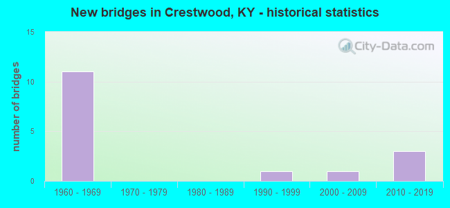
- New bridges - historical statistics
- 111960-1969
- 11990-1999
- 12000-2009
- 32010-2019


- Bridge Condition - Deck
- 28.6%Good
- 28.6%Satisfactory
- 42.9%Fair

- Bridge Condition - Superstructure
- 28.6%Very good
- 71.4%Satisfactory

- Bridge Condition - Substructure
- 42.9%Good
- 57.1%Satisfactory

- Bridge Condition - Channel
- 33.3%Good
- 44.4%Satisfactory
- 22.2%Fair

- Bridge Condition - Culverts
- 60.0%Satisfactory
- 20.0%Fair
- 20.0%Poor
Find on map >> Show street view
Structure Number: 93B00020N, Location: 0.40 MI N OF KY 1818 (Lat: 38.307500, Lng: -85.450556), Route carried "on" structure: State highway 1408, Year Built: 1963, Status: Open, Structure Length: 4.39m (14.40ft), Average Daily Traffic: 2,906 (year 2020), Truck Traffic: 6%, Average Future Daily Traffic: 2,702 (year 2040), Design Load: H 15, Features Intersected: CURRYS FORK
Minimum Vertical Clearance: 30+ m (98+ ft), Kilometerpoint: 2.306, Lanes on structure: 2, Owner: State Highway Agency, Approaching Roadway Width: 7.0m (23.0ft), Skew: 3 degrees, Material/Design: Concrete, Design/Construction: Tee Beam, Number Of Spans In Main Unit: 3, Length of Maximum Span: 14.9m (48.9ft), Curb or Sidewalk Widths: Left: 0.3m (1.0ft), Right: 0.3m (1.0ft), Curb-To-Curb Width: 7.9m (25.9ft), Out-to-Out Width: 9.2m (30.2ft)
Condition: Deck: Fair, Superstructure: Satisfactory, Substructure: Satisfactory, Channel: Fair, Operating Rating: 66.6 metric tons, Method Used To Determine Operating Rating: Load Factor (LF), Inventory Rating: 39.9 metric tons, Method Used To Determine Inventory Rating: Load Factor (LF), Structural Evaluation: Equal to present minimum criteria, Deck Geometry: High priority of corrective action, Waterway Adequacy: Equal to present desirable criteria, Approach Roadway Alignment: Equal to present desirable criteria, Designated Inspection Frequency: Every 24 months, Inspection Date: March 2021, Deck Structure Type: Concrete Cast-file-Place, Wearing Surface/Protective System: Wearing Surface: Latex Concrete
Find on map >> Show street view
Structure Number: 93B00030R, Location: 3.0 MI S OF KY 146 NTRCH (Lat: 38.346667, Lng: -85.491389), Route carried "on" structure: Interstate 71, Year Built: 1968, Status: Open, Structure Length: 4.94m (16.21ft), Average Daily Traffic: 20,700 (year 2017), Truck Traffic: 18%, Average Future Daily Traffic: 22,148 (year 2037), Design Load: HS 20, Features Intersected: KY 329
Minimum Vertical Clearance: 30+ m (98+ ft), Kilometerpoint: 23.318, Lanes on structure: 2, Lanes under structure: 2, Base Highway Network: Yes, Owner: State Highway Agency, Approaching Roadway Width: 11.6m (38.1ft), Skew: 3 degrees, Material/Design: Concrete continuous, Design/Construction: Tee Beam, Number Of Spans In Main Unit: 3, Length of Maximum Span: 20.4m (66.9ft), Curb-To-Curb Width: 12.2m (40.0ft), Out-to-Out Width: 13.2m (43.3ft)
Condition: Deck: Satisfactory, Superstructure: Satisfactory, Substructure: Satisfactory, Operating Rating: 76.7 metric tons, Method Used To Determine Operating Rating: Load Factor (LF), Inventory Rating: 46.1 metric tons, Method Used To Determine Inventory Rating: Load Factor (LF), Structural Evaluation: Equal to present minimum criteria, Deck Geometry: Better than present minimum criteria, Underclear: Equal to present minimum criteria, Approach Roadway Alignment: Equal to present desirable criteria, Designated Inspection Frequency: Every 24 months, Inspection Date: March 2021, Deck Structure Type: Concrete Cast-file-Place, Wearing Surface/Protective System: Wearing Surface: Latex Concrete
Find on map >> Show street view
Structure Number: 93B00031L, Location: 3.0 MI S OF KY 146 NTRCH (Lat: 38.347222, Lng: -85.491389), Route carried "on" structure: Interstate 71, Year Built: 1968, Status: Open, Structure Length: 5.43m (17.81ft), Average Daily Traffic: 20,700 (year 2017), Truck Traffic: 18%, Average Future Daily Traffic: 22,148 (year 2037), Design Load: HS 20, Features Intersected: KY 329
Minimum Vertical Clearance: 30+ m (98+ ft), Kilometerpoint: 23.455, Lanes on structure: 2, Lanes under structure: 2, Base Highway Network: Yes, Owner: State Highway Agency, Approaching Roadway Width: 11.6m (38.1ft), Skew: 3 degrees, Material/Design: Concrete continuous, Design/Construction: Tee Beam, Number Of Spans In Main Unit: 3, Length of Maximum Span: 20.4m (66.9ft), Curb-To-Curb Width: 12.2m (40.0ft), Out-to-Out Width: 13.2m (43.3ft)
Condition: Deck: Satisfactory, Superstructure: Satisfactory, Substructure: Satisfactory, Operating Rating: 70.6 metric tons, Method Used To Determine Operating Rating: Load Factor (LF), Inventory Rating: 42.4 metric tons, Method Used To Determine Inventory Rating: Load Factor (LF), Structural Evaluation: Equal to present minimum criteria, Deck Geometry: Better than present minimum criteria, Underclear: Better than present minimum criteria, Approach Roadway Alignment: Equal to present desirable criteria, Designated Inspection Frequency: Every 24 months, Inspection Date: March 2021, Deck Structure Type: Concrete Cast-file-Place, Wearing Surface/Protective System: Wearing Surface: Low Slump Concrete
Find on map >> Show street view
Structure Number: 93B00032N, Location: 0.46 MI W OF KY 146 (Lat: 38.356944, Lng: -85.471667), Route carried "on" structure: County highway 1205, Year Built: 1968, Status: Open, Structure Length: 7.77m (25.49ft), Average Daily Traffic: 495 (year 2006), Average Future Daily Traffic: 2,026 (year 2026), Design Load: H 20, Features Intersected: I-71, Facility Carried by Structure: GLENARM RD
Minimum Vertical Clearance: 30+ m (98+ ft), Kilometerpoint: 0.742, Lanes on structure: 2, Lanes under structure: 4, Owner: State Highway Agency, Approaching Roadway Width: 6.2m (20.3ft), Skew: 1 degrees, Material/Design: Concrete continuous, Design/Construction: Tee Beam, Number Of Spans In Main Unit: 4, Length of Maximum Span: 22.9m (75.1ft), Curb or Sidewalk Widths: Left: 0.2m (0.7ft), Right: 0.2m (0.7ft), Curb-To-Curb Width: 8.4m (27.6ft), Out-to-Out Width: 9.4m (30.8ft)
Condition: Deck: Fair, Superstructure: Satisfactory, Substructure: Good, Operating Rating: 81.9 metric tons, Method Used To Determine Operating Rating: Load Factor (LF), Inventory Rating: 49.2 metric tons, Method Used To Determine Inventory Rating: Load Factor (LF), Structural Evaluation: Equal to present minimum criteria, Deck Geometry: Somewhat better than minimum adequacy, Underclear: Equal to present minimum criteria, Approach Roadway Alignment: Equal to present desirable criteria, Designated Inspection Frequency: Every 24 months, Inspection Date: March 2021, Deck Structure Type: Concrete Cast-file-Place, Wearing Surface/Protective System: Wearing Surface: Monolithic Concrete
Find on map >> Show street view
Structure Number: 93B00035R, Location: 1.2 MI N OF JEFFERSON CL (Lat: 38.335833, Lng: -85.524722), Route carried "on" structure: Interstate 71, Year Built: 1968, Year Reconstructed: 2020, Status: Open, Structure Length: 0.61m (2.00ft), Average Daily Traffic: 36,238 (year 2020), Truck Traffic: 19%, Average Future Daily Traffic: 38,775 (year 2040), Design Load: HS 20, Features Intersected: TRIB TO S FK HARRODS CRK
Minimum Vertical Clearance: 30+ m (98+ ft), Kilometerpoint: 20.151, Lanes on structure: 2, Base Highway Network: Yes, Owner: State Highway Agency, Approaching Roadway Width: 11.0m (36.1ft), Material/Design: Concrete, Design/Construction: Culvert, Number Of Spans In Main Unit: 1, Length of Maximum Span: 6.1m (20.0ft)
Condition: Channel: Satisfactory, Culverts: Satisfactory, Operating Rating: 99.8 metric tons, Method Used To Determine Operating Rating: Load Factor (LF), Inventory Rating: 99.8 metric tons, Method Used To Determine Inventory Rating: Load Factor (LF), Structural Evaluation: Equal to present minimum criteria, Waterway Adequacy: Equal to present desirable criteria, Approach Roadway Alignment: Equal to present desirable criteria, Designated Inspection Frequency: Every 24 months, Inspection Date: March 2021
Find on map >> Show street view
Structure Number: 93B00036L, Location: 1.25 MI N OF JEFFERSON CL (Lat: 38.337500, Lng: -85.525278), Route carried "on" structure: Interstate 71, Year Built: 1968, Status: Open, Structure Length: 0.62m (2.03ft), Average Daily Traffic: 36,238 (year 2020), Truck Traffic: 19%, Average Future Daily Traffic: 38,775 (year 2040), Design Load: HS 20, Features Intersected: TRIB TO S FK HARRODS CRK
Minimum Vertical Clearance: 30+ m (98+ ft), Kilometerpoint: 20.249, Lanes on structure: 2, Base Highway Network: Yes, Owner: State Highway Agency, Approaching Roadway Width: 11.0m (36.1ft), Material/Design: Concrete, Design/Construction: Culvert, Number Of Spans In Main Unit: 1, Length of Maximum Span: 6.2m (20.3ft)
Condition: Channel: Fair, Culverts: Satisfactory, Operating Rating: 99.8 metric tons, Method Used To Determine Operating Rating: Load Factor (LF), Inventory Rating: 99.8 metric tons, Method Used To Determine Inventory Rating: Load Factor (LF), Structural Evaluation: Equal to present minimum criteria, Waterway Adequacy: Equal to present desirable criteria, Approach Roadway Alignment: Equal to present desirable criteria, Designated Inspection Frequency: Every 24 months, Inspection Date: March 2021
Find on map >> Show street view
Structure Number: 93B00037R, Location: 1.0 MI S OF KY 329 NTRCH (Lat: 38.339722, Lng: -85.507778), Route carried "on" structure: Interstate 71, Year Built: 1968, Year Reconstructed: 2020, Status: Open, Structure Length: 0.85m (2.79ft), Average Daily Traffic: 36,238 (year 2020), Truck Traffic: 19%, Average Future Daily Traffic: 38,775 (year 2040), Features Intersected: S FORK HARRODS CREEK
Minimum Vertical Clearance: 30+ m (98+ ft), Kilometerpoint: 21.691, Lanes on structure: 2, Base Highway Network: Yes, Owner: State Highway Agency, Approaching Roadway Width: 11.0m (36.1ft), Skew: 4 degrees, Material/Design: Concrete, Design/Construction: Culvert, Number Of Spans In Main Unit: 2, Length of Maximum Span: 4.1m (13.5ft)
Condition: Channel: Satisfactory, Culverts: Satisfactory, Operating Rating: 54.4 metric tons, Method Used To Determine Operating Rating: Field evaluation and documented engineering judgment, Inventory Rating: 39.9 metric tons, Method Used To Determine Inventory Rating: Field evaluation and documented engineering judgment, Structural Evaluation: Equal to present minimum criteria, Waterway Adequacy: Equal to present desirable criteria, Approach Roadway Alignment: Equal to present desirable criteria, Designated Inspection Frequency: Every 24 months, Inspection Date: March 2021
Find on map >> Show street view
Structure Number: 93B00038L, Location: 1.0 MI S OF KY 329 NTRCH (Lat: 38.340556, Lng: -85.509167), Route carried "on" structure: Interstate 71, Year Built: 1968, Year Reconstructed: 2020, Status: Open, Structure Length: 0.80m (2.62ft), Average Daily Traffic: 36,238 (year 2020), Truck Traffic: 19%, Average Future Daily Traffic: 38,775 (year 2040), Design Load: HS 20, Features Intersected: S FORK HARRODS CREEK
Minimum Vertical Clearance: 30+ m (98+ ft), Kilometerpoint: 21.725, Lanes on structure: 2, Base Highway Network: Yes, Owner: State Highway Agency, Approaching Roadway Width: 11.0m (36.1ft), Skew: 3 degrees, Material/Design: Concrete, Design/Construction: Culvert, Number Of Spans In Main Unit: 2, Length of Maximum Span: 3.8m (12.5ft)
Condition: Channel: Satisfactory, Culverts: Fair, Structural Evaluation: Somewhat better than minimum adequacy, Waterway Adequacy: Equal to present desirable criteria, Approach Roadway Alignment: Equal to present desirable criteria, Designated Inspection Frequency: Every 24 months, Inspection Date: March 2021
Find on map >> Show street view
Structure Number: 93B00056N, Location: 0.35 MI N OF KY 1818 (Lat: 38.315000, Lng: -85.434722), Route carried "on" structure: State highway 2858, Year Built: 2003, Status: Open, Structure Length: 0.64m (2.10ft), Average Daily Traffic: 2,520 (year 2020), Average Future Daily Traffic: 2,343 (year 2040), Features Intersected: ASHERS RUN
Minimum Vertical Clearance: 30+ m (98+ ft), Kilometerpoint: 0.558, Lanes on structure: 2, Owner: State Highway Agency, Approaching Roadway Width: 6.0m (19.7ft), Material/Design: Steel, Design/Construction: Culvert, Number Of Spans In Main Unit: 2, Length of Maximum Span: 2.7m (8.9ft)
Condition: Channel: Satisfactory, Culverts: Poor, Operating Rating: 97.2 metric tons, Method Used To Determine Operating Rating: Load and Resistance Factor Rating (LRFR) rating reported by rating factor(RF) method using HL-93 loadings, Inventory Rating: 97.2 metric tons, Method Used To Determine Inventory Rating: Load and Resistance Factor Rating (LRFR) rating reported by rating factor(RF) method using HL-93 loadings, Structural Evaluation: Meets minimum limits, Waterway Adequacy: Equal to present desirable criteria, Approach Roadway Alignment: Equal to present minimum criteria, Designated Inspection Frequency: Every 24 months, Inspection Date: March 2021
Find on map >> Show street view
Structure Number: 93B00060N, Location: 0.5 MI E OF KY 329B (Lat: 38.330000, Lng: -85.452500), Route carried "on" structure: State highway 22, Year Built: 2016, Status: Open, Structure Length: 10.89m (35.73ft), Average Daily Traffic: 11,270 (year 2018), Truck Traffic: 7%, Average Future Daily Traffic: 10,481 (year 2038), Design Load: Greater than HL93, Features Intersected: CURRYS FORK
Minimum Vertical Clearance: 30+ m (98+ ft), Kilometerpoint: 7.184, Lanes on structure: 2, Owner: State Highway Agency, Approaching Roadway Width: 7.6m (24.9ft), Skew: 2 degrees, Material/Design: Prestressed concrete continuous, Design/Construction: Stringer/Multi-beam, Number Of Spans In Main Unit: 3, Length of Maximum Span: 36.0m (118.1ft), Curb or Sidewalk Widths: Left: 1.8m (5.9ft), Right: 1.8m (5.9ft), Curb-To-Curb Width: 14.6m (47.9ft), Out-to-Out Width: 19.2m (63.0ft)
Condition: Deck: Good, Superstructure: Very good, Substructure: Good, Channel: Good, Operating Rating: 70.3 metric tons, Method Used To Determine Operating Rating: Load and Resistance Factor Rating (LRFR) rating reported by rating factor(RF) method using HL-93 loadings, Inventory Rating: 54.4 metric tons, Method Used To Determine Inventory Rating: Load and Resistance Factor Rating (LRFR) rating reported by rating factor(RF) method using HL-93 loadings, Structural Evaluation: Better than present minimum criteria, Deck Geometry: Superior to present desirable criteria, Waterway Adequacy: Equal to present desirable criteria, Approach Roadway Alignment: Better than present minimum criteria, Designated Inspection Frequency: Every 24 months, Inspection Date: March 2021, Deck Structure Type: Concrete Cast-file-Place, Wearing Surface/Protective System: Wearing Surface: Monolithic Concrete, Deck Protection: Epoxy Coated Reinforcing
Find on map >> Show street view
Structure Number: 93C00030N, Location: 0.45 MI S OF KY 329 (Lat: 38.336667, Lng: -85.495278), Route carried "on" structure: County highway 1207, Year Built: 2010, Status: Open, Structure Length: 2.93m (9.61ft), Average Daily Traffic: 10 (year 2012), Average Future Daily Traffic: 2,032 (year 2032), Design Load: HS 25 or greater, Features Intersected: TRIB TO S FK HARRODS CRK, Facility Carried by Structure: SPRING HILL TRACE
Minimum Vertical Clearance: 30+ m (98+ ft), Kilometerpoint: 0.014, Lanes on structure: 2, Owner: County Highway Agency, Approaching Roadway Width: 7.3m (24.0ft), Material/Design: Prestressed concrete, Design/Construction: Box Beam or Girders - Single/Spread, Number Of Spans In Main Unit: 2, Length of Maximum Span: 14.0m (45.9ft), Curb or Sidewalk Widths: Left: 1.6m (5.2ft), Right: 0.0m, Curb-To-Curb Width: 7.9m (25.9ft), Out-to-Out Width: 10.4m (34.1ft)
Condition: Deck: Good, Superstructure: Very good, Substructure: Good, Channel: Good, Operating Rating: 99.8 metric tons, Method Used To Determine Operating Rating: Load Factor (LF), Inventory Rating: 68.2 metric tons, Method Used To Determine Inventory Rating: Load Factor (LF), Structural Evaluation: Better than present minimum criteria, Deck Geometry: Equal to present minimum criteria, Waterway Adequacy: Better than present minimum criteria, Approach Roadway Alignment: Better than present minimum criteria, Designated Inspection Frequency: Every 24 months, Inspection Date: March 2020, Deck Structure Type: Concrete Cast-file-Place, Wearing Surface/Protective System: Wearing Surface: Monolithic Concrete, Deck Protection: Epoxy Coated Reinforcing
Find on map >> Show street view
Structure Number: 93C00031N, Location: 0.85 MI E OF KY 146 (Lat: 38.343611, Lng: -85.450278), Route carried "on" structure: County highway 1130, Year Built: 2012, Status: Open, Structure Length: 2.47m (8.10ft), Average Daily Traffic: 80 (year 2012), Average Future Daily Traffic: 2,032 (year 2032), Features Intersected: CURRYS FORK, Facility Carried by Structure: N CAMDEN LN
Minimum Vertical Clearance: 30+ m (98+ ft), Kilometerpoint: 2.757, Lanes on structure: 2, Owner: County Highway Agency, Approaching Roadway Width: 6.9m (22.6ft), Material/Design: Steel, Design/Construction: Stringer/Multi-beam, Number Of Spans In Main Unit: 2, Length of Maximum Span: 11.4m (37.4ft), Curb-To-Curb Width: 6.9m (22.6ft), Out-to-Out Width: 7.3m (24.0ft)
Condition: Deck: Fair, Superstructure: Satisfactory, Substructure: Satisfactory, Channel: Good, Operating Rating: 77.7 metric tons, Method Used To Determine Operating Rating: Load Factor (LF), Inventory Rating: 46.6 metric tons, Method Used To Determine Inventory Rating: Load Factor (LF), Structural Evaluation: Equal to present minimum criteria, Deck Geometry: Somewhat better than minimum adequacy, Waterway Adequacy: Superior to present desirable criteria, Approach Roadway Alignment: Better than present minimum criteria, Designated Inspection Frequency: Every 24 months, Inspection Date: March 2020, Deck Structure Type: Concrete Cast-file-Place, Wearing Surface/Protective System: Wearing Surface: Monolithic Concrete, Deck Protection: Epoxy Coated Reinforcing
Find on map >> Show street view
Structure Number: 93B00030R, Location: 3.0 MI S OF KY 146 NTRCH (Lat: 38.346667, Lng: -85.491389), Route carried "under" structure: State highway 329, Year Built: 1968, Structure Length: 0. m, Average Daily Traffic: 15,093 (year 2019), Truck Traffic: 7%, Features Intersected: KY 329, Facility Carried by Structure: I-71 NB
Minimum Vertical Clearance: 4.95m (16.24ft), Kilometerpoint: 11.150, Lanes on structure: 2, Lanes under structure: 2, Material/Design: Concrete continuous, Design/Construction: Tee Beam, Length of Maximum Span: 20.4m (66.9ft)
Find on map >> Show street view
Structure Number: 93B00031L, Location: 3.0 MI S OF KY 146 NTRCH (Lat: 38.347222, Lng: -85.491389), Route carried "under" structure: State highway 329, Year Built: 1968, Structure Length: 0. m, Average Daily Traffic: 6,131 (year 2018), Truck Traffic: 7%, Features Intersected: KY 329, Facility Carried by Structure: I-71 SB
Minimum Vertical Clearance: 4.88m (16.01ft), Kilometerpoint: 11.064, Lanes on structure: 2, Lanes under structure: 2, Material/Design: Concrete continuous, Design/Construction: Tee Beam, Length of Maximum Span: 20.4m (66.9ft)
Find on map >> Show street view
Structure Number: 93B00032N, Location: 0.46 MI W OF KY 146 (Lat: 38.356944, Lng: -85.471667), Route carried "under" structure: Interstate 71, Year Built: 1968, Structure Length: 0. m, Average Daily Traffic: 41,399 (year 2017), Truck Traffic: 18%, Features Intersected: I-71, Facility Carried by Structure: GLENARM RD
Minimum Vertical Clearance: 5.28m (17.32ft), Kilometerpoint: 25.387, Lanes on structure: 2, Lanes under structure: 4, Material/Design: Concrete continuous, Design/Construction: Tee Beam, Length of Maximum Span: 22.9m (75.1ft)
Find on map >> Show street view
Structure Number: 93B00055N, Location: 0.1 MI E OF KY 146 (Lat: 38.328889, Lng: -85.464167), Route carried "under" structure: Bypass State highway 329, Year Built: 1999, Structure Length: 0. m, Average Daily Traffic: 5,466 (year 2020), Truck Traffic: 7%, Features Intersected: KY 329 BYPASS, Facility Carried by Structure: CSX RAILROAD
Minimum Vertical Clearance: 5.18m (16.99ft), Kilometerpoint: 2.974, Lanes under structure: 4, Material/Design: Steel, Design/Construction: Stringer/Multi-beam, Length of Maximum Span: 28.0m (91.9ft)