Bridge Statistics for Dana Point, California (CA)
Condition, Traffic, Stress, Structural Evaluation, Project Costs
- National Bridge Inventory (NBI) Statistics
- 27Number of bridges
- 449ft / 137mTotal length
- 1,527,100Total average daily traffic
- 85,345Total average daily truck traffic
- National Bridge Inventory (NBI) Registered Bridges for Dana Point
- No street view available for this location
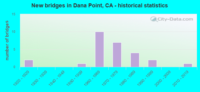
- New bridges - historical statistics
- 21920-1929
- 11950-1959
- 101960-1969
- 71970-1979
- 41980-1989
- 21990-1999
- 12010-2019

- Reconstructed bridges - Historical Statistics
- 11940-1949
- 01950-1959
- 01960-1969
- 01970-1979
- 01980-1989
- 11990-1999
- 12000-2009
- 12010-2019


- Bridge Condition - Deck
- 58.8%Good
- 35.3%Fair
- 5.9%Poor

- Bridge Condition - Superstructure
- 68.4%Good
- 31.6%Fair

- Bridge Condition - Substructure
- 73.7%Good
- 5.3%Satisfactory
- 21.1%Fair
Find on map >> Show street view
Structure Number: 55 0001, Location: 12-ORA-001-21.55-HNTB (Lat: 33.630753, Lng: -117.956544), Route carried "on" structure: State highway 1, Year Built: 1992, Status: Open, Structure Length: 17.16m (56.30ft), Average Daily Traffic: 32,000 (year 2012), Truck Traffic: 1%, Average Future Daily Traffic: 42,908 (year 2040), Design Load: HS 20, Features Intersected: SANTA ANA RIVER
Minimum Vertical Clearance: 30+ m (98+ ft), Kilometerpoint: 21.550, Lanes on structure: 6, Base Highway Network: Yes (, Subroute: 1), Owner: State Highway Agency, Approaching Roadway Width: 29.0m (95.1ft), Skew: 30 degrees, Material/Design: Prestressed concrete continuous, Design/Construction: Stringer/Multi-beam, Number Of Spans In Main Unit: 5, Length of Maximum Span: 36.6m (120.1ft), Curb or Sidewalk Widths: Left: 1.8m (5.9ft), Right: 3.4m (11.2ft), Curb-To-Curb Width: 29.0m (95.1ft), Out-to-Out Width: 36.0m (118.1ft)
Condition: Deck: Good, Superstructure: Good, Substructure: Fair, Channel: Very good, Operating Rating: 54.1 metric tons, Method Used To Determine Operating Rating: Assigned rating based on Load Factor Design (LFD) reported in metric tons, Inventory Rating: 32.4 metric tons, Method Used To Determine Inventory Rating: Assigned rating based on Load Factor Design (LFD) reported in metric tons, Structural Evaluation: Somewhat better than minimum adequacy, Deck Geometry: Superior to present desirable criteria, Waterway Adequacy: Equal to present desirable criteria, Approach Roadway Alignment: Equal to present desirable criteria, Designated Inspection Frequency: Every 24 months, Underwater Inspection Frequency: Every 60 months, Inspection Date: June 2021, Underwater Inspection Date: Febuary 2020, Deck Structure Type: Concrete Cast-file-Place
Find on map >> Show street view
Structure Number: 55 001, Location: 12-ORA-001-31.75-SLB (Lat: 33.731461, Lng: -118.084558), Route carried "on" structure: State highway 1, Year Built: 1967, Status: Open, Structure Length: 10.76m (35.30ft), Average Daily Traffic: 41,000 (year 2012), Average Future Daily Traffic: 53,686 (year 2040), Design Load: HS 20, Features Intersected: ANAHEIM BAY
Minimum Vertical Clearance: 30+ m (98+ ft), Kilometerpoint: 31.750, Lanes on structure: 4, Base Highway Network: Yes (, Subroute: 1), Owner: State Highway Agency, Approaching Roadway Width: 20.1m (65.9ft), Skew: 30 degrees, Material/Design: Concrete continuous, Design/Construction: Box Beam or Girders - Multiple, Number Of Spans In Main Unit: 3, Length of Maximum Span: 36.3m (119.1ft), Curb or Sidewalk Widths: Left: 1.5m (4.9ft), Right: 1.5m (4.9ft), Curb-To-Curb Width: 20.1m (65.9ft), Out-to-Out Width: 24.4m (80.1ft)
Condition: Deck: Fair, Superstructure: Fair, Substructure: Fair, Channel: Very good, Operating Rating: 54.1 metric tons, Method Used To Determine Operating Rating: Assigned rating based on Load Factor Design (LFD) reported in metric tons, Inventory Rating: 32.4 metric tons, Method Used To Determine Inventory Rating: Assigned rating based on Load Factor Design (LFD) reported in metric tons, Structural Evaluation: Somewhat better than minimum adequacy, Deck Geometry: Better than present minimum criteria, Waterway Adequacy: Equal to present desirable criteria, Approach Roadway Alignment: Equal to present desirable criteria, Designated Inspection Frequency: Every 24 months, Underwater Inspection Frequency: Every 60 months, Inspection Date: June 2021, Underwater Inspection Date: Febuary 2020, Deck Structure Type: Concrete Cast-file-Place
Find on map >> Show street view
Structure Number: 55 0015Y, Location: 12-ORA-001-R1.00-DAPT (Lat: 33.463686, Lng: -117.682214), Route carried "on" structure: Ramp State highway 1, Year Built: 1927, Year Reconstructed: 1947, Status: Open, Structure Length: 13.23m (43.41ft), Average Daily Traffic: 8,000 (year 2012), Truck Traffic: 6%, Average Future Daily Traffic: 9,499 (year 2040), Design Load: HS 20, Features Intersected: SAN JUAN CREEK
Minimum Vertical Clearance: 30+ m (98+ ft), Kilometerpoint: 1.000, Lanes on structure: 3, Owner: State Highway Agency, Approaching Roadway Width: 16.4m (53.8ft), Skew: 20 degrees, Material/Design: Concrete, Design/Construction: Tee Beam, Number Of Spans In Main Unit: 8, Length of Maximum Span: 16.5m (54.1ft), Curb or Sidewalk Widths: Left: 1.3m (4.3ft), Right: 1.3m (4.3ft), Curb-To-Curb Width: 16.4m (53.8ft), Out-to-Out Width: 19.7m (64.6ft)
Condition: Deck: Fair, Superstructure: Fair, Substructure: Fair, Channel: Very good, Operating Rating: 54.1 metric tons, Method Used To Determine Operating Rating: Assigned rating based on Load Factor Design (LFD) reported in metric tons, Inventory Rating: 32.4 metric tons, Method Used To Determine Inventory Rating: Assigned rating based on Load Factor Design (LFD) reported in metric tons, Structural Evaluation: Somewhat better than minimum adequacy, Deck Geometry: Superior to present desirable criteria, Waterway Adequacy: Equal to present desirable criteria, Approach Roadway Alignment: Better than present minimum criteria, Designated Inspection Frequency: Every 24 months, Inspection Date: June 2021, Deck Structure Type: Concrete Cast-file-Place, Wearing Surface/Protective System: Wearing Surface: Bituminous
Find on map >> Show street view
Structure Number: 55 0224, Location: 12-ORA-005-5.80-DAPT (Lat: 33.458536, Lng: -117.656067), Route carried "on" structure: City street , Year Built: 1981, Year Reconstructed: 2012, Status: Open, Structure Length: 6.74m (22.11ft), Average Daily Traffic: 10,000 (year 2009), Truck Traffic: 3%, Average Future Daily Traffic: 12,319 (year 2043), Design Load: HS 20+Mod, Features Intersected: INTERSTATE 5, Facility Carried by Structure: CAMINO DE ESTRELLA
Minimum Vertical Clearance: 30+ m (98+ ft), Kilometerpoint: 0.000, Lanes on structure: 7, Lanes under structure: 9, Owner: State Highway Agency, Approaching Roadway Width: 28.6m (93.8ft), Skew: 30 degrees, Material/Design: Prestressed concrete continuous, Design/Construction: Box Beam or Girders - Multiple, Number Of Spans In Main Unit: 2, Length of Maximum Span: 36.9m (121.1ft), Curb or Sidewalk Widths: Left: 2.1m (6.9ft), Right: 2.1m (6.9ft), Curb-To-Curb Width: 28.6m (93.8ft), Out-to-Out Width: 33.5m (109.9ft)
Condition: Deck: Fair, Superstructure: Good, Substructure: Good, Operating Rating: 54.1 metric tons, Method Used To Determine Operating Rating: Assigned rating based on Load Factor Design (LFD) reported in metric tons, Inventory Rating: 32.4 metric tons, Method Used To Determine Inventory Rating: Assigned rating based on Load Factor Design (LFD) reported in metric tons, Structural Evaluation: Better than present minimum criteria, Deck Geometry: Somewhat better than minimum adequacy, Underclear: Meets minimum limits, Approach Roadway Alignment: Equal to present desirable criteria, Designated Inspection Frequency: Every 24 months, Inspection Date: April 2021, Deck Structure Type: Concrete Cast-file-Place
Find on map >> Show street view
Structure Number: 55 0225, Location: 12-ORA-005-6.62-DAPT (Lat: 33.465364, Lng: -117.667800), Route carried "on" structure: County highway , Year Built: 1960, Status: Open, Structure Length: 13.44m (44.09ft), Average Daily Traffic: 5,000 (year 2009), Truck Traffic: 3%, Average Future Daily Traffic: 5,918 (year 2037), Design Load: HS 20, Features Intersected: ROUTE 5, Facility Carried by Structure: VIA CALIFORNIA
Minimum Vertical Clearance: 30+ m (98+ ft), Kilometerpoint: 0.000, Lanes on structure: 2, Lanes under structure: 14, Owner: State Highway Agency, Approaching Roadway Width: 12.2m (40.0ft), Material/Design: Concrete continuous, Design/Construction: Box Beam or Girders - Multiple, Number Of Spans In Main Unit: 6, Length of Maximum Span: 29.6m (97.1ft), Curb or Sidewalk Widths: Left: 1.5m (4.9ft), Right: 1.5m (4.9ft), Curb-To-Curb Width: 12.2m (40.0ft), Out-to-Out Width: 15.8m (51.8ft)
Condition: Deck: Good, Superstructure: Good, Substructure: Satisfactory, Operating Rating: 54.1 metric tons, Method Used To Determine Operating Rating: Assigned rating based on Load Factor Design (LFD) reported in metric tons, Inventory Rating: 32.4 metric tons, Method Used To Determine Inventory Rating: Assigned rating based on Load Factor Design (LFD) reported in metric tons, Structural Evaluation: Equal to present minimum criteria, Deck Geometry: Equal to present minimum criteria, Underclear: High priority of corrective action, Approach Roadway Alignment: Better than present minimum criteria, Designated Inspection Frequency: Every 48 months, Inspection Date: April 2019, Deck Structure Type: Concrete Cast-file-Place
Find on map >> Show street view
Structure Number: 55 0226, Location: 12-ORA-005-6.69 (Lat: 33.466342, Lng: -117.668092), Route carried "on" structure: Interstate 5, Year Built: 1960, Year Reconstructed: 2017, Status: Open, Structure Length: 6.98m (22.90ft), Average Daily Traffic: 234,300 (year 2015), Truck Traffic: 4%, Average Future Daily Traffic: 298,413 (year 2043), Design Load: HS 20, Features Intersected: N5-N1 CONNECTOR
Minimum Vertical Clearance: 30+ m (98+ ft), Kilometerpoint: 6.690, Lanes on structure: 11, Lanes under structure: 2, Base Highway Network: Yes (, Subroute: 1), Owner: State Highway Agency, Approaching Roadway Width: 54.9m (180.1ft), Skew: 39 degrees, Material/Design: Concrete continuous, Design/Construction: Box Beam or Girders - Multiple, Number Of Spans In Main Unit: 3, Length of Maximum Span: 32.0m (105.0ft), Curb-To-Curb Width: 54.9m (180.1ft), Out-to-Out Width: 56.5m (185.4ft)
Condition: Deck: Good, Superstructure: Good, Substructure: Good, Operating Rating: 54.1 metric tons, Method Used To Determine Operating Rating: Assigned rating based on Load Factor Design (LFD) reported in metric tons, Inventory Rating: 32.4 metric tons, Method Used To Determine Inventory Rating: Assigned rating based on Load Factor Design (LFD) reported in metric tons, Structural Evaluation: Better than present minimum criteria, Deck Geometry: Superior to present desirable criteria, Underclear: Somewhat better than minimum adequacy, Approach Roadway Alignment: Equal to present desirable criteria, Designated Inspection Frequency: Every 24 months, Inspection Date: April 2021, Deck Structure Type: Concrete Cast-file-Place, Wearing Surface/Protective System: Wearing Surface: Bituminous
Find on map >> Show street view
Structure Number: 55 023, Location: 12-ORA-005-10.00-SJCP (Lat: 33.508278, Lng: -117.660147), Route carried "on" structure: Interstate 5, Year Built: 1958, Year Reconstructed: 1997, Status: Open, Structure Length: 5.42m (17.78ft), Average Daily Traffic: 316,000 (year 2016), Truck Traffic: 4%, Average Future Daily Traffic: 343,915 (year 2043), Design Load: HS 20, Features Intersected: EL HORNO STREET
Minimum Vertical Clearance: 30+ m (98+ ft), Kilometerpoint: 10.000, Lanes on structure: 12, Lanes under structure: 2, Base Highway Network: Yes (, Subroute: 1), Owner: State Highway Agency, Approaching Roadway Width: 59.0m (193.6ft), Skew: 34 degrees, Material/Design: Concrete continuous, Design/Construction: Tee Beam, Number Of Spans In Main Unit: 3, Length of Maximum Span: 25.3m (83.0ft), Curb-To-Curb Width: 59.0m (193.6ft), Out-to-Out Width: 60.2m (197.5ft)
Condition: Deck: Good, Superstructure: Good, Substructure: Good, Operating Rating: 54.1 metric tons, Method Used To Determine Operating Rating: Assigned rating based on Load Factor Design (LFD) reported in metric tons, Inventory Rating: 32.4 metric tons, Method Used To Determine Inventory Rating: Assigned rating based on Load Factor Design (LFD) reported in metric tons, Structural Evaluation: Better than present minimum criteria, Deck Geometry: Superior to present desirable criteria, Underclear: Meets minimum limits, Approach Roadway Alignment: Equal to present desirable criteria, Designated Inspection Frequency: Every 24 months, Inspection Date: April 2021, Deck Structure Type: Concrete Cast-file-Place
Find on map >> Show street view
Structure Number: 55 0239, Location: 12-ORA-001-R0.40-DAPT (Lat: 33.464208, Lng: -117.672647), Route carried "on" structure: State highway 1, Year Built: 1960, Status: Open, Structure Length: 6.77m (22.21ft), Average Daily Traffic: 37,000 (year 2012), Truck Traffic: 6%, Average Future Daily Traffic: 47,900 (year 2040), Design Load: HS 20, Features Intersected: CAMINO CAPISTRANO
Minimum Vertical Clearance: 30+ m (98+ ft), Kilometerpoint: 0.400, Lanes on structure: 5, Lanes under structure: 3, Base Highway Network: Yes (, Subroute: 1), Owner: State Highway Agency, Approaching Roadway Width: 25.3m (83.0ft), Skew: 29 degrees, Material/Design: Concrete continuous, Design/Construction: Box Beam or Girders - Multiple, Number Of Spans In Main Unit: 3, Length of Maximum Span: 29.6m (97.1ft), Curb or Sidewalk Widths: Left: 0.6m (2.0ft), Right: 0.6m (2.0ft), Curb-To-Curb Width: 25.3m (83.0ft), Out-to-Out Width: 30.7m (100.7ft)
Condition: Deck: Fair, Superstructure: Good, Substructure: Fair, Operating Rating: 44.4 metric tons, Method Used To Determine Operating Rating: Load and Resistance Factor Rating (LRFR) rating reported by rating factor(RF) method using HL-93 loadings, Inventory Rating: 34.3 metric tons, Method Used To Determine Inventory Rating: Load and Resistance Factor Rating (LRFR) rating reported by rating factor(RF) method using HL-93 loadings, Structural Evaluation: Somewhat better than minimum adequacy, Deck Geometry: Better than present minimum criteria, Underclear: High priority of corrective action, Approach Roadway Alignment: Equal to present desirable criteria, Designated Inspection Frequency: Every 24 months, Inspection Date: June 2021, Deck Structure Type: Concrete Cast-file-Place
Find on map >> Show street view
Structure Number: 55 0511, Location: 12-ORA-001-R0.20-DAPT (Lat: 33.466042, Lng: -117.670658), Route carried "on" structure: State highway 1, Year Built: 1973, Status: Open, Structure Length: 9.36m (30.71ft), Average Daily Traffic: 37,000 (year 2012), Truck Traffic: 6%, Average Future Daily Traffic: 47,900 (year 2040), Design Load: HS 20, Features Intersected: N5-N1 CONNECTOR RAMP
Minimum Vertical Clearance: 30+ m (98+ ft), Kilometerpoint: 0.200, Lanes on structure: 4, Lanes under structure: 1, Base Highway Network: Yes (, Subroute: 1), Owner: State Highway Agency, Approaching Roadway Width: 29.8m (97.8ft), Skew: 29 degrees, Material/Design: Concrete, Design/Construction: Box Beam or Girders - Multiple, Number Of Spans In Main Unit: 1, Length of Maximum Span: 93.6m (307.1ft), Curb-To-Curb Width: 29.8m (97.8ft), Out-to-Out Width: 29.8m (97.8ft)
Condition: Deck: Good, Superstructure: Fair, Substructure: Good, Operating Rating: 54.1 metric tons, Method Used To Determine Operating Rating: Assigned rating based on Load Factor Design (LFD) reported in metric tons, Inventory Rating: 32.4 metric tons, Method Used To Determine Inventory Rating: Assigned rating based on Load Factor Design (LFD) reported in metric tons, Structural Evaluation: Somewhat better than minimum adequacy, Deck Geometry: Superior to present desirable criteria, Underclear: High priority of corrective action, Approach Roadway Alignment: Equal to present desirable criteria, Designated Inspection Frequency: Every 24 months, Inspection Date: June 2021, Deck Structure Type: Concrete Cast-file-Place
Find on map >> Show street view
Structure Number: 55 0545, Location: 12-ORA-001-R0.78-DAPT (Lat: 33.464278, Lng: -117.678842), Route carried "on" structure: State highway 1, Year Built: 1976, Status: Open, Structure Length: 5.00m (16.40ft), Average Daily Traffic: 37,000 (year 2012), Truck Traffic: 6%, Average Future Daily Traffic: 48,704 (year 2040), Design Load: HS 20, Features Intersected: DOHENY PARK RD
Minimum Vertical Clearance: 30+ m (98+ ft), Kilometerpoint: 0.780, Lanes on structure: 6, Lanes under structure: 4, Base Highway Network: Yes (, Subroute: 1), Owner: State Highway Agency, Approaching Roadway Width: 28.8m (94.5ft), Skew: 39 degrees, Material/Design: Prestressed concrete, Design/Construction: Box Beam or Girders - Multiple, Number Of Spans In Main Unit: 1, Length of Maximum Span: 49.4m (162.1ft), Curb-To-Curb Width: 28.8m (94.5ft), Out-to-Out Width: 30.1m (98.8ft)
Condition: Deck: Good, Superstructure: Good, Substructure: Good, Operating Rating: 54.1 metric tons, Method Used To Determine Operating Rating: Assigned rating based on Load Factor Design (LFD) reported in metric tons, Inventory Rating: 32.4 metric tons, Method Used To Determine Inventory Rating: Assigned rating based on Load Factor Design (LFD) reported in metric tons, Structural Evaluation: Better than present minimum criteria, Deck Geometry: Better than present minimum criteria, Underclear: High priority of corrective action, Approach Roadway Alignment: Equal to present desirable criteria, Designated Inspection Frequency: Every 24 months, Inspection Date: June 2021, Deck Structure Type: Concrete Cast-file-Place
Find on map >> Show street view
Structure Number: 55 0546, Location: 12-ORA-001-R0.86-DAPT (Lat: 33.464539, Lng: -117.680247), Route carried "on" structure: State highway 1, Year Built: 1976, Status: Open, Structure Length: 5.46m (17.91ft), Average Daily Traffic: 37,000 (year 2012), Truck Traffic: 6%, Average Future Daily Traffic: 48,704 (year 2040), Design Load: HS 20+Mod, Features Intersected: BNSF RY,AMTRAK,METROLINK
Minimum Vertical Clearance: 30+ m (98+ ft), Kilometerpoint: 0.860, Lanes on structure: 4, Base Highway Network: Yes (, Subroute: 1), Owner: State Highway Agency, Approaching Roadway Width: 21.3m (69.9ft), Skew: 30 degrees, Material/Design: Prestressed concrete continuous, Design/Construction: Box Beam or Girders - Multiple, Number Of Spans In Main Unit: 2, Length of Maximum Span: 28.3m (92.8ft), Curb-To-Curb Width: 21.3m (69.9ft), Out-to-Out Width: 22.6m (74.1ft)
Condition: Deck: Good, Superstructure: Good, Substructure: Good, Operating Rating: 54.1 metric tons, Method Used To Determine Operating Rating: Assigned rating based on Load Factor Design (LFD) reported in metric tons, Inventory Rating: 32.4 metric tons, Method Used To Determine Inventory Rating: Assigned rating based on Load Factor Design (LFD) reported in metric tons, Structural Evaluation: Better than present minimum criteria, Deck Geometry: Better than present minimum criteria, Underclear: Superior to present desirable criteria, Approach Roadway Alignment: Equal to present desirable criteria, Designated Inspection Frequency: Every 48 months, Inspection Date: June 2021, Deck Structure Type: Concrete Cast-file-Place
Find on map >> Show street view
Structure Number: 55 0546S, Location: 12-ORA-001-R0.85-DAPT (Lat: 33.464664, Lng: -117.680256), Route carried "on" structure: Ramp State highway 1, Year Built: 1976, Status: Open, Structure Length: 5.39m (17.68ft), Average Daily Traffic: 3,000 (year 2012), Truck Traffic: 1%, Average Future Daily Traffic: 3,563 (year 2040), Design Load: HS 20+Mod, Features Intersected: BNSF RY,AMTRAK,METROLINK
Minimum Vertical Clearance: 30+ m (98+ ft), Kilometerpoint: 0.850, Lanes on structure: 1, Owner: State Highway Agency, Approaching Roadway Width: 7.3m (24.0ft), Material/Design: Prestressed concrete continuous, Design/Construction: Box Beam or Girders - Multiple, Number Of Spans In Main Unit: 2, Length of Maximum Span: 28.3m (92.8ft), Curb-To-Curb Width: 7.3m (24.0ft), Out-to-Out Width: 7.9m (25.9ft)
Condition: Deck: Good, Superstructure: Good, Substructure: Good, Operating Rating: 54.1 metric tons, Method Used To Determine Operating Rating: Assigned rating based on Load Factor Design (LFD) reported in metric tons, Inventory Rating: 32.4 metric tons, Method Used To Determine Inventory Rating: Assigned rating based on Load Factor Design (LFD) reported in metric tons, Structural Evaluation: Better than present minimum criteria, Deck Geometry: Better than present minimum criteria, Underclear: Better than present minimum criteria, Approach Roadway Alignment: Equal to present desirable criteria, Designated Inspection Frequency: Every 48 months, Inspection Date: June 2021, Deck Structure Type: Concrete Cast-file-Place
Find on map >> Show street view
Structure Number: 55 0547, Location: 12-ORA-001-R0.97-DAPT (Lat: 33.464489, Lng: -117.681956), Route carried "on" structure: State highway 1, Year Built: 1976, Status: Open, Structure Length: 15.48m (50.79ft), Average Daily Traffic: 37,000 (year 2012), Truck Traffic: 6%, Average Future Daily Traffic: 48,704 (year 2040), Design Load: HS 20, Features Intersected: SAN JUAN CREEK
Minimum Vertical Clearance: 30+ m (98+ ft), Kilometerpoint: 0.970, Lanes on structure: 4, Base Highway Network: Yes (, Subroute: 1), Owner: State Highway Agency, Approaching Roadway Width: 20.7m (67.9ft), Skew: 29 degrees, Material/Design: Prestressed concrete continuous, Design/Construction: Box Beam or Girders - Multiple, Number Of Spans In Main Unit: 5, Length of Maximum Span: 40.8m (133.9ft), Curb-To-Curb Width: 20.7m (67.9ft), Out-to-Out Width: 22.6m (74.1ft)
Condition: Deck: Good, Superstructure: Good, Substructure: Good, Channel: Very good, Operating Rating: 54.1 metric tons, Method Used To Determine Operating Rating: Assigned rating based on Load Factor Design (LFD) reported in metric tons, Inventory Rating: 32.4 metric tons, Method Used To Determine Inventory Rating: Assigned rating based on Load Factor Design (LFD) reported in metric tons, Structural Evaluation: Better than present minimum criteria, Deck Geometry: Equal to present minimum criteria, Waterway Adequacy: Equal to present desirable criteria, Approach Roadway Alignment: Equal to present desirable criteria, Designated Inspection Frequency: Every 24 months, Inspection Date: June 2021, Deck Structure Type: Concrete Cast-file-Place
Find on map >> Show street view
Structure Number: 55C0521, Location: 0.1 MI W/O ROUTE 1 (Lat: 33.476778, Lng: -117.719194), Route carried "on" structure: City street , Year Built: 1974, Status: Open, Structure Length: 0.79m (2.59ft), Average Daily Traffic: 5,300 (year 2019), Truck Traffic: 1%, Average Future Daily Traffic: 6,306 (year 2038), Design Load: HS 20, Features Intersected: SALT CREEK BEACH PARK, Facility Carried by Structure: RITZ CARLTON DRIVE
Minimum Vertical Clearance: 30+ m (98+ ft), Kilometerpoint: 0.000, Lanes on structure: 2, Owner: City or Municipal Highway Agency, Approaching Roadway Width: 14.6m (47.9ft), Material/Design: Concrete, Design/Construction: Slab, Number Of Spans In Main Unit: 1, Length of Maximum Span: 7.3m (24.0ft), Curb or Sidewalk Widths: Left: 1.6m (5.2ft), Right: 0.4m (1.3ft), Curb-To-Curb Width: 14.6m (47.9ft), Out-to-Out Width: 17.1m (56.1ft)
Condition: Deck: Fair, Superstructure: Fair, Substructure: Good, Operating Rating: 83.6 metric tons, Method Used To Determine Operating Rating: Load Factor (LF), Inventory Rating: 50.2 metric tons, Method Used To Determine Inventory Rating: Load Factor (LF), Structural Evaluation: Somewhat better than minimum adequacy, Deck Geometry: Superior to present desirable criteria, Approach Roadway Alignment: Equal to present desirable criteria, Designated Inspection Frequency: Every 24 months, Inspection Date: August 2020, Deck Structure Type: Concrete Cast-file-Place
Find on map >> Show street view
Structure Number: 55C0607, Location: 0.4 MI. E/O DEL OBISPO ST (Lat: 33.474394, Lng: -117.679767), Route carried "on" structure: City street , Year Built: 1992, Status: Open, Structure Length: 7.96m (26.12ft), Average Daily Traffic: 31,000 (year 2019), Truck Traffic: 1%, Average Future Daily Traffic: 27,241 (year 2038), Design Load: HS 20+Mod, Features Intersected: SAN JUAN CREEK CHANNEL, Facility Carried by Structure: STONEHILL DRIVE
Minimum Vertical Clearance: 30+ m (98+ ft), Kilometerpoint: 0.000, Lanes on structure: 4, Owner: City or Municipal Highway Agency, Approaching Roadway Width: 25.6m (84.0ft), Material/Design: Prestressed concrete continuous, Design/Construction: Box Beam or Girders - Multiple, Number Of Spans In Main Unit: 2, Length of Maximum Span: 37.8m (124.0ft), Curb or Sidewalk Widths: Left: 1.5m (4.9ft), Right: 1.5m (4.9ft), Curb-To-Curb Width: 25.6m (84.0ft), Out-to-Out Width: 29.3m (96.1ft)
Condition: Deck: Poor, Superstructure: Good, Substructure: Good, Channel: Very good, Operating Rating: 54.1 metric tons, Method Used To Determine Operating Rating: Assigned rating based on Load Factor Design (LFD) reported in metric tons, Inventory Rating: 32.4 metric tons, Method Used To Determine Inventory Rating: Assigned rating based on Load Factor Design (LFD) reported in metric tons, Structural Evaluation: Better than present minimum criteria, Deck Geometry: Superior to present desirable criteria, Waterway Adequacy: Equal to present desirable criteria, Approach Roadway Alignment: Equal to present desirable criteria, Designated Inspection Frequency: Every 24 months, Inspection Date: August 2020, Deck Structure Type: Concrete Cast-file-Place
Find on map >> Show street view
Structure Number: 55C069, Location: 0.25 SOUTH SANTIAGO RD (Lat: 33.810294, Lng: -117.782244), Route carried "on" structure: City street , Year Built: 2012, Status: Open, Structure Length: 1.20m (3.94ft), Average Daily Traffic: 1,100 (year 2019), Truck Traffic: 2%, Average Future Daily Traffic: 2,033 (year 2037), Design Load: HL 93, Features Intersected: HANDY CREEK, Facility Carried by Structure: ORANGE PARK BLVD
Minimum Vertical Clearance: 30+ m (98+ ft), Kilometerpoint: 0.000, Lanes on structure: 2, Owner: City or Municipal Highway Agency, Approaching Roadway Width: 13.2m (43.3ft), Skew: 2 degrees, Material/Design: Concrete, Design/Construction: Slab, Number Of Spans In Main Unit: 1, Length of Maximum Span: 11.7m (38.4ft), Curb-To-Curb Width: 13.2m (43.3ft), Out-to-Out Width: 17.8m (58.4ft)
Condition: Deck: Good, Superstructure: Good, Substructure: Good, Channel: Very good, Operating Rating: 42.1 metric tons, Method Used To Determine Operating Rating: Assigned ratings based on Load and Resistance Factor Design (LRFD) reported by rating factor (RF) using HL93 loadings, Inventory Rating: 32.4 metric tons, Method Used To Determine Inventory Rating: Assigned ratings based on Load and Resistance Factor Design (LRFD) reported by rating factor (RF) using HL93 loadings, Structural Evaluation: Better than present minimum criteria, Deck Geometry: Better than present minimum criteria, Waterway Adequacy: Superior to present desirable criteria, Approach Roadway Alignment: Equal to present desirable criteria, Designated Inspection Frequency: Every 48 months, Inspection Date: July 2019, Deck Structure Type: Concrete Cast-file-Place
Find on map >> Show street view
Structure Number: 55C0697, Location: .17 MI SE OF NIGUEL DR (Lat: 33.473847, Lng: -117.715036), Route carried "on" structure: City street , Year Built: 1969, Status: Open, Structure Length: 4.48m (14.70ft), Average Daily Traffic: 5,000 (year 2019), Truck Traffic: 1%, Average Future Daily Traffic: 5,918 (year 2038), Design Load: HS 20, Features Intersected: SR 1 PACIFIC COAST HWY, Facility Carried by Structure: NIGUEL SHORES DR
Minimum Vertical Clearance: 30+ m (98+ ft), Kilometerpoint: 0.000, Lanes on structure: 2, Lanes under structure: 4, Owner: City or Municipal Highway Agency, Approaching Roadway Width: 7.3m (24.0ft), Material/Design: Concrete continuous, Design/Construction: Box Beam or Girders - Multiple, Number Of Spans In Main Unit: 2, Length of Maximum Span: 21.9m (71.9ft), Curb or Sidewalk Widths: Left: 2.4m (7.9ft), Right: 1.2m (3.9ft), Curb-To-Curb Width: 7.3m (24.0ft), Out-to-Out Width: 11.6m (38.1ft)
Condition: Deck: Fair, Superstructure: Good, Substructure: Good, Operating Rating: 37.6 metric tons, Method Used To Determine Operating Rating: Load and Resistance Factor Rating (LRFR) rating reported by rating factor(RF) method using HL-93 loadings, Inventory Rating: 28.8 metric tons, Method Used To Determine Inventory Rating: Load and Resistance Factor Rating (LRFR) rating reported by rating factor(RF) method using HL-93 loadings, Structural Evaluation: Better than present minimum criteria, Deck Geometry: High priority of replacement, Underclear: Meets minimum limits, Approach Roadway Alignment: Equal to present desirable criteria, Designated Inspection Frequency: Every 24 months, Inspection Date: August 2020, Deck Structure Type: Concrete Cast-file-Place, Wearing Surface/Protective System: Wearing Surface: Monolithic Concrete
Find on map >> Show street view
Structure Number: 55C0698, Location: .12 MI NW NIGUEL RD (Lat: 33.477475, Lng: -117.717608), Route carried "on" structure: City street , Year Built: 1969, Status: Open, Structure Length: 0.73m (2.40ft), Average Daily Traffic: 40,000 (year 2019), Truck Traffic: 5%, Average Future Daily Traffic: 45,037 (year 2038), Design Load: H 15, Features Intersected: PEDESTRIAN WALKWAY, Facility Carried by Structure: PACIFIC COAST HWY
Minimum Vertical Clearance: 30+ m (98+ ft), Kilometerpoint: 0.000, Lanes on structure: 4, Base Highway Network: Yes (, Subroute: 1), Owner: City or Municipal Highway Agency, Approaching Roadway Width: 23.8m (78.1ft), Material/Design: Steel, Design/Construction: Arch - Deck, Number Of Spans In Main Unit: 1, Length of Maximum Span: 7.3m (24.0ft), Curb-To-Curb Width: 23.8m (78.1ft), Out-to-Out Width: 43.0m (141.1ft)
Condition: Superstructure: Fair, Substructure: Good, Operating Rating: 40.5 metric tons, Method Used To Determine Operating Rating: Field evaluation and documented engineering judgment, Inventory Rating: 24.3 metric tons, Method Used To Determine Inventory Rating: Field evaluation and documented engineering judgment, Structural Evaluation: Somewhat better than minimum adequacy, Deck Geometry: Superior to present desirable criteria, Approach Roadway Alignment: Equal to present desirable criteria, Designated Inspection Frequency: Every 24 months, Inspection Date: August 2020
Find on map >> Show street view
Structure Number: 55C0699, Location: 0.09 MI SE OF PT MONARCH (Lat: 33.482447, Lng: -117.721853), Route carried "on" structure: City street , Year Built: 1983, Status: Open, Structure Length: 1.01m (3.31ft), Average Daily Traffic: 40,000 (year 2019), Truck Traffic: 3%, Average Future Daily Traffic: 45,037 (year 2038), Features Intersected: PEDESTRIAN WALKWAY, Facility Carried by Structure: PACIFIC COAST HWY
Minimum Vertical Clearance: 30+ m (98+ ft), Kilometerpoint: 0.000, Lanes on structure: 4, Base Highway Network: Yes (, Subroute: 1), Owner: City or Municipal Highway Agency, Approaching Roadway Width: 24.7m (81.0ft), Skew: 21 degrees, Material/Design: Steel, Design/Construction: Arch - Deck, Number Of Spans In Main Unit: 1, Length of Maximum Span: 9.4m (30.8ft), Curb-To-Curb Width: 24.7m (81.0ft), Out-to-Out Width: 24.7m (81.0ft)
Condition: Superstructure: Fair, Substructure: Good, Operating Rating: 54.1 metric tons, Method Used To Determine Operating Rating: Field evaluation and documented engineering judgment, Inventory Rating: 32.4 metric tons, Method Used To Determine Inventory Rating: Field evaluation and documented engineering judgment, Structural Evaluation: Somewhat better than minimum adequacy, Deck Geometry: Superior to present desirable criteria, Approach Roadway Alignment: Equal to present desirable criteria, Designated Inspection Frequency: Every 24 months, Inspection Date: August 2020
Find on map >> Show street view
Structure Number: 55 0007, Location: 12-ORA-001-R0.80-DAPT (Lat: 33.463111, Lng: -117.680056), Route carried "under" structure: Ramp State highway 1, Year Built: 1927, Structure Length: 0. m, Average Daily Traffic: 8,000 (year 2009), Truck Traffic: 6%, Features Intersected: S1-COAST HIGHWAY OFFRAMP, Facility Carried by Structure: BNSF,AMTRAK,METRO
Minimum Vertical Clearance: 4.47m (14.67ft), Kilometerpoint: 0.800, Lanes under structure: 2, Material/Design: Steel, Design/Construction: Girder and Floorbeam System, Length of Maximum Span: 24.1m (79.1ft)
Find on map >> Show street view
Structure Number: 55 0224, Location: 12-ORA-005-5.80-DAPT (Lat: 33.458536, Lng: -117.656067), Route carried "under" structure: Interstate 5, Year Built: 1981, Structure Length: 0. m, Average Daily Traffic: 205,600 (year 2019), Truck Traffic: 8%, Features Intersected: INTERSTATE 5, Facility Carried by Structure: CAMINO DE ESTRELLA
Minimum Vertical Clearance: 5.02m (16.47ft), Kilometerpoint: 5.800, Lanes on structure: 7, Lanes under structure: 9, Material/Design: Prestressed concrete continuous, Design/Construction: Box Beam or Girders - Multiple, Length of Maximum Span: 36.9m (121.1ft)
Find on map >> Show street view
Structure Number: 55 0225, Location: 12-ORA-005-6.62-DAPT (Lat: 33.465364, Lng: -117.667800), Route carried "under" structure: Interstate 5, Year Built: 1960, Structure Length: 0. m, Average Daily Traffic: 267,000 (year 2016), Truck Traffic: 10%, Features Intersected: ROUTE 5, Facility Carried by Structure: VIA CALIFORNIA
Minimum Vertical Clearance: 9.14m (29.99ft), Kilometerpoint: 6.620, Lanes on structure: 2, Lanes under structure: 14, Material/Design: Concrete continuous, Design/Construction: Box Beam or Girders - Multiple, Length of Maximum Span: 29.6m (97.1ft)
Find on map >> Show street view
Structure Number: 55 0226, Location: 12-ORA-005-6.69 (Lat: 33.466342, Lng: -117.668092), Route carried "under" structure: Ramp Interstate 5, Year Built: 1960, Structure Length: 0. m, Average Daily Traffic: 14,900 (year 2009), Truck Traffic: 4%, Features Intersected: N5-N1 CONNECTOR
Minimum Vertical Clearance: 4.92m (16.14ft), Kilometerpoint: 6.690, Lanes on structure: 11, Lanes under structure: 2, Material/Design: Concrete continuous, Design/Construction: Box Beam or Girders - Multiple, Length of Maximum Span: 32.0m (105.0ft)
Find on map >> Show street view
Structure Number: 55 0239, Location: 12-ORA-001-R0.40-DAPT (Lat: 33.464208, Lng: -117.672647), Route carried "under" structure: City street , Year Built: 1960, Structure Length: 0. m, Average Daily Traffic: 1,000 (year 2012), Truck Traffic: 1%, Features Intersected: CAMINO CAPISTRANO, Facility Carried by Structure: STATE ROUTE 1
Minimum Vertical Clearance: 7.44m (24.41ft), Kilometerpoint: 0.000, Lanes on structure: 5, Lanes under structure: 3, Material/Design: Concrete continuous, Design/Construction: Box Beam or Girders - Multiple, Length of Maximum Span: 29.6m (97.1ft)
Find on map >> Show street view
Structure Number: 55 0511, Location: 12-ORA-001-R0.20-DAPT (Lat: 33.466042, Lng: -117.670658), Route carried "under" structure: Ramp Interstate 5, Year Built: 1973, Structure Length: 0. m, Average Daily Traffic: 14,900 (year 2012), Truck Traffic: 6%, Features Intersected: N5-N1 CONNECTOR RAMP, Facility Carried by Structure: STATE ROUTE 1
Minimum Vertical Clearance: 4.52m (14.83ft), Kilometerpoint: 6.690, Lanes on structure: 4, Lanes under structure: 1, Material/Design: Concrete, Design/Construction: Box Beam or Girders - Multiple, Length of Maximum Span: 93.6m (307.1ft)
Find on map >> Show street view
Structure Number: 55C0555, Location: 0.5 M S/O PARK LANTEM (Lat: 33.458289, Lng: -117.672969), Route carried "under" structure: City street , Year Built: 1986, Structure Length: 0. m, Average Daily Traffic: 19,000 (year 2017), Truck Traffic: 1%, Features Intersected: PACIFIC COAST HIGHWAY, Facility Carried by Structure: PEDESTRIAN WALKWAY
Minimum Vertical Clearance: 5.99m (19.65ft), Kilometerpoint: 0.000, Lanes under structure: 4, Material/Design: Prestressed concrete continuous, Design/Construction: Stringer/Multi-beam, Length of Maximum Span: 27.7m (90.9ft)
Find on map >> Show street view
Structure Number: 55C0697, Location: .17 MI SE OF NIGUEL DR (Lat: 33.473847, Lng: -117.715036), Route carried "under" structure: City street , Year Built: 1969, Structure Length: 0. m, Average Daily Traffic: 40,000 (year 2019), Truck Traffic: 5%, Features Intersected: SR 1 PACIFIC COAST HWY, Facility Carried by Structure: NIGUEL SHORES DR
Minimum Vertical Clearance: 5.02m (16.47ft), Kilometerpoint: 0.000, Lanes on structure: 2, Lanes under structure: 4, Material/Design: Concrete continuous, Design/Construction: Box Beam or Girders - Multiple, Length of Maximum Span: 21.9m (71.9ft)