Bridge Statistics for Danville, California (CA)
Condition, Traffic, Stress, Structural Evaluation, Project Costs
- National Bridge Inventory (NBI) Statistics
- 33Number of bridges
- 374ft / 114mTotal length
- $7,097,000Total costs
- 2,235,588Total average daily traffic
- 119,845Total average daily truck traffic
- National Bridge Inventory (NBI) Registered Bridges for Danville
- No street view available for this location
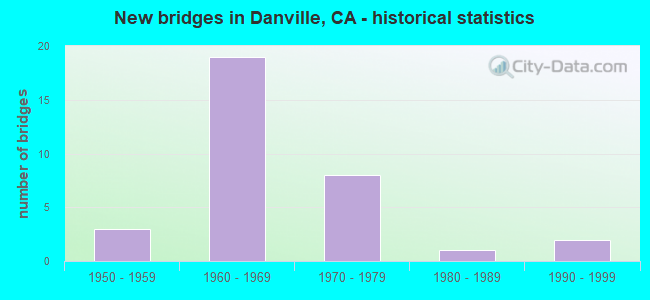
- New bridges - historical statistics
- 31950-1959
- 191960-1969
- 81970-1979
- 11980-1989
- 21990-1999

- Reconstructed bridges - Historical Statistics
- 71980-1989
- 21990-1999
- 12000-2009


- Bridge Condition - Deck
- 30.0%Good
- 10.0%Satisfactory
- 40.0%Fair
- 20.0%Poor

- Bridge Condition - Superstructure
- 80.0%Good
- 5.0%Satisfactory
- 15.0%Fair

- Bridge Condition - Channel
- 40.0%Very good
- 45.0%Good
- 15.0%Satisfactory

- Bridge Condition - Culverts
- 62.5%Good
- 37.5%Satisfactory
Find on map >> Show street view
Structure Number: 28 0057, Location: 04-CC-680-R4.46-DNVL (Lat: 37.781214, Lng: -121.976989), Route carried "on" structure: Interstate 680, Year Built: 1966, Status: Open, Structure Length: 0.79m (2.59ft), Average Daily Traffic: 176,400 (year 2017), Truck Traffic: 6%, Average Future Daily Traffic: 230,000 (year 2038), Features Intersected: SAN RAMON CREEK
Minimum Vertical Clearance: 30+ m (98+ ft), Kilometerpoint: 4.460, Lanes on structure: 10, Base Highway Network: Yes (Inventory Route: 6, Subroute: 1), Owner: State Highway Agency, Approaching Roadway Width: 42.1m (138.1ft), Skew: 4 degrees, Material/Design: Concrete continuous, Design/Construction: Culvert, Number Of Spans In Main Unit: 2, Length of Maximum Span: 3.7m (12.1ft)
Condition: Channel: Very good, Culverts: Satisfactory, Operating Rating: 54.1 metric tons, Method Used To Determine Operating Rating: Field evaluation and documented engineering judgment, Inventory Rating: 32.4 metric tons, Method Used To Determine Inventory Rating: Field evaluation and documented engineering judgment, Structural Evaluation: Equal to present minimum criteria, Waterway Adequacy: Equal to present desirable criteria, Approach Roadway Alignment: Equal to present desirable criteria, Designated Inspection Frequency: Every 48 months, Inspection Date: July 2018
Find on map >> Show street view
Structure Number: 28 019, Location: 04-CC-680-19.86-CND (Lat: 37.976100, Lng: -122.063775), Route carried "on" structure: Interstate 680, Year Built: 1962, Year Reconstructed: 1995, Status: Open, Structure Length: 4.69m (15.39ft), Average Daily Traffic: 130,000 (year 2009), Truck Traffic: 3%, Average Future Daily Traffic: 231,854 (year 2041), Design Load: HS 20+Mod, Features Intersected: CONCORD AVE
Minimum Vertical Clearance: 30+ m (98+ ft), Kilometerpoint: 19.860, Lanes on structure: 10, Lanes under structure: 7, Base Highway Network: Yes (Inventory Route: 6, Subroute: 1), Owner: State Highway Agency, Approaching Roadway Width: 41.9m (137.5ft), Skew: 31 degrees, Material/Design: Concrete continuous, Design/Construction: Box Beam or Girders - Multiple, Number Of Spans In Main Unit: 3, Length of Maximum Span: 26.9m (88.3ft), Curb-To-Curb Width: 41.9m (137.5ft), Out-to-Out Width: 43.5m (142.7ft)
Condition: Deck: Fair, Superstructure: Good, Substructure: Good, Operating Rating: 35.3 metric tons, Method Used To Determine Operating Rating: Load and Resistance Factor Rating (LRFR) rating reported by rating factor(RF) method using HL-93 loadings, Inventory Rating: 24.3 metric tons, Method Used To Determine Inventory Rating: Load and Resistance Factor Rating (LRFR) rating reported by rating factor(RF) method using HL-93 loadings, Structural Evaluation: Equal to present minimum criteria, Deck Geometry: Equal to present minimum criteria, Underclear: High priority of corrective action, Approach Roadway Alignment: Equal to present desirable criteria, Designated Inspection Frequency: Every 24 months, Inspection Date: January 2021, Deck Structure Type: Concrete Cast-file-Place
Find on map >> Show street view
Structure Number: 28 0192, Location: 04-CC-680-R9.25-DNVL (Lat: 37.839306, Lng: -122.016022), Route carried "on" structure: Interstate 680, Year Built: 1964, Year Reconstructed: 1994, Status: Open, Structure Length: 4.33m (14.21ft), Average Daily Traffic: 194,300 (year 2017), Truck Traffic: 6%, Average Future Daily Traffic: 252,600 (year 2038), Design Load: HS 20+Mod, Features Intersected: LA GONDA WAY
Minimum Vertical Clearance: 30+ m (98+ ft), Kilometerpoint: 9.250, Lanes on structure: 8, Lanes under structure: 2, Base Highway Network: Yes (Inventory Route: 6, Subroute: 1), Owner: State Highway Agency, Approaching Roadway Width: 42.1m (138.1ft), Skew: 31 degrees, Material/Design: Concrete continuous, Design/Construction: Box Beam or Girders - Multiple, Number Of Spans In Main Unit: 3, Length of Maximum Span: 20.1m (65.9ft), Curb-To-Curb Width: 41.3m (135.5ft), Out-to-Out Width: 42.7m (140.1ft)
Condition: Deck: Good, Superstructure: Good, Substructure: Good, Operating Rating: 33.4 metric tons, Method Used To Determine Operating Rating: Load and Resistance Factor Rating (LRFR) rating reported by rating factor(RF) method using HL-93 loadings, Inventory Rating: 25.9 metric tons, Method Used To Determine Inventory Rating: Load and Resistance Factor Rating (LRFR) rating reported by rating factor(RF) method using HL-93 loadings, Structural Evaluation: Equal to present minimum criteria, Deck Geometry: Superior to present desirable criteria, Underclear: Equal to present minimum criteria, Approach Roadway Alignment: Equal to present desirable criteria, Designated Inspection Frequency: Every 24 months, Inspection Date: July 2020, Deck Structure Type: Concrete Cast-file-Place, Wearing Surface/Protective System: Wearing Surface: Integral Concrete
Find on map >> Show street view
Structure Number: 28 0195, Location: 04-CC-680-R6.76-DNVL (Lat: 37.811244, Lng: -121.993297), Route carried "on" structure: City street , Year Built: 1964, Year Reconstructed: 1989, Status: Open, Structure Length: 8.60m (28.22ft), Average Daily Traffic: 3,000 (year 2009), Truck Traffic: 1%, Average Future Daily Traffic: 6,824 (year 2038), Design Load: HS 20+Mod, Features Intersected: INTERSTATE 680, Facility Carried by Structure: SYCAMORE VALLEY RD
Minimum Vertical Clearance: 30+ m (98+ ft), Kilometerpoint: 0.000, Lanes on structure: 7, Lanes under structure: 9, Owner: State Highway Agency, Approaching Roadway Width: 31.7m (104.0ft), Skew: 21 degrees, Material/Design: Concrete continuous, Design/Construction: Box Beam or Girders - Multiple, Number Of Spans In Main Unit: 4, Length of Maximum Span: 22.9m (75.1ft), Curb or Sidewalk Widths: Left: 2.4m (7.9ft), Right: 0.0m, Curb-To-Curb Width: 28.6m (93.8ft), Out-to-Out Width: 33.0m (108.3ft)
Condition: Deck: Good, Superstructure: Good, Substructure: Good, Operating Rating: 54.1 metric tons, Method Used To Determine Operating Rating: Assigned rating based on Load Factor Design (LFD) reported in metric tons, Inventory Rating: 32.4 metric tons, Method Used To Determine Inventory Rating: Assigned rating based on Load Factor Design (LFD) reported in metric tons, Structural Evaluation: Better than present minimum criteria, Deck Geometry: Somewhat better than minimum adequacy, Underclear: Meets minimum limits, Approach Roadway Alignment: Equal to present desirable criteria, Designated Inspection Frequency: Every 48 months, Inspection Date: July 2020, Deck Structure Type: Concrete Cast-file-Place, Wearing Surface/Protective System: Wearing Surface: Bituminous
Find on map >> Show street view
Structure Number: 28 0196, Location: 04-CC-680-R7.02-DNVL (Lat: 37.814725, Lng: -121.993072), Route carried "on" structure: Interstate 680, Year Built: 1964, Year Reconstructed: 2007, Status: Open, Structure Length: 12.47m (40.91ft), Average Daily Traffic: 192,200 (year 2017), Truck Traffic: 6%, Average Future Daily Traffic: 250,000 (year 2038), Design Load: HS 20+Mod, Features Intersected: LAUREL DRIVE
Minimum Vertical Clearance: 30+ m (98+ ft), Kilometerpoint: 7.020, Lanes on structure: 10, Lanes under structure: 2, Base Highway Network: Yes (Inventory Route: 6, Subroute: 1), Owner: State Highway Agency, Approaching Roadway Width: 48.6m (159.4ft), Skew: 35 degrees, Material/Design: Concrete continuous, Design/Construction: Box Beam or Girders - Multiple, Number Of Spans In Main Unit: 5, Length of Maximum Span: 30.5m (100.1ft), Curb-To-Curb Width: 48.6m (159.4ft), Out-to-Out Width: 50.1m (164.4ft)
Condition: Deck: Fair, Superstructure: Good, Substructure: Good, Operating Rating: 54.1 metric tons, Method Used To Determine Operating Rating: Assigned rating based on Load Factor Design (LFD) reported in metric tons, Inventory Rating: 32.4 metric tons, Method Used To Determine Inventory Rating: Assigned rating based on Load Factor Design (LFD) reported in metric tons, Structural Evaluation: Better than present minimum criteria, Deck Geometry: Superior to present desirable criteria, Underclear: Meets minimum limits, Approach Roadway Alignment: Equal to present desirable criteria, Length Of Structure Improvement: 12.47m (40.91ft), Designated Inspection Frequency: Every 24 months, Inspection Date: July 2020, Deck Structure Type: Concrete Cast-file-Place
Find on map >> Show street view
Structure Number: 28 0197, Location: 04-CC-680-R7.43-DNVL (Lat: 37.820906, Lng: -121.992989), Route carried "on" structure: Interstate 680, Year Built: 1964, Year Reconstructed: 1994, Status: Open, Structure Length: 6.36m (20.87ft), Average Daily Traffic: 192,200 (year 2017), Truck Traffic: 6%, Average Future Daily Traffic: 250,000 (year 2038), Design Load: HS 20+Mod, Features Intersected: SAN RAMON CREEK
Minimum Vertical Clearance: 30+ m (98+ ft), Kilometerpoint: 7.430, Lanes on structure: 8, Base Highway Network: Yes (Inventory Route: 6, Subroute: 1), Owner: State Highway Agency, Approaching Roadway Width: 42.7m (140.1ft), Skew: 30 degrees, Material/Design: Concrete continuous, Design/Construction: Tee Beam, Number Of Spans In Main Unit: 3, Length of Maximum Span: 24.7m (81.0ft), Curb-To-Curb Width: 40.8m (133.9ft), Out-to-Out Width: 42.1m (138.1ft)
Condition: Deck: Good, Superstructure: Good, Substructure: Good, Channel: Very good, Operating Rating: 31.1 metric tons, Method Used To Determine Operating Rating: Load and Resistance Factor Rating (LRFR) rating reported by rating factor(RF) method using HL-93 loadings, Inventory Rating: 24.0 metric tons, Method Used To Determine Inventory Rating: Load and Resistance Factor Rating (LRFR) rating reported by rating factor(RF) method using HL-93 loadings, Structural Evaluation: Somewhat better than minimum adequacy, Deck Geometry: Superior to present desirable criteria, Waterway Adequacy: Superior to present desirable criteria, Approach Roadway Alignment: Equal to present desirable criteria, Designated Inspection Frequency: Every 24 months, Inspection Date: July 2020, Deck Structure Type: Concrete Cast-file-Place, Wearing Surface/Protective System: Wearing Surface: Integral Concrete
Find on map >> Show street view
Structure Number: 28 0197K, Location: 04-CC-680-R7.43 (Lat: 37.820975, Lng: -121.993497), Route carried "on" structure: Ramp Interstate 680, Year Built: 1975, Status: Open, Structure Length: 6.22m (20.41ft), Average Daily Traffic: 4,750 (year 2009), Truck Traffic: 6%, Average Future Daily Traffic: 7,432 (year 2037), Design Load: HS 20+Mod, Features Intersected: SAN RAMON CREEK
Minimum Vertical Clearance: 30+ m (98+ ft), Kilometerpoint: 7.430, Lanes on structure: 1, Base Highway Network: Yes (Inventory Route: 6, Subroute: 1), Owner: State Highway Agency, Approaching Roadway Width: 7.1m (23.3ft), Skew: 9 degrees, Material/Design: Prestressed concrete continuous, Design/Construction: Box Beam or Girders - Multiple, Number Of Spans In Main Unit: 3, Length of Maximum Span: 25.0m (82.0ft), Curb-To-Curb Width: 7.1m (23.3ft), Out-to-Out Width: 7.9m (25.9ft)
Condition: Deck: Good, Superstructure: Good, Substructure: Good, Channel: Very good, Operating Rating: 40.5 metric tons, Method Used To Determine Operating Rating: Load and Resistance Factor Rating (LRFR) rating reported by rating factor(RF) method using HL-93 loadings, Inventory Rating: 30.8 metric tons, Method Used To Determine Inventory Rating: Load and Resistance Factor Rating (LRFR) rating reported by rating factor(RF) method using HL-93 loadings, Structural Evaluation: Better than present minimum criteria, Deck Geometry: Equal to present minimum criteria, Waterway Adequacy: Superior to present desirable criteria, Approach Roadway Alignment: Somewhat better than minimum adequacy, Designated Inspection Frequency: Every 24 months, Inspection Date: July 2020, Deck Structure Type: Concrete Cast-file-Place
Find on map >> Show street view
Structure Number: 28 0197S, Location: 04-CC-680-R7.35-DNVL (Lat: 37.819842, Lng: -121.992953), Route carried "on" structure: Ramp Interstate 680, Year Built: 1975, Status: Open, Structure Length: 17.01m (55.81ft), Average Daily Traffic: 4,650 (year 1998), Truck Traffic: 6%, Average Future Daily Traffic: 6,132 (year 2040), Design Load: HS 20+Mod, Features Intersected: SAN RAMON CREEK
Minimum Vertical Clearance: 30+ m (98+ ft), Kilometerpoint: 7.350, Lanes on structure: 1, Base Highway Network: Yes (Inventory Route: 6, Subroute: 1), Owner: State Highway Agency, Approaching Roadway Width: 7.2m (23.6ft), Skew: 9 degrees, Material/Design: Concrete continuous, Design/Construction: Box Beam or Girders - Multiple, Number Of Spans In Main Unit: 7, Length of Maximum Span: 30.5m (100.1ft), Curb-To-Curb Width: 7.2m (23.6ft), Out-to-Out Width: 7.9m (25.9ft)
Condition: Deck: Fair, Superstructure: Good, Substructure: Good, Channel: Very good, Operating Rating: 99.8 metric tons, Method Used To Determine Operating Rating: Load Factor (LF), Inventory Rating: 66.4 metric tons, Method Used To Determine Inventory Rating: Load Factor (LF), Structural Evaluation: Better than present minimum criteria, Deck Geometry: Equal to present minimum criteria, Waterway Adequacy: Superior to present desirable criteria, Approach Roadway Alignment: Meets minimum limits, Designated Inspection Frequency: Every 24 months, Inspection Date: July 2020, Deck Structure Type: Concrete Cast-file-Place
Find on map >> Show street view
Structure Number: 28 0198, Location: 04-CC-680-R7.55-DNVL (Lat: 37.822817, Lng: -121.993342), Route carried "on" structure: Interstate 680, Year Built: 1964, Year Reconstructed: 1994, Status: Open, Structure Length: 4.48m (14.70ft), Average Daily Traffic: 192,200 (year 2017), Truck Traffic: 6%, Average Future Daily Traffic: 250,000 (year 2038), Design Load: HS 20+Mod, Features Intersected: DIABLO ROAD
Minimum Vertical Clearance: 30+ m (98+ ft), Kilometerpoint: 7.550, Lanes on structure: 9, Lanes under structure: 5, Base Highway Network: Yes (Inventory Route: 6, Subroute: 1), Owner: State Highway Agency, Approaching Roadway Width: 44.5m (146.0ft), Skew: 31 degrees, Material/Design: Concrete continuous, Design/Construction: Box Beam or Girders - Multiple, Number Of Spans In Main Unit: 3, Length of Maximum Span: 26.5m (86.9ft), Curb-To-Curb Width: 44.2m (145.0ft), Out-to-Out Width: 45.4m (149.0ft)
Condition: Deck: Good, Superstructure: Good, Substructure: Good, Operating Rating: 36.0 metric tons, Method Used To Determine Operating Rating: Load and Resistance Factor Rating (LRFR) rating reported by rating factor(RF) method using HL-93 loadings, Inventory Rating: 21.7 metric tons, Method Used To Determine Inventory Rating: Load and Resistance Factor Rating (LRFR) rating reported by rating factor(RF) method using HL-93 loadings, Structural Evaluation: Somewhat better than minimum adequacy, Deck Geometry: Superior to present desirable criteria, Underclear: High priority of corrective action, Approach Roadway Alignment: Equal to present desirable criteria, Designated Inspection Frequency: Every 24 months, Inspection Date: July 2020, Deck Structure Type: Concrete Cast-file-Place, Wearing Surface/Protective System: Wearing Surface: Integral Concrete
Find on map >> Show street view
Structure Number: 28 0199, Location: 04-CC-680-R8.18-DNVL (Lat: 37.829650, Lng: -122.000500), Route carried "on" structure: Interstate 680, Year Built: 1964, Year Reconstructed: 1994, Status: Open, Structure Length: 5.09m (16.70ft), Average Daily Traffic: 190,100 (year 2017), Truck Traffic: 6%, Average Future Daily Traffic: 247,100 (year 2038), Design Load: HS 20+Mod, Features Intersected: EL CERRO BOULEVARD
Minimum Vertical Clearance: 30+ m (98+ ft), Kilometerpoint: 8.180, Lanes on structure: 8, Lanes under structure: 4, Base Highway Network: Yes (Inventory Route: 6, Subroute: 1), Owner: State Highway Agency, Approaching Roadway Width: 42.7m (140.1ft), Skew: 31 degrees, Material/Design: Concrete continuous, Design/Construction: Box Beam or Girders - Multiple, Number Of Spans In Main Unit: 3, Length of Maximum Span: 26.5m (86.9ft), Curb-To-Curb Width: 41.5m (136.2ft), Out-to-Out Width: 42.7m (140.1ft)
Condition: Deck: Poor, Superstructure: Good, Substructure: Good, Operating Rating: 54.1 metric tons, Method Used To Determine Operating Rating: Assigned rating based on Load Factor Design (LFD) reported in metric tons, Inventory Rating: 32.4 metric tons, Method Used To Determine Inventory Rating: Assigned rating based on Load Factor Design (LFD) reported in metric tons, Structural Evaluation: Better than present minimum criteria, Deck Geometry: Superior to present desirable criteria, Underclear: Equal to present minimum criteria, Approach Roadway Alignment: Equal to present desirable criteria, Length Of Structure Improvement: 5.09m (16.70ft), Designated Inspection Frequency: Every 24 months, Inspection Date: July 2020, Bridge Improvement Cost: $2,172,000, Roadway Improvement Cost: $434,000, Total Project Cost: $3,648,000 ( Estimate for 2021), Deck Structure Type: Concrete Cast-file-Place
Find on map >> Show street view
Structure Number: 28 02, Location: 04-CC-680-R8.75-DNVL (Lat: 37.834939, Lng: -122.008783), Route carried "on" structure: Interstate 680, Year Built: 1964, Year Reconstructed: 1994, Status: Open, Structure Length: 4.15m (13.62ft), Average Daily Traffic: 194,300 (year 2017), Truck Traffic: 6%, Average Future Daily Traffic: 252,600 (year 2038), Design Load: HS 20+Mod, Features Intersected: EL PINTADO ROAD
Minimum Vertical Clearance: 30+ m (98+ ft), Kilometerpoint: 8.750, Lanes on structure: 8, Lanes under structure: 2, Base Highway Network: Yes (Inventory Route: 6, Subroute: 1), Owner: State Highway Agency, Approaching Roadway Width: 42.1m (138.1ft), Skew: 31 degrees, Material/Design: Concrete continuous, Design/Construction: Box Beam or Girders - Multiple, Number Of Spans In Main Unit: 3, Length of Maximum Span: 19.8m (65.0ft), Curb-To-Curb Width: 41.5m (136.2ft), Out-to-Out Width: 42.7m (140.1ft)
Condition: Deck: Poor, Superstructure: Satisfactory, Substructure: Good, Operating Rating: 36.3 metric tons, Method Used To Determine Operating Rating: Load and Resistance Factor Rating (LRFR) rating reported by rating factor(RF) method using HL-93 loadings, Inventory Rating: 27.9 metric tons, Method Used To Determine Inventory Rating: Load and Resistance Factor Rating (LRFR) rating reported by rating factor(RF) method using HL-93 loadings, Structural Evaluation: Equal to present minimum criteria, Deck Geometry: Superior to present desirable criteria, Underclear: Equal to present minimum criteria, Approach Roadway Alignment: Equal to present desirable criteria, Length Of Structure Improvement: 4.15m (13.62ft), Designated Inspection Frequency: Every 24 months, Inspection Date: July 2020, Bridge Improvement Cost: $1,769,000, Roadway Improvement Cost: $353,000, Total Project Cost: $2,971,000 ( Estimate for 2020), Deck Structure Type: Concrete Cast-file-Place
Find on map >> Show street view
Structure Number: 28 0223, Location: 04-CC-680-R5.33-DNVL (Lat: 37.792356, Lng: -121.983511), Route carried "on" structure: City street , Year Built: 1966, Status: Open, Structure Length: 7.03m (23.06ft), Average Daily Traffic: 9,500 (year 2009), Truck Traffic: 1%, Average Future Daily Traffic: 21,094 (year 2037), Design Load: HS 20+Mod, Features Intersected: INTERSTATE 680, Facility Carried by Structure: GREENBROOK DRIVE
Minimum Vertical Clearance: 30+ m (98+ ft), Kilometerpoint: 0.000, Lanes on structure: 2, Lanes under structure: 10, Owner: State Highway Agency, Approaching Roadway Width: 9.8m (32.2ft), Material/Design: Concrete continuous, Design/Construction: Box Beam or Girders - Multiple, Number Of Spans In Main Unit: 3, Length of Maximum Span: 29.9m (98.1ft), Curb or Sidewalk Widths: Left: 1.5m (4.9ft), Right: 0.0m, Curb-To-Curb Width: 9.8m (32.2ft), Out-to-Out Width: 11.9m (39.0ft)
Condition: Deck: Satisfactory, Superstructure: Fair, Substructure: Good, Operating Rating: 43.1 metric tons, Method Used To Determine Operating Rating: Load and Resistance Factor Rating (LRFR) rating reported by rating factor(RF) method using HL-93 loadings, Inventory Rating: 33.0 metric tons, Method Used To Determine Inventory Rating: Load and Resistance Factor Rating (LRFR) rating reported by rating factor(RF) method using HL-93 loadings, Structural Evaluation: Somewhat better than minimum adequacy, Deck Geometry: Meets minimum limits, Underclear: Meets minimum limits, Approach Roadway Alignment: Better than present minimum criteria, Designated Inspection Frequency: Every 24 months, Inspection Date: July 2020, Deck Structure Type: Concrete Cast-file-Place
Find on map >> Show street view
Structure Number: 28C0087, Location: 0.5 MI E OF SH 680 (Lat: 37.811236, Lng: -121.984542), Route carried "on" structure: City street , Year Built: 1965, Year Reconstructed: 1988, Status: Open, Structure Length: 2.35m (7.71ft), Average Daily Traffic: 28,237 (year 2012), Truck Traffic: 6%, Average Future Daily Traffic: 21,663 (year 2036), Features Intersected: SAN RAMON CREEK, Facility Carried by Structure: SYCAMORE VLY RD
Minimum Vertical Clearance: 30+ m (98+ ft), Kilometerpoint: 0.000, Lanes on structure: 4, Owner: City or Municipal Highway Agency, Approaching Roadway Width: 21.9m (71.9ft), Skew: 33 degrees, Material/Design: Prestressed concrete, Design/Construction: Stringer/Multi-beam, Number Of Spans In Main Unit: 1, Length of Maximum Span: 22.9m (75.1ft), Curb or Sidewalk Widths: Left: 1.5m (4.9ft), Right: 1.5m (4.9ft), Curb-To-Curb Width: 21.9m (71.9ft), Out-to-Out Width: 28.0m (91.9ft)
Condition: Deck: Satisfactory, Superstructure: Good, Substructure: Good, Channel: Very good, Operating Rating: 54.1 metric tons, Method Used To Determine Operating Rating: Field evaluation and documented engineering judgment, Inventory Rating: 32.4 metric tons, Method Used To Determine Inventory Rating: Field evaluation and documented engineering judgment, Structural Evaluation: Better than present minimum criteria, Deck Geometry: Superior to present desirable criteria, Waterway Adequacy: Equal to present desirable criteria, Approach Roadway Alignment: Equal to present desirable criteria, Designated Inspection Frequency: Every 48 months, Inspection Date: June 2018, Deck Structure Type: Concrete Cast-file-Place
Find on map >> Show street view
Structure Number: 28C0092, Location: 0.06 MI NE DANVILLE BLVD (Lat: 37.835081, Lng: -122.015556), Route carried "on" structure: City street , Year Built: 1989, Status: Open, Structure Length: 5.09m (16.70ft), Average Daily Traffic: 600 (year 2020), Truck Traffic: 2%, Average Future Daily Traffic: 1,069 (year 2043), Design Load: HS 20+Mod, Features Intersected: SAN RAMON CREEK, Facility Carried by Structure: EL PORTAL AVE
Minimum Vertical Clearance: 30+ m (98+ ft), Kilometerpoint: 0.000, Lanes on structure: 2, Owner: City or Municipal Highway Agency, Approaching Roadway Width: 8.5m (27.9ft), Skew: 1 degrees, Material/Design: Prestressed concrete continuous, Design/Construction: Slab, Number Of Spans In Main Unit: 3, Length of Maximum Span: 16.8m (55.1ft), Curb or Sidewalk Widths: Left: 0.0m, Right: 1.8m (5.9ft), Curb-To-Curb Width: 8.5m (27.9ft), Out-to-Out Width: 11.6m (38.1ft)
Condition: Deck: Good, Superstructure: Good, Substructure: Good, Channel: Good, Operating Rating: 54.1 metric tons, Method Used To Determine Operating Rating: Assigned rating based on Load Factor Design (LFD) reported in metric tons, Inventory Rating: 32.4 metric tons, Method Used To Determine Inventory Rating: Assigned rating based on Load Factor Design (LFD) reported in metric tons, Structural Evaluation: Better than present minimum criteria, Deck Geometry: Somewhat better than minimum adequacy, Waterway Adequacy: Equal to present desirable criteria, Approach Roadway Alignment: Meets minimum limits, Designated Inspection Frequency: Every 48 months, Inspection Date: December 2021, Deck Structure Type: Concrete Cast-file-Place
Find on map >> Show street view
Structure Number: 28C02, Location: 0.2 MI WEST OF I-680 (Lat: 37.822936, Lng: -121.998619), Route carried "on" structure: City street , Year Built: 1966, Status: Open, Structure Length: 3.40m (11.15ft), Average Daily Traffic: 21,350 (year 2020), Truck Traffic: 15%, Average Future Daily Traffic: 21,735 (year 2040), Design Load: HS 20, Features Intersected: SAN RAMON CREEK, Facility Carried by Structure: DIABLO ROAD
Minimum Vertical Clearance: 30+ m (98+ ft), Kilometerpoint: 0.000, Lanes on structure: 6, Owner: City or Municipal Highway Agency, Approaching Roadway Width: 19.5m (64.0ft), Skew: 2 degrees, Material/Design: Steel continuous, Design/Construction: Stringer/Multi-beam, Number Of Spans In Main Unit: 3, Length of Maximum Span: 19.5m (64.0ft), Curb or Sidewalk Widths: Left: 1.7m (5.6ft), Right: 1.7m (5.6ft), Curb-To-Curb Width: 19.5m (64.0ft), Out-to-Out Width: 23.2m (76.1ft)
Condition: Deck: Poor, Superstructure: Good, Substructure: Good, Channel: Satisfactory, Operating Rating: 39.5 metric tons, Method Used To Determine Operating Rating: Load Factor (LF), Inventory Rating: 23.7 metric tons, Method Used To Determine Inventory Rating: Load Factor (LF), Structural Evaluation: Somewhat better than minimum adequacy, Deck Geometry: High priority of replacement, Waterway Adequacy: Better than present minimum criteria, Approach Roadway Alignment: Equal to present desirable criteria, Designated Inspection Frequency: Every 24 months, Critical Feature Inspection Frequency: Every 24 months, Inspection Date: December 2021, Critical Feature Inspection Date: July 2020, Deck Structure Type: Concrete Cast-file-Place
Find on map >> Show street view
Structure Number: 28C0334, Location: 0.5 MI E/O I-680 (Lat: 37.826783, Lng: -121.987267), Route carried "on" structure: City street , Year Built: 1953, Year Reconstructed: 1995, Status: Open, Structure Length: 1.19m (3.90ft), Average Daily Traffic: 18,463 (year 2012), Truck Traffic: 10%, Average Future Daily Traffic: 27,625 (year 2040), Features Intersected: GREEN VALLEY CREEK, Facility Carried by Structure: DIABLO RD
Minimum Vertical Clearance: 30+ m (98+ ft), Kilometerpoint: 0.000, Lanes on structure: 3, Owner: City or Municipal Highway Agency, Approaching Roadway Width: 13.4m (44.0ft), Skew: 1 degrees, Material/Design: Concrete continuous, Design/Construction: Culvert, Number Of Spans In Main Unit: 2, Length of Maximum Span: 5.5m (18.0ft), Curb or Sidewalk Widths: Left: 1.2m (3.9ft), Right: 1.5m (4.9ft), Curb-To-Curb Width: 13.9m (45.6ft), Out-to-Out Width: 17.2m (56.4ft)
Condition: Channel: Good, Culverts: Satisfactory, Operating Rating: 28.2 metric tons, Method Used To Determine Operating Rating: Load Factor (LF), Inventory Rating: 16.8 metric tons, Method Used To Determine Inventory Rating: Load Factor (LF), Structural Evaluation: Meets minimum limits, Deck Geometry: Somewhat better than minimum adequacy, Waterway Adequacy: Better than present minimum criteria, Approach Roadway Alignment: Equal to present desirable criteria, Designated Inspection Frequency: Every 24 months, Inspection Date: March 2020, Deck Structure Type: Concrete Cast-file-Place, Wearing Surface/Protective System: Wearing Surface: Bituminous
Find on map >> Show street view
Structure Number: 28C0335, Location: AT DANVILLE BLVD (Lat: 37.825550, Lng: -122.003639), Route carried "on" structure: City street , Year Built: 1950, Status: Open, Structure Length: 3.38m (11.09ft), Average Daily Traffic: 2,800 (year 2020), Truck Traffic: 1%, Average Future Daily Traffic: 10,977 (year 2040), Design Load: H 20, Features Intersected: SAN RAMON CREEK, Facility Carried by Structure: LA GONDA WAY
Minimum Vertical Clearance: 30+ m (98+ ft), Kilometerpoint: 0.000, Lanes on structure: 2, Owner: City or Municipal Highway Agency, Approaching Roadway Width: 6.7m (22.0ft), Material/Design: Steel, Design/Construction: Stringer/Multi-beam, Number Of Spans In Main Unit: 3, Length of Maximum Span: 12.2m (40.0ft), Curb or Sidewalk Widths: Left: 0.9m (3.0ft), Right: 0.9m (3.0ft), Curb-To-Curb Width: 6.7m (22.0ft), Out-to-Out Width: 8.5m (27.9ft)
Condition: Deck: Poor, Superstructure: Good, Substructure: Good, Channel: Satisfactory, Operating Rating: 70.3 metric tons, Method Used To Determine Operating Rating: Load Factor (LF), Inventory Rating: 42.1 metric tons, Method Used To Determine Inventory Rating: Load Factor (LF), Structural Evaluation: Better than present minimum criteria, Deck Geometry: High priority of replacement, Waterway Adequacy: Better than present minimum criteria, Approach Roadway Alignment: Somewhat better than minimum adequacy, Length Of Structure Improvement: 3.38m (11.09ft), Designated Inspection Frequency: Every 24 months, Inspection Date: December 2021, Bridge Improvement Cost: $285,000, Roadway Improvement Cost: $57,000, Total Project Cost: $478,000 ( Estimate for 2017), Deck Structure Type: Concrete Cast-file-Place, Wearing Surface/Protective System: Wearing Surface: Bituminous
Find on map >> Show street view
Structure Number: 28C0392, Location: 0.6 MI E CAMINO RAMON (Lat: 37.796389, Lng: -121.973997), Route carried "on" structure: City street , Year Built: 1971, Status: Open, Structure Length: 1.25m (4.10ft), Average Daily Traffic: 7,643 (year 2005), Truck Traffic: 1%, Average Future Daily Traffic: 4,377 (year 2040), Design Load: HS 20, Features Intersected: COW CREEK, Facility Carried by Structure: GREENBROOK DR
Minimum Vertical Clearance: 30+ m (98+ ft), Kilometerpoint: 0.000, Lanes on structure: 2, Owner: City or Municipal Highway Agency, Approaching Roadway Width: 12.2m (40.0ft), Skew: 1 degrees, Material/Design: Concrete continuous, Design/Construction: Slab, Number Of Spans In Main Unit: 3, Length of Maximum Span: 8.2m (26.9ft), Curb or Sidewalk Widths: Left: 1.5m (4.9ft), Right: 1.5m (4.9ft), Curb-To-Curb Width: 12.2m (40.0ft), Out-to-Out Width: 15.6m (51.2ft)
Condition: Deck: Fair, Superstructure: Fair, Substructure: Good, Channel: Good, Operating Rating: 99.8 metric tons, Method Used To Determine Operating Rating: Load Factor (LF), Inventory Rating: 62.9 metric tons, Method Used To Determine Inventory Rating: Load Factor (LF), Structural Evaluation: Somewhat better than minimum adequacy, Deck Geometry: Somewhat better than minimum adequacy, Waterway Adequacy: Equal to present desirable criteria, Approach Roadway Alignment: Equal to present desirable criteria, Designated Inspection Frequency: Every 24 months, Inspection Date: March 2020, Deck Structure Type: Concrete Cast-file-Place
Find on map >> Show street view
Structure Number: 28C0393, Location: 300 FT N DIABLO RD (Lat: 37.823661, Lng: -121.998222), Route carried "on" structure: City street , Year Built: 1970, Status: Open, Structure Length: 0.88m (2.89ft), Average Daily Traffic: 3,322 (year 2007), Truck Traffic: 2%, Average Future Daily Traffic: 1,957 (year 2040), Features Intersected: GREEN VALLEY CREEK, Facility Carried by Structure: WEST EL PINTADO RD
Minimum Vertical Clearance: 30+ m (98+ ft), Kilometerpoint: 0.000, Lanes on structure: 2, Owner: City or Municipal Highway Agency, Approaching Roadway Width: 12.2m (40.0ft), Material/Design: Concrete, Design/Construction: Culvert, Number Of Spans In Main Unit: 1, Length of Maximum Span: 7.6m (24.9ft), Curb or Sidewalk Widths: Left: 1.7m (5.6ft), Right: 1.8m (5.9ft)
Condition: Channel: Good, Culverts: Good, Operating Rating: 40.5 metric tons, Method Used To Determine Operating Rating: Field evaluation and documented engineering judgment, Inventory Rating: 24.3 metric tons, Method Used To Determine Inventory Rating: Field evaluation and documented engineering judgment, Structural Evaluation: Equal to present minimum criteria, Waterway Adequacy: Equal to present desirable criteria, Approach Roadway Alignment: Equal to present minimum criteria, Designated Inspection Frequency: Every 24 months, Inspection Date: December 2021
Find on map >> Show street view
Structure Number: 28C0394, Location: 0.3 MI E CAMINO RAMON (Lat: 37.794964, Lng: -121.977839), Route carried "on" structure: City street , Year Built: 1965, Status: Open, Structure Length: 1.80m (5.91ft), Average Daily Traffic: 7,643 (year 2005), Truck Traffic: 1%, Average Future Daily Traffic: 4,704 (year 2040), Design Load: HS 20, Features Intersected: SAN RAMON CREEK, Facility Carried by Structure: GREENBROOK DR
Minimum Vertical Clearance: 30+ m (98+ ft), Kilometerpoint: 0.000, Lanes on structure: 2, Owner: City or Municipal Highway Agency, Approaching Roadway Width: 12.2m (40.0ft), Skew: 3 degrees, Material/Design: Concrete continuous, Design/Construction: Tee Beam, Number Of Spans In Main Unit: 2, Length of Maximum Span: 14.1m (46.3ft), Curb or Sidewalk Widths: Left: 1.2m (3.9ft), Right: 1.2m (3.9ft), Curb-To-Curb Width: 12.2m (40.0ft), Out-to-Out Width: 15.2m (49.9ft)
Condition: Deck: Fair, Superstructure: Good, Substructure: Good, Channel: Good, Operating Rating: 37.9 metric tons, Method Used To Determine Operating Rating: Load Factor (LF), Inventory Rating: 22.7 metric tons, Method Used To Determine Inventory Rating: Load Factor (LF), Structural Evaluation: Somewhat better than minimum adequacy, Deck Geometry: Somewhat better than minimum adequacy, Waterway Adequacy: Better than present minimum criteria, Approach Roadway Alignment: Equal to present desirable criteria, Designated Inspection Frequency: Every 24 months, Inspection Date: March 2020, Deck Structure Type: Concrete Cast-file-Place
Find on map >> Show street view
Structure Number: 28C0395, Location: 3000 FT E CAMINO RAMON (Lat: 37.800717, Lng: -121.977003), Route carried "on" structure: City street , Year Built: 1975, Status: Open, Structure Length: 2.83m (9.28ft), Average Daily Traffic: 3,523 (year 2006), Truck Traffic: 2%, Average Future Daily Traffic: 4,922 (year 2040), Design Load: HS 20, Features Intersected: SAN RAMON CREEK, Facility Carried by Structure: EL CAPITAN DR
Minimum Vertical Clearance: 30+ m (98+ ft), Kilometerpoint: 0.000, Lanes on structure: 2, Owner: City or Municipal Highway Agency, Approaching Roadway Width: 12.2m (40.0ft), Skew: 1 degrees, Material/Design: Concrete continuous, Design/Construction: Slab, Number Of Spans In Main Unit: 3, Length of Maximum Span: 12.2m (40.0ft), Curb or Sidewalk Widths: Left: 1.2m (3.9ft), Right: 1.2m (3.9ft), Curb-To-Curb Width: 12.2m (40.0ft), Out-to-Out Width: 15.2m (49.9ft)
Condition: Deck: Fair, Superstructure: Fair, Substructure: Good, Channel: Good, Operating Rating: 67.1 metric tons, Method Used To Determine Operating Rating: Load Factor (LF), Inventory Rating: 40.2 metric tons, Method Used To Determine Inventory Rating: Load Factor (LF), Structural Evaluation: Somewhat better than minimum adequacy, Deck Geometry: Equal to present minimum criteria, Waterway Adequacy: Equal to present desirable criteria, Approach Roadway Alignment: Equal to present desirable criteria, Designated Inspection Frequency: Every 24 months, Inspection Date: March 2020, Deck Structure Type: Concrete Cast-file-Place
Find on map >> Show street view
Structure Number: 28C0401, Location: AT CAMINO TASSAJARA (Lat: 37.775792, Lng: -121.860964), Route carried "on" structure: County highway , Year Built: 1996, Status: Open, Structure Length: 2.80m (9.19ft), Average Daily Traffic: 3,968 (year 2013), Truck Traffic: 2%, Average Future Daily Traffic: 8,135 (year 2037), Design Load: HS 20+Mod, Features Intersected: TASSAJARA CREEK, Facility Carried by Structure: HIGHLAND ROAD
Minimum Vertical Clearance: 30+ m (98+ ft), Kilometerpoint: 0.000, Lanes on structure: 2, Owner: County Highway Agency, Approaching Roadway Width: 11.0m (36.1ft), Material/Design: Prestressed concrete, Design/Construction: Box Beam or Girders - Multiple, Number Of Spans In Main Unit: 1, Length of Maximum Span: 26.7m (87.6ft), Curb-To-Curb Width: 9.9m (32.5ft), Out-to-Out Width: 11.0m (36.1ft)
Condition: Deck: Fair, Superstructure: Good, Substructure: Good, Channel: Very good, Operating Rating: 54.1 metric tons, Method Used To Determine Operating Rating: Assigned rating based on Load Factor Design (LFD) reported in metric tons, Inventory Rating: 32.4 metric tons, Method Used To Determine Inventory Rating: Assigned rating based on Load Factor Design (LFD) reported in metric tons, Structural Evaluation: Better than present minimum criteria, Deck Geometry: Meets minimum limits, Waterway Adequacy: Equal to present desirable criteria, Approach Roadway Alignment: Equal to present desirable criteria, Designated Inspection Frequency: Every 24 months, Inspection Date: November 2020, Deck Structure Type: Concrete Cast-file-Place
Find on map >> Show street view
Structure Number: 28C0408, Location: AT SYCAMORE VALLEY RD (Lat: 37.811578, Lng: -121.981314), Route carried "on" structure: City street , Year Built: 1970, Status: Open, Structure Length: 0.79m (2.59ft), Average Daily Traffic: 400 (year 1981), Truck Traffic: 1%, Average Future Daily Traffic: 1,087 (year 2040), Features Intersected: SYCAMORE CREEK, Facility Carried by Structure: MORNINGHOME RD
Minimum Vertical Clearance: 30+ m (98+ ft), Kilometerpoint: 0.000, Lanes on structure: 2, Owner: City or Municipal Highway Agency, Approaching Roadway Width: 12.2m (40.0ft), Material/Design: Concrete continuous, Design/Construction: Culvert, Number Of Spans In Main Unit: 2, Length of Maximum Span: 3.2m (10.5ft), Curb or Sidewalk Widths: Left: 1.2m (3.9ft), Right: 1.2m (3.9ft), Curb-To-Curb Width: 12.2m (40.0ft), Out-to-Out Width: 15.2m (49.9ft)
Condition: Channel: Good, Culverts: Good, Operating Rating: 40.5 metric tons, Method Used To Determine Operating Rating: Field evaluation and documented engineering judgment, Inventory Rating: 24.3 metric tons, Method Used To Determine Inventory Rating: Field evaluation and documented engineering judgment, Structural Evaluation: Equal to present minimum criteria, Deck Geometry: Superior to present desirable criteria, Waterway Adequacy: Equal to present minimum criteria, Approach Roadway Alignment: Equal to present desirable criteria, Designated Inspection Frequency: Every 24 months, Inspection Date: March 2020
Find on map >> Show street view
Structure Number: 28C043, Location: 0.5 MI W ALCOSTA BLVD (Lat: 37.753611, Lng: -121.947211), Route carried "on" structure: City street , Year Built: 1967, Status: Open, Structure Length: 1.01m (3.31ft), Average Daily Traffic: 12,000 (year 2011), Truck Traffic: 1%, Average Future Daily Traffic: 8,782 (year 2040), Features Intersected: SOUTH SAN RAMON CREEK, Facility Carried by Structure: MONTEVIDEO DR
Minimum Vertical Clearance: 30+ m (98+ ft), Kilometerpoint: 0.000, Lanes on structure: 2, Owner: City or Municipal Highway Agency, Approaching Roadway Width: 12.2m (40.0ft), Material/Design: Concrete continuous, Design/Construction: Culvert, Number Of Spans In Main Unit: 3, Length of Maximum Span: 3.4m (11.2ft), Curb-To-Curb Width: 12.2m (40.0ft), Out-to-Out Width: 15.5m (50.9ft)
Condition: Channel: Very good, Culverts: Good, Operating Rating: 40.5 metric tons, Method Used To Determine Operating Rating: Field evaluation and documented engineering judgment, Inventory Rating: 24.3 metric tons, Method Used To Determine Inventory Rating: Field evaluation and documented engineering judgment, Structural Evaluation: Equal to present minimum criteria, Deck Geometry: Somewhat better than minimum adequacy, Waterway Adequacy: Equal to present minimum criteria, Approach Roadway Alignment: Equal to present desirable criteria, Designated Inspection Frequency: Every 24 months, Inspection Date: March 2020
Find on map >> Show street view
Structure Number: 28C0438, Location: 0.2 MI E EL CERRO BLVD (Lat: 37.830642, Lng: -121.985325), Route carried "on" structure: City street , Year Built: 1959, Status: Open, Structure Length: 1.01m (3.31ft), Average Daily Traffic: 14,013 (year 2006), Truck Traffic: 10%, Average Future Daily Traffic: 27,418 (year 2043), Features Intersected: GREEN VALLEY CREEK, Facility Carried by Structure: DIABLO RD
Minimum Vertical Clearance: 30+ m (98+ ft), Kilometerpoint: 0.000, Lanes on structure: 5, Owner: City or Municipal Highway Agency, Approaching Roadway Width: 19.5m (64.0ft), Material/Design: Concrete continuous, Design/Construction: Culvert, Number Of Spans In Main Unit: 3, Length of Maximum Span: 3.3m (10.8ft), Curb or Sidewalk Widths: Left: 1.5m (4.9ft), Right: 1.4m (4.6ft), Curb-To-Curb Width: 19.5m (64.0ft), Out-to-Out Width: 22.4m (73.5ft)
Condition: Channel: Satisfactory, Culverts: Good, Operating Rating: 54.1 metric tons, Method Used To Determine Operating Rating: Field evaluation and documented engineering judgment, Inventory Rating: 32.4 metric tons, Method Used To Determine Inventory Rating: Field evaluation and documented engineering judgment, Structural Evaluation: Better than present minimum criteria, Deck Geometry: Meets minimum limits, Waterway Adequacy: Somewhat better than minimum adequacy, Approach Roadway Alignment: Superior to present desirable criteria, Designated Inspection Frequency: Every 48 months, Inspection Date: December 2021, Deck Structure Type: Concrete Cast-file-Place, Wearing Surface/Protective System: Wearing Surface: Bituminous
Find on map >> Show street view
Structure Number: 28C0439, Location: AT SYCAMORE VALLEY RD (Lat: 37.812231, Lng: -121.976781), Route carried "on" structure: City street , Year Built: 1970, Status: Open, Structure Length: 0.79m (2.59ft), Average Daily Traffic: 1,200 (year 1983), Truck Traffic: 1%, Average Future Daily Traffic: 3,292 (year 2040), Features Intersected: SYCAMORE CREEK, Facility Carried by Structure: OLD ORCHARD RD
Minimum Vertical Clearance: 30+ m (98+ ft), Kilometerpoint: 0.000, Lanes on structure: 3, Owner: City or Municipal Highway Agency, Approaching Roadway Width: 15.8m (51.8ft), Skew: 20 degrees, Material/Design: Concrete continuous, Design/Construction: Culvert, Number Of Spans In Main Unit: 2, Length of Maximum Span: 3.9m (12.8ft), Curb or Sidewalk Widths: Left: 3.0m (9.8ft), Right: 2.7m (8.9ft), Curb-To-Curb Width: 15.8m (51.8ft), Out-to-Out Width: 23.5m (77.1ft)
Condition: Channel: Good, Culverts: Good, Operating Rating: 40.5 metric tons, Method Used To Determine Operating Rating: Field evaluation and documented engineering judgment, Inventory Rating: 24.3 metric tons, Method Used To Determine Inventory Rating: Field evaluation and documented engineering judgment, Structural Evaluation: Equal to present minimum criteria, Deck Geometry: Better than present minimum criteria, Waterway Adequacy: Better than present minimum criteria, Approach Roadway Alignment: Equal to present desirable criteria, Length Of Structure Improvement: 0.79m (2.59ft), Designated Inspection Frequency: Every 24 months, Inspection Date: March 2020
Find on map >> Show street view
Structure Number: 28C0441, Location: 0.2 MI W CAMINO TASSAJARA (Lat: 37.814708, Lng: -121.970669), Route carried "on" structure: City street , Year Built: 1974, Status: Open, Structure Length: 0.85m (2.79ft), Average Daily Traffic: 28,237 (year 2012), Truck Traffic: 6%, Average Future Daily Traffic: 20,580 (year 2036), Design Load: HS 20, Features Intersected: SYCAMORE CREEK, Facility Carried by Structure: SYCAMORE VALLEY RD
Minimum Vertical Clearance: 30+ m (98+ ft), Kilometerpoint: 0.000, Lanes on structure: 5, Owner: City or Municipal Highway Agency, Approaching Roadway Width: 24.9m (81.7ft), Skew: 23 degrees, Material/Design: Concrete continuous, Design/Construction: Culvert, Number Of Spans In Main Unit: 2, Length of Maximum Span: 4.1m (13.5ft), Curb or Sidewalk Widths: Left: 1.3m (4.3ft), Right: 1.8m (5.9ft), Curb-To-Curb Width: 24.9m (81.7ft), Out-to-Out Width: 41.6m (136.5ft)
Condition: Channel: Good, Culverts: Satisfactory, Operating Rating: 54.1 metric tons, Method Used To Determine Operating Rating: Field evaluation and documented engineering judgment, Inventory Rating: 32.4 metric tons, Method Used To Determine Inventory Rating: Field evaluation and documented engineering judgment, Structural Evaluation: Equal to present minimum criteria, Deck Geometry: Superior to present desirable criteria, Waterway Adequacy: Better than present minimum criteria, Approach Roadway Alignment: Better than present minimum criteria, Designated Inspection Frequency: Every 48 months, Inspection Date: June 2018
Find on map >> Show street view
Structure Number: 28C0446, Location: 0.2 MI E DANVILLE BLVD (Lat: 37.828467, Lng: -122.005828), Route carried "on" structure: City street , Year Built: 1991, Status: Open, Structure Length: 3.44m (11.29ft), Average Daily Traffic: 14,827 (year 2020), Truck Traffic: 8%, Average Future Daily Traffic: 17,453 (year 2042), Design Load: HS 20+Mod, Features Intersected: SAN RAMON CREEK, Facility Carried by Structure: EL CERRO BLVD
Minimum Vertical Clearance: 30+ m (98+ ft), Kilometerpoint: 0.000, Lanes on structure: 2, Owner: City or Municipal Highway Agency, Approaching Roadway Width: 10.4m (34.1ft), Material/Design: Prestressed concrete, Design/Construction: Box Beam or Girders - Multiple, Number Of Spans In Main Unit: 1, Length of Maximum Span: 34.3m (112.5ft), Curb or Sidewalk Widths: Left: 1.5m (4.9ft), Right: 1.5m (4.9ft), Curb-To-Curb Width: 10.4m (34.1ft), Out-to-Out Width: 14.3m (46.9ft)
Condition: Deck: Fair, Superstructure: Good, Substructure: Good, Channel: Very good, Operating Rating: 54.1 metric tons, Method Used To Determine Operating Rating: Assigned rating based on Load Factor Design (LFD) reported in metric tons, Inventory Rating: 32.4 metric tons, Method Used To Determine Inventory Rating: Assigned rating based on Load Factor Design (LFD) reported in metric tons, Structural Evaluation: Better than present minimum criteria, Deck Geometry: Meets minimum limits, Waterway Adequacy: Equal to present desirable criteria, Approach Roadway Alignment: Better than present minimum criteria, Designated Inspection Frequency: Every 24 months, Inspection Date: December 2021, Deck Structure Type: Concrete Cast-file-Place
Find on map >> Show street view
Structure Number: 28 0195, Location: 04-CC-680-R6.76-DNVL (Lat: 37.811244, Lng: -121.993297), Route carried "under" structure: Ramp Interstate 680, Year Built: 1964, Structure Length: 0. m, Average Daily Traffic: 172,000 (year 2009), Features Intersected: INTERSTATE 680, Facility Carried by Structure: SYCAMORE VALLEY RD
Minimum Vertical Clearance: 5.08m (16.67ft), Kilometerpoint: 6.760, Lanes on structure: 7, Lanes under structure: 1, Material/Design: Concrete continuous, Design/Construction: Box Beam or Girders - Multiple, Length of Maximum Span: 22.9m (75.1ft)
Find on map >> Show street view
Structure Number: 28 0195, Location: 04-CC-680-R6.76-DNVL (Lat: 37.811244, Lng: -121.993297), Route carried "under" structure: Interstate 680, Year Built: 1964, Structure Length: 0. m, Average Daily Traffic: 192,200 (year 2017), Truck Traffic: 6%, Features Intersected: INTERSTATE 680, Facility Carried by Structure: SYCAMORE VALLEY RD
Minimum Vertical Clearance: 5.33m (17.49ft), Kilometerpoint: 6.760, Lanes on structure: 7, Lanes under structure: 8, Material/Design: Concrete continuous, Design/Construction: Box Beam or Girders - Multiple, Length of Maximum Span: 22.9m (75.1ft)
Find on map >> Show street view
Structure Number: 28 0198, Location: 04-CC-680-R7.55-DNVL (Lat: 37.822817, Lng: -121.993342), Route carried "under" structure: City street , Year Built: 1964, Structure Length: 0. m, Average Daily Traffic: 24,300 (year 1998), Truck Traffic: 3%, Features Intersected: DIABLO ROAD, Facility Carried by Structure: INTERSTATE 680
Minimum Vertical Clearance: 4.72m (15.49ft), Kilometerpoint: 0.000, Lanes on structure: 9, Lanes under structure: 5, Material/Design: Concrete continuous, Design/Construction: Box Beam or Girders - Multiple, Length of Maximum Span: 26.5m (86.9ft)
Find on map >> Show street view
Structure Number: 28 0199, Location: 04-CC-680-R8.18-DNVL (Lat: 37.829650, Lng: -122.000500), Route carried "under" structure: City street , Year Built: 1964, Structure Length: 0. m, Average Daily Traffic: 18,862 (year 2002), Truck Traffic: 5%, Features Intersected: EL CERRO BOULEVARD, Facility Carried by Structure: INTERSTATE 680
Minimum Vertical Clearance: 6.48m (21.26ft), Kilometerpoint: 0.000, Lanes on structure: 8, Lanes under structure: 4, Material/Design: Concrete continuous, Design/Construction: Box Beam or Girders - Multiple, Length of Maximum Span: 26.5m (86.9ft)
Find on map >> Show street view
Structure Number: 28 0223, Location: 04-CC-680-R5.33-DNVL (Lat: 37.792356, Lng: -121.983511), Route carried "under" structure: Interstate 680, Year Built: 1966, Structure Length: 0. m, Average Daily Traffic: 176,400 (year 2017), Truck Traffic: 6%, Features Intersected: INTERSTATE 680, Facility Carried by Structure: GREENBROOK DRIVE
Minimum Vertical Clearance: 5.10m (16.73ft), Kilometerpoint: 5.330, Lanes on structure: 2, Lanes under structure: 10, Material/Design: Concrete continuous, Design/Construction: Box Beam or Girders - Multiple, Length of Maximum Span: 29.9m (98.1ft)