Bridge Statistics for Descanso, California (CA)
Condition, Traffic, Stress, Structural Evaluation, Project Costs
- National Bridge Inventory (NBI) Statistics
- 17Number of bridges
- 243ft / 74.4mTotal length
- 122,100Total average daily traffic
- 14,166Total average daily truck traffic
- National Bridge Inventory (NBI) Registered Bridges for Descanso
- No street view available for this location
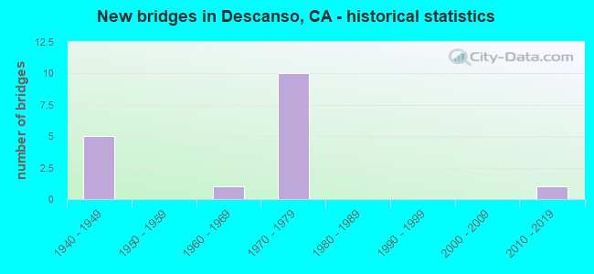
- New bridges - historical statistics
- 51940-1949
- 11960-1969
- 101970-1979
- 12010-2019


- Bridge Condition - Deck
- 78.6%Good
- 7.1%Satisfactory
- 14.3%Fair

- Bridge Condition - Superstructure
- 85.7%Good
- 7.1%Satisfactory
- 7.1%Fair

- Bridge Condition - Channel
- 12.5%Excellent
- 37.5%Very good
- 37.5%Good
- 12.5%Satisfactory
Find on map >> Show street view
Structure Number: 57 0055, Location: 11-SD-079-0.12 (Lat: 32.853989, Lng: -116.595389), Route carried "on" structure: State highway 79, Year Built: 1946, Status: Open, Structure Length: 3.08m (10.10ft), Average Daily Traffic: 2,500 (year 2012), Truck Traffic: 1%, Average Future Daily Traffic: 7,702 (year 2040), Design Load: HS 20, Features Intersected: SAMAGATUMA CREEK
Minimum Vertical Clearance: 30+ m (98+ ft), Kilometerpoint: 0.120, Lanes on structure: 2, Base Highway Network: Yes (, Subroute: 1), Owner: State Highway Agency, Approaching Roadway Width: 8.0m (26.2ft), Skew: 2 degrees, Material/Design: Concrete continuous, Design/Construction: Slab, Number Of Spans In Main Unit: 3, Length of Maximum Span: 11.0m (36.1ft), Curb or Sidewalk Widths: Left: 0.8m (2.6ft), Right: 0.8m (2.6ft), Curb-To-Curb Width: 8.0m (26.2ft), Out-to-Out Width: 9.6m (31.5ft)
Condition: Deck: Good, Superstructure: Good, Substructure: Good, Channel: Good, Operating Rating: 42.1 metric tons, Method Used To Determine Operating Rating: Load Factor (LF), Inventory Rating: 25.3 metric tons, Method Used To Determine Inventory Rating: Load Factor (LF), Structural Evaluation: Equal to present minimum criteria, Deck Geometry: High priority of corrective action, Waterway Adequacy: Equal to present desirable criteria, Approach Roadway Alignment: Somewhat better than minimum adequacy, Designated Inspection Frequency: Every 24 months, Inspection Date: June 2020, Deck Structure Type: Concrete Cast-file-Place, Wearing Surface/Protective System: Wearing Surface: Bituminous
Find on map >> Show street view
Structure Number: 57 0056, Location: 11-SD-079-4.97 (Lat: 32.910819, Lng: -116.574267), Route carried "on" structure: State highway 79, Year Built: 1949, Status: Open, Structure Length: 5.49m (18.01ft), Average Daily Traffic: 2,200 (year 2012), Truck Traffic: 8%, Average Future Daily Traffic: 7,000 (year 2040), Design Load: HS 20, Features Intersected: SWEETWATER RIVER
Minimum Vertical Clearance: 30+ m (98+ ft), Kilometerpoint: 4.970, Lanes on structure: 2, Base Highway Network: Yes (, Subroute: 1), Owner: State Highway Agency, Approaching Roadway Width: 8.0m (26.2ft), Skew: 1 degrees, Material/Design: Concrete continuous, Design/Construction: Tee Beam, Number Of Spans In Main Unit: 5, Length of Maximum Span: 15.8m (51.8ft), Curb or Sidewalk Widths: Left: 0.6m (2.0ft), Right: 0.6m (2.0ft), Curb-To-Curb Width: 8.0m (26.2ft), Out-to-Out Width: 9.2m (30.2ft)
Condition: Deck: Fair, Superstructure: Good, Substructure: Good, Channel: Very good, Operating Rating: 23.7 metric tons, Method Used To Determine Operating Rating: Load and Resistance Factor Rating (LRFR) rating reported by rating factor(RF) method using HL-93 loadings, Inventory Rating: 15.9 metric tons, Method Used To Determine Inventory Rating: Load and Resistance Factor Rating (LRFR) rating reported by rating factor(RF) method using HL-93 loadings, Structural Evaluation: Meets minimum limits, Deck Geometry: High priority of corrective action, Waterway Adequacy: Equal to present desirable criteria, Approach Roadway Alignment: Equal to present minimum criteria, Designated Inspection Frequency: Every 24 months, Inspection Date: June 2020, Deck Structure Type: Concrete Cast-file-Place, Wearing Surface/Protective System: Wearing Surface: Bituminous
Find on map >> Show street view
Structure Number: 57 0157, Location: 11-SD-079-2.57 (Lat: 32.882419, Lng: -116.578242), Route carried "on" structure: State highway 79, Year Built: 1946, Status: Open, Structure Length: 0.85m (2.79ft), Average Daily Traffic: 3,300 (year 2012), Truck Traffic: 1%, Average Future Daily Traffic: 5,135 (year 2040), Design Load: HS 20, Features Intersected: DESCANSO CREEK
Minimum Vertical Clearance: 30+ m (98+ ft), Kilometerpoint: 2.570, Lanes on structure: 2, Base Highway Network: Yes (, Subroute: 1), Owner: State Highway Agency, Approaching Roadway Width: 8.0m (26.2ft), Skew: 3 degrees, Material/Design: Concrete, Design/Construction: Slab, Number Of Spans In Main Unit: 1, Length of Maximum Span: 8.2m (26.9ft), Curb or Sidewalk Widths: Left: 0.6m (2.0ft), Right: 0.6m (2.0ft), Curb-To-Curb Width: 8.0m (26.2ft), Out-to-Out Width: 9.2m (30.2ft)
Condition: Deck: Good, Superstructure: Good, Substructure: Good, Channel: Good, Operating Rating: 38.9 metric tons, Method Used To Determine Operating Rating: Load Factor (LF), Inventory Rating: 23.3 metric tons, Method Used To Determine Inventory Rating: Load Factor (LF), Structural Evaluation: Equal to present minimum criteria, Deck Geometry: High priority of corrective action, Waterway Adequacy: Equal to present desirable criteria, Approach Roadway Alignment: Equal to present minimum criteria, Designated Inspection Frequency: Every 24 months, Inspection Date: June 2020, Deck Structure Type: Concrete Cast-file-Place, Wearing Surface/Protective System: Wearing Surface: Bituminous
Find on map >> Show street view
Structure Number: 57 0688L, Location: 11-SD-008-R36.53 (Lat: 32.837022, Lng: -116.643983), Route carried "on" structure: Interstate 8, Year Built: 1970, Status: Open, Structure Length: 17.07m (56.00ft), Average Daily Traffic: 11,050 (year 2010), Truck Traffic: 12%, Average Future Daily Traffic: 20,953 (year 2044), Design Load: HS 20, Features Intersected: SWEETWATER RIVER
Minimum Vertical Clearance: 30+ m (98+ ft), Kilometerpoint: 36.530, Lanes on structure: 2, Base Highway Network: Yes (, Subroute: 1), Owner: State Highway Agency, Approaching Roadway Width: 11.9m (39.0ft), Material/Design: Steel continuous, Design/Construction: Stringer/Multi-beam, Number Of Spans In Main Unit: 3, Length of Maximum Span: 64.9m (212.9ft), Curb-To-Curb Width: 11.9m (39.0ft), Out-to-Out Width: 12.5m (41.0ft)
Condition: Deck: Good, Superstructure: Good, Substructure: Good, Channel: Very good, Operating Rating: 19.1 metric tons, Method Used To Determine Operating Rating: Load and Resistance Factor Rating (LRFR) rating reported by rating factor(RF) method using HL-93 loadings, Inventory Rating: 14.6 metric tons, Method Used To Determine Inventory Rating: Load and Resistance Factor Rating (LRFR) rating reported by rating factor(RF) method using HL-93 loadings, Structural Evaluation: High priority of corrective action, Deck Geometry: Equal to present minimum criteria, Waterway Adequacy: Superior to present desirable criteria, Approach Roadway Alignment: Equal to present desirable criteria, Designated Inspection Frequency: Every 24 months, Critical Feature Inspection Frequency: Every 24 months, Inspection Date: January 2022, Critical Feature Inspection Date: January 2021, Deck Structure Type: Concrete Cast-file-Place, Wearing Surface/Protective System: Wearing Surface: Other
Find on map >> Show street view
Structure Number: 57 0688R, Location: 11-SD-008-R36.50 (Lat: 32.836764, Lng: -116.644458), Route carried "on" structure: Interstate 8, Year Built: 1970, Status: Open, Structure Length: 19.20m (62.99ft), Average Daily Traffic: 11,050 (year 2010), Truck Traffic: 12%, Average Future Daily Traffic: 20,953 (year 2044), Design Load: HS 20, Features Intersected: SWEETWATER RIVER
Minimum Vertical Clearance: 30+ m (98+ ft), Kilometerpoint: 36.500, Lanes on structure: 3, Base Highway Network: Yes (, Subroute: 1), Owner: State Highway Agency, Approaching Roadway Width: 15.6m (51.2ft), Material/Design: Steel continuous, Design/Construction: Stringer/Multi-beam, Number Of Spans In Main Unit: 3, Length of Maximum Span: 73.5m (241.1ft), Curb-To-Curb Width: 15.6m (51.2ft), Out-to-Out Width: 16.2m (53.1ft)
Condition: Deck: Good, Superstructure: Good, Substructure: Good, Channel: Very good, Operating Rating: 22.7 metric tons, Method Used To Determine Operating Rating: Load and Resistance Factor Rating (LRFR) rating reported by rating factor(RF) method using HL-93 loadings, Inventory Rating: 17.5 metric tons, Method Used To Determine Inventory Rating: Load and Resistance Factor Rating (LRFR) rating reported by rating factor(RF) method using HL-93 loadings, Structural Evaluation: Meets minimum limits, Deck Geometry: Somewhat better than minimum adequacy, Waterway Adequacy: Superior to present desirable criteria, Approach Roadway Alignment: Equal to present desirable criteria, Designated Inspection Frequency: Every 24 months, Critical Feature Inspection Frequency: Every 24 months, Inspection Date: January 2022, Critical Feature Inspection Date: January 2021, Deck Structure Type: Concrete Cast-file-Place, Wearing Surface/Protective System: Wearing Surface: Other
Find on map >> Show street view
Structure Number: 57 0689L, Location: 11-SD-008-R37.83 (Lat: 32.827403, Lng: -116.625461), Route carried "on" structure: Interstate 8, Year Built: 1970, Status: Open, Structure Length: 4.08m (13.39ft), Average Daily Traffic: 11,050 (year 2010), Truck Traffic: 12%, Average Future Daily Traffic: 20,953 (year 2044), Design Load: HS 20, Features Intersected: STATE ROUTE 79
Minimum Vertical Clearance: 30+ m (98+ ft), Kilometerpoint: 37.830, Lanes on structure: 2, Lanes under structure: 2, Base Highway Network: Yes (, Subroute: 1), Owner: State Highway Agency, Approaching Roadway Width: 11.9m (39.0ft), Skew: 2 degrees, Material/Design: Prestressed concrete, Design/Construction: Box Beam or Girders - Multiple, Number Of Spans In Main Unit: 1, Length of Maximum Span: 40.2m (131.9ft), Curb-To-Curb Width: 11.9m (39.0ft), Out-to-Out Width: 12.5m (41.0ft)
Condition: Deck: Good, Superstructure: Good, Substructure: Good, Operating Rating: 61.6 metric tons, Method Used To Determine Operating Rating: Load and Resistance Factor Rating (LRFR) rating reported by rating factor(RF) method using HL-93 loadings, Inventory Rating: 39.9 metric tons, Method Used To Determine Inventory Rating: Load and Resistance Factor Rating (LRFR) rating reported by rating factor(RF) method using HL-93 loadings, Structural Evaluation: Better than present minimum criteria, Deck Geometry: Equal to present minimum criteria, Underclear: Equal to present minimum criteria, Approach Roadway Alignment: Equal to present desirable criteria, Designated Inspection Frequency: Every 24 months, Inspection Date: January 2022, Deck Structure Type: Concrete Cast-file-Place, Wearing Surface/Protective System: Wearing Surface: Integral Concrete
Find on map >> Show street view
Structure Number: 57 0689R, Location: 11-SD-008-R37.83 (Lat: 32.827022, Lng: -116.625672), Route carried "on" structure: Interstate 8, Year Built: 1970, Status: Open, Structure Length: 4.42m (14.50ft), Average Daily Traffic: 11,050 (year 2010), Truck Traffic: 12%, Average Future Daily Traffic: 20,953 (year 2044), Design Load: HS 20, Features Intersected: STATE ROUTE 79
Minimum Vertical Clearance: 30+ m (98+ ft), Kilometerpoint: 37.830, Lanes on structure: 3, Lanes under structure: 2, Base Highway Network: Yes (, Subroute: 1), Owner: State Highway Agency, Approaching Roadway Width: 15.6m (51.2ft), Skew: 2 degrees, Material/Design: Prestressed concrete, Design/Construction: Box Beam or Girders - Multiple, Number Of Spans In Main Unit: 1, Length of Maximum Span: 43.6m (143.0ft), Curb-To-Curb Width: 15.6m (51.2ft), Out-to-Out Width: 16.2m (53.1ft)
Condition: Deck: Good, Superstructure: Good, Substructure: Good, Operating Rating: 49.9 metric tons, Method Used To Determine Operating Rating: Load and Resistance Factor Rating (LRFR) rating reported by rating factor(RF) method using HL-93 loadings, Inventory Rating: 37.3 metric tons, Method Used To Determine Inventory Rating: Load and Resistance Factor Rating (LRFR) rating reported by rating factor(RF) method using HL-93 loadings, Structural Evaluation: Better than present minimum criteria, Deck Geometry: Somewhat better than minimum adequacy, Underclear: Equal to present minimum criteria, Approach Roadway Alignment: Equal to present desirable criteria, Designated Inspection Frequency: Every 24 months, Inspection Date: January 2022, Deck Structure Type: Concrete Cast-file-Place, Wearing Surface/Protective System: Wearing Surface: Integral Concrete
Find on map >> Show street view
Structure Number: 57 0690L, Location: 11-SD-008-R39.62L (Lat: 32.822619, Lng: -116.596197), Route carried "on" structure: Interstate 8, Year Built: 1974, Status: Open, Structure Length: 2.32m (7.61ft), Average Daily Traffic: 8,900 (year 2010), Truck Traffic: 13%, Average Future Daily Traffic: 13,620 (year 2044), Design Load: HS 20, Features Intersected: HORSETHIEF RD
Minimum Vertical Clearance: 30+ m (98+ ft), Kilometerpoint: 39.620, Lanes on structure: 2, Lanes under structure: 1, Base Highway Network: Yes (, Subroute: 1), Owner: State Highway Agency, Approaching Roadway Width: 12.2m (40.0ft), Material/Design: Prestressed concrete, Design/Construction: Box Beam or Girders - Multiple, Number Of Spans In Main Unit: 1, Length of Maximum Span: 23.2m (76.1ft), Curb-To-Curb Width: 12.2m (40.0ft), Out-to-Out Width: 12.8m (42.0ft)
Condition: Deck: Good, Superstructure: Good, Substructure: Good, Operating Rating: 63.2 metric tons, Method Used To Determine Operating Rating: Load and Resistance Factor Rating (LRFR) rating reported by rating factor(RF) method using HL-93 loadings, Inventory Rating: 48.6 metric tons, Method Used To Determine Inventory Rating: Load and Resistance Factor Rating (LRFR) rating reported by rating factor(RF) method using HL-93 loadings, Structural Evaluation: Better than present minimum criteria, Deck Geometry: Better than present minimum criteria, Underclear: Meets minimum limits, Approach Roadway Alignment: Equal to present desirable criteria, Designated Inspection Frequency: Every 24 months, Inspection Date: January 2022, Deck Structure Type: Concrete Cast-file-Place
Find on map >> Show street view
Structure Number: 57 0690R, Location: 11-SD-008-R39.66R (Lat: 32.821994, Lng: -116.596364), Route carried "on" structure: Interstate 8, Year Built: 1974, Status: Open, Structure Length: 2.93m (9.61ft), Average Daily Traffic: 9,800 (year 2010), Truck Traffic: 13%, Average Future Daily Traffic: 27,240 (year 2044), Design Load: HS 20, Features Intersected: HORSETHIEF RD
Minimum Vertical Clearance: 30+ m (98+ ft), Kilometerpoint: 39.660, Lanes on structure: 3, Lanes under structure: 1, Base Highway Network: Yes (, Subroute: 1), Owner: State Highway Agency, Approaching Roadway Width: 15.9m (52.2ft), Material/Design: Prestressed concrete, Design/Construction: Box Beam or Girders - Multiple, Number Of Spans In Main Unit: 1, Length of Maximum Span: 29.3m (96.1ft), Curb-To-Curb Width: 15.9m (52.2ft), Out-to-Out Width: 16.5m (54.1ft)
Condition: Deck: Good, Superstructure: Good, Substructure: Good, Operating Rating: 47.3 metric tons, Method Used To Determine Operating Rating: Load and Resistance Factor Rating (LRFR) rating reported by rating factor(RF) method using HL-93 loadings, Inventory Rating: 36.3 metric tons, Method Used To Determine Inventory Rating: Load and Resistance Factor Rating (LRFR) rating reported by rating factor(RF) method using HL-93 loadings, Structural Evaluation: Better than present minimum criteria, Deck Geometry: Somewhat better than minimum adequacy, Underclear: Meets minimum limits, Approach Roadway Alignment: Equal to present desirable criteria, Designated Inspection Frequency: Every 24 months, Inspection Date: January 2022, Deck Structure Type: Concrete Cast-file-Place
Find on map >> Show street view
Structure Number: 57 0691L, Location: 11-SD-008-R40.84L (Lat: 32.820378, Lng: -116.576839), Route carried "on" structure: Interstate 8, Year Built: 1974, Status: Open, Structure Length: 2.56m (8.40ft), Average Daily Traffic: 9,800 (year 2010), Truck Traffic: 20%, Average Future Daily Traffic: 16,461 (year 2044), Design Load: HS 20, Features Intersected: LAS BANCAS RD
Minimum Vertical Clearance: 30+ m (98+ ft), Kilometerpoint: 40.840, Lanes on structure: 3, Lanes under structure: 1, Base Highway Network: Yes (, Subroute: 1), Owner: State Highway Agency, Approaching Roadway Width: 15.9m (52.2ft), Skew: 1 degrees, Material/Design: Concrete, Design/Construction: Box Beam or Girders - Multiple, Number Of Spans In Main Unit: 1, Length of Maximum Span: 25.6m (84.0ft), Curb-To-Curb Width: 15.9m (52.2ft), Out-to-Out Width: 16.5m (54.1ft)
Condition: Deck: Good, Superstructure: Good, Substructure: Good, Operating Rating: 68.0 metric tons, Method Used To Determine Operating Rating: Load and Resistance Factor Rating (LRFR) rating reported by rating factor(RF) method using HL-93 loadings, Inventory Rating: 49.6 metric tons, Method Used To Determine Inventory Rating: Load and Resistance Factor Rating (LRFR) rating reported by rating factor(RF) method using HL-93 loadings, Structural Evaluation: Better than present minimum criteria, Deck Geometry: Somewhat better than minimum adequacy, Underclear: Meets minimum limits, Approach Roadway Alignment: Equal to present desirable criteria, Designated Inspection Frequency: Every 24 months, Inspection Date: January 2022, Deck Structure Type: Concrete Cast-file-Place
Find on map >> Show street view
Structure Number: 57 0691R, Location: 11-SD-008-R40.84R (Lat: 32.819197, Lng: -116.576831), Route carried "on" structure: Interstate 8, Year Built: 1974, Status: Open, Structure Length: 2.23m (7.32ft), Average Daily Traffic: 9,800 (year 2010), Truck Traffic: 13%, Average Future Daily Traffic: 27,240 (year 2044), Design Load: HS 20, Features Intersected: LAS BANCAS RD
Minimum Vertical Clearance: 30+ m (98+ ft), Kilometerpoint: 40.840, Lanes on structure: 3, Lanes under structure: 1, Base Highway Network: Yes (, Subroute: 1), Owner: State Highway Agency, Approaching Roadway Width: 15.9m (52.2ft), Material/Design: Concrete, Design/Construction: Box Beam or Girders - Multiple, Number Of Spans In Main Unit: 1, Length of Maximum Span: 22.3m (73.2ft), Curb-To-Curb Width: 15.9m (52.2ft), Out-to-Out Width: 16.5m (54.1ft)
Condition: Deck: Good, Superstructure: Good, Substructure: Good, Operating Rating: 79.4 metric tons, Method Used To Determine Operating Rating: Load and Resistance Factor Rating (LRFR) rating reported by rating factor(RF) method using HL-93 loadings, Inventory Rating: 61.2 metric tons, Method Used To Determine Inventory Rating: Load and Resistance Factor Rating (LRFR) rating reported by rating factor(RF) method using HL-93 loadings, Structural Evaluation: Better than present minimum criteria, Deck Geometry: Somewhat better than minimum adequacy, Underclear: Meets minimum limits, Approach Roadway Alignment: Equal to present desirable criteria, Designated Inspection Frequency: Every 24 months, Inspection Date: January 2022, Deck Structure Type: Concrete Cast-file-Place
Find on map >> Show street view
Structure Number: 57C0345, Location: 0.9 MI NW/O SR 79 (Lat: 32.857700, Lng: -116.608064), Route carried "on" structure: County highway , Year Built: 1942, Status: Open, Structure Length: 0.79m (2.59ft), Average Daily Traffic: 1,600 (year 2016), Truck Traffic: 2%, Average Future Daily Traffic: 1,650 (year 2038), Features Intersected: DESCANSO CREEK, Facility Carried by Structure: VIEJAS BLVD
Minimum Vertical Clearance: 30+ m (98+ ft), Kilometerpoint: 0.000, Lanes on structure: 2, Owner: County Highway Agency, Approaching Roadway Width: 9.1m (29.9ft), Material/Design: Concrete, Design/Construction: Tee Beam, Number Of Spans In Main Unit: 1, Length of Maximum Span: 7.3m (24.0ft), Curb or Sidewalk Widths: Left: 0.2m (0.7ft), Right: 0.2m (0.7ft), Curb-To-Curb Width: 6.2m (20.3ft), Out-to-Out Width: 6.8m (22.3ft)
Condition: Deck: Good, Superstructure: Good, Substructure: Good, Channel: Satisfactory, Operating Rating: 28.8 metric tons, Method Used To Determine Operating Rating: Field evaluation and documented engineering judgment, Inventory Rating: 17.2 metric tons, Method Used To Determine Inventory Rating: Field evaluation and documented engineering judgment, Structural Evaluation: Meets minimum limits, Deck Geometry: High priority of replacement, Waterway Adequacy: Equal to present minimum criteria, Approach Roadway Alignment: Equal to present desirable criteria, Designated Inspection Frequency: Every 24 months, Inspection Date: April 2021, Deck Structure Type: Concrete Cast-file-Place, Wearing Surface/Protective System: Wearing Surface: Bituminous
Find on map >> Show street view
Structure Number: 57C0371, Location: 0.3 MI N/O SR 79 (Lat: 32.845722, Lng: -116.612992), Route carried "on" structure: County highway , Year Built: 1947, Status: Open, Structure Length: 5.58m (18.31ft), Average Daily Traffic: 2,500 (year 2016), Truck Traffic: 1%, Average Future Daily Traffic: 2,634 (year 2038), Design Load: H 15, Features Intersected: SWEETWATER RIVER, Facility Carried by Structure: RIVERSIDE DR
Minimum Vertical Clearance: 30+ m (98+ ft), Kilometerpoint: 0.000, Lanes on structure: 2, Owner: County Highway Agency, Approaching Roadway Width: 7.6m (24.9ft), Skew: 3 degrees, Material/Design: Concrete continuous, Design/Construction: Slab, Number Of Spans In Main Unit: 6, Length of Maximum Span: 8.5m (27.9ft), Curb or Sidewalk Widths: Left: 0.5m (1.6ft), Right: 0.5m (1.6ft), Curb-To-Curb Width: 7.3m (24.0ft), Out-to-Out Width: 8.1m (26.6ft)
Condition: Deck: Satisfactory, Superstructure: Satisfactory, Substructure: Good, Channel: Good, Operating Rating: 36.6 metric tons, Method Used To Determine Operating Rating: Field evaluation and documented engineering judgment, Inventory Rating: 22.0 metric tons, Method Used To Determine Inventory Rating: Field evaluation and documented engineering judgment, Structural Evaluation: Somewhat better than minimum adequacy, Deck Geometry: High priority of replacement, Waterway Adequacy: Equal to present desirable criteria, Approach Roadway Alignment: Meets minimum limits, Designated Inspection Frequency: Every 24 months, Inspection Date: April 2021, Deck Structure Type: Concrete Cast-file-Place
Find on map >> Show street view
Structure Number: 57C0717, Location: 100 FT S/O RIVER DRIVE (Lat: 32.857869, Lng: -116.614108), Route carried "on" structure: County highway , Year Built: 2010, Status: Open, Structure Length: 3.81m (12.50ft), Average Daily Traffic: 400 (year 2016), Truck Traffic: 1%, Average Future Daily Traffic: 457 (year 2038), Design Load: HS 20+Mod, Features Intersected: SWEETWATER RIVER, Facility Carried by Structure: VIEJAS BOULEVARD
Minimum Vertical Clearance: 30+ m (98+ ft), Kilometerpoint: 0.000, Lanes on structure: 2, Owner: County Highway Agency, Approaching Roadway Width: 11.0m (36.1ft), Material/Design: Prestressed concrete continuous, Design/Construction: Slab, Number Of Spans In Main Unit: 3, Length of Maximum Span: 16.1m (52.8ft), Curb or Sidewalk Widths: Left: 1.5m (4.9ft), Right: 0.0m, Curb-To-Curb Width: 11.0m (36.1ft), Out-to-Out Width: 13.9m (45.6ft)
Condition: Deck: Fair, Superstructure: Fair, Substructure: Good, Channel: Excellent, Operating Rating: 54.1 metric tons, Method Used To Determine Operating Rating: Assigned rating based on Load Factor Design (LFD) reported in metric tons, Inventory Rating: 32.4 metric tons, Method Used To Determine Inventory Rating: Assigned rating based on Load Factor Design (LFD) reported in metric tons, Structural Evaluation: Somewhat better than minimum adequacy, Deck Geometry: Equal to present desirable criteria, Waterway Adequacy: Equal to present desirable criteria, Approach Roadway Alignment: Equal to present desirable criteria, Designated Inspection Frequency: Every 24 months, Inspection Date: April 2021, Deck Structure Type: Concrete Cast-file-Place, Wearing Surface/Protective System: Deck Protection: Epoxy Coated Reinforcing
Find on map >> Show street view
Structure Number: 57 063, Location: 11-SD-008-R34.33 (Lat: 32.838536, Lng: -116.681169), Route carried "under" structure: Interstate 8, Year Built: 1969, Structure Length: 0. m, Average Daily Traffic: 22,100 (year 2010), Truck Traffic: 12%, Features Intersected: INTERSTATE 8, Facility Carried by Structure: WILLOWS RD
Minimum Vertical Clearance: 5.15m (16.90ft), Kilometerpoint: 34.330, Lanes on structure: 2, Lanes under structure: 5, Material/Design: Concrete continuous, Design/Construction: Box Beam or Girders - Multiple, Length of Maximum Span: 41.1m (134.8ft)
Find on map >> Show street view
Structure Number: 57 0689L, Location: 11-SD-008-R37.83 (Lat: 32.827403, Lng: -116.625461), Route carried "under" structure: State highway 79, Year Built: 1970, Structure Length: 0. m, Average Daily Traffic: 2,500 (year 2010), Truck Traffic: 1%, Features Intersected: STATE ROUTE 79, Facility Carried by Structure: INTERSTATE 8 WB
Minimum Vertical Clearance: 5.31m (17.42ft), Kilometerpoint: 0.050, Lanes on structure: 2, Lanes under structure: 2, Material/Design: Prestressed concrete, Design/Construction: Box Beam or Girders - Multiple, Length of Maximum Span: 40.2m (131.9ft)
Find on map >> Show street view
Structure Number: 57 0689R, Location: 11-SD-008-R37.83 (Lat: 32.827022, Lng: -116.625672), Route carried "under" structure: State highway 79, Year Built: 1970, Structure Length: 0. m, Average Daily Traffic: 2,500 (year 2010), Truck Traffic: 9%, Features Intersected: STATE ROUTE 79, Facility Carried by Structure: INTERSTATE 8 EB
Minimum Vertical Clearance: 5.94m (19.49ft), Kilometerpoint: 0.050, Lanes on structure: 3, Lanes under structure: 2, Material/Design: Prestressed concrete, Design/Construction: Box Beam or Girders - Multiple, Length of Maximum Span: 43.6m (143.0ft)