Bridge Statistics for Ellicott, Colorado (CO)
Condition, Traffic, Stress, Structural Evaluation, Project Costs
- National Bridge Inventory (NBI) Statistics
- 11Number of bridges
- 92ft / 27.8mTotal length
- 12,205Total average daily traffic
- 890Total average daily truck traffic
- 15,209Total future (year 2040) average daily traffic
- National Bridge Inventory (NBI) Registered Bridges for Ellicott
- No street view available for this location
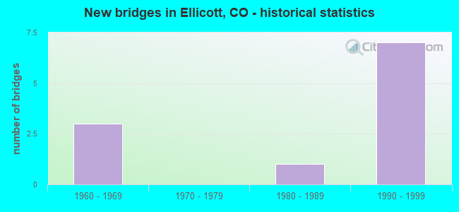
- New bridges - historical statistics
- 31960-1969
- 11980-1989
- 71990-1999


- Bridge Condition - Deck
- 28.6%Very good
- 14.3%Good
- 42.9%Satisfactory
- 14.3%Fair

- Bridge Condition - Superstructure
- 57.1%Good
- 28.6%Satisfactory
- 14.3%Fair

- Bridge Condition - Substructure
- 71.4%Good
- 14.3%Fair
- 14.3%Poor

- Bridge Condition - Channel
- 27.3%Very good
- 45.5%Good
- 18.2%Satisfactory
- 9.1%Poor

- Bridge Condition - Culverts
- 25.0%Good
- 75.0%Satisfactory
Find on map >> Show street view
Structure Number: EPC0450-00.77A, Location: .33 MI W OF ELLICOTT HWY (Lat: 38.823889, Lng: -104.391389), Route carried "on" structure: County highway , Year Built: 1991, Status: Open, Structure Length: 0.99m (3.25ft), Average Daily Traffic: 68 (year 2021), Truck Traffic: 4%, Average Future Daily Traffic: 89 (year 2041), Design Load: HS 20, Features Intersected: SQUIRREL CREEK, Facility Carried by Structure: HANDLE ROAD
Minimum Vertical Clearance: 30+ m (98+ ft), Kilometerpoint: 1.664, Lanes on structure: 2, Owner: County Highway Agency, Approaching Roadway Width: 7.2m (23.6ft), Material/Design: Steel, Design/Construction: Culvert, Number Of Spans In Main Unit: 4, Length of Maximum Span: 1.8m (5.9ft), Out-to-Out Width: 21.3m (69.9ft)
Condition: Channel: Good, Culverts: Good, Structural Evaluation: Better than present minimum criteria, Waterway Adequacy: Equal to present desirable criteria, Approach Roadway Alignment: Equal to present desirable criteria, Designated Inspection Frequency: Every 24 months, Inspection Date: Febuary 2020
Find on map >> Show street view
Structure Number: EPC0450-03.18A, Location: 2.25 MI E OF ELLICOTT HWY (Lat: 38.824167, Lng: -104.345833), Route carried "on" structure: County highway , Year Built: 1991, Status: Open, Structure Length: 0.82m (2.69ft), Average Daily Traffic: 53 (year 2021), Truck Traffic: 4%, Average Future Daily Traffic: 70 (year 2041), Design Load: HS 20, Features Intersected: SPRING CREEK, Facility Carried by Structure: HANDLE ROAD
Minimum Vertical Clearance: 30+ m (98+ ft), Kilometerpoint: 5.633, Lanes on structure: 2, Owner: County Highway Agency, Approaching Roadway Width: 8.2m (26.9ft), Material/Design: Steel, Design/Construction: Culvert, Number Of Spans In Main Unit: 4, Length of Maximum Span: 1.5m (4.9ft), Out-to-Out Width: 19.8m (65.0ft)
Condition: Channel: Satisfactory, Culverts: Satisfactory, Structural Evaluation: Equal to present minimum criteria, Waterway Adequacy: Equal to present desirable criteria, Approach Roadway Alignment: Equal to present desirable criteria, Designated Inspection Frequency: Every 24 months, Inspection Date: Febuary 2020
Find on map >> Show street view
Structure Number: EPC0463-19.90A, Location: 2.1 MI SOUTH OF SH 94 (Lat: 38.806389, Lng: -104.460833), Route carried "on" structure: County highway , Year Built: 1994, Status: Open, Structure Length: 3.09m (10.14ft), Average Daily Traffic: 416 (year 2021), Truck Traffic: 9%, Average Future Daily Traffic: 545 (year 2041), Design Load: HS 20, Features Intersected: W FK BLK SQUIRREL CK, Facility Carried by Structure: PEYTON HIGHWAY
Minimum Vertical Clearance: 30+ m (98+ ft), Kilometerpoint: 32.734, Lanes on structure: 2, Owner: County Highway Agency, Approaching Roadway Width: 7.9m (25.9ft), Material/Design: Steel continuous, Design/Construction: Stringer/Multi-beam, Number Of Spans In Main Unit: 2, Length of Maximum Span: 15.1m (49.5ft), Curb-To-Curb Width: 10.9m (35.8ft), Out-to-Out Width: 11.0m (36.1ft)
Condition: Deck: Very good, Superstructure: Good, Substructure: Good, Channel: Good, Operating Rating: 41.6 metric tons, Method Used To Determine Operating Rating: Load Factor (LF), Inventory Rating: 24.9 metric tons, Method Used To Determine Inventory Rating: Load Factor (LF), Structural Evaluation: Equal to present minimum criteria, Deck Geometry: Equal to present minimum criteria, Waterway Adequacy: Equal to present minimum criteria, Approach Roadway Alignment: Equal to present desirable criteria, Designated Inspection Frequency: Every 24 months, Inspection Date: Febuary 2020, Deck Structure Type: Corrugated Steel, Wearing Surface/Protective System: Wearing Surface: Bituminous
Find on map >> Show street view
Structure Number: EPC0463-20.00A, Location: 2.0 MI SOUTH OF SH 94 (Lat: 38.807778, Lng: -104.460833), Route carried "on" structure: County highway , Year Built: 1994, Status: Open, Structure Length: 5.09m (16.70ft), Average Daily Traffic: 413 (year 2021), Truck Traffic: 9%, Average Future Daily Traffic: 542 (year 2041), Design Load: HS 20, Features Intersected: W FK BLACK SQUIRREL CK, Facility Carried by Structure: PEYTON HIGHWAY
Minimum Vertical Clearance: 30+ m (98+ ft), Kilometerpoint: 32.888, Lanes on structure: 2, Owner: County Highway Agency, Approaching Roadway Width: 7.9m (25.9ft), Skew: 3 degrees, Material/Design: Steel continuous, Design/Construction: Stringer/Multi-beam, Number Of Spans In Main Unit: 3, Length of Maximum Span: 19.1m (62.7ft), Curb-To-Curb Width: 11.0m (36.1ft), Out-to-Out Width: 11.0m (36.1ft)
Condition: Deck: Very good, Superstructure: Good, Substructure: Good, Channel: Very good, Operating Rating: 37.4 metric tons, Method Used To Determine Operating Rating: Load Factor (LF), Inventory Rating: 22.4 metric tons, Method Used To Determine Inventory Rating: Load Factor (LF), Structural Evaluation: Equal to present minimum criteria, Deck Geometry: Better than present minimum criteria, Waterway Adequacy: Equal to present desirable criteria, Approach Roadway Alignment: Equal to present desirable criteria, Designated Inspection Frequency: Every 24 months, Inspection Date: Febuary 2020, Deck Structure Type: Corrugated Steel, Wearing Surface/Protective System: Wearing Surface: Bituminous
Find on map >> Show street view
Structure Number: EPC0475-00.50A, Location: 0.5 MI S OF JONES ROAD (Lat: 38.889167, Lng: -104.443056), Route carried "on" structure: County highway , Year Built: 1992, Status: Open, Structure Length: 0.69m (2.26ft), Average Daily Traffic: 37 (year 2021), Average Future Daily Traffic: 48 (year 2041), Design Load: HS 20, Features Intersected: SQUIRREL CREEK, Facility Carried by Structure: J.D. JOHNSON RD
Minimum Vertical Clearance: 30+ m (98+ ft), Kilometerpoint: 0.820, Lanes on structure: 2, Owner: County Highway Agency, Approaching Roadway Width: 7.0m (23.0ft), Skew: 3 degrees, Material/Design: Concrete, Design/Construction: Culvert, Number Of Spans In Main Unit: 3, Length of Maximum Span: 1.8m (5.9ft), Out-to-Out Width: 19.0m (62.3ft)
Condition: Channel: Good, Culverts: Satisfactory, Operating Rating: 36.3 metric tons, Method Used To Determine Operating Rating: Field evaluation and documented engineering judgment, Inventory Rating: 32.7 metric tons, Method Used To Determine Inventory Rating: Field evaluation and documented engineering judgment, Structural Evaluation: Equal to present minimum criteria, Waterway Adequacy: Better than present minimum criteria, Approach Roadway Alignment: Equal to present desirable criteria, Designated Inspection Frequency: Every 24 months, Inspection Date: Febuary 2020
Find on map >> Show street view
Structure Number: EPC0483-03.80A, Location: 2.0 MI S OF JONES ROAD (Lat: 38.867222, Lng: -104.421667), Route carried "on" structure: County highway , Year Built: 1997, Status: Open, Structure Length: 1.85m (6.07ft), Average Daily Traffic: 65 (year 2021), Average Future Daily Traffic: 85 (year 2041), Design Load: HS 20, Features Intersected: SQUIRREL CREEK, Facility Carried by Structure: LOG ROAD
Minimum Vertical Clearance: 30+ m (98+ ft), Kilometerpoint: 6.208, Lanes on structure: 2, Owner: County Highway Agency, Approaching Roadway Width: 7.6m (24.9ft), Material/Design: Steel, Design/Construction: Stringer/Multi-beam, Number Of Spans In Main Unit: 2, Length of Maximum Span: 8.7m (28.5ft), Curb-To-Curb Width: 9.2m (30.2ft), Out-to-Out Width: 9.2m (30.2ft)
Condition: Deck: Satisfactory, Superstructure: Satisfactory, Substructure: Good, Channel: Good, Operating Rating: 67.9 metric tons, Method Used To Determine Operating Rating: Load Factor (LF), Inventory Rating: 40.7 metric tons, Method Used To Determine Inventory Rating: Load Factor (LF), Structural Evaluation: Equal to present minimum criteria, Deck Geometry: Better than present minimum criteria, Waterway Adequacy: Equal to present desirable criteria, Approach Roadway Alignment: Equal to present desirable criteria, Designated Inspection Frequency: Every 24 months, Inspection Date: Febuary 2020, Deck Structure Type: Corrugated Steel, Wearing Surface/Protective System: Wearing Surface: Gravel
Find on map >> Show street view
Structure Number: EPC0483-06.10A, Location: 0.1 MI N OF JONES ROAD (Lat: 38.897778, Lng: -104.424167), Route carried "on" structure: County highway , Year Built: 1997, Status: Open, Structure Length: 1.85m (6.07ft), Average Daily Traffic: 55 (year 2021), Average Future Daily Traffic: 72 (year 2041), Design Load: HS 20, Features Intersected: SQUIRREL CREEK, Facility Carried by Structure: LOG ROAD
Minimum Vertical Clearance: 30+ m (98+ ft), Kilometerpoint: 9.852, Lanes on structure: 2, Owner: County Highway Agency, Approaching Roadway Width: 7.9m (25.9ft), Material/Design: Steel continuous, Design/Construction: Stringer/Multi-beam, Number Of Spans In Main Unit: 2, Length of Maximum Span: 8.5m (27.9ft), Curb-To-Curb Width: 9.2m (30.2ft), Out-to-Out Width: 9.2m (30.2ft)
Condition: Deck: Good, Superstructure: Good, Substructure: Good, Channel: Good, Operating Rating: 68.1 metric tons, Method Used To Determine Operating Rating: Load Factor (LF), Inventory Rating: 40.8 metric tons, Method Used To Determine Inventory Rating: Load Factor (LF), Structural Evaluation: Better than present minimum criteria, Deck Geometry: Better than present minimum criteria, Waterway Adequacy: Equal to present desirable criteria, Approach Roadway Alignment: Equal to present desirable criteria, Designated Inspection Frequency: Every 24 months, Inspection Date: March 2020, Deck Structure Type: Corrugated Steel, Wearing Surface/Protective System: Wearing Surface: Bituminous
Find on map >> Show street view
Structure Number: EPC0493-11.77, Location: 1.75 MI N OF ELLICOTT (Lat: 38.862500, Lng: -104.387500), Route carried "on" structure: County highway , Year Built: 1965, Status: Open, Structure Length: 4.41m (14.47ft), Average Daily Traffic: 1,798 (year 2021), Truck Traffic: 9%, Average Future Daily Traffic: 2,355 (year 2041), Features Intersected: SQUIRREL CREEK, Facility Carried by Structure: ELLICOTT HWY
Minimum Vertical Clearance: 30+ m (98+ ft), Kilometerpoint: 18.669, Lanes on structure: 2, Owner: County Highway Agency, Approaching Roadway Width: 8.5m (27.9ft), Material/Design: Prestressed concrete, Design/Construction: Tee Beam, Number Of Spans In Main Unit: 3, Length of Maximum Span: 14.2m (46.6ft), Curb-To-Curb Width: 7.3m (24.0ft), Out-to-Out Width: 9.1m (29.9ft)
Condition: Deck: Fair, Superstructure: Fair, Substructure: Fair, Channel: Satisfactory, Operating Rating: 32.3 metric tons, Method Used To Determine Operating Rating: Load Factor (LF), Inventory Rating: 20.2 metric tons, Method Used To Determine Inventory Rating: Load Factor (LF), Structural Evaluation: Somewhat better than minimum adequacy, Deck Geometry: Meets minimum limits, Waterway Adequacy: Equal to present minimum criteria, Approach Roadway Alignment: Equal to present desirable criteria, Designated Inspection Frequency: Every 24 months, Inspection Date: October 2020, Deck Structure Type: Other, Wearing Surface/Protective System: Wearing Surface: Bituminous
Find on map >> Show street view
Structure Number: I-19-AJ, Location: 1.4 MI E OF ELLICOTT (Lat: 38.838511, Lng: -104.361539), Route carried "on" structure: State highway 94A, Year Built: 1966, Status: Open, Structure Length: 4.63m (15.19ft), Average Daily Traffic: 2,800 (year 2020), Truck Traffic: 7%, Average Future Daily Traffic: 3,500 (year 2040), Design Load: HS 20+Mod, Features Intersected: BLACK SQUIRREL CREEK, Facility Carried by Structure: SH 94 ML
Minimum Vertical Clearance: 30+ m (98+ ft), Kilometerpoint: 28.804, Lanes on structure: 2, Base Highway Network: Yes, Owner: State Highway Agency, Approaching Roadway Width: 10.4m (34.1ft), Material/Design: Concrete continuous, Design/Construction: Tee Beam, Number Of Spans In Main Unit: 3, Length of Maximum Span: 18.3m (60.0ft), Curb-To-Curb Width: 9.3m (30.5ft), Out-to-Out Width: 10.1m (33.1ft)
Condition: Deck: Satisfactory, Superstructure: Good, Substructure: Good, Channel: Very good, Operating Rating: 64.0 metric tons, Method Used To Determine Operating Rating: Load Factor (LF), Inventory Rating: 38.4 metric tons, Method Used To Determine Inventory Rating: Load Factor (LF), Structural Evaluation: Better than present minimum criteria, Deck Geometry: Meets minimum limits, Waterway Adequacy: Equal to present desirable criteria, Approach Roadway Alignment: Equal to present desirable criteria, Designated Inspection Frequency: Every 24 months, Inspection Date: January 2022, Deck Structure Type: Concrete Cast-file-Place, Wearing Surface/Protective System: Wearing Surface: Bituminous, Membrane: Built-up
Find on map >> Show street view
Structure Number: I-19-AL, Location: 16.4 MI E OF JCT US 24 (Lat: 38.838178, Lng: -104.399408), Route carried "on" structure: State highway 94A, Year Built: 1982, Status: Open, Structure Length: 1.83m (6.00ft), Average Daily Traffic: 3,700 (year 2020), Truck Traffic: 7%, Average Future Daily Traffic: 4,403 (year 2040), Design Load: HS 20, Features Intersected: DRAW, Facility Carried by Structure: SH 94 ML
Minimum Vertical Clearance: 30+ m (98+ ft), Kilometerpoint: 25.523, Lanes on structure: 2, Base Highway Network: Yes, Owner: State Highway Agency, Approaching Roadway Width: 12.2m (40.0ft), Material/Design: Concrete, Design/Construction: Culvert, Number Of Spans In Main Unit: 5, Length of Maximum Span: 4.3m (14.1ft), Curb-To-Curb Width: 12.2m (40.0ft), Out-to-Out Width: 13.0m (42.7ft)
Condition: Channel: Very good, Culverts: Satisfactory, Operating Rating: 36.3 metric tons, Method Used To Determine Operating Rating: Field evaluation and documented engineering judgment, Inventory Rating: 32.7 metric tons, Method Used To Determine Inventory Rating: Field evaluation and documented engineering judgment, Structural Evaluation: Equal to present minimum criteria, Deck Geometry: Equal to present minimum criteria, Waterway Adequacy: Equal to present desirable criteria, Approach Roadway Alignment: Equal to present desirable criteria, Designated Inspection Frequency: Every 48 months, Inspection Date: January 2018
Find on map >> Show street view
Structure Number: I-19-B, Location: 2.5 MI E OF ELLICOTT (Lat: 38.838675, Lng: -104.341442), Route carried "on" structure: State highway 94A, Year Built: 1968, Status: Open, Structure Length: 2.56m (8.40ft), Average Daily Traffic: 2,800 (year 2020), Truck Traffic: 7%, Average Future Daily Traffic: 3,500 (year 2040), Design Load: HS 20, Features Intersected: BIG SPRING CREEK, Facility Carried by Structure: SH 94 ML
Minimum Vertical Clearance: 30+ m (98+ ft), Kilometerpoint: 30.545, Lanes on structure: 2, Base Highway Network: Yes, Owner: State Highway Agency, Approaching Roadway Width: 10.1m (33.1ft), Material/Design: Prestressed concrete, Design/Construction: Tee Beam, Number Of Spans In Main Unit: 1, Length of Maximum Span: 25.0m (82.0ft), Curb-To-Curb Width: 8.5m (27.9ft), Out-to-Out Width: 9.3m (30.5ft)
Condition: Deck: Satisfactory, Superstructure: Satisfactory, Substructure: Poor, Channel: Poor, Operating Rating: 45.2 metric tons, Method Used To Determine Operating Rating: Load Factor (LF), Inventory Rating: 25.8 metric tons, Method Used To Determine Inventory Rating: Load Factor (LF), Structural Evaluation: Meets minimum limits, Deck Geometry: Meets minimum limits, Waterway Adequacy: Equal to present desirable criteria, Approach Roadway Alignment: Equal to present desirable criteria, Designated Inspection Frequency: Every 24 months, Inspection Date: January 2020, Deck Structure Type: Concrete Cast-file-Place, Wearing Surface/Protective System: Wearing Surface: Bituminous, Membrane: Built-up