Bridge Statistics for Evendale, Ohio (OH)
Condition, Traffic, Stress, Structural Evaluation, Project Costs
- National Bridge Inventory (NBI) Statistics
- 19Number of bridges
- 187ft / 57.5mTotal length
- 670,738Total average daily traffic
- 90,190Total average daily truck traffic
- National Bridge Inventory (NBI) Registered Bridges for Evendale
- No street view available for this location
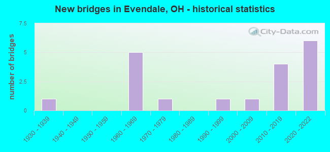
- New bridges - historical statistics
- 11930-1939
- 51960-1969
- 11970-1979
- 11990-1999
- 12000-2009
- 42010-2019
- 62020-2022
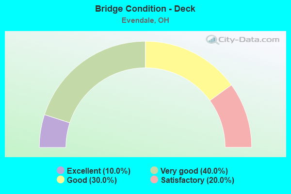
- Bridge Condition - Deck
- 10.0%Excellent
- 40.0%Very good
- 30.0%Good
- 20.0%Satisfactory
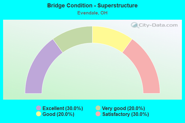
- Bridge Condition - Superstructure
- 30.0%Excellent
- 20.0%Very good
- 20.0%Good
- 30.0%Satisfactory
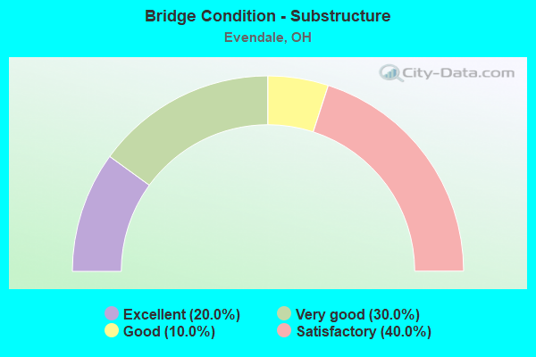
- Bridge Condition - Substructure
- 20.0%Excellent
- 30.0%Very good
- 10.0%Good
- 40.0%Satisfactory
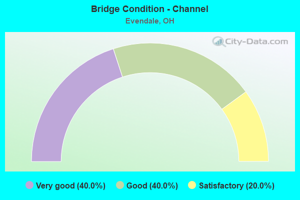
- Bridge Condition - Channel
- 40.0%Very good
- 40.0%Good
- 20.0%Satisfactory
Find on map >> Show street view
Structure Number: 3102327, Location: 0.21 MI S OF EVENDALE (Lat: 39.237569, Lng: -84.431361), Route carried "on" structure: US 42, Year Built: 1976, Status: Open, Structure Length: 1.31m (4.30ft), Average Daily Traffic: 19,000 (year 2021), Truck Traffic: 7%, Average Future Daily Traffic: 24,268 (year 2035), Design Load: HS 20+Mod, Features Intersected: TRIBUTARY MILL CREEK
Minimum Vertical Clearance: 30+ m (98+ ft), Kilometerpoint: 19.280, Lanes on structure: 4, Base Highway Network: Yes (, Subroute: 1), Owner: State Highway Agency, Approaching Roadway Width: 16.8m (55.1ft), Material/Design: Prestressed concrete, Design/Construction: Box Beam or Girders - Multiple, Number Of Spans In Main Unit: 1, Length of Maximum Span: 12.8m (42.0ft), Curb or Sidewalk Widths: Left: 1.8m (5.9ft), Right: 1.8m (5.9ft), Curb-To-Curb Width: 14.6m (47.9ft), Out-to-Out Width: 19.0m (62.3ft)
Condition: Deck: Very good, Superstructure: Very good, Substructure: Good, Channel: Satisfactory, Operating Rating: 77.1 metric tons, Method Used To Determine Operating Rating: Load Factor (LF) rating reported by rating factor (RF) method using MS18 loading, Inventory Rating: 36.3 metric tons, Method Used To Determine Inventory Rating: Load Factor (LF) rating reported by rating factor (RF) method using MS18 loading, Structural Evaluation: Better than present minimum criteria, Deck Geometry: High priority of replacement, Waterway Adequacy: Equal to present desirable criteria, Approach Roadway Alignment: Equal to present desirable criteria, Designated Inspection Frequency: Every 24 months, Inspection Date: December 2021, Deck Structure Type: Concrete Cast-file-Place, Wearing Surface/Protective System: Wearing Surface: Monolithic Concrete
Find on map >> Show street view
Structure Number: 3102343, Location: 0.18 MI S OF SR 126 JCT (Lat: 39.251700, Lng: -84.424200), Route carried "on" structure: US 42, Year Built: 1931, Status: Open, Structure Length: 0.70m (2.30ft), Average Daily Traffic: 17,484 (year 2015), Truck Traffic: 5%, Average Future Daily Traffic: 24,268 (year 2035), Design Load: H 15, Features Intersected: TRIBUTARY MILL CREEK
Minimum Vertical Clearance: 30+ m (98+ ft), Kilometerpoint: 20.970, Lanes on structure: 4, Base Highway Network: Yes (, Subroute: 1), Owner: State Highway Agency, Approaching Roadway Width: 12.2m (40.0ft), Material/Design: Concrete, Design/Construction: Culvert, Number Of Spans In Main Unit: 1, Length of Maximum Span: 6.1m (20.0ft)
Condition: Channel: Good, Culverts: Satisfactory, Operating Rating: 42.1 metric tons, Method Used To Determine Operating Rating: Load Factor (LF) rating reported by rating factor (RF) method using MS18 loading, Inventory Rating: 32.4 metric tons, Method Used To Determine Inventory Rating: Load Factor (LF) rating reported by rating factor (RF) method using MS18 loading, Structural Evaluation: Equal to present minimum criteria, Waterway Adequacy: Equal to present desirable criteria, Approach Roadway Alignment: Equal to present desirable criteria, Designated Inspection Frequency: Every 12 months, Inspection Date: September 2021
Find on map >> Show street view
Structure Number: 3110753, Location: 1.3 MI S OF SR 126 (Lat: 39.236050, Lng: -84.450789), Route carried "on" structure: City street M3703, Year Built: 2020, Status: Open, Structure Length: 5.20m (17.06ft), Average Daily Traffic: 2,377 (year 2019), Truck Traffic: 12%, Average Future Daily Traffic: 3,299 (year 2039), Design Load: HL 93, Features Intersected: IR75, Facility Carried by Structure: SHEPHERD LANE
Minimum Vertical Clearance: 30+ m (98+ ft), Kilometerpoint: 0.781, Lanes on structure: 6, Lanes under structure: 8, Owner: State Highway Agency, Approaching Roadway Width: 27.0m (88.6ft), Skew: 1 degrees, Material/Design: Steel continuous, Design/Construction: Stringer/Multi-beam, Number Of Spans In Main Unit: 2, Length of Maximum Span: 26.2m (86.0ft), Curb or Sidewalk Widths: Left: 0.0m, Right: 2.4m (7.9ft), Curb-To-Curb Width: 23.8m (78.1ft), Out-to-Out Width: 27.0m (88.6ft)
Condition: Deck: Excellent, Superstructure: Excellent, Substructure: Excellent, Operating Rating: 55.1 metric tons, Method Used To Determine Operating Rating: Load and Resistance Factor Rating (LRFR) rating reported by rating factor(RF) method using HL-93 loadings, Inventory Rating: 42.1 metric tons, Method Used To Determine Inventory Rating: Load and Resistance Factor Rating (LRFR) rating reported by rating factor(RF) method using HL-93 loadings, Structural Evaluation: Superior to present desirable criteria, Deck Geometry: Somewhat better than minimum adequacy, Underclear: Somewhat better than minimum adequacy, Approach Roadway Alignment: Superior to present desirable criteria, Designated Inspection Frequency: Every 12 months, Inspection Date: August 2021, Wearing Surface/Protective System: Wearing Surface: Monolithic Concrete, Deck Protection: Epoxy Coated Reinforcing
Find on map >> Show street view
Structure Number: 3110842, Location: .8 MI S OF SR 126 (Lat: 39.242389, Lng: -84.450100), Route carried "on" structure: Ramp Interstate 75, Year Built: 2020, Status: Open, Structure Length: 9.63m (31.59ft), Average Daily Traffic: 5,509 (year 2019), Truck Traffic: 9%, Average Future Daily Traffic: 944,000 (year 2039), Design Load: HL 93, Features Intersected: RAMP W/HAM-75-1010 PROJ., Facility Carried by Structure: Ramp to GE Parkway
Minimum Vertical Clearance: 30+ m (98+ ft), Kilometerpoint: 21.533, Lanes on structure: 2, Lanes under structure: 12, Owner: State Highway Agency, Approaching Roadway Width: 11.6m (38.1ft), Material/Design: Prestressed concrete continuous, Design/Construction: Stringer/Multi-beam, Number Of Spans In Main Unit: 3, Length of Maximum Span: 33.6m (110.2ft), Curb or Sidewalk Widths: Left: 1.8m (5.9ft), Right: 1.8m (5.9ft), Curb-To-Curb Width: 11.6m (38.1ft), Out-to-Out Width: 16.2m (53.1ft)
Condition: Deck: Very good, Superstructure: Very good, Substructure: Very good, Operating Rating: 58.3 metric tons, Method Used To Determine Operating Rating: Assigned ratings based on Load and Resistance Factor Design (LRFD) reported by rating factor (RF) using HL93 loadings, Inventory Rating: 35.6 metric tons, Method Used To Determine Inventory Rating: Assigned ratings based on Load and Resistance Factor Design (LRFD) reported by rating factor (RF) using HL93 loadings, Structural Evaluation: Equal to present desirable criteria, Deck Geometry: Superior to present desirable criteria, Underclear: Somewhat better than minimum adequacy, Approach Roadway Alignment: Equal to present desirable criteria, Designated Inspection Frequency: Every 12 months, Inspection Date: August 2021, Deck Structure Type: Concrete Cast-file-Place, Wearing Surface/Protective System: Wearing Surface: Monolithic Concrete, Deck Protection: Epoxy Coated Reinforcing
Find on map >> Show street view
Structure Number: 3110877, Location: GLENDALE-MILFORD RD (Lat: 39.254139, Lng: -84.443539), Route carried "on" structure: County highway CR761, Year Built: 2018, Status: Open, Structure Length: 8.04m (26.38ft), Average Daily Traffic: 144,300 (year 2010), Truck Traffic: 19%, Average Future Daily Traffic: 31,980 (year 2030), Design Load: HL 93, Features Intersected: IR 75, RAMPS C, D & K, Facility Carried by Structure: GLENDALE-MILFORD
Minimum Vertical Clearance: 30+ m (98+ ft), Kilometerpoint: 2.274, Lanes on structure: 4, Lanes under structure: 8, Owner: State Highway Agency, Approaching Roadway Width: 27.9m (91.5ft), Material/Design: Steel continuous, Design/Construction: Stringer/Multi-beam, Number Of Spans In Main Unit: 4, Length of Maximum Span: 23.7m (77.8ft), Curb or Sidewalk Widths: Left: 0.0m, Right: 2.4m (7.9ft), Curb-To-Curb Width: 27.9m (91.5ft), Out-to-Out Width: 31.2m (102.4ft)
Condition: Deck: Very good, Superstructure: Excellent, Substructure: Very good, Operating Rating: 55.1 metric tons, Method Used To Determine Operating Rating: Load and Resistance Factor Rating (LRFR) rating reported by rating factor(RF) method using HL-93 loadings, Inventory Rating: 48.6 metric tons, Method Used To Determine Inventory Rating: Load and Resistance Factor Rating (LRFR) rating reported by rating factor(RF) method using HL-93 loadings, Structural Evaluation: Equal to present desirable criteria, Deck Geometry: Superior to present desirable criteria, Underclear: Somewhat better than minimum adequacy, Approach Roadway Alignment: Equal to present desirable criteria, Length Of Structure Improvement: 9.71m (31.86ft), Designated Inspection Frequency: Every 24 months, Inspection Date: August 2021, Deck Structure Type: Concrete Cast-file-Place, Wearing Surface/Protective System: Wearing Surface: Monolithic Concrete, Membrane: Other, Deck Protection: Epoxy Coated Reinforcing
Find on map >> Show street view
Structure Number: 3138607, Location: .1 MI W OF US 42 (Lat: 39.254311, Lng: -84.425831), Route carried "on" structure: County highway C0761, Year Built: 1960, Status: Open, Structure Length: 4.42m (14.50ft), Average Daily Traffic: 17,497 (year 2015), Truck Traffic: 5%, Average Future Daily Traffic: 24,286 (year 2035), Design Load: HS 20+Mod, Features Intersected: MILL CREEK, Facility Carried by Structure: GLENDALE MILFORD
Minimum Vertical Clearance: 30+ m (98+ ft), Kilometerpoint: 22.692, Lanes on structure: 4, Base Highway Network: Yes, Owner: County Highway Agency, Approaching Roadway Width: 14.6m (47.9ft), Material/Design: Steel continuous, Design/Construction: Stringer/Multi-beam, Number Of Spans In Main Unit: 3, Length of Maximum Span: 15.9m (52.2ft), Curb or Sidewalk Widths: Left: 0.3m (1.0ft), Right: 0.3m (1.0ft), Curb-To-Curb Width: 21.5m (70.5ft), Out-to-Out Width: 23.0m (75.5ft)
Condition: Deck: Good, Superstructure: Satisfactory, Substructure: Satisfactory, Channel: Good, Operating Rating: 68.0 metric tons, Method Used To Determine Operating Rating: Load Factor (LF) rating reported by rating factor (RF) method using MS18 loading, Inventory Rating: 42.1 metric tons, Method Used To Determine Inventory Rating: Load Factor (LF) rating reported by rating factor (RF) method using MS18 loading, Structural Evaluation: Equal to present minimum criteria, Deck Geometry: Superior to present desirable criteria, Waterway Adequacy: Superior to present desirable criteria, Approach Roadway Alignment: Superior to present desirable criteria, Designated Inspection Frequency: Every 12 months, Inspection Date: April 2021, Deck Structure Type: Concrete Cast-file-Place, Wearing Surface/Protective System: Wearing Surface: Monolithic Concrete
Find on map >> Show street view
Structure Number: 3164969, Location: 0.5 MI E OF IR 75 (Lat: 39.254189, Lng: -84.435661), Route carried "on" structure: City street GMR, Year Built: 1960, Status: Open, Structure Length: 4.63m (15.19ft), Average Daily Traffic: 24,750 (year 1994), Truck Traffic: 5%, Average Future Daily Traffic: 34,353 (year 2014), Design Load: HS 20+Mod, Features Intersected: NORFOLK SOUTHERN RR-SORT, Facility Carried by Structure: GLENDALE MILFORD
Minimum Vertical Clearance: 30+ m (98+ ft), Kilometerpoint: 21.855, Lanes on structure: 3, Owner: City or Municipal Highway Agency, Approaching Roadway Width: 14.6m (47.9ft), Skew: 21 degrees, Material/Design: Steel continuous, Design/Construction: Stringer/Multi-beam, Number Of Spans In Main Unit: 3, Length of Maximum Span: 18.0m (59.1ft), Curb or Sidewalk Widths: Left: 0.3m (1.0ft), Right: 0.3m (1.0ft), Curb-To-Curb Width: 25.9m (85.0ft), Out-to-Out Width: 25.9m (85.0ft)
Condition: Deck: Satisfactory, Superstructure: Good, Substructure: Satisfactory, Operating Rating: 64.8 metric tons, Method Used To Determine Operating Rating: Load Factor (LF) rating reported by rating factor (RF) method using MS18 loading, Inventory Rating: 38.9 metric tons, Method Used To Determine Inventory Rating: Load Factor (LF) rating reported by rating factor (RF) method using MS18 loading, Structural Evaluation: Equal to present minimum criteria, Deck Geometry: Superior to present desirable criteria, Underclear: Equal to present minimum criteria, Approach Roadway Alignment: Equal to present desirable criteria, Designated Inspection Frequency: Every 12 months, Inspection Date: January 2021, Deck Structure Type: Concrete Cast-file-Place, Wearing Surface/Protective System: Wearing Surface: Monolithic Concrete
Find on map >> Show street view
Structure Number: 3164977, Location: .6 MI E OF IR 75 (Lat: 39.254550, Lng: -84.432839), Route carried "on" structure: City street 761, Year Built: 1960, Status: Open, Structure Length: 3.96m (12.99ft), Average Daily Traffic: 17,497 (year 2015), Truck Traffic: 5%, Average Future Daily Traffic: 24,286 (year 2035), Design Load: HS 20+Mod, Features Intersected: MEDALLION DRIVE, Facility Carried by Structure: GLENDAL MILFORD RD
Minimum Vertical Clearance: 30+ m (98+ ft), Kilometerpoint: 22.096, Lanes on structure: 4, Lanes under structure: 2, Owner: City or Municipal Highway Agency, Approaching Roadway Width: 21.9m (71.9ft), Skew: 20 degrees, Material/Design: Steel continuous, Design/Construction: Stringer/Multi-beam, Number Of Spans In Main Unit: 3, Length of Maximum Span: 15.2m (49.9ft), Curb or Sidewalk Widths: Left: 0.3m (1.0ft), Right: 0.3m (1.0ft), Curb-To-Curb Width: 29.0m (95.1ft), Out-to-Out Width: 30.2m (99.1ft)
Condition: Deck: Good, Superstructure: Satisfactory, Substructure: Satisfactory, Operating Rating: 61.6 metric tons, Method Used To Determine Operating Rating: Load Factor (LF) rating reported by rating factor (RF) method using MS18 loading, Inventory Rating: 35.6 metric tons, Method Used To Determine Inventory Rating: Load Factor (LF) rating reported by rating factor (RF) method using MS18 loading, Structural Evaluation: Equal to present minimum criteria, Deck Geometry: Superior to present desirable criteria, Underclear: Equal to present minimum criteria, Approach Roadway Alignment: Equal to present desirable criteria, Designated Inspection Frequency: Every 12 months, Inspection Date: January 2021, Deck Structure Type: Concrete Cast-file-Place, Wearing Surface/Protective System: Wearing Surface: Monolithic Concrete
Find on map >> Show street view
Structure Number: 3164985, Location: 0.7 MILES EAST IR 75 (Lat: 39.254569, Lng: -84.430089), Route carried "on" structure: County highway GMR, Year Built: 1965, Status: Open, Structure Length: 9.91m (32.51ft), Average Daily Traffic: 17,497 (year 2015), Truck Traffic: 5%, Average Future Daily Traffic: 24,286 (year 2035), Design Load: HS 20+Mod, Features Intersected: RAILROAD, Facility Carried by Structure: C761 GLNDLE MILFRD
Minimum Vertical Clearance: 30+ m (98+ ft), Kilometerpoint: 22.338, Lanes on structure: 4, Owner: City or Municipal Highway Agency, Approaching Roadway Width: 14.6m (47.9ft), Skew: 22 degrees, Material/Design: Steel continuous, Design/Construction: Stringer/Multi-beam, Number Of Spans In Main Unit: 5, Length of Maximum Span: 22.9m (75.1ft), Curb or Sidewalk Widths: Left: 0.3m (1.0ft), Right: 0.3m (1.0ft), Curb-To-Curb Width: 25.3m (83.0ft), Out-to-Out Width: 26.5m (86.9ft)
Condition: Deck: Good, Superstructure: Good, Substructure: Very good, Operating Rating: 55.1 metric tons, Method Used To Determine Operating Rating: Load Factor (LF) rating reported by rating factor (RF) method using MS18 loading, Inventory Rating: 32.4 metric tons, Method Used To Determine Inventory Rating: Load Factor (LF) rating reported by rating factor (RF) method using MS18 loading, Structural Evaluation: Better than present minimum criteria, Deck Geometry: Superior to present desirable criteria, Underclear: High priority of corrective action, Approach Roadway Alignment: Equal to present desirable criteria, Designated Inspection Frequency: Every 24 months, Inspection Date: January 2021, Deck Structure Type: Concrete Cast-file-Place, Wearing Surface/Protective System: Wearing Surface: Monolithic Concrete
Find on map >> Show street view
Structure Number: 3165094, Location: 0.5 MILES OF GMR (Lat: 39.259961, Lng: -84.430250), Route carried "on" structure: City street GMR, Year Built: 1997, Status: Open, Structure Length: 5.03m (16.50ft), Average Daily Traffic: 100 (year 1999), Truck Traffic: 10%, Average Future Daily Traffic: 139 (year 2019), Design Load: HS 20+Mod, Features Intersected: MILL CREEK, Facility Carried by Structure: MEDALLION DRIVE
Minimum Vertical Clearance: 30+ m (98+ ft), Kilometerpoint: 22.933, Lanes on structure: 2, Owner: City or Municipal Highway Agency, Approaching Roadway Width: 7.3m (24.0ft), Skew: 1 degrees, Material/Design: Prestressed concrete, Design/Construction: Box Beam or Girders - Multiple, Number Of Spans In Main Unit: 3, Length of Maximum Span: 16.8m (55.1ft), Curb-To-Curb Width: 10.4m (34.1ft), Out-to-Out Width: 10.4m (34.1ft)
Condition: Deck: Satisfactory, Superstructure: Satisfactory, Substructure: Satisfactory, Channel: Very good, Operating Rating: 68.0 metric tons, Method Used To Determine Operating Rating: Load Factor (LF) rating reported by rating factor (RF) method using MS18 loading, Inventory Rating: 38.9 metric tons, Method Used To Determine Inventory Rating: Load Factor (LF) rating reported by rating factor (RF) method using MS18 loading, Structural Evaluation: Equal to present minimum criteria, Deck Geometry: Superior to present desirable criteria, Waterway Adequacy: Superior to present desirable criteria, Approach Roadway Alignment: Superior to present desirable criteria, Designated Inspection Frequency: Every 12 months, Inspection Date: January 2021, Deck Structure Type: Other, Wearing Surface/Protective System: Wearing Surface: Bituminous, Membrane: Built-up, Deck Protection: Epoxy Coated Reinforcing
Find on map >> Show street view
Structure Number: 3165096, Location: 0.1 MI W OF US 42 (Lat: 39.250561, Lng: -84.426269), Route carried "on" structure: City street CUNNI, Year Built: 2005, Status: Open, Structure Length: 4.63m (15.19ft), Average Daily Traffic: 500 (year 2021), Truck Traffic: 5%, Average Future Daily Traffic: 700 (year 2041), Design Load: HS 25 or greater, Features Intersected: MILL CREEK
Minimum Vertical Clearance: 30+ m (98+ ft), Kilometerpoint: 0.039, Lanes on structure: 3, Owner: City or Municipal Highway Agency, Approaching Roadway Width: 10.7m (35.1ft), Material/Design: Steel, Design/Construction: Stringer/Multi-beam, Number Of Spans In Main Unit: 1, Length of Maximum Span: 45.7m (149.9ft), Curb or Sidewalk Widths: Left: 1.5m (4.9ft), Right: 1.5m (4.9ft), Curb-To-Curb Width: 10.7m (35.1ft), Out-to-Out Width: 14.8m (48.6ft)
Condition: Deck: Very good, Superstructure: Excellent, Substructure: Excellent, Channel: Very good, Operating Rating: 58.3 metric tons, Method Used To Determine Operating Rating: Load and Resistance Factor Rating (LRFR) rating reported by rating factor(RF) method using HL-93 loadings, Inventory Rating: 45.4 metric tons, Method Used To Determine Inventory Rating: Load and Resistance Factor Rating (LRFR) rating reported by rating factor(RF) method using HL-93 loadings, Structural Evaluation: Superior to present desirable criteria, Deck Geometry: High priority of replacement, Waterway Adequacy: Superior to present desirable criteria, Approach Roadway Alignment: Equal to present desirable criteria, Designated Inspection Frequency: Every 24 months, Inspection Date: January 2021, Deck Structure Type: Concrete Cast-file-Place, Wearing Surface/Protective System: Wearing Surface: Monolithic Concrete, Deck Protection: Epoxy Coated Reinforcing
Find on map >> Show street view
Structure Number: 3110753, Location: 1.3 MI S OF SR 126 (Lat: 39.236050, Lng: -84.450789), Route carried "under" structure: Interstate 75, Year Built: 2020, Structure Length: 0. m, Average Daily Traffic: 129,211 (year 2019), Truck Traffic: 14%, Features Intersected: Shepherd Lane
Minimum Vertical Clearance: 4.94m (16.21ft), Kilometerpoint: 20.793, Lanes on structure: 6, Lanes under structure: 8, Material/Design: Steel continuous, Design/Construction: Stringer/Multi-beam, Length of Maximum Span: 26.2m (86.0ft)
Find on map >> Show street view
Structure Number: 3110842, Location: .8 MI S OF SR 126 (Lat: 39.242389, Lng: -84.450100), Route carried "under" structure: Ramp Interstate 75, Year Built: 2020, Structure Length: 0. m, Average Daily Traffic: 9,605 (year 2019), Truck Traffic: 14%, Features Intersected: Vision Way
Minimum Vertical Clearance: 4.88m (16.01ft), Kilometerpoint: 21.533, Lanes on structure: 2, Lanes under structure: 12, Material/Design: Prestressed concrete continuous, Design/Construction: Stringer/Multi-beam, Length of Maximum Span: 33.6m (110.2ft)
Find on map >> Show street view
Structure Number: 3110842, Location: .8 MI S OF SR 126 (Lat: 39.242389, Lng: -84.450100), Route carried "under" structure: Interstate 75, Year Built: 2020, Structure Length: 0. m, Average Daily Traffic: 116,408 (year 2019), Truck Traffic: 14%, Features Intersected: Vision Way
Minimum Vertical Clearance: 4.88m (16.01ft), Kilometerpoint: 21.533, Lanes on structure: 2, Lanes under structure: 12, Material/Design: Prestressed concrete continuous, Design/Construction: Stringer/Multi-beam, Length of Maximum Span: 33.6m (110.2ft)
Find on map >> Show street view
Structure Number: 3110842, Location: .8 MI S OF SR 126 (Lat: 39.242389, Lng: -84.450100), Route carried "under" structure: Ramp Interstate 75, Year Built: 2020, Structure Length: 0. m, Average Daily Traffic: 7,294 (year 2019), Truck Traffic: 8%, Features Intersected: Vision Way
Minimum Vertical Clearance: 4.88m (16.01ft), Kilometerpoint: 21.533, Lanes on structure: 2, Lanes under structure: 12, Material/Design: Prestressed concrete continuous, Design/Construction: Stringer/Multi-beam, Length of Maximum Span: 33.6m (110.2ft)
Find on map >> Show street view
Structure Number: 3110877, Location: GLENDALE-MILFORD RD (Lat: 39.254139, Lng: -84.443539), Route carried "under" structure: Ramp Interstate 75, Year Built: 2018, Structure Length: 0. m, Average Daily Traffic: 9,605 (year 2019), Truck Traffic: 14%, Features Intersected: CR761, Facility Carried by Structure: Ramp K
Minimum Vertical Clearance: 5.46m (17.91ft), Kilometerpoint: 22.925, Lanes on structure: 4, Lanes under structure: 8, Material/Design: Steel continuous, Design/Construction: Stringer/Multi-beam, Length of Maximum Span: 23.7m (77.8ft)
Find on map >> Show street view
Structure Number: 3110877, Location: GLENDALE-MILFORD RD (Lat: 39.254139, Lng: -84.443539), Route carried "under" structure: Interstate 75, Year Built: 2018, Structure Length: 0. m, Average Daily Traffic: 119,686 (year 2019), Truck Traffic: 14%, Features Intersected: Glendale Milford Rd.
Minimum Vertical Clearance: 5.05m (16.57ft), Kilometerpoint: 22.933, Lanes on structure: 4, Lanes under structure: 8, Material/Design: Steel continuous, Design/Construction: Stringer/Multi-beam, Length of Maximum Span: 23.7m (77.8ft)
Find on map >> Show street view
Structure Number: 3110877, Location: GLENDALE-MILFORD RD (Lat: 39.254139, Lng: -84.443539), Route carried "under" structure: Ramp Interstate 75, Year Built: 2018, Structure Length: 0. m, Average Daily Traffic: 12,218 (year 2019), Truck Traffic: 12%, Features Intersected: CR761, Facility Carried by Structure: Ramp C & D
Minimum Vertical Clearance: 4.86m (15.94ft), Kilometerpoint: 22.935, Lanes on structure: 4, Lanes under structure: 8, Material/Design: Steel continuous, Design/Construction: Stringer/Multi-beam, Length of Maximum Span: 23.7m (77.8ft)
Find on map >> Show street view
Structure Number: 3164977, Location: .6 MI E OF IR 75 (Lat: 39.254550, Lng: -84.432839), Route carried "under" structure: City street MEDAL, Year Built: 1960, Structure Length: 0. m, Average Daily Traffic: 200 (year 2021), Truck Traffic: 8%, Features Intersected: GLENDALE-MILFORD ROAD, Facility Carried by Structure: MADELION DRIVE
Minimum Vertical Clearance: 4.62m (15.16ft), Kilometerpoint: 0.259, Lanes on structure: 4, Lanes under structure: 2, Material/Design: Steel continuous, Design/Construction: Stringer/Multi-beam, Length of Maximum Span: 15.2m (49.9ft)