Bridge Statistics for Falkner, Mississippi (MS)
Condition, Traffic, Stress, Structural Evaluation, Project Costs
- National Bridge Inventory (NBI) Statistics
- 21Number of bridges
- 151ft / 46.5mTotal length
- $271,685,000Total costs
- 46,188Total average daily traffic
- 8,046Total average daily truck traffic
- 50,729Total future (year 2035) average daily traffic
- National Bridge Inventory (NBI) Registered Bridges for Falkner
- No street view available for this location
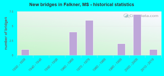
- New bridges - historical statistics
- 11930-1939
- 41960-1969
- 61970-1979
- 21990-1999
- 72000-2009
- 12010-2019


- Bridge Condition - Deck
- 9.1%Very good
- 54.5%Good
- 27.3%Satisfactory
- 9.1%Fair

- Bridge Condition - Superstructure
- 45.5%Very good
- 27.3%Good
- 9.1%Satisfactory
- 18.2%Fair

- Bridge Condition - Substructure
- 45.5%Very good
- 36.4%Good
- 9.1%Satisfactory
- 9.1%Fair

- Bridge Condition - Channel
- 23.8%Very good
- 42.9%Good
- 33.3%Satisfactory

- Bridge Condition - Culverts
- 20.0%Very good
- 70.0%Good
- 10.0%Satisfactory
Find on map >> Show street view
Structure Number: 31000150703202, Location: 5.3 MI N SR 4 (Lat: 34.800497, Lng: -88.929553), Route carried "on" structure: State highway 15, Year Built: 1973, Status: Open, Structure Length: 0.88m (2.89ft), Average Daily Traffic: 8,300 (year 2020), Truck Traffic: 22%, Average Future Daily Traffic: 8,800 (year 2040), Design Load: HS 20, Features Intersected: FOUR MILE BRANCH
Minimum Vertical Clearance: 30+ m (98+ ft), Kilometerpoint: 26.778, Lanes on structure: 2, Base Highway Network: Yes (Inventory Route: 1, Subroute: 2), Owner: State Highway Agency, Approaching Roadway Width: 13.4m (44.0ft), Skew: 3 degrees, Material/Design: Concrete, Design/Construction: Culvert, Number Of Spans In Main Unit: 2, Length of Maximum Span: 3.7m (12.1ft)
Condition: Channel: Satisfactory, Culverts: Satisfactory, Operating Rating: 68.4 metric tons, Method Used To Determine Operating Rating: Load Factor (LF), Inventory Rating: 40.9 metric tons, Method Used To Determine Inventory Rating: Load Factor (LF), Structural Evaluation: Equal to present minimum criteria, Waterway Adequacy: Equal to present desirable criteria, Approach Roadway Alignment: Equal to present desirable criteria, Designated Inspection Frequency: Every 24 months, Inspection Date: September 2021
Find on map >> Show street view
Structure Number: 31000150703226, Location: 7.7 MI N SR 4 (Lat: 34.834614, Lng: -88.938506), Route carried "on" structure: State highway 15, Year Built: 1973, Status: Open, Structure Length: 1.44m (4.72ft), Average Daily Traffic: 8,300 (year 2020), Truck Traffic: 22%, Average Future Daily Traffic: 8,800 (year 2040), Design Load: HS 20, Features Intersected: W PRONG MUDDY CREEK
Minimum Vertical Clearance: 30+ m (98+ ft), Kilometerpoint: 30.714, Lanes on structure: 2, Base Highway Network: Yes (Inventory Route: 1, Subroute: 2), Owner: State Highway Agency, Approaching Roadway Width: 13.4m (44.0ft), Skew: 3 degrees, Material/Design: Concrete, Design/Construction: Culvert, Number Of Spans In Main Unit: 2, Length of Maximum Span: 6.1m (20.0ft)
Condition: Channel: Satisfactory, Culverts: Good, Operating Rating: 62.2 metric tons, Method Used To Determine Operating Rating: Load Factor (LF), Inventory Rating: 37.3 metric tons, Method Used To Determine Inventory Rating: Load Factor (LF), Structural Evaluation: Better than present minimum criteria, Waterway Adequacy: Equal to present desirable criteria, Approach Roadway Alignment: Equal to present desirable criteria, Designated Inspection Frequency: Every 24 months, Inspection Date: September 2021
Find on map >> Show street view
Structure Number: 31000150703228, Location: 7.9 MI N SR 4 (Lat: 34.836844, Lng: -88.938497), Route carried "on" structure: State highway 15, Year Built: 1973, Status: Open, Structure Length: 0.75m (2.46ft), Average Daily Traffic: 8,300 (year 2020), Truck Traffic: 22%, Average Future Daily Traffic: 8,800 (year 2040), Design Load: HS 20, Features Intersected: MUDDY CREEK
Minimum Vertical Clearance: 30+ m (98+ ft), Kilometerpoint: 30.962, Lanes on structure: 2, Base Highway Network: Yes (Inventory Route: 1, Subroute: 2), Owner: State Highway Agency, Approaching Roadway Width: 13.4m (44.0ft), Material/Design: Concrete, Design/Construction: Culvert, Number Of Spans In Main Unit: 2, Length of Maximum Span: 3.7m (12.1ft)
Condition: Channel: Satisfactory, Culverts: Good, Operating Rating: 99.8 metric tons, Method Used To Determine Operating Rating: Load Factor (LF), Inventory Rating: 76.6 metric tons, Method Used To Determine Inventory Rating: Load Factor (LF), Structural Evaluation: Better than present minimum criteria, Waterway Adequacy: Equal to present desirable criteria, Approach Roadway Alignment: Equal to present desirable criteria, Designated Inspection Frequency: Every 24 months, Inspection Date: September 2021
Find on map >> Show street view
Structure Number: 31000150703229, Location: 8.0 MI N SR 4 (Lat: 34.839419, Lng: -88.938117), Route carried "on" structure: State highway 15, Year Built: 1970, Status: Open, Structure Length: 3.66m (12.01ft), Average Daily Traffic: 4,400 (year 2020), Truck Traffic: 13%, Average Future Daily Traffic: 4,700 (year 2040), Design Load: HS 20, Features Intersected: NORTH PRONG MUDDY CREEK
Minimum Vertical Clearance: 30+ m (98+ ft), Kilometerpoint: 31.252, Lanes on structure: 2, Base Highway Network: Yes (Inventory Route: 1, Subroute: 2), Owner: State Highway Agency, Approaching Roadway Width: 13.4m (44.0ft), Material/Design: Prestressed concrete, Design/Construction: Stringer/Multi-beam, Number Of Spans In Main Unit: 3, Length of Maximum Span: 12.2m (40.0ft), Curb-To-Curb Width: 11.7m (38.4ft), Out-to-Out Width: 12.7m (41.7ft)
Condition: Deck: Satisfactory, Superstructure: Very good, Substructure: Satisfactory, Channel: Good, Operating Rating: 61.6 metric tons, Method Used To Determine Operating Rating: Load Factor (LF), Inventory Rating: 36.1 metric tons, Method Used To Determine Inventory Rating: Load Factor (LF), Structural Evaluation: Equal to present minimum criteria, Deck Geometry: Somewhat better than minimum adequacy, Waterway Adequacy: Equal to present desirable criteria, Approach Roadway Alignment: Equal to present desirable criteria, Length Of Structure Improvement: 3.66m (12.01ft), Designated Inspection Frequency: Every 24 months, Inspection Date: September 2021, Bridge Improvement Cost: $34,000,000, Roadway Improvement Cost: $200,000,000, Total Project Cost: $271,000,000, Deck Structure Type: Concrete Cast-file-Place
Find on map >> Show street view
Structure Number: 3100015070325, Location: 10.1 MI N SR 4 (Lat: 34.865189, Lng: -88.920256), Route carried "on" structure: State highway 15, Year Built: 1938, Status: Open, Structure Length: 0.87m (2.85ft), Average Daily Traffic: 4,400 (year 2020), Truck Traffic: 13%, Average Future Daily Traffic: 4,700 (year 2040), Design Load: HS 20, Features Intersected: SHORT CREEK
Minimum Vertical Clearance: 30+ m (98+ ft), Kilometerpoint: 34.557, Lanes on structure: 2, Base Highway Network: Yes (Inventory Route: 1, Subroute: 2), Owner: State Highway Agency, Approaching Roadway Width: 13.4m (44.0ft), Skew: 3 degrees, Material/Design: Concrete, Design/Construction: Culvert, Number Of Spans In Main Unit: 2, Length of Maximum Span: 3.7m (12.1ft)
Condition: Channel: Good, Culverts: Good, Operating Rating: 48.1 metric tons, Method Used To Determine Operating Rating: Load Factor (LF), Inventory Rating: 28.8 metric tons, Method Used To Determine Inventory Rating: Load Factor (LF), Structural Evaluation: Better than present minimum criteria, Waterway Adequacy: Better than present minimum criteria, Approach Roadway Alignment: Equal to present desirable criteria, Designated Inspection Frequency: Every 24 months, Inspection Date: September 2021
Find on map >> Show street view
Structure Number: 31000150703256, Location: 10.9 MI N SR 4 (Lat: 34.873928, Lng: -88.916178), Route carried "on" structure: State highway 15, Year Built: 1973, Status: Open, Structure Length: 1.16m (3.81ft), Average Daily Traffic: 4,400 (year 2020), Truck Traffic: 13%, Average Future Daily Traffic: 4,700 (year 2040), Design Load: HS 20, Features Intersected: TURKEY CREEK
Minimum Vertical Clearance: 30+ m (98+ ft), Kilometerpoint: 35.597, Lanes on structure: 2, Base Highway Network: Yes (Inventory Route: 1, Subroute: 2), Owner: State Highway Agency, Approaching Roadway Width: 13.4m (44.0ft), Skew: 1 degrees, Material/Design: Concrete, Design/Construction: Culvert, Number Of Spans In Main Unit: 2, Length of Maximum Span: 5.5m (18.0ft)
Condition: Channel: Good, Culverts: Good, Operating Rating: 66.6 metric tons, Method Used To Determine Operating Rating: Load Factor (LF), Inventory Rating: 39.9 metric tons, Method Used To Determine Inventory Rating: Load Factor (LF), Structural Evaluation: Better than present minimum criteria, Waterway Adequacy: Equal to present minimum criteria, Approach Roadway Alignment: Equal to present desirable criteria, Designated Inspection Frequency: Every 24 months, Inspection Date: September 2021
Find on map >> Show street view
Structure Number: 31000150703266, Location: 11.7 MI N SR 4 (Lat: 34.886267, Lng: -88.911039), Route carried "on" structure: State highway 15, Year Built: 1973, Status: Open, Structure Length: 1.01m (3.31ft), Average Daily Traffic: 4,400 (year 2020), Truck Traffic: 13%, Average Future Daily Traffic: 4,700 (year 2040), Design Load: HS 20, Features Intersected: BLUFF CREEK
Minimum Vertical Clearance: 30+ m (98+ ft), Kilometerpoint: 37.045, Lanes on structure: 2, Base Highway Network: Yes (Inventory Route: 1, Subroute: 2), Owner: State Highway Agency, Approaching Roadway Width: 13.4m (44.0ft), Skew: 3 degrees, Material/Design: Concrete, Design/Construction: Culvert, Number Of Spans In Main Unit: 2, Length of Maximum Span: 4.3m (14.1ft)
Condition: Channel: Good, Culverts: Good, Operating Rating: 45.6 metric tons, Method Used To Determine Operating Rating: Load Factor (LF), Inventory Rating: 27.3 metric tons, Method Used To Determine Inventory Rating: Load Factor (LF), Structural Evaluation: Equal to present minimum criteria, Waterway Adequacy: Equal to present minimum criteria, Approach Roadway Alignment: Equal to present desirable criteria, Designated Inspection Frequency: Every 24 months, Inspection Date: September 2021
Find on map >> Show street view
Structure Number: SA7000000000014, Location: SEC 25 T 2S R 3E (Lat: 34.879211, Lng: -88.933150), Route carried "on" structure: County highway 158, Year Built: 2004, Status: Posted for load, Structure Length: 1.23m (4.04ft), Average Daily Traffic: 45 (year 2015), Average Future Daily Traffic: 68 (year 2035), Design Load: HS 20, Features Intersected: TURKEY CREEK, Facility Carried by Structure: CR 309
Minimum Vertical Clearance: 30+ m (98+ ft), Kilometerpoint: 3.057, Lanes on structure: 2, Owner: County Highway Agency, Approaching Roadway Width: 6.5m (21.3ft), Material/Design: Steel, Design/Construction: Stringer/Multi-beam, Number Of Spans In Main Unit: 1, Length of Maximum Span: 12.3m (40.4ft), Curb-To-Curb Width: 7.0m (23.0ft), Out-to-Out Width: 7.0m (23.0ft)
Condition: Deck: Good, Superstructure: Fair, Substructure: Good, Channel: Satisfactory, Operating Rating: 55.9 metric tons, Method Used To Determine Operating Rating: Load Factor (LF), Inventory Rating: 33.4 metric tons, Method Used To Determine Inventory Rating: Load Factor (LF), Structural Evaluation: Somewhat better than minimum adequacy, Deck Geometry: Somewhat better than minimum adequacy, Waterway Adequacy: Better than present minimum criteria, Approach Roadway Alignment: Equal to present desirable criteria, Designated Inspection Frequency: Every 24 months, Inspection Date: November 2020, Deck Structure Type: Concrete Cast-file-Place, Wearing Surface/Protective System: Wearing Surface: Gravel
Find on map >> Show street view
Structure Number: SA7000000000018, Location: SEC 20 T 2S R 4E B (Lat: 34.895278, Lng: -88.900556), Route carried "on" structure: County highway 2915, Year Built: 2003, Status: Open, Structure Length: 3.71m (12.17ft), Average Daily Traffic: 370 (year 2015), Truck Traffic: 8%, Average Future Daily Traffic: 555 (year 2035), Design Load: HS 20, Features Intersected: UNNAMED CREEK, Facility Carried by Structure: CR 204
Minimum Vertical Clearance: 30+ m (98+ ft), Kilometerpoint: 0.804, Lanes on structure: 2, Owner: County Highway Agency, Approaching Roadway Width: 6.7m (22.0ft), Material/Design: Prestressed concrete, Design/Construction: Stringer/Multi-beam, Number Of Spans In Main Unit: 3, Length of Maximum Span: 18.3m (60.0ft), Curb or Sidewalk Widths: Left: 0.5m (1.6ft), Right: 0.5m (1.6ft), Curb-To-Curb Width: 8.5m (27.9ft), Out-to-Out Width: 9.5m (31.2ft)
Condition: Deck: Good, Superstructure: Very good, Substructure: Very good, Channel: Very good, Operating Rating: 74.8 metric tons, Method Used To Determine Operating Rating: Load Factor (LF), Inventory Rating: 44.8 metric tons, Method Used To Determine Inventory Rating: Load Factor (LF), Structural Evaluation: Equal to present desirable criteria, Deck Geometry: Equal to present minimum criteria, Waterway Adequacy: Equal to present desirable criteria, Approach Roadway Alignment: Equal to present desirable criteria, Designated Inspection Frequency: Every 24 months, Inspection Date: October 2020, Deck Structure Type: Concrete Cast-file-Place, Wearing Surface/Protective System: Wearing Surface: Monolithic Concrete
Find on map >> Show street view
Structure Number: SA7000000000019, Location: SEC 20 T 2S R 4E B (Lat: 34.895000, Lng: -88.898611), Route carried "on" structure: County highway 2915, Year Built: 2003, Status: Open, Structure Length: 5.49m (18.01ft), Average Daily Traffic: 370 (year 2015), Truck Traffic: 8%, Average Future Daily Traffic: 555 (year 2035), Design Load: HS 20, Features Intersected: MUDDY CREEK, Facility Carried by Structure: CR 204
Minimum Vertical Clearance: 30+ m (98+ ft), Kilometerpoint: 0.965, Lanes on structure: 2, Owner: County Highway Agency, Approaching Roadway Width: 6.7m (22.0ft), Material/Design: Prestressed concrete, Design/Construction: Stringer/Multi-beam, Number Of Spans In Main Unit: 3, Length of Maximum Span: 30.5m (100.1ft), Curb or Sidewalk Widths: Left: 0.5m (1.6ft), Right: 0.5m (1.6ft), Curb-To-Curb Width: 8.5m (27.9ft), Out-to-Out Width: 9.5m (31.2ft)
Condition: Deck: Good, Superstructure: Very good, Substructure: Very good, Channel: Very good, Operating Rating: 76.1 metric tons, Method Used To Determine Operating Rating: Load Factor (LF), Inventory Rating: 39.6 metric tons, Method Used To Determine Inventory Rating: Load Factor (LF), Structural Evaluation: Equal to present desirable criteria, Deck Geometry: Equal to present minimum criteria, Waterway Adequacy: Equal to present desirable criteria, Approach Roadway Alignment: Equal to present desirable criteria, Designated Inspection Frequency: Every 24 months, Inspection Date: October 2020, Deck Structure Type: Concrete Cast-file-Place, Wearing Surface/Protective System: Wearing Surface: Monolithic Concrete
Find on map >> Show street view
Structure Number: SA700000000002, Location: SEC 20 T 2S R 4E B (Lat: 34.895328, Lng: -88.897881), Route carried "on" structure: County highway 2915, Year Built: 2003, Status: Open, Structure Length: 4.88m (16.01ft), Average Daily Traffic: 370 (year 2015), Truck Traffic: 8%, Average Future Daily Traffic: 555 (year 2035), Design Load: HS 20, Features Intersected: UNNAMED CREEK, Facility Carried by Structure: CR 204
Minimum Vertical Clearance: 30+ m (98+ ft), Kilometerpoint: 1.126, Lanes on structure: 2, Owner: County Highway Agency, Approaching Roadway Width: 6.7m (22.0ft), Material/Design: Prestressed concrete, Design/Construction: Stringer/Multi-beam, Number Of Spans In Main Unit: 4, Length of Maximum Span: 12.2m (40.0ft), Curb or Sidewalk Widths: Left: 0.5m (1.6ft), Right: 0.5m (1.6ft), Curb-To-Curb Width: 8.5m (27.9ft), Out-to-Out Width: 9.5m (31.2ft)
Condition: Deck: Good, Superstructure: Very good, Substructure: Very good, Channel: Very good, Operating Rating: 76.1 metric tons, Method Used To Determine Operating Rating: Load Factor (LF), Inventory Rating: 39.6 metric tons, Method Used To Determine Inventory Rating: Load Factor (LF), Structural Evaluation: Equal to present desirable criteria, Deck Geometry: Equal to present minimum criteria, Waterway Adequacy: Equal to present desirable criteria, Approach Roadway Alignment: Equal to present desirable criteria, Designated Inspection Frequency: Every 24 months, Inspection Date: October 2020, Deck Structure Type: Concrete Cast-file-Place, Wearing Surface/Protective System: Wearing Surface: Monolithic Concrete
Find on map >> Show street view
Structure Number: SA7000000000028, Location: SEC 2 T 3S R 3E (Lat: 34.856389, Lng: -88.964722), Route carried "on" structure: County highway 155, Year Built: 2006, Status: Open, Structure Length: 0.95m (3.12ft), Average Daily Traffic: 105 (year 2015), Truck Traffic: 8%, Average Future Daily Traffic: 158 (year 2035), Design Load: HS 20, Features Intersected: MUDDY BRANCH, Facility Carried by Structure: CR 343
Minimum Vertical Clearance: 30+ m (98+ ft), Kilometerpoint: 0.965, Lanes on structure: 2, Owner: County Highway Agency, Approaching Roadway Width: 8.5m (27.9ft), Skew: 4 degrees, Material/Design: Concrete, Design/Construction: Culvert, Number Of Spans In Main Unit: 2, Length of Maximum Span: 3.1m (10.2ft)
Condition: Channel: Satisfactory, Culverts: Very good, Operating Rating: 80.0 metric tons, Method Used To Determine Operating Rating: Load Factor (LF), Inventory Rating: 48.0 metric tons, Method Used To Determine Inventory Rating: Load Factor (LF), Structural Evaluation: Equal to present desirable criteria, Waterway Adequacy: Equal to present desirable criteria, Approach Roadway Alignment: Equal to present desirable criteria, Designated Inspection Frequency: Every 24 months, Inspection Date: October 2020
Find on map >> Show street view
Structure Number: SA7000000000029, Location: SEC 12 T 3S R 3E B (Lat: 34.840556, Lng: -88.929833), Route carried "on" structure: County highway 970, Year Built: 1962, Status: Posted for load, Structure Length: 2.38m (7.81ft), Average Daily Traffic: 620 (year 2015), Truck Traffic: 8%, Average Future Daily Traffic: 930 (year 2035), Design Load: HS 20, Features Intersected: UNNAMED CREEK, Facility Carried by Structure: CR 200
Minimum Vertical Clearance: 30+ m (98+ ft), Kilometerpoint: 28.324, Lanes on structure: 2, Owner: County Highway Agency, Approaching Roadway Width: 6.7m (22.0ft), Material/Design: Concrete, Design/Construction: Stringer/Multi-beam, Number Of Spans In Main Unit: 1, Number Of Approach Spans: 2, Length of Maximum Span: 12.2m (40.0ft), Curb or Sidewalk Widths: Left: 0.4m (1.3ft), Right: 0.4m (1.3ft), Curb-To-Curb Width: 6.7m (22.0ft), Out-to-Out Width: 7.5m (24.6ft)
Condition: Deck: Satisfactory, Superstructure: Good, Substructure: Good, Channel: Good, Operating Rating: 32.2 metric tons, Method Used To Determine Operating Rating: Load Factor (LF), Inventory Rating: 19.3 metric tons, Method Used To Determine Inventory Rating: Load Factor (LF), Structural Evaluation: Somewhat better than minimum adequacy, Deck Geometry: Meets minimum limits, Waterway Adequacy: Equal to present desirable criteria, Approach Roadway Alignment: Equal to present desirable criteria, Bridge Posting: Required (Relationship of Operating Rating to Maximum Legal Load: 10.0 - 19.9% below), Length Of Structure Improvement: 2.83m (9.28ft), Designated Inspection Frequency: Every 12 months, Inspection Date: September 2021, Bridge Improvement Cost: $169,000, Roadway Improvement Cost: $17,000, Total Project Cost: $208,000 ( Estimate for 2016), Deck Structure Type: Concrete Cast-file-Place
Find on map >> Show street view
Structure Number: SA700000000003, Location: SEC 12 T 3S R 3E B (Lat: 34.841111, Lng: -88.930833), Route carried "on" structure: County highway 970, Year Built: 1962, Status: Posted for load, Structure Length: 3.66m (12.01ft), Average Daily Traffic: 620 (year 2015), Truck Traffic: 8%, Average Future Daily Traffic: 930 (year 2035), Design Load: H 15, Features Intersected: UNNAMED CREEK, Facility Carried by Structure: CR 200
Minimum Vertical Clearance: 30+ m (98+ ft), Kilometerpoint: 28.485, Lanes on structure: 2, Owner: County Highway Agency, Approaching Roadway Width: 6.7m (22.0ft), Material/Design: Concrete, Design/Construction: Stringer/Multi-beam, Number Of Spans In Main Unit: 3, Length of Maximum Span: 12.2m (40.0ft), Curb or Sidewalk Widths: Left: 0.4m (1.3ft), Right: 0.4m (1.3ft), Curb-To-Curb Width: 6.7m (22.0ft), Out-to-Out Width: 7.5m (24.6ft)
Condition: Deck: Fair, Superstructure: Satisfactory, Substructure: Fair, Channel: Good, Operating Rating: 32.7 metric tons, Method Used To Determine Operating Rating: Load Factor (LF), Inventory Rating: 19.6 metric tons, Method Used To Determine Inventory Rating: Load Factor (LF), Structural Evaluation: Somewhat better than minimum adequacy, Deck Geometry: Meets minimum limits, Waterway Adequacy: Equal to present desirable criteria, Approach Roadway Alignment: Equal to present desirable criteria, Bridge Posting: Required (Relationship of Operating Rating to Maximum Legal Load: 0.1 - 9.9% below), Length Of Structure Improvement: 3.66m (12.01ft), Designated Inspection Frequency: Every 24 months, Inspection Date: November 2020, Bridge Improvement Cost: $218,000, Roadway Improvement Cost: $22,000, Total Project Cost: $269,000 ( Estimate for 2016), Deck Structure Type: Concrete Cast-file-Place, Wearing Surface/Protective System: Wearing Surface: Monolithic Concrete
Find on map >> Show street view
Structure Number: SA7000000000031, Location: SEC 16 T 3S R 3E (Lat: 34.828639, Lng: -88.983611), Route carried "on" structure: County highway 208, Year Built: 1995, Status: Open, Structure Length: 0.79m (2.59ft), Average Daily Traffic: 120 (year 2015), Truck Traffic: 8%, Average Future Daily Traffic: 180 (year 2035), Design Load: HS 20, Features Intersected: UNNAMED CREEK, Facility Carried by Structure: FALKNER-ASHLAND RD
Minimum Vertical Clearance: 30+ m (98+ ft), Kilometerpoint: 3.379, Lanes on structure: 2, Owner: County Highway Agency, Approaching Roadway Width: 9.1m (29.9ft), Skew: 4 degrees, Material/Design: Concrete, Design/Construction: Culvert, Number Of Spans In Main Unit: 2, Length of Maximum Span: 4.0m (13.1ft)
Condition: Channel: Satisfactory, Culverts: Very good, Operating Rating: 90.2 metric tons, Method Used To Determine Operating Rating: Load Factor (LF), Inventory Rating: 53.9 metric tons, Method Used To Determine Inventory Rating: Load Factor (LF), Structural Evaluation: Equal to present desirable criteria, Waterway Adequacy: Equal to present desirable criteria, Approach Roadway Alignment: Equal to present desirable criteria, Designated Inspection Frequency: Every 24 months, Inspection Date: October 2020
Find on map >> Show street view
Structure Number: SA7000000000033, Location: SEC 7 T 3S R 4E B (Lat: 34.839722, Lng: -88.927444), Route carried "on" structure: County highway 970, Year Built: 1962, Status: Posted for load, Structure Length: 2.38m (7.81ft), Average Daily Traffic: 620 (year 2015), Truck Traffic: 8%, Average Future Daily Traffic: 930 (year 2035), Design Load: HS 20, Features Intersected: BELL CREEK, Facility Carried by Structure: CR 200
Minimum Vertical Clearance: 30+ m (98+ ft), Kilometerpoint: 28.163, Lanes on structure: 2, Owner: County Highway Agency, Approaching Roadway Width: 6.7m (22.0ft), Material/Design: Concrete, Design/Construction: Stringer/Multi-beam, Number Of Spans In Main Unit: 1, Number Of Approach Spans: 2, Length of Maximum Span: 12.2m (40.0ft), Curb or Sidewalk Widths: Left: 0.4m (1.3ft), Right: 0.4m (1.3ft), Curb-To-Curb Width: 6.7m (22.0ft), Out-to-Out Width: 7.5m (24.6ft)
Condition: Deck: Satisfactory, Superstructure: Good, Substructure: Good, Channel: Very good, Operating Rating: 32.2 metric tons, Method Used To Determine Operating Rating: Load Factor (LF), Inventory Rating: 19.3 metric tons, Method Used To Determine Inventory Rating: Load Factor (LF), Structural Evaluation: Somewhat better than minimum adequacy, Deck Geometry: Meets minimum limits, Waterway Adequacy: Equal to present desirable criteria, Approach Roadway Alignment: Equal to present desirable criteria, Bridge Posting: Required (Relationship of Operating Rating to Maximum Legal Load: 10.0 - 19.9% below), Length Of Structure Improvement: 2.83m (9.28ft), Designated Inspection Frequency: Every 12 months, Inspection Date: September 2021, Bridge Improvement Cost: $169,000, Roadway Improvement Cost: $17,000, Total Project Cost: $208,000 ( Estimate for 2016), Deck Structure Type: Concrete Cast-file-Place, Wearing Surface/Protective System: Wearing Surface: Monolithic Concrete
Find on map >> Show street view
Structure Number: SA7000000000035, Location: SEC 16 T 3S R 4E B (Lat: 34.816222, Lng: -88.878444), Route carried "on" structure: County highway 89, Year Built: 2004, Status: Posted for load, Structure Length: 1.10m (3.61ft), Average Daily Traffic: 40 (year 2015), Average Future Daily Traffic: 60 (year 2035), Design Load: HS 15, Features Intersected: WALNUT CREEK, Facility Carried by Structure: CR 564
Minimum Vertical Clearance: 30+ m (98+ ft), Kilometerpoint: 10.782, Lanes on structure: 2, Owner: County Highway Agency, Approaching Roadway Width: 5.5m (18.0ft), Material/Design: Steel, Design/Construction: Stringer/Multi-beam, Number Of Spans In Main Unit: 1, Length of Maximum Span: 11.0m (36.1ft), Curb or Sidewalk Widths: Left: 0.1m (0.3ft), Right: 0.1m (0.3ft), Curb-To-Curb Width: 5.9m (19.4ft), Out-to-Out Width: 6.1m (20.0ft)
Condition: Deck: Good, Superstructure: Fair, Substructure: Good, Channel: Good, Operating Rating: 24.5 metric tons, Method Used To Determine Operating Rating: Load Factor (LF), Inventory Rating: 14.7 metric tons, Method Used To Determine Inventory Rating: Load Factor (LF), Structural Evaluation: Meets minimum limits, Deck Geometry: Meets minimum limits, Waterway Adequacy: Equal to present desirable criteria, Approach Roadway Alignment: Better than present minimum criteria, Bridge Posting: Required (Relationship of Operating Rating to Maximum Legal Load: 30.0 - 39.9% below), Designated Inspection Frequency: Every 24 months, Inspection Date: October 2020, Deck Structure Type: Concrete Cast-file-Place, Wearing Surface/Protective System: Wearing Surface: Monolithic Concrete
Find on map >> Show street view
Structure Number: SA7000000000036, Location: SEC 18 T 3S R 4E (Lat: 34.820378, Lng: -88.921281), Route carried "on" structure: County highway 87, Year Built: 1999, Status: Open, Structure Length: 3.76m (12.34ft), Average Daily Traffic: 50 (year 2015), Truck Traffic: 10%, Average Future Daily Traffic: 75 (year 2035), Design Load: HS 20, Features Intersected: BELL CREEK, Facility Carried by Structure: CR 506
Minimum Vertical Clearance: 30+ m (98+ ft), Kilometerpoint: 0.965, Lanes on structure: 2, Owner: County Highway Agency, Approaching Roadway Width: 8.5m (27.9ft), Skew: 3 degrees, Material/Design: Concrete, Design/Construction: Channel Beam, Number Of Spans In Main Unit: 4, Length of Maximum Span: 9.4m (30.8ft), Curb or Sidewalk Widths: Left: 0.5m (1.6ft), Right: 0.5m (1.6ft), Curb-To-Curb Width: 8.5m (27.9ft), Out-to-Out Width: 9.5m (31.2ft)
Condition: Deck: Very good, Superstructure: Good, Substructure: Very good, Channel: Good, Operating Rating: 63.1 metric tons, Method Used To Determine Operating Rating: Load Factor (LF), Inventory Rating: 37.9 metric tons, Method Used To Determine Inventory Rating: Load Factor (LF), Structural Evaluation: Better than present minimum criteria, Deck Geometry: Better than present minimum criteria, Waterway Adequacy: Equal to present desirable criteria, Approach Roadway Alignment: Equal to present desirable criteria, Designated Inspection Frequency: Every 24 months, Inspection Date: October 2020, Deck Structure Type: Concrete Precast Panels, Wearing Surface/Protective System: Wearing Surface: Monolithic Concrete
Find on map >> Show street view
Structure Number: SA7000000000039, Location: SEC 30 T 3S R 4E B (Lat: 34.796833, Lng: -88.924444), Route carried "on" structure: County highway 93, Year Built: 1968, Status: Open, Structure Length: 0.79m (2.59ft), Average Daily Traffic: 200 (year 2015), Truck Traffic: 8%, Average Future Daily Traffic: 300 (year 2035), Design Load: HS 20, Features Intersected: BELL CREEK, Facility Carried by Structure: CR 502
Minimum Vertical Clearance: 30+ m (98+ ft), Kilometerpoint: 0.482, Lanes on structure: 2, Owner: County Highway Agency, Approaching Roadway Width: 9.1m (29.9ft), Material/Design: Concrete, Design/Construction: Culvert, Number Of Spans In Main Unit: 2, Length of Maximum Span: 3.7m (12.1ft)
Condition: Channel: Satisfactory, Culverts: Good, Operating Rating: 58.5 metric tons, Method Used To Determine Operating Rating: Load Factor (LF), Inventory Rating: 35.0 metric tons, Method Used To Determine Inventory Rating: Load Factor (LF), Structural Evaluation: Better than present minimum criteria, Waterway Adequacy: Equal to present desirable criteria, Approach Roadway Alignment: Equal to present desirable criteria, Designated Inspection Frequency: Every 24 months, Inspection Date: October 2020
Find on map >> Show street view
Structure Number: SA7000000000111, Location: SEC 16 T 3S R 3E (Lat: 34.824908, Lng: -88.982972), Route carried "on" structure: County highway 210, Year Built: 2001, Status: Open, Structure Length: 0.68m (2.23ft), Average Daily Traffic: 53 (year 2021), Average Future Daily Traffic: 75 (year 2040), Design Load: HS 20, Features Intersected: MUDDY CREEK PRONG, Facility Carried by Structure: CR 414
Minimum Vertical Clearance: 30+ m (98+ ft), Kilometerpoint: 1.609, Lanes on structure: 2, Owner: County Highway Agency, Approaching Roadway Width: 8.5m (27.9ft), Material/Design: Concrete, Design/Construction: Culvert, Number Of Spans In Main Unit: 2, Length of Maximum Span: 3.0m (9.8ft)
Condition: Channel: Good, Culverts: Good, Operating Rating: 87.9 metric tons, Method Used To Determine Operating Rating: Load Factor (LF), Inventory Rating: 52.6 metric tons, Method Used To Determine Inventory Rating: Load Factor (LF), Structural Evaluation: Better than present minimum criteria, Waterway Adequacy: Equal to present desirable criteria, Approach Roadway Alignment: Equal to present desirable criteria, Designated Inspection Frequency: Every 24 months, Inspection Date: October 2021
Find on map >> Show street view
Structure Number: SA700000000A11, Location: SEC 31 T 2S R 4E (Lat: 34.863111, Lng: -88.913667), Route carried "on" structure: County highway , Year Built: 2015, Status: Open, Structure Length: 4.88m (16.01ft), Average Daily Traffic: 105 (year 2020), Truck Traffic: 8%, Average Future Daily Traffic: 158 (year 2040), Design Load: HS 20+Mod, Features Intersected: MUDDY CREEK, Facility Carried by Structure: CR 238
Minimum Vertical Clearance: 30+ m (98+ ft), Kilometerpoint: 1.770, Lanes on structure: 2, Owner: County Highway Agency, Approaching Roadway Width: 7.9m (25.9ft), Material/Design: Prestressed concrete, Design/Construction: Stringer/Multi-beam, Number Of Spans In Main Unit: 3, Length of Maximum Span: 24.4m (80.1ft), Curb or Sidewalk Widths: Left: 0.5m (1.6ft), Right: 0.5m (1.6ft), Curb-To-Curb Width: 8.5m (27.9ft), Out-to-Out Width: 9.5m (31.2ft)
Condition: Deck: Good, Superstructure: Very good, Substructure: Very good, Channel: Very good, Operating Rating: 58.2 metric tons, Method Used To Determine Operating Rating: Load Factor (LF), Inventory Rating: 28.1 metric tons, Method Used To Determine Inventory Rating: Load Factor (LF), Structural Evaluation: Better than present minimum criteria, Deck Geometry: Equal to present minimum criteria, Waterway Adequacy: Equal to present desirable criteria, Approach Roadway Alignment: Equal to present minimum criteria, Designated Inspection Frequency: Every 24 months, Inspection Date: October 2021, Deck Structure Type: Concrete Cast-file-Place, Wearing Surface/Protective System: Wearing Surface: Monolithic Concrete