Bridge Statistics for Flomaton, Alabama (AL)
Condition, Traffic, Stress, Structural Evaluation, Project Costs
- National Bridge Inventory (NBI) Statistics
- 15Number of bridges
- 354ft / 108mTotal length
- $43,083,000Total costs
- 46,195Total average daily traffic
- 3,102Total average daily truck traffic
- National Bridge Inventory (NBI) Registered Bridges for Flomaton
- No street view available for this location
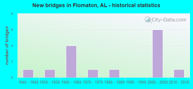
- New bridges - historical statistics
- 11940-1949
- 11950-1959
- 41960-1969
- 11970-1979
- 11980-1989
- 62000-2009
- 12010-2019


- Bridge Condition - Deck
- 8.3%Excellent
- 16.7%Very good
- 8.3%Good
- 33.3%Satisfactory
- 33.3%Fair

- Bridge Condition - Superstructure
- 8.3%Excellent
- 16.7%Very good
- 8.3%Good
- 33.3%Satisfactory
- 33.3%Fair

- Bridge Condition - Substructure
- 8.3%Excellent
- 16.7%Very good
- 16.7%Good
- 33.3%Satisfactory
- 25.0%Fair

- Bridge Condition - Channel
- 9.1%Very good
- 36.4%Good
- 27.3%Satisfactory
- 27.3%Fair

- Bridge Condition - Culverts
- 50.0%Satisfactory
- 50.0%Fair
Find on map >> Show street view
Structure Number: 3399, Location: 2.2 MI N US 29 (Lat: 31.019558, Lng: -87.236489), Route carried "on" structure: US 31, Year Built: 1949, Status: Open, Structure Length: 4.33m (14.21ft), Average Daily Traffic: 3,683 (year 2019), Truck Traffic: 6%, Average Future Daily Traffic: 5,525 (year 2039), Design Load: H 20, Features Intersected: AL RR
Minimum Vertical Clearance: 30+ m (98+ ft), Kilometerpoint: 92.624, Lanes on structure: 2, Owner: State Highway Agency, Approaching Roadway Width: 7.4m (24.3ft), Skew: 3 degrees, Material/Design: Concrete, Design/Construction: Tee Beam, Number Of Spans In Main Unit: 5, Length of Maximum Span: 9.1m (29.9ft), Curb-To-Curb Width: 8.4m (27.6ft), Out-to-Out Width: 10.1m (33.1ft)
Condition: Deck: Fair, Superstructure: Fair, Substructure: Fair, Operating Rating: 39.9 metric tons, Method Used To Determine Operating Rating: Load Factor (LF), Inventory Rating: 23.9 metric tons, Method Used To Determine Inventory Rating: Load Factor (LF), Structural Evaluation: Somewhat better than minimum adequacy, Deck Geometry: High priority of corrective action, Underclear: Somewhat better than minimum adequacy, Approach Roadway Alignment: Better than present minimum criteria, Length Of Structure Improvement: 5.31m (17.42ft), Designated Inspection Frequency: Every 24 months, Inspection Date: March 2021, Bridge Improvement Cost: $1,201,000, Roadway Improvement Cost: $120,000, Total Project Cost: $1,321,000 ( Estimate for 2022), Deck Structure Type: Concrete Cast-file-Place
Find on map >> Show street view
Structure Number: 5884, Location: 1MI E FLOMATON (Lat: 31.003847, Lng: -87.224694), Route carried "on" structure: ServiceCounty highway 25, Year Built: 1957, Status: Posted for load, Structure Length: 0.98m (3.22ft), Average Daily Traffic: 1,250 (year 1988), Truck Traffic: 15%, Average Future Daily Traffic: 1,950 (year 2034), Design Load: H 10, Features Intersected: RAILROAD BRANCH, Facility Carried by Structure: COUNTY HIGHWAY
Minimum Vertical Clearance: 30+ m (98+ ft), Kilometerpoint: 0.010, Lanes on structure: 2, Owner: County Highway Agency, Approaching Roadway Width: 7.9m (25.9ft), Material/Design: Wood or Timber, Design/Construction: Stringer/Multi-beam, Number Of Spans In Main Unit: 2, Length of Maximum Span: 4.9m (16.1ft), Curb or Sidewalk Widths: Left: 0.2m (0.7ft), Right: 0.2m (0.7ft), Curb-To-Curb Width: 6.1m (20.0ft), Out-to-Out Width: 6.5m (21.3ft)
Condition: Deck: Fair, Superstructure: Fair, Substructure: Fair, Channel: Satisfactory, Operating Rating: 15.8 metric tons, Method Used To Determine Operating Rating: Allowable Stress (AS), Inventory Rating: 10.9 metric tons, Method Used To Determine Inventory Rating: Allowable Stress (AS), Structural Evaluation: High priority of replacement, Deck Geometry: High priority of replacement, Waterway Adequacy: Better than present minimum criteria, Approach Roadway Alignment: Better than present minimum criteria, Bridge Posting: Required (Relationship of Operating Rating to Maximum Legal Load: > 39.9% below), Length Of Structure Improvement: 1.65m (5.41ft), Designated Inspection Frequency: Every 24 months, Other Special Inspection Frequency: Every 12 months, Inspection Date: Febuary 2021, Other Special Inspection Date: Febuary 2022, Bridge Improvement Cost: $238,000, Roadway Improvement Cost: $24,000, Total Project Cost: $262,000 ( Estimate for 2022), Deck Structure Type: Concrete Cast-file-Place
Find on map >> Show street view
Structure Number: 793, Location: 3 MI WNW POLLARD (Lat: 31.044478, Lng: -87.219242), Route carried "on" structure: ServiceCounty highway 6, Year Built: 1963, Status: Posted for load, Structure Length: 11.64m (38.19ft), Average Daily Traffic: 470 (year 1988), Truck Traffic: 10%, Average Future Daily Traffic: 682 (year 2034), Design Load: H 15, Features Intersected: LITTLE ESCAMBIA CREEK, Facility Carried by Structure: COUNTY HIGHWAY
Minimum Vertical Clearance: 30+ m (98+ ft), Kilometerpoint: 0.010, Lanes on structure: 2, Owner: County Highway Agency, Approaching Roadway Width: 9.1m (29.9ft), Material/Design: Steel, Design/Construction: Stringer/Multi-beam, Number Of Spans In Main Unit: 2, Number Of Approach Spans: 6, Length of Maximum Span: 16.8m (55.1ft), Curb or Sidewalk Widths: Left: 0.2m (0.7ft), Right: 0.2m (0.7ft), Curb-To-Curb Width: 6.7m (22.0ft), Out-to-Out Width: 7.1m (23.3ft)
Condition: Deck: Fair, Superstructure: Satisfactory, Substructure: Satisfactory, Channel: Satisfactory, Operating Rating: 35.3 metric tons, Method Used To Determine Operating Rating: Allowable Stress (AS), Inventory Rating: 19.4 metric tons, Method Used To Determine Inventory Rating: Allowable Stress (AS), Structural Evaluation: Somewhat better than minimum adequacy, Deck Geometry: Meets minimum limits, Waterway Adequacy: Superior to present desirable criteria, Approach Roadway Alignment: Equal to present desirable criteria, Bridge Posting: Required (Relationship of Operating Rating to Maximum Legal Load: 0.1 - 9.9% below), Length Of Structure Improvement: 12.51m (41.04ft), Designated Inspection Frequency: Every 24 months, Other Special Inspection Frequency: Every 12 months, Inspection Date: January 2021, Other Special Inspection Date: January 2022, Bridge Improvement Cost: $1,972,000, Roadway Improvement Cost: $197,000, Total Project Cost: $2,169,000 ( Estimate for 2022), Deck Structure Type: Concrete Cast-file-Place
Find on map >> Show street view
Structure Number: 8763, Location: 1 MI S OSAKA (Lat: 31.045347, Lng: -87.229225), Route carried "on" structure: ServiceCounty highway 33, Year Built: 1965, Status: Posted for load, Structure Length: 1.43m (4.69ft), Average Daily Traffic: 390 (year 1988), Truck Traffic: 5%, Average Future Daily Traffic: 566 (year 2034), Design Load: H 10, Features Intersected: INDIAN BRANCH, Facility Carried by Structure: COUNTY HIGHWAY
Minimum Vertical Clearance: 30+ m (98+ ft), Kilometerpoint: 0.010, Lanes on structure: 2, Owner: County Highway Agency, Approaching Roadway Width: 8.5m (27.9ft), Material/Design: Wood or Timber, Design/Construction: Stringer/Multi-beam, Number Of Spans In Main Unit: 3, Length of Maximum Span: 4.9m (16.1ft), Curb or Sidewalk Widths: Left: 0.2m (0.7ft), Right: 0.2m (0.7ft), Curb-To-Curb Width: 6.7m (22.0ft), Out-to-Out Width: 7.1m (23.3ft)
Condition: Deck: Satisfactory, Superstructure: Satisfactory, Substructure: Satisfactory, Channel: Good, Operating Rating: 20.5 metric tons, Method Used To Determine Operating Rating: Allowable Stress (AS), Inventory Rating: 14.6 metric tons, Method Used To Determine Inventory Rating: Allowable Stress (AS), Structural Evaluation: Meets minimum limits, Deck Geometry: Meets minimum limits, Waterway Adequacy: Equal to present desirable criteria, Approach Roadway Alignment: Equal to present minimum criteria, Bridge Posting: Required (Relationship of Operating Rating to Maximum Legal Load: > 39.9% below), Length Of Structure Improvement: 2.11m (6.92ft), Designated Inspection Frequency: Every 24 months, Other Special Inspection Frequency: Every 12 months, Inspection Date: January 2021, Other Special Inspection Date: January 2022, Bridge Improvement Cost: $332,000, Roadway Improvement Cost: $33,000, Total Project Cost: $365,000 ( Estimate for 2022), Deck Structure Type: Concrete Cast-file-Place, Wearing Surface/Protective System: Wearing Surface: Bituminous
Find on map >> Show street view
Structure Number: 9782, Location: 0.1 MI N AL/FL LINE (Lat: 30.998869, Lng: -87.261086), Route carried "on" structure: US 29, Year Built: 1968, Status: Open, Structure Length: 16.03m (52.59ft), Average Daily Traffic: 11,748 (year 2019), Truck Traffic: 7%, Average Future Daily Traffic: 17,622 (year 2039), Design Load: HS 20, Features Intersected: CSX RR * RINGOLD ST, Facility Carried by Structure: SR 113
Minimum Vertical Clearance: 30+ m (98+ ft), Kilometerpoint: 0.126, Lanes on structure: 4, Lanes under structure: 2, Base Highway Network: Yes, Owner: State Highway Agency, Approaching Roadway Width: 24.4m (80.1ft), Skew: 22 degrees, Material/Design: Steel, Design/Construction: Stringer/Multi-beam, Number Of Spans In Main Unit: 9, Length of Maximum Span: 23.8m (78.1ft), Curb or Sidewalk Widths: Left: 1.9m (6.2ft), Right: 1.9m (6.2ft), Curb-To-Curb Width: 18.3m (60.0ft), Out-to-Out Width: 22.0m (72.2ft)
Condition: Deck: Fair, Superstructure: Fair, Substructure: Satisfactory, Operating Rating: 76.3 metric tons, Method Used To Determine Operating Rating: Load Factor (LF), Inventory Rating: 45.6 metric tons, Method Used To Determine Inventory Rating: Load Factor (LF), Structural Evaluation: Somewhat better than minimum adequacy, Deck Geometry: Somewhat better than minimum adequacy, Underclear: Meets minimum limits, Approach Roadway Alignment: Equal to present minimum criteria, Length Of Structure Improvement: 16.78m (55.05ft), Designated Inspection Frequency: Every 24 months, Inspection Date: March 2021, Bridge Improvement Cost: $8,286,000, Roadway Improvement Cost: $829,000, Total Project Cost: $9,115,000 ( Estimate for 2022), Deck Structure Type: Concrete Cast-file-Place
Find on map >> Show street view
Structure Number: 11157, Location: 2MI NW OSAKA (Lat: 31.085206, Lng: -87.253622), Route carried "on" structure: ServiceCounty highway 278, Year Built: 1974, Status: Posted for load, Structure Length: 3.47m (11.38ft), Average Daily Traffic: 110 (year 1988), Truck Traffic: 5%, Average Future Daily Traffic: 160 (year 2034), Design Load: H 15, Features Intersected: HALL CREEK, Facility Carried by Structure: COUNTY ROAD
Minimum Vertical Clearance: 30+ m (98+ ft), Kilometerpoint: 0.010, Lanes on structure: 2, Owner: County Highway Agency, Approaching Roadway Width: 7.9m (25.9ft), Material/Design: Concrete, Design/Construction: Channel Beam, Number Of Spans In Main Unit: 7, Length of Maximum Span: 5.8m (19.0ft), Curb or Sidewalk Widths: Left: 0.2m (0.7ft), Right: 0.2m (0.7ft), Curb-To-Curb Width: 7.3m (24.0ft), Out-to-Out Width: 7.6m (24.9ft)
Condition: Deck: Satisfactory, Superstructure: Fair, Substructure: Fair, Channel: Fair, Operating Rating: 38.7 metric tons, Method Used To Determine Operating Rating: Load Factor (LF), Inventory Rating: 23.2 metric tons, Method Used To Determine Inventory Rating: Load Factor (LF), Structural Evaluation: Somewhat better than minimum adequacy, Deck Geometry: Somewhat better than minimum adequacy, Waterway Adequacy: Better than present minimum criteria, Approach Roadway Alignment: Better than present minimum criteria, Bridge Posting: Required (Relationship of Operating Rating to Maximum Legal Load: 0.1 - 9.9% below), Length Of Structure Improvement: 4.38m (14.37ft), Designated Inspection Frequency: Every 24 months, Other Special Inspection Frequency: Every 12 months, Inspection Date: January 2021, Other Special Inspection Date: January 2022, Bridge Improvement Cost: $750,000, Roadway Improvement Cost: $75,000, Total Project Cost: $825,000 ( Estimate for 2022), Deck Structure Type: Concrete Precast Panels, Wearing Surface/Protective System: Wearing Surface: Bituminous
Find on map >> Show street view
Structure Number: 13568, Location: 1.9 MI S US 29 (Lat: 31.015736, Lng: -87.292542), Route carried "on" structure: US 31, Year Built: 1985, Status: Open, Structure Length: 0.98m (3.22ft), Average Daily Traffic: 3,947 (year 2020), Truck Traffic: 5%, Average Future Daily Traffic: 5,920 (year 2040), Design Load: HS 20, Features Intersected: THOMPSON BRANCH
Minimum Vertical Clearance: 30+ m (98+ ft), Kilometerpoint: 86.156, Lanes on structure: 2, Owner: State Highway Agency, Approaching Roadway Width: 8.5m (27.9ft), Material/Design: Concrete, Design/Construction: Culvert, Number Of Spans In Main Unit: 3, Length of Maximum Span: 3.0m (9.8ft)
Condition: Channel: Good, Culverts: Fair, Operating Rating: 77.8 metric tons, Method Used To Determine Operating Rating: Load Factor (LF), Inventory Rating: 46.7 metric tons, Method Used To Determine Inventory Rating: Load Factor (LF), Structural Evaluation: Somewhat better than minimum adequacy, Waterway Adequacy: Equal to present minimum criteria, Approach Roadway Alignment: Better than present minimum criteria, Length Of Structure Improvement: 1.64m (5.38ft), Designated Inspection Frequency: Every 24 months, Inspection Date: January 2022, Bridge Improvement Cost: $418,000, Roadway Improvement Cost: $42,000, Total Project Cost: $460,000 ( Estimate for 2022)
Find on map >> Show street view
Structure Number: 16569, Location: 2.2 MI N US 29 (Lat: 31.019411, Lng: -87.236464), Route carried "on" structure: US 31, Year Built: 2009, Status: Open, Structure Length: 6.03m (19.78ft), Average Daily Traffic: 3,683 (year 2019), Truck Traffic: 6%, Average Future Daily Traffic: 5,525 (year 2039), Design Load: HS 20, Features Intersected: ALA RR
Minimum Vertical Clearance: 30+ m (98+ ft), Kilometerpoint: 92.623, Lanes on structure: 2, Owner: State Highway Agency, Approaching Roadway Width: 10.7m (35.1ft), Skew: 13 degrees, Material/Design: Prestressed concrete, Design/Construction: Stringer/Multi-beam, Number Of Spans In Main Unit: 3, Length of Maximum Span: 21.2m (69.6ft), Curb-To-Curb Width: 12.2m (40.0ft), Out-to-Out Width: 13.2m (43.3ft)
Condition: Deck: Very good, Superstructure: Very good, Substructure: Good, Operating Rating: 79.3 metric tons, Method Used To Determine Operating Rating: Load Factor (LF), Inventory Rating: 47.4 metric tons, Method Used To Determine Inventory Rating: Load Factor (LF), Structural Evaluation: Better than present minimum criteria, Deck Geometry: Better than present minimum criteria, Underclear: Superior to present desirable criteria, Approach Roadway Alignment: Equal to present desirable criteria, Length Of Structure Improvement: 7.07m (23.20ft), Designated Inspection Frequency: Every 24 months, Inspection Date: March 2021, Bridge Improvement Cost: $2,085,000, Roadway Improvement Cost: $209,000, Total Project Cost: $2,294,000 ( Estimate for 2022), Deck Structure Type: Concrete Cast-file-Place
Find on map >> Show street view
Structure Number: 1657, Location: 4.3 MI N US 29 (Lat: 31.020103, Lng: -87.207833), Route carried "on" structure: US 31, Year Built: 2003, Status: Open, Structure Length: 12.19m (39.99ft), Average Daily Traffic: 2,978 (year 2019), Truck Traffic: 6%, Average Future Daily Traffic: 4,467 (year 2039), Design Load: HS 20, Features Intersected: LITTLE ESCAMBIA CREEK
Minimum Vertical Clearance: 30+ m (98+ ft), Kilometerpoint: 95.402, Lanes on structure: 1, Owner: State Highway Agency, Approaching Roadway Width: 10.7m (35.1ft), Skew: 3 degrees, Material/Design: Prestressed concrete, Design/Construction: Stringer/Multi-beam, Number Of Spans In Main Unit: 5, Length of Maximum Span: 24.4m (80.1ft), Curb-To-Curb Width: 12.1m (39.7ft), Out-to-Out Width: 13.0m (42.7ft)
Condition: Deck: Very good, Superstructure: Very good, Substructure: Very good, Channel: Good, Operating Rating: 69.1 metric tons, Method Used To Determine Operating Rating: Load Factor (LF), Inventory Rating: 37.9 metric tons, Method Used To Determine Inventory Rating: Load Factor (LF), Structural Evaluation: Equal to present desirable criteria, Deck Geometry: Somewhat better than minimum adequacy, Waterway Adequacy: Better than present minimum criteria, Approach Roadway Alignment: Equal to present desirable criteria, Length Of Structure Improvement: 13.04m (42.78ft), Designated Inspection Frequency: Every 24 months, Inspection Date: Febuary 2021, Bridge Improvement Cost: $3,755,000, Roadway Improvement Cost: $376,000, Total Project Cost: $4,131,000 ( Estimate for 2022), Deck Structure Type: Concrete Cast-file-Place
Find on map >> Show street view
Structure Number: 16571, Location: 4.3 MI N US 29 (Lat: 31.020003, Lng: -87.207578), Route carried "on" structure: US 31, Year Built: 2001, Status: Open, Structure Length: 12.19m (39.99ft), Average Daily Traffic: 2,978 (year 2019), Truck Traffic: 6%, Average Future Daily Traffic: 4,467 (year 2039), Design Load: HS 20, Features Intersected: LITTLE ESCAMBIA CREEK
Minimum Vertical Clearance: 30+ m (98+ ft), Kilometerpoint: 95.643, Lanes on structure: 2, Owner: State Highway Agency, Approaching Roadway Width: 7.9m (25.9ft), Skew: 3 degrees, Material/Design: Prestressed concrete, Design/Construction: Stringer/Multi-beam, Number Of Spans In Main Unit: 5, Length of Maximum Span: 24.4m (80.1ft), Curb-To-Curb Width: 12.1m (39.7ft), Out-to-Out Width: 13.0m (42.7ft)
Condition: Deck: Good, Superstructure: Good, Substructure: Good, Channel: Good, Operating Rating: 69.1 metric tons, Method Used To Determine Operating Rating: Load Factor (LF), Inventory Rating: 37.9 metric tons, Method Used To Determine Inventory Rating: Load Factor (LF), Structural Evaluation: Better than present minimum criteria, Deck Geometry: Better than present minimum criteria, Waterway Adequacy: Equal to present minimum criteria, Approach Roadway Alignment: Equal to present minimum criteria, Length Of Structure Improvement: 13.04m (42.78ft), Designated Inspection Frequency: Every 24 months, Inspection Date: Febuary 2021, Bridge Improvement Cost: $3,755,000, Roadway Improvement Cost: $376,000, Total Project Cost: $4,131,000 ( Estimate for 2022), Deck Structure Type: Concrete Cast-file-Place
Find on map >> Show street view
Structure Number: 17167, Location: 0.2 MI N US 29 (Lat: 31.010003, Lng: -87.263300), Route carried "on" structure: US 31, Year Built: 2002, Status: Open, Structure Length: 21.20m (69.55ft), Average Daily Traffic: 13,827 (year 2019), Truck Traffic: 7%, Average Future Daily Traffic: 20,741 (year 2039), Design Load: HS 20, Features Intersected: BIG ESCAMBIA CREEK
Minimum Vertical Clearance: 30+ m (98+ ft), Kilometerpoint: 89.496, Lanes on structure: 5, Owner: State Highway Agency, Approaching Roadway Width: 24.8m (81.4ft), Material/Design: Prestressed concrete, Design/Construction: Stringer/Multi-beam, Number Of Spans In Main Unit: 7, Length of Maximum Span: 32.0m (105.0ft), Curb-To-Curb Width: 24.8m (81.4ft), Out-to-Out Width: 25.6m (84.0ft)
Condition: Deck: Satisfactory, Superstructure: Satisfactory, Substructure: Very good, Channel: Fair, Operating Rating: 66.8 metric tons, Method Used To Determine Operating Rating: Load Factor (LF), Inventory Rating: 43.3 metric tons, Method Used To Determine Inventory Rating: Load Factor (LF), Structural Evaluation: Equal to present minimum criteria, Deck Geometry: Superior to present desirable criteria, Waterway Adequacy: Equal to present desirable criteria, Approach Roadway Alignment: Better than present minimum criteria, Length Of Structure Improvement: 21.20m (69.55ft), Designated Inspection Frequency: Every 24 months, Underwater Inspection Frequency: Every 24 months, Inspection Date: March 2021, Underwater Inspection Date: January 2022, Bridge Improvement Cost: $12,210,000, Roadway Improvement Cost: $1,221,000, Total Project Cost: $13,431,000 ( Estimate for 2022), Deck Structure Type: Concrete Cast-file-Place
Find on map >> Show street view
Structure Number: 1726, Location: 4.4 MI. N. US.29 (Lat: 31.020964, Lng: -87.206567), Route carried "on" structure: County highway 35, Year Built: 2002, Status: Open, Structure Length: 0.62m (2.03ft), Average Daily Traffic: 500 (year 2002), Truck Traffic: 5%, Average Future Daily Traffic: 750 (year 2034), Design Load: HS 20, Features Intersected: LITTLE ESAMBIA CRK RLF., Facility Carried by Structure: CO.RD.30/OIL WLL.R
Minimum Vertical Clearance: 30+ m (98+ ft), Kilometerpoint: 0.000, Lanes on structure: 2, Owner: County Highway Agency, Approaching Roadway Width: 8.5m (27.9ft), Material/Design: Concrete, Design/Construction: Culvert, Number Of Spans In Main Unit: 2, Length of Maximum Span: 3.0m (9.8ft), Curb or Sidewalk Widths: Left: 0.3m (1.0ft), Right: 0.3m (1.0ft), Curb-To-Curb Width: 8.5m (27.9ft), Out-to-Out Width: 30.8m (101.0ft)
Condition: Channel: Fair, Culverts: Satisfactory, Operating Rating: 88.9 metric tons, Method Used To Determine Operating Rating: Load Factor (LF), Inventory Rating: 88.9 metric tons, Method Used To Determine Inventory Rating: Load Factor (LF), Structural Evaluation: Equal to present minimum criteria, Deck Geometry: Somewhat better than minimum adequacy, Waterway Adequacy: Superior to present desirable criteria, Approach Roadway Alignment: Better than present minimum criteria, Length Of Structure Improvement: 1.24m (4.07ft), Designated Inspection Frequency: Every 24 months, Inspection Date: January 2021, Bridge Improvement Cost: $725,000, Roadway Improvement Cost: $73,000, Total Project Cost: $798,000 ( Estimate for 2022), Deck Structure Type: Concrete Cast-file-Place
Find on map >> Show street view
Structure Number: 20347, Location: .1 MI. W. OF MLK AVE. (Lat: 31.000700, Lng: -87.249264), Route carried "on" structure: City street , Year Built: 2008, Status: Open, Structure Length: 14.63m (48.00ft), Average Daily Traffic: 221 (year 2022), Truck Traffic: 1%, Average Future Daily Traffic: 331 (year 2042), Design Load: HS 20, Features Intersected: BIG ESCAMBIA CREEK, Facility Carried by Structure: RAILROAD STREET
Minimum Vertical Clearance: 30+ m (98+ ft), Kilometerpoint: 0.002, Lanes on structure: 2, Owner: City or Municipal Highway Agency, Approaching Roadway Width: 6.4m (21.0ft), Material/Design: Concrete, Design/Construction: Channel Beam, Number Of Spans In Main Unit: 12, Length of Maximum Span: 12.2m (40.0ft), Curb-To-Curb Width: 7.5m (24.6ft), Out-to-Out Width: 8.3m (27.2ft)
Condition: Deck: Satisfactory, Superstructure: Satisfactory, Substructure: Satisfactory, Channel: Satisfactory, Operating Rating: 78.9 metric tons, Method Used To Determine Operating Rating: Load Factor (LF), Inventory Rating: 47.4 metric tons, Method Used To Determine Inventory Rating: Load Factor (LF), Structural Evaluation: Equal to present minimum criteria, Deck Geometry: Somewhat better than minimum adequacy, Waterway Adequacy: Somewhat better than minimum adequacy, Approach Roadway Alignment: Somewhat better than minimum adequacy, Length Of Structure Improvement: 15.41m (50.56ft), Designated Inspection Frequency: Every 24 months, Underwater Inspection Frequency: Every 48 months, Inspection Date: January 2022, Underwater Inspection Date: January 2022, Bridge Improvement Cost: $2,854,000, Roadway Improvement Cost: $285,000, Total Project Cost: $3,139,000 ( Estimate for 2022), Deck Structure Type: Concrete Precast Panels
Find on map >> Show street view
Structure Number: 20657, Location: 2 MI NW OSAKA (Lat: 31.087636, Lng: -87.248342), Route carried "on" structure: ServiceCounty highway 278, Year Built: 2011, Status: Open, Structure Length: 2.07m (6.79ft), Average Daily Traffic: 110 (year 1988), Truck Traffic: 5%, Average Future Daily Traffic: 160 (year 2034), Design Load: HS 20, Features Intersected: KENT BRANCH, Facility Carried by Structure: COUNTY ROAD
Minimum Vertical Clearance: 30+ m (98+ ft), Kilometerpoint: 0.010, Lanes on structure: 2, Owner: County Highway Agency, Approaching Roadway Width: 7.3m (24.0ft), Material/Design: Concrete, Design/Construction: Channel Beam, Number Of Spans In Main Unit: 2, Length of Maximum Span: 10.4m (34.1ft), Curb-To-Curb Width: 8.5m (27.9ft), Out-to-Out Width: 9.3m (30.5ft)
Condition: Deck: Excellent, Superstructure: Excellent, Substructure: Excellent, Channel: Very good, Operating Rating: 74.1 metric tons, Method Used To Determine Operating Rating: Load Factor (LF), Inventory Rating: 42.8 metric tons, Method Used To Determine Inventory Rating: Load Factor (LF), Structural Evaluation: Superior to present desirable criteria, Deck Geometry: Equal to present minimum criteria, Waterway Adequacy: Better than present minimum criteria, Approach Roadway Alignment: Better than present minimum criteria, Length Of Structure Improvement: 2.84m (9.32ft), Designated Inspection Frequency: Every 24 months, Inspection Date: December 2020, Bridge Improvement Cost: $584,000, Roadway Improvement Cost: $58,000, Total Project Cost: $642,000 ( Estimate for 2022), Deck Structure Type: Concrete Precast Panels
Find on map >> Show street view
Structure Number: 9782, Location: 0.1 MI N AL/FL LINE (Lat: 30.998869, Lng: -87.261086), Route carried "under" structure: City street , Year Built: 1968, Structure Length: 0. m, Average Daily Traffic: 300 (year 2019), Truck Traffic: 10%, Features Intersected: CSX RR * RINGOLD ST, Facility Carried by Structure: SR 113
Minimum Vertical Clearance: 5.77m (18.93ft), Kilometerpoint: 0.000, Lanes on structure: 4, Lanes under structure: 2, Material/Design: Steel, Design/Construction: Stringer/Multi-beam, Length of Maximum Span: 23.8m (78.1ft)