Bridge Statistics for Flying Hills, Pennsylvania (PA)
Condition, Traffic, Stress, Structural Evaluation, Project Costs
- National Bridge Inventory (NBI) Statistics
- 11Number of bridges
- 85ft / 26.5mTotal length
- $1,752,000Total costs
- 68,442Total average daily traffic
- 6,357Total average daily truck traffic
- National Bridge Inventory (NBI) Registered Bridges for Flying Hills
- No street view available for this location
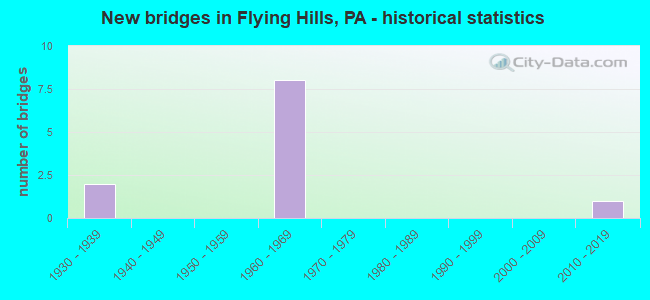
- New bridges - historical statistics
- 21930-1939
- 81960-1969
- 12010-2019

- Reconstructed bridges - Historical Statistics
- 11970-1979
- 21980-1989
- 01990-1999
- 22000-2009


- Bridge Condition - Deck
- 66.7%Good
- 33.3%Satisfactory

- Bridge Condition - Superstructure
- 83.3%Satisfactory
- 16.7%Fair

- Bridge Condition - Channel
- 40.0%Very good
- 20.0%Satisfactory
- 20.0%Fair
- 20.0%Poor
Find on map >> Show street view
Structure Number: 4573, Location: VILLAGE OF GREEN HILLS (Lat: 40.248631, Lng: -75.912139), Route carried "on" structure: State highway 10, Year Built: 1939, Status: Open, Structure Length: 1.10m (3.61ft), Average Daily Traffic: 3,851 (year 2020), Truck Traffic: 7%, Average Future Daily Traffic: 9,723 (year 2032), Design Load: HS 20, Features Intersected: ALLEGHENY CREEK
Minimum Vertical Clearance: 30+ m (98+ ft), Kilometerpoint: 14.053, Lanes on structure: 2, Owner: State Highway Agency, Approaching Roadway Width: 7.9m (25.9ft), Skew: 3 degrees, Material/Design: Concrete, Design/Construction: Tee Beam, Number Of Spans In Main Unit: 1, Length of Maximum Span: 10.1m (33.1ft), Curb-To-Curb Width: 7.1m (23.3ft), Out-to-Out Width: 7.6m (24.9ft)
Condition: Deck: Satisfactory, Superstructure: Satisfactory, Substructure: Fair, Channel: Fair, Operating Rating: 39.0 metric tons, Method Used To Determine Operating Rating: Load Factor (LF), Inventory Rating: 22.7 metric tons, Method Used To Determine Inventory Rating: Load Factor (LF), Structural Evaluation: Somewhat better than minimum adequacy, Deck Geometry: High priority of replacement, Waterway Adequacy: Better than present minimum criteria, Approach Roadway Alignment: Equal to present desirable criteria, Length Of Structure Improvement: 1.70m (5.58ft), Designated Inspection Frequency: Every 24 months, Inspection Date: December 2019, Bridge Improvement Cost: $6,000, Roadway Improvement Cost: $18,000, Total Project Cost: $82,000, Deck Structure Type: Concrete Cast-file-Place, Wearing Surface/Protective System: Wearing Surface: Bituminous
Find on map >> Show street view
Structure Number: 4728, Location: SO. OF PA 568 INTERCHANGE (Lat: 40.248531, Lng: -75.914256), Route carried "on" structure: Interstate 176, Year Built: 1962, Year Reconstructed: 2008, Status: Open, Structure Length: 7.71m (25.30ft), Average Daily Traffic: 11,580 (year 2021), Truck Traffic: 12%, Average Future Daily Traffic: 12,102 (year 2032), Design Load: HL 93, Features Intersected: PA 568 & ALLEGHENY CR.
Minimum Vertical Clearance: 30+ m (98+ ft), Kilometerpoint: 11.269, Lanes on structure: 2, Lanes under structure: 2, Base Highway Network: Yes, Owner: State Highway Agency, Approaching Roadway Width: 11.0m (36.1ft), Skew: 13 degrees, Material/Design: Prestressed concrete, Design/Construction: Box Beam or Girders - Single/Spread, Number Of Spans In Main Unit: 3, Length of Maximum Span: 22.3m (73.2ft), Curb-To-Curb Width: 9.8m (32.2ft), Out-to-Out Width: 10.8m (35.4ft)
Condition: Deck: Good, Superstructure: Satisfactory, Substructure: Fair, Channel: Very good, Operating Rating: 59.9 metric tons, Method Used To Determine Operating Rating: Assigned ratings based on Load and Resistance Factor Design (LRFD) reported in metric tons, Inventory Rating: 20.9 metric tons, Method Used To Determine Inventory Rating: Assigned ratings based on Load and Resistance Factor Design (LRFD) reported in metric tons, Structural Evaluation: Somewhat better than minimum adequacy, Deck Geometry: Meets minimum limits, Underclear: Superior to present desirable criteria, Waterway Adequacy: Superior to present desirable criteria, Approach Roadway Alignment: Equal to present desirable criteria, Length Of Structure Improvement: 7.10m (23.29ft), Designated Inspection Frequency: Every 24 months, Inspection Date: April 2020, Bridge Improvement Cost: $88,000, Roadway Improvement Cost: $259,000, Total Project Cost: $1,188,000, Deck Structure Type: Concrete Cast-file-Place, Wearing Surface/Protective System: Wearing Surface: Monolithic Concrete, Deck Protection: Epoxy Coated Reinforcing
Find on map >> Show street view
Structure Number: 4729, Location: SO. OF PA 568 INTERCHANGE (Lat: 40.248297, Lng: -75.914628), Route carried "on" structure: Interstate 176, Year Built: 1962, Year Reconstructed: 2008, Status: Open, Structure Length: 6.19m (20.31ft), Average Daily Traffic: 10,855 (year 2021), Truck Traffic: 12%, Average Future Daily Traffic: 12,316 (year 2032), Design Load: HL 93, Features Intersected: PA 568 & ALLEGHENY CR
Minimum Vertical Clearance: 30+ m (98+ ft), Kilometerpoint: 11.293, Lanes on structure: 2, Lanes under structure: 2, Base Highway Network: Yes, Owner: State Highway Agency, Approaching Roadway Width: 11.0m (36.1ft), Skew: 13 degrees, Material/Design: Prestressed concrete, Design/Construction: Box Beam or Girders - Single/Spread, Number Of Spans In Main Unit: 3, Length of Maximum Span: 22.3m (73.2ft), Curb-To-Curb Width: 9.8m (32.2ft), Out-to-Out Width: 10.8m (35.4ft)
Condition: Deck: Good, Superstructure: Satisfactory, Substructure: Fair, Channel: Very good, Operating Rating: 59.9 metric tons, Method Used To Determine Operating Rating: Assigned ratings based on Load and Resistance Factor Design (LRFD) reported in metric tons, Inventory Rating: 20.9 metric tons, Method Used To Determine Inventory Rating: Assigned ratings based on Load and Resistance Factor Design (LRFD) reported in metric tons, Structural Evaluation: Somewhat better than minimum adequacy, Deck Geometry: Meets minimum limits, Underclear: Equal to present minimum criteria, Waterway Adequacy: Superior to present desirable criteria, Approach Roadway Alignment: Equal to present desirable criteria, Length Of Structure Improvement: 7.10m (23.29ft), Designated Inspection Frequency: Every 24 months, Inspection Date: April 2020, Bridge Improvement Cost: $19,000, Roadway Improvement Cost: $56,000, Total Project Cost: $258,000, Deck Structure Type: Concrete Cast-file-Place, Wearing Surface/Protective System: Wearing Surface: Monolithic Concrete, Deck Protection: Epoxy Coated Reinforcing
Find on map >> Show street view
Structure Number: 4731, Location: 4 MI.S.OF US422 (Lat: 40.259944, Lng: -75.914222), Route carried "on" structure: Interstate 176, Year Built: 1962, Year Reconstructed: 1988, Status: Open, Structure Length: 3.90m (12.80ft), Average Daily Traffic: 11,580 (year 2021), Truck Traffic: 12%, Average Future Daily Traffic: 12,102 (year 2032), Design Load: HS 20+Mod, Features Intersected: PA 10 (LR 274)
Minimum Vertical Clearance: 30+ m (98+ ft), Kilometerpoint: 12.073, Lanes on structure: 2, Lanes under structure: 2, Base Highway Network: Yes, Owner: State Highway Agency, Approaching Roadway Width: 13.1m (43.0ft), Skew: 13 degrees, Material/Design: Prestressed concrete, Design/Construction: Stringer/Multi-beam, Number Of Spans In Main Unit: 3, Length of Maximum Span: 15.2m (49.9ft), Curb-To-Curb Width: 13.1m (43.0ft), Out-to-Out Width: 14.2m (46.6ft)
Condition: Deck: Good, Superstructure: Satisfactory, Substructure: Fair, Operating Rating: 63.5 metric tons, Method Used To Determine Operating Rating: Load Factor (LF), Inventory Rating: 29.9 metric tons, Method Used To Determine Inventory Rating: Load Factor (LF), Structural Evaluation: Somewhat better than minimum adequacy, Deck Geometry: Superior to present desirable criteria, Underclear: Superior to present desirable criteria, Approach Roadway Alignment: Equal to present desirable criteria, Length Of Structure Improvement: 5.80m (19.03ft), Designated Inspection Frequency: Every 24 months, Inspection Date: March 2020, Deck Structure Type: Concrete Cast-file-Place, Wearing Surface/Protective System: Wearing Surface: Monolithic Concrete, Deck Protection: Epoxy Coated Reinforcing
Find on map >> Show street view
Structure Number: 4733, Location: 4 MI.S.OF US422 (Lat: 40.260031, Lng: -75.914567), Route carried "on" structure: Interstate 176, Year Built: 1962, Year Reconstructed: 1988, Status: Open, Structure Length: 4.11m (13.48ft), Average Daily Traffic: 10,855 (year 2021), Truck Traffic: 12%, Average Future Daily Traffic: 12,316 (year 2032), Design Load: HS 20+Mod, Features Intersected: PA 10 (LR 274)
Minimum Vertical Clearance: 30+ m (98+ ft), Kilometerpoint: 12.093, Lanes on structure: 2, Lanes under structure: 2, Base Highway Network: Yes, Owner: State Highway Agency, Approaching Roadway Width: 13.1m (43.0ft), Skew: 13 degrees, Material/Design: Prestressed concrete, Design/Construction: Stringer/Multi-beam, Number Of Spans In Main Unit: 3, Length of Maximum Span: 15.2m (49.9ft), Curb-To-Curb Width: 13.1m (43.0ft), Out-to-Out Width: 13.9m (45.6ft)
Condition: Deck: Good, Superstructure: Satisfactory, Substructure: Fair, Operating Rating: 63.5 metric tons, Method Used To Determine Operating Rating: Load Factor (LF), Inventory Rating: 29.9 metric tons, Method Used To Determine Inventory Rating: Load Factor (LF), Structural Evaluation: Somewhat better than minimum adequacy, Deck Geometry: Superior to present desirable criteria, Underclear: Equal to present minimum criteria, Approach Roadway Alignment: Equal to present desirable criteria, Length Of Structure Improvement: 5.00m (16.40ft), Designated Inspection Frequency: Every 24 months, Inspection Date: March 2020, Deck Structure Type: Concrete Cast-file-Place, Wearing Surface/Protective System: Wearing Surface: Monolithic Concrete, Deck Protection: Epoxy Coated Reinforcing
Find on map >> Show street view
Structure Number: 4892, Location: GREEN HILLS ROAD (Lat: 40.265844, Lng: -75.897311), Route carried "on" structure: State highway 568, Year Built: 1937, Year Reconstructed: 1978, Status: Open, Structure Length: 2.10m (6.89ft), Average Daily Traffic: 1,721 (year 2021), Truck Traffic: 4%, Average Future Daily Traffic: 3,076 (year 2032), Design Load: HS 20, Features Intersected: ALLEGHENY CREEK
Minimum Vertical Clearance: 30+ m (98+ ft), Kilometerpoint: 13.858, Lanes on structure: 2, Owner: State Highway Agency, Approaching Roadway Width: 6.7m (22.0ft), Skew: 3 degrees, Material/Design: Steel, Design/Construction: Stringer/Multi-beam, Number Of Spans In Main Unit: 1, Length of Maximum Span: 20.7m (67.9ft), Curb-To-Curb Width: 6.7m (22.0ft), Out-to-Out Width: 7.8m (25.6ft)
Condition: Deck: Satisfactory, Superstructure: Fair, Substructure: Fair, Channel: Poor, Operating Rating: 92.5 metric tons, Method Used To Determine Operating Rating: Load Factor (LF), Inventory Rating: 55.3 metric tons, Method Used To Determine Inventory Rating: Load Factor (LF), Structural Evaluation: Somewhat better than minimum adequacy, Deck Geometry: High priority of corrective action, Waterway Adequacy: Equal to present minimum criteria, Approach Roadway Alignment: Better than present minimum criteria, Length Of Structure Improvement: 2.80m (9.19ft), Designated Inspection Frequency: Every 24 months, Inspection Date: September 2020, Bridge Improvement Cost: $17,000, Roadway Improvement Cost: $49,000, Total Project Cost: $224,000, Deck Structure Type: Concrete Cast-file-Place, Wearing Surface/Protective System: Wearing Surface: Monolithic Concrete, Deck Protection: Epoxy Coated Reinforcing
Find on map >> Show street view
Structure Number: 49101, Location: 125 FT. E OF RTE. 568 (Lat: 40.266508, Lng: -75.896314), Route carried "on" structure: City street T344, Year Built: 2015, Status: Open, Structure Length: 1.37m (4.49ft), Average Daily Traffic: 50 (year 1985), Average Future Daily Traffic: 70 (year 2005), Design Load: HS 25 or greater, Features Intersected: ALLEGHENY CREEK, Facility Carried by Structure: EVERGREEN ROAD
Minimum Vertical Clearance: 30+ m (98+ ft), Kilometerpoint: 0.000, Lanes on structure: 2, Owner: Town or Township Highway Agency, Approaching Roadway Width: 3.7m (12.1ft), Material/Design: Concrete, Design/Construction: Culvert, Number Of Spans In Main Unit: 1, Length of Maximum Span: 13.7m (44.9ft), Curb-To-Curb Width: 6.2m (20.3ft), Out-to-Out Width: 6.3m (20.7ft)
Condition: Channel: Satisfactory, Culverts: Good, Operating Rating: 66.2 metric tons, Method Used To Determine Operating Rating: Assigned rating based on Load Factor Design (LFD) reported in metric tons, Inventory Rating: 48.1 metric tons, Method Used To Determine Inventory Rating: Assigned rating based on Load Factor Design (LFD) reported in metric tons, Structural Evaluation: Better than present minimum criteria, Deck Geometry: Somewhat better than minimum adequacy, Waterway Adequacy: Meets minimum limits, Approach Roadway Alignment: Equal to present desirable criteria, Designated Inspection Frequency: Every 24 months, Inspection Date: July 2021
Find on map >> Show street view
Structure Number: 4728, Location: SO. OF PA 568 INTERCHANGE (Lat: 40.248531, Lng: -75.914256), Route carried "under" structure: State highway 568, Year Built: 1962, Structure Length: 0. m, Average Daily Traffic: 1,276 (year 2020), Truck Traffic: 7%, Features Intersected: PA 568 & ALLEGHENY CR., Facility Carried by Structure: I-176 NB (LR 1011)
Minimum Vertical Clearance: 6.17m (20.24ft), Kilometerpoint: 11.423, Lanes on structure: 2, Lanes under structure: 2, Material/Design: Prestressed concrete, Design/Construction: Box Beam or Girders - Single/Spread, Length of Maximum Span: 22.3m (73.2ft)
Find on map >> Show street view
Structure Number: 4729, Location: SO. OF PA 568 INTERCHANGE (Lat: 40.248297, Lng: -75.914628), Route carried "under" structure: State highway 568, Year Built: 1962, Structure Length: 0. m, Average Daily Traffic: 1,276 (year 2020), Truck Traffic: 7%, Features Intersected: PA 568 & ALLEGHENY CR, Facility Carried by Structure: I-176 SB (LR 1011)
Minimum Vertical Clearance: 4.54m (14.90ft), Kilometerpoint: 11.423, Lanes on structure: 2, Lanes under structure: 2, Material/Design: Prestressed concrete, Design/Construction: Box Beam or Girders - Single/Spread, Length of Maximum Span: 22.3m (73.2ft)
Find on map >> Show street view
Structure Number: 4731, Location: 4 MI.S.OF US422 (Lat: 40.259944, Lng: -75.914222), Route carried "under" structure: State highway 10, Year Built: 1962, Structure Length: 0. m, Average Daily Traffic: 7,699 (year 2022), Truck Traffic: 3%, Features Intersected: PA 10 (LR 274)
Minimum Vertical Clearance: 5.70m (18.70ft), Kilometerpoint: 15.485, Lanes on structure: 2, Lanes under structure: 2, Material/Design: Prestressed concrete, Design/Construction: Stringer/Multi-beam, Length of Maximum Span: 15.2m (49.9ft)
Find on map >> Show street view
Structure Number: 4733, Location: 4 MI.S.OF US422 (Lat: 40.260031, Lng: -75.914567), Route carried "under" structure: State highway 10, Year Built: 1962, Structure Length: 0. m, Average Daily Traffic: 7,699 (year 2022), Truck Traffic: 3%, Features Intersected: PA 10 (LR 274)
Minimum Vertical Clearance: 4.57m (14.99ft), Kilometerpoint: 15.485, Lanes on structure: 2, Lanes under structure: 2, Material/Design: Prestressed concrete, Design/Construction: Stringer/Multi-beam, Length of Maximum Span: 15.2m (49.9ft)