Bridge Statistics for Frederica, Delaware (DE)
Condition, Traffic, Stress, Structural Evaluation, Project Costs
- National Bridge Inventory (NBI) Statistics
- 18Number of bridges
- 322ft / 98.2mTotal length
- 192,623Total average daily traffic
- 17,782Total average daily truck traffic
- National Bridge Inventory (NBI) Registered Bridges for Frederica
- No street view available for this location
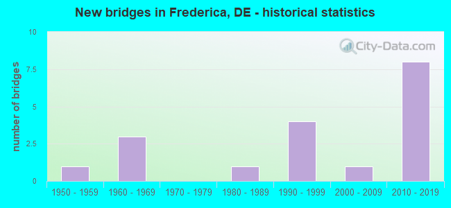
- New bridges - historical statistics
- 11950-1959
- 31960-1969
- 11980-1989
- 41990-1999
- 12000-2009
- 82010-2019


- Bridge Condition - Deck
- 25.0%Very good
- 50.0%Good
- 25.0%Satisfactory

- Bridge Condition - Superstructure
- 25.0%Very good
- 33.3%Good
- 41.7%Satisfactory

- Bridge Condition - Substructure
- 16.7%Very good
- 41.7%Good
- 16.7%Satisfactory
- 25.0%Fair

- Bridge Condition - Channel
- 30.0%Very good
- 40.0%Good
- 30.0%Satisfactory
Find on map >> Show street view
Structure Number: 2008C12, Location: SOUTH OF FREDERICA (Lat: 38.990917, Lng: -75.449000), Route carried "on" structure: County highway 120, Year Built: 2018, Status: Open, Structure Length: 5.76m (18.90ft), Average Daily Traffic: 213 (year 2019), Truck Traffic: 10%, Average Future Daily Traffic: 1,030 (year 2040), Design Load: HL 93, Features Intersected: SR1 / BAY RD, Facility Carried by Structure: MILFORD NECK RD
Minimum Vertical Clearance: 30.48m (100.00ft), Kilometerpoint: 0.177, Lanes on structure: 2, Lanes under structure: 4, Owner: State Highway Agency, Approaching Roadway Width: 17.1m (56.1ft), Material/Design: Prestressed concrete continuous, Design/Construction: Stringer/Multi-beam, Number Of Spans In Main Unit: 2, Length of Maximum Span: 28.3m (92.8ft), Curb-To-Curb Width: 17.1m (56.1ft), Out-to-Out Width: 17.8m (58.4ft)
Condition: Deck: Good, Superstructure: Very good, Substructure: Very good, Operating Rating: 46.3 metric tons, Method Used To Determine Operating Rating: Load and Resistance Factor Rating (LRFR) rating reported by rating factor(RF) method using HL-93 loadings, Inventory Rating: 31.8 metric tons, Method Used To Determine Inventory Rating: Load and Resistance Factor Rating (LRFR) rating reported by rating factor(RF) method using HL-93 loadings, Structural Evaluation: Better than present minimum criteria, Deck Geometry: Superior to present desirable criteria, Underclear: Superior to present desirable criteria, Approach Roadway Alignment: Equal to present desirable criteria, Designated Inspection Frequency: Every 24 months, Inspection Date: November 2020, Deck Structure Type: Concrete Cast-file-Place, Wearing Surface/Protective System: Wearing Surface: Monolithic Concrete, Deck Protection: Epoxy Coated Reinforcing
Find on map >> Show street view
Structure Number: 2008E010A, Location: FREDERICA (Lat: 39.014861, Lng: -75.460861), Route carried "on" structure: County highway 10A, Year Built: 2011, Status: Open, Structure Length: 6.12m (20.08ft), Average Daily Traffic: 1,213 (year 2020), Truck Traffic: 7%, Average Future Daily Traffic: 1,904 (year 2039), Design Load: HS 20+Mod, Features Intersected: SR1 BAY RD., Facility Carried by Structure: FREDERICA RD.
Minimum Vertical Clearance: 30.48m (100.00ft), Kilometerpoint: 3.187, Lanes on structure: 2, Lanes under structure: 5, Owner: State Highway Agency, Approaching Roadway Width: 13.4m (44.0ft), Material/Design: Steel continuous, Design/Construction: Stringer/Multi-beam, Number Of Spans In Main Unit: 2, Length of Maximum Span: 28.1m (92.2ft), Curb-To-Curb Width: 13.4m (44.0ft), Out-to-Out Width: 14.9m (48.9ft)
Condition: Deck: Good, Superstructure: Good, Substructure: Good, Operating Rating: 33.0 metric tons, Method Used To Determine Operating Rating: Load and Resistance Factor Rating (LRFR) rating reported by rating factor(RF) method using HL-93 loadings, Inventory Rating: 25.6 metric tons, Method Used To Determine Inventory Rating: Load and Resistance Factor Rating (LRFR) rating reported by rating factor(RF) method using HL-93 loadings, Structural Evaluation: Equal to present minimum criteria, Deck Geometry: Equal to present desirable criteria, Underclear: Better than present minimum criteria, Approach Roadway Alignment: Equal to present desirable criteria, Designated Inspection Frequency: Every 24 months, Inspection Date: July 2021, Deck Structure Type: Concrete Cast-file-Place, Wearing Surface/Protective System: Wearing Surface: Monolithic Concrete, Deck Protection: Epoxy Coated Reinforcing
Find on map >> Show street view
Structure Number: 2008F01, Location: FREDERICA (Lat: 39.002656, Lng: -75.463961), Route carried "on" structure: County highway 10, Year Built: 2000, Status: Open, Structure Length: 3.87m (12.70ft), Average Daily Traffic: 2,123 (year 2019), Truck Traffic: 9%, Average Future Daily Traffic: 2,638 (year 2042), Design Load: H 20, Features Intersected: MURDERKILL RIVER, Facility Carried by Structure: FREDERICA RD
Minimum Vertical Clearance: 30.48m (100.00ft), Kilometerpoint: 1.642, Lanes on structure: 2, Owner: State Highway Agency, Approaching Roadway Width: 7.3m (24.0ft), Navigation Control: Yes ( Vertical Clearance: 1.0m (3.3ft), Horizontal Clearance: 8.0m (26.2ft)), Material/Design: Prestressed concrete, Design/Construction: Box Beam or Girders - Multiple, Number Of Spans In Main Unit: 2, Length of Maximum Span: 17.8m (58.4ft), Curb-To-Curb Width: 12.2m (40.0ft), Out-to-Out Width: 13.0m (42.7ft)
Condition: Deck: Very good, Superstructure: Good, Substructure: Good, Channel: Very good, Operating Rating: 65.1 metric tons, Method Used To Determine Operating Rating: Load and Resistance Factor Rating (LRFR) rating reported by rating factor(RF) method using HL-93 loadings, Inventory Rating: 49.9 metric tons, Method Used To Determine Inventory Rating: Load and Resistance Factor Rating (LRFR) rating reported by rating factor(RF) method using HL-93 loadings, Structural Evaluation: Better than present minimum criteria, Deck Geometry: Equal to present minimum criteria, Waterway Adequacy: Equal to present minimum criteria, Approach Roadway Alignment: Equal to present desirable criteria, Designated Inspection Frequency: Every 24 months, Underwater Inspection Frequency: Every 48 months, Inspection Date: August 2020, Underwater Inspection Date: June 2020, Deck Structure Type: Concrete Cast-file-Place, Wearing Surface/Protective System: Wearing Surface: Monolithic Concrete, Deck Protection: Epoxy Coated Reinforcing
Find on map >> Show street view
Structure Number: 2008G01, Location: FREDERICA (Lat: 39.013550, Lng: -75.463539), Route carried "on" structure: State highway 12, Year Built: 1996, Status: Open, Structure Length: 3.09m (10.14ft), Average Daily Traffic: 2,151 (year 2019), Truck Traffic: 8%, Average Future Daily Traffic: 2,673 (year 2042), Design Load: HS 25 or greater, Features Intersected: SPRING CREEK
Minimum Vertical Clearance: 30.48m (100.00ft), Kilometerpoint: 2.865, Lanes on structure: 2, Owner: State Highway Agency, Approaching Roadway Width: 7.2m (23.6ft), Material/Design: Prestressed concrete, Design/Construction: Box Beam or Girders - Multiple, Number Of Spans In Main Unit: 1, Length of Maximum Span: 28.0m (91.9ft), Curb or Sidewalk Widths: Left: 0.0m, Right: 2.0m (6.6ft), Curb-To-Curb Width: 13.2m (43.3ft), Out-to-Out Width: 17.3m (56.8ft)
Condition: Deck: Good, Superstructure: Good, Substructure: Good, Channel: Very good, Operating Rating: 69.7 metric tons, Method Used To Determine Operating Rating: Load and Resistance Factor Rating (LRFR) rating reported by rating factor(RF) method using HL-93 loadings, Inventory Rating: 44.1 metric tons, Method Used To Determine Inventory Rating: Load and Resistance Factor Rating (LRFR) rating reported by rating factor(RF) method using HL-93 loadings, Structural Evaluation: Better than present minimum criteria, Deck Geometry: Equal to present minimum criteria, Waterway Adequacy: Equal to present minimum criteria, Approach Roadway Alignment: Equal to present desirable criteria, Designated Inspection Frequency: Every 24 months, Inspection Date: August 2020, Bridge Improvement Cost: $1,000, Deck Structure Type: Concrete Cast-file-Place, Wearing Surface/Protective System: Wearing Surface: Monolithic Concrete, Deck Protection: Epoxy Coated Reinforcing
Find on map >> Show street view
Structure Number: 2008H008, Location: FREDERICA BYPASS (Lat: 39.011111, Lng: -75.459075), Route carried "on" structure: US 113, Year Built: 1965, Status: Open, Structure Length: 30.48m (100.00ft), Average Daily Traffic: 22,490 (year 2019), Truck Traffic: 10%, Average Future Daily Traffic: 27,953 (year 2042), Design Load: HS 20+Mod, Features Intersected: MURDERKILL RIVER
Minimum Vertical Clearance: 30.48m (100.00ft), Kilometerpoint: 11.770, Lanes on structure: 2, Base Highway Network: Yes, Owner: State Highway Agency, Approaching Roadway Width: 10.4m (34.1ft), Navigation Control: Yes ( Vertical Clearance: 4.5m (14.8ft), Horizontal Clearance: 15.0m (49.2ft)), Material/Design: Steel, Design/Construction: Stringer/Multi-beam, Number Of Spans In Main Unit: 13, Length of Maximum Span: 33.9m (111.2ft), Curb-To-Curb Width: 9.1m (29.9ft), Out-to-Out Width: 10.5m (34.4ft)
Condition: Deck: Satisfactory, Superstructure: Good, Substructure: Fair, Channel: Satisfactory, Operating Rating: 38.6 metric tons, Method Used To Determine Operating Rating: Load and Resistance Factor Rating (LRFR) rating reported by rating factor(RF) method using HL-93 loadings, Inventory Rating: 29.8 metric tons, Method Used To Determine Inventory Rating: Load and Resistance Factor Rating (LRFR) rating reported by rating factor(RF) method using HL-93 loadings, Structural Evaluation: Somewhat better than minimum adequacy, Deck Geometry: Meets minimum limits, Waterway Adequacy: Equal to present desirable criteria, Approach Roadway Alignment: Equal to present desirable criteria, Designated Inspection Frequency: Every 24 months, Underwater Inspection Frequency: Every 24 months, Inspection Date: October 2020, Underwater Inspection Date: June 2020, Deck Structure Type: Concrete Cast-file-Place, Wearing Surface/Protective System: Wearing Surface: Latex Concrete
Find on map >> Show street view
Structure Number: 2008I008, Location: FREDERICA BYPASS (Lat: 39.010964, Lng: -75.458750), Route carried "on" structure: US 113, Year Built: 1965, Year Reconstructed: 2000, Status: Open, Structure Length: 30.48m (100.00ft), Average Daily Traffic: 22,490 (year 2019), Truck Traffic: 10%, Average Future Daily Traffic: 27,953 (year 2042), Design Load: HS 20+Mod, Features Intersected: MURDERKILL RIVER
Minimum Vertical Clearance: 30.48m (100.00ft), Kilometerpoint: 11.770, Lanes on structure: 2, Base Highway Network: Yes, Owner: State Highway Agency, Approaching Roadway Width: 11.8m (38.7ft), Navigation Control: Yes ( Vertical Clearance: 4.3m (14.1ft), Horizontal Clearance: 15.2m (49.9ft)), Material/Design: Steel, Design/Construction: Stringer/Multi-beam, Number Of Spans In Main Unit: 13, Length of Maximum Span: 33.9m (111.2ft), Curb-To-Curb Width: 9.1m (29.9ft), Out-to-Out Width: 10.5m (34.4ft)
Condition: Deck: Satisfactory, Superstructure: Satisfactory, Substructure: Fair, Channel: Satisfactory, Operating Rating: 38.6 metric tons, Method Used To Determine Operating Rating: Load and Resistance Factor Rating (LRFR) rating reported by rating factor(RF) method using HL-93 loadings, Inventory Rating: 29.8 metric tons, Method Used To Determine Inventory Rating: Load and Resistance Factor Rating (LRFR) rating reported by rating factor(RF) method using HL-93 loadings, Structural Evaluation: Somewhat better than minimum adequacy, Deck Geometry: Meets minimum limits, Waterway Adequacy: Equal to present desirable criteria, Approach Roadway Alignment: Equal to present desirable criteria, Designated Inspection Frequency: Every 24 months, Underwater Inspection Frequency: Every 24 months, Inspection Date: October 2020, Underwater Inspection Date: June 2020, Deck Structure Type: Concrete Cast-file-Place, Wearing Surface/Protective System: Wearing Surface: Latex Concrete
Find on map >> Show street view
Structure Number: 2008K008, Location: LITTLE HEAVEN (Lat: 39.041750, Lng: -75.456750), Route carried "on" structure: State highway 1, Year Built: 2019, Status: Open, Structure Length: 3.86m (12.66ft), Average Daily Traffic: 23,657 (year 2019), Truck Traffic: 8%, Average Future Daily Traffic: 29,680 (year 2039), Design Load: HL 93, Features Intersected: BOWERS BEACH RD
Minimum Vertical Clearance: 30.48m (100.00ft), Kilometerpoint: 35.422, Lanes on structure: 2, Lanes under structure: 5, Base Highway Network: Yes, Owner: State Highway Agency, Approaching Roadway Width: 12.6m (41.3ft), Material/Design: Steel, Design/Construction: Stringer/Multi-beam, Number Of Spans In Main Unit: 1, Number Of Approach Spans: 2, Length of Maximum Span: 37.4m (122.7ft), Curb-To-Curb Width: 12.8m (42.0ft), Out-to-Out Width: 13.4m (44.0ft)
Condition: Deck: Very good, Superstructure: Very good, Substructure: Good, Operating Rating: 54.1 metric tons, Method Used To Determine Operating Rating: Load and Resistance Factor Rating (LRFR) rating reported by rating factor(RF) method using HL-93 loadings, Inventory Rating: 41.8 metric tons, Method Used To Determine Inventory Rating: Load and Resistance Factor Rating (LRFR) rating reported by rating factor(RF) method using HL-93 loadings, Structural Evaluation: Better than present minimum criteria, Deck Geometry: Equal to present desirable criteria, Underclear: Meets minimum limits, Approach Roadway Alignment: Equal to present desirable criteria, Designated Inspection Frequency: Every 24 months, Inspection Date: March 2021, Deck Structure Type: Concrete Cast-file-Place, Wearing Surface/Protective System: Wearing Surface: Monolithic Concrete, Deck Protection: Epoxy Coated Reinforcing
Find on map >> Show street view
Structure Number: 2008L008, Location: LITTLE HEAVEN (Lat: 39.041750, Lng: -75.456472), Route carried "on" structure: State highway 1, Year Built: 2019, Status: Open, Structure Length: 3.86m (12.66ft), Average Daily Traffic: 23,657 (year 2019), Truck Traffic: 10%, Average Future Daily Traffic: 29,680 (year 2039), Design Load: HL 93, Features Intersected: BOWERS BEACH RD
Minimum Vertical Clearance: 30.48m (100.00ft), Kilometerpoint: 15.466, Lanes on structure: 2, Lanes under structure: 5, Owner: State Highway Agency, Approaching Roadway Width: 12.0m (39.4ft), Material/Design: Steel, Design/Construction: Stringer/Multi-beam, Number Of Spans In Main Unit: 1, Length of Maximum Span: 37.4m (122.7ft), Curb-To-Curb Width: 12.8m (42.0ft), Out-to-Out Width: 13.7m (44.9ft)
Condition: Deck: Very good, Superstructure: Very good, Substructure: Very good, Operating Rating: 54.1 metric tons, Method Used To Determine Operating Rating: Load and Resistance Factor Rating (LRFR) rating reported by rating factor(RF) method using HL-93 loadings, Inventory Rating: 41.8 metric tons, Method Used To Determine Inventory Rating: Load and Resistance Factor Rating (LRFR) rating reported by rating factor(RF) method using HL-93 loadings, Structural Evaluation: Equal to present desirable criteria, Deck Geometry: Equal to present desirable criteria, Underclear: Meets minimum limits, Approach Roadway Alignment: Equal to present desirable criteria, Designated Inspection Frequency: Every 24 months, Inspection Date: March 2021, Deck Structure Type: Concrete Cast-file-Place, Wearing Surface/Protective System: Wearing Surface: Monolithic Concrete, Deck Protection: Epoxy Coated Reinforcing
Find on map >> Show street view
Structure Number: 2035A035, Location: S.W. OF FREDERICA (Lat: 38.989133, Lng: -75.494208), Route carried "on" structure: County highway 35, Year Built: 1962, Status: Open, Structure Length: 2.44m (8.01ft), Average Daily Traffic: 1,654 (year 2020), Truck Traffic: 9%, Average Future Daily Traffic: 2,055 (year 2043), Design Load: HS 20, Features Intersected: MURDERKILL RIVER, Facility Carried by Structure: CARPENTER BRIDGE
Minimum Vertical Clearance: 30.48m (100.00ft), Kilometerpoint: 9.109, Lanes on structure: 2, Owner: State Highway Agency, Approaching Roadway Width: 6.9m (22.6ft), Material/Design: Prestressed concrete, Design/Construction: Box Beam or Girders - Multiple, Number Of Spans In Main Unit: 2, Length of Maximum Span: 11.5m (37.7ft), Curb-To-Curb Width: 11.1m (36.4ft), Out-to-Out Width: 12.2m (40.0ft)
Condition: Deck: Good, Superstructure: Satisfactory, Substructure: Fair, Channel: Good, Operating Rating: 71.6 metric tons, Method Used To Determine Operating Rating: Load and Resistance Factor Rating (LRFR) rating reported by rating factor(RF) method using HL-93 loadings, Inventory Rating: 55.4 metric tons, Method Used To Determine Inventory Rating: Load and Resistance Factor Rating (LRFR) rating reported by rating factor(RF) method using HL-93 loadings, Structural Evaluation: Somewhat better than minimum adequacy, Deck Geometry: Equal to present minimum criteria, Waterway Adequacy: Equal to present minimum criteria, Approach Roadway Alignment: Equal to present minimum criteria, Designated Inspection Frequency: Every 24 months, Underwater Inspection Frequency: Every 24 months, Inspection Date: July 2021, Underwater Inspection Date: April 2021, Deck Structure Type: Concrete Precast Panels, Wearing Surface/Protective System: Wearing Surface: Bituminous
Find on map >> Show street view
Structure Number: 2035B035, Location: S/W OF FREDERICA (Lat: 39.001439, Lng: -75.489333), Route carried "on" structure: County highway 35, Year Built: 1991, Status: Open, Structure Length: 0.64m (2.10ft), Average Daily Traffic: 2,080 (year 2019), Truck Traffic: 10%, Average Future Daily Traffic: 2,585 (year 2042), Design Load: HS 25 or greater, Features Intersected: ASH GUT, Facility Carried by Structure: CARPENTER BRIDGE R
Minimum Vertical Clearance: 30.48m (100.00ft), Kilometerpoint: 10.557, Lanes on structure: 2, Owner: State Highway Agency, Approaching Roadway Width: 6.3m (20.7ft), Material/Design: Concrete, Design/Construction: Culvert, Number Of Spans In Main Unit: 2, Length of Maximum Span: 3.0m (9.8ft), Curb-To-Curb Width: 13.2m (43.3ft), Out-to-Out Width: 14.2m (46.6ft)
Condition: Channel: Good, Culverts: Good, Operating Rating: 66.7 metric tons, Method Used To Determine Operating Rating: Load and Resistance Factor Rating (LRFR) rating reported by rating factor(RF) method using HL-93 loadings, Inventory Rating: 47.0 metric tons, Method Used To Determine Inventory Rating: Load and Resistance Factor Rating (LRFR) rating reported by rating factor(RF) method using HL-93 loadings, Structural Evaluation: Better than present minimum criteria, Deck Geometry: Equal to present minimum criteria, Waterway Adequacy: Equal to present minimum criteria, Approach Roadway Alignment: Equal to present desirable criteria, Designated Inspection Frequency: Every 24 months, Inspection Date: September 2020, Deck Structure Type: Concrete Cast-file-Place, Wearing Surface/Protective System: Wearing Surface: Bituminous, Deck Protection: Epoxy Coated Reinforcing
Find on map >> Show street view
Structure Number: 2035C035, Location: WEST OF FREDERICA (Lat: 39.003972, Lng: -75.484692), Route carried "on" structure: County highway 35, Year Built: 1997, Status: Open, Structure Length: 0.67m (2.20ft), Average Daily Traffic: 1,725 (year 2020), Truck Traffic: 9%, Average Future Daily Traffic: 2,144 (year 2043), Design Load: HS 20, Features Intersected: ASH GUT, Facility Carried by Structure: CARPENTERBRIDGE RD
Minimum Vertical Clearance: 30.48m (100.00ft), Kilometerpoint: 11.104, Lanes on structure: 2, Base Highway Network: Yes, Owner: State Highway Agency, Approaching Roadway Width: 6.4m (21.0ft), Skew: 4 degrees, Material/Design: Concrete, Design/Construction: Culvert, Number Of Spans In Main Unit: 2, Length of Maximum Span: 2.5m (8.2ft)
Condition: Channel: Very good, Culverts: Good, Operating Rating: 54.4 metric tons, Method Used To Determine Operating Rating: Field evaluation and documented engineering judgment, Inventory Rating: 32.7 metric tons, Method Used To Determine Inventory Rating: Field evaluation and documented engineering judgment, Structural Evaluation: Better than present minimum criteria, Waterway Adequacy: Equal to present minimum criteria, Approach Roadway Alignment: Equal to present desirable criteria, Designated Inspection Frequency: Every 24 months, Inspection Date: July 2021
Find on map >> Show street view
Structure Number: 2388B388, Location: McCOLLEY'S POND (Lat: 38.967369, Lng: -75.492978), Route carried "on" structure: State highway 15, Year Built: 1984, Status: Open, Structure Length: 2.43m (7.97ft), Average Daily Traffic: 5,231 (year 2020), Truck Traffic: 9%, Average Future Daily Traffic: 6,501 (year 2043), Design Load: HS 20, Features Intersected: McCOLLEY'S POND
Minimum Vertical Clearance: 30.48m (100.00ft), Kilometerpoint: 5.858, Lanes on structure: 2, Owner: State Highway Agency, Approaching Roadway Width: 7.6m (24.9ft), Material/Design: Steel, Design/Construction: Stringer/Multi-beam, Number Of Spans In Main Unit: 1, Length of Maximum Span: 22.3m (73.2ft), Curb-To-Curb Width: 13.4m (44.0ft), Out-to-Out Width: 14.4m (47.2ft)
Condition: Deck: Good, Superstructure: Satisfactory, Substructure: Satisfactory, Channel: Good, Operating Rating: 92.7 metric tons, Method Used To Determine Operating Rating: Load and Resistance Factor Rating (LRFR) rating reported by rating factor(RF) method using HL-93 loadings, Inventory Rating: 71.6 metric tons, Method Used To Determine Inventory Rating: Load and Resistance Factor Rating (LRFR) rating reported by rating factor(RF) method using HL-93 loadings, Structural Evaluation: Equal to present minimum criteria, Deck Geometry: Equal to present minimum criteria, Waterway Adequacy: Equal to present desirable criteria, Approach Roadway Alignment: Equal to present desirable criteria, Designated Inspection Frequency: Every 24 months, Inspection Date: July 2021, Deck Structure Type: Concrete Cast-file-Place, Wearing Surface/Protective System: Wearing Surface: Monolithic Concrete, Deck Protection: Epoxy Coated Reinforcing
Find on map >> Show street view
Structure Number: 2389A389, Location: FREDERICA (Lat: 39.001969, Lng: -75.465581), Route carried "on" structure: County highway 389, Year Built: 1996, Status: Open, Structure Length: 3.23m (10.60ft), Average Daily Traffic: 398 (year 2020), Truck Traffic: 8%, Average Future Daily Traffic: 494 (year 2043), Design Load: HS 25 or greater, Features Intersected: MURDERKILL RIVER, Facility Carried by Structure: MARKET ST
Minimum Vertical Clearance: 30.48m (100.00ft), Kilometerpoint: 0.113, Lanes on structure: 2, Owner: State Highway Agency, Approaching Roadway Width: 6.7m (22.0ft), Material/Design: Prestressed concrete, Design/Construction: Box Beam or Girders - Multiple, Number Of Spans In Main Unit: 2, Length of Maximum Span: 15.6m (51.2ft), Curb-To-Curb Width: 9.0m (29.5ft), Out-to-Out Width: 9.8m (32.2ft)
Condition: Deck: Good, Superstructure: Satisfactory, Substructure: Good, Channel: Satisfactory, Operating Rating: 53.1 metric tons, Method Used To Determine Operating Rating: Load and Resistance Factor Rating (LRFR) rating reported by rating factor(RF) method using HL-93 loadings, Inventory Rating: 37.3 metric tons, Method Used To Determine Inventory Rating: Load and Resistance Factor Rating (LRFR) rating reported by rating factor(RF) method using HL-93 loadings, Structural Evaluation: Equal to present minimum criteria, Deck Geometry: Equal to present minimum criteria, Waterway Adequacy: Better than present minimum criteria, Approach Roadway Alignment: Equal to present desirable criteria, Designated Inspection Frequency: Every 24 months, Underwater Inspection Frequency: Every 48 months, Inspection Date: July 2021, Underwater Inspection Date: April 2019, Bridge Improvement Cost: $1,000, Deck Structure Type: Concrete Cast-file-Place, Wearing Surface/Protective System: Wearing Surface: Monolithic Concrete, Deck Protection: Epoxy Coated Reinforcing
Find on map >> Show street view
Structure Number: 2390C39, Location: S.W. OF FREDERICA (Lat: 38.982078, Lng: -75.480086), Route carried "on" structure: County highway 390, Year Built: 1957, Status: Open, Structure Length: 1.31m (4.30ft), Average Daily Traffic: 248 (year 2019), Truck Traffic: 9%, Average Future Daily Traffic: 308 (year 2042), Design Load: HS 20, Features Intersected: BROWNS BRANCH, Facility Carried by Structure: FORK LANDING RD
Minimum Vertical Clearance: 30.48m (100.00ft), Kilometerpoint: 1.255, Lanes on structure: 2, Owner: State Highway Agency, Approaching Roadway Width: 9.1m (29.9ft), Material/Design: Prestressed concrete, Design/Construction: Box Beam or Girders - Multiple, Number Of Spans In Main Unit: 1, Length of Maximum Span: 12.6m (41.3ft), Curb-To-Curb Width: 9.1m (29.9ft), Out-to-Out Width: 11.1m (36.4ft)
Condition: Deck: Satisfactory, Superstructure: Satisfactory, Substructure: Satisfactory, Channel: Good, Operating Rating: 44.1 metric tons, Method Used To Determine Operating Rating: Load and Resistance Factor Rating (LRFR) rating reported by rating factor(RF) method using HL-93 loadings, Inventory Rating: 33.4 metric tons, Method Used To Determine Inventory Rating: Load and Resistance Factor Rating (LRFR) rating reported by rating factor(RF) method using HL-93 loadings, Structural Evaluation: Equal to present minimum criteria, Deck Geometry: Equal to present minimum criteria, Waterway Adequacy: Better than present minimum criteria, Approach Roadway Alignment: Equal to present desirable criteria, Designated Inspection Frequency: Every 24 months, Underwater Inspection Frequency: Every 24 months, Inspection Date: September 2020, Underwater Inspection Date: September 2020, Deck Structure Type: Concrete Precast Panels, Wearing Surface/Protective System: Wearing Surface: Bituminous
Find on map >> Show street view
Structure Number: 2008C12, Location: SOUTH OF FREDERICA (Lat: 38.990917, Lng: -75.449000), Route carried "under" structure: State highway 1, Year Built: 2018, Structure Length: 0. m, Average Daily Traffic: 44,511 (year 2019), Truck Traffic: 9%, Features Intersected: SR1 / BAY RD, Facility Carried by Structure: MILFORD NECK RD
Minimum Vertical Clearance: 5.96m (19.55ft), Kilometerpoint: 9.769, Lanes on structure: 2, Lanes under structure: 4, Material/Design: Prestressed concrete continuous, Design/Construction: Stringer/Multi-beam, Length of Maximum Span: 28.3m (92.8ft)
Find on map >> Show street view
Structure Number: 2008E010A, Location: FREDERICA (Lat: 39.014861, Lng: -75.460861), Route carried "under" structure: US 113, Year Built: 2011, Structure Length: 0. m, Average Daily Traffic: 35,758 (year 2020), Truck Traffic: 9%, Features Intersected: SR1 BAY RD., Facility Carried by Structure: FREDERICA RD.
Minimum Vertical Clearance: 5.09m (16.70ft), Kilometerpoint: 12.617, Lanes on structure: 2, Lanes under structure: 5, Material/Design: Steel continuous, Design/Construction: Stringer/Multi-beam, Length of Maximum Span: 28.1m (92.2ft)
Find on map >> Show street view
Structure Number: 2008K008, Location: LITTLE HEAVEN (Lat: 39.041750, Lng: -75.456750), Route carried "under" structure: State highway 18, Year Built: 2019, Structure Length: 0. m, Average Daily Traffic: 1,512 (year 2019), Truck Traffic: 10%, Features Intersected: BOWERS BEACH RD, Facility Carried by Structure: SR1 SB
Minimum Vertical Clearance: 5.79m (19.00ft), Kilometerpoint: 0.032, Lanes on structure: 2, Lanes under structure: 5, Material/Design: Steel, Design/Construction: Stringer/Multi-beam, Length of Maximum Span: 37.4m (122.7ft)
Find on map >> Show street view
Structure Number: 2008L008, Location: LITTLE HEAVEN (Lat: 39.041750, Lng: -75.456472), Route carried "under" structure: State highway 18, Year Built: 2019, Structure Length: 0. m, Average Daily Traffic: 1,512 (year 2019), Truck Traffic: 10%, Features Intersected: BOWERS BEACH RD, Facility Carried by Structure: SR1 NB
Minimum Vertical Clearance: 5.36m (17.59ft), Kilometerpoint: 0.064, Lanes on structure: 2, Lanes under structure: 5, Material/Design: Steel, Design/Construction: Stringer/Multi-beam, Length of Maximum Span: 37.4m (122.7ft)