Bridge Statistics for French Camp, Mississippi (MS)
Condition, Traffic, Stress, Structural Evaluation, Project Costs
- National Bridge Inventory (NBI) Statistics
- 14Number of bridges
- 82ft / 24.6mTotal length
- $572,000Total costs
- 9,800Total average daily traffic
- 1,092Total average daily truck traffic
- 10,349Total future (year 2032) average daily traffic
- National Bridge Inventory (NBI) Registered Bridges for French Camp
- No street view available for this location
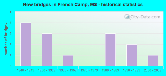
- New bridges - historical statistics
- 41940-1949
- 31950-1959
- 11960-1969
- 31980-1989
- 21990-1999
- 12000-2009

- Bridge Condition - Deck
- 40.0%Very good
- 20.0%Good
- 40.0%Satisfactory

- Bridge Condition - Superstructure
- 40.0%Very good
- 20.0%Good
- 40.0%Satisfactory

- Bridge Condition - Substructure
- 20.0%Very good
- 60.0%Good
- 20.0%Satisfactory

- Bridge Condition - Channel
- 7.1%Very good
- 42.9%Good
- 50.0%Satisfactory

- Bridge Condition - Culverts
- 11.1%Very good
- 55.6%Good
- 33.3%Satisfactory
Find on map >> Show street view
Structure Number: 31004070100177, Location: 3.0 MI W NATCHEZ TRACE (Lat: 33.307003, Lng: -89.450294), Route carried "on" structure: State highway 407, Year Built: 1982, Status: Open, Structure Length: 1.25m (4.10ft), Average Daily Traffic: 570 (year 2020), Truck Traffic: 11%, Average Future Daily Traffic: 570 (year 2040), Design Load: HS 20, Features Intersected: STREAM
Minimum Vertical Clearance: 30+ m (98+ ft), Kilometerpoint: 12.215, Lanes on structure: 2, Owner: State Highway Agency, Approaching Roadway Width: 10.4m (34.1ft), Material/Design: Concrete, Design/Construction: Culvert, Number Of Spans In Main Unit: 2, Length of Maximum Span: 6.1m (20.0ft)
Condition: Channel: Satisfactory, Culverts: Good, Operating Rating: 61.7 metric tons, Method Used To Determine Operating Rating: Load Factor (LF), Inventory Rating: 37.0 metric tons, Method Used To Determine Inventory Rating: Load Factor (LF), Structural Evaluation: Better than present minimum criteria, Waterway Adequacy: Equal to present desirable criteria, Approach Roadway Alignment: Equal to present desirable criteria, Designated Inspection Frequency: Every 24 months, Inspection Date: January 2022
Find on map >> Show street view
Structure Number: 31004110040077, Location: 4.9 MI S SR 407 (Lat: 33.138600, Lng: -89.352203), Route carried "on" structure: State highway 411, Year Built: 1986, Status: Open, Structure Length: 2.10m (6.89ft), Average Daily Traffic: 30 (year 2020), Truck Traffic: 6%, Average Future Daily Traffic: 30 (year 2040), Design Load: HS 20, Features Intersected: CREEK
Minimum Vertical Clearance: 30+ m (98+ ft), Kilometerpoint: 13.501, Lanes on structure: 2, Owner: State Highway Agency, Approaching Roadway Width: 8.5m (27.9ft), Material/Design: Concrete, Design/Construction: Channel Beam, Number Of Spans In Main Unit: 1, Number Of Approach Spans: 2, Length of Maximum Span: 9.4m (30.8ft), Curb-To-Curb Width: 8.5m (27.9ft), Out-to-Out Width: 9.3m (30.5ft)
Condition: Deck: Good, Superstructure: Good, Substructure: Very good, Channel: Good, Operating Rating: 74.4 metric tons, Method Used To Determine Operating Rating: Load Factor (LF), Inventory Rating: 44.7 metric tons, Method Used To Determine Inventory Rating: Load Factor (LF), Structural Evaluation: Better than present minimum criteria, Deck Geometry: Better than present minimum criteria, Waterway Adequacy: Equal to present desirable criteria, Approach Roadway Alignment: Equal to present desirable criteria, Designated Inspection Frequency: Every 24 months, Inspection Date: May 2021, Deck Structure Type: Concrete Precast Panels
Find on map >> Show street view
Structure Number: 31004130100055, Location: 4.6 MI N SR 12 (Lat: 33.297389, Lng: -89.363100), Route carried "on" structure: State highway 413, Year Built: 1952, Status: Open, Structure Length: 0.88m (2.89ft), Average Daily Traffic: 970 (year 2020), Truck Traffic: 11%, Average Future Daily Traffic: 970 (year 2040), Design Load: HS 20, Features Intersected: OLY CREEK
Minimum Vertical Clearance: 30+ m (98+ ft), Kilometerpoint: 8.867, Lanes on structure: 2, Owner: State Highway Agency, Approaching Roadway Width: 9.1m (29.9ft), Material/Design: Concrete, Design/Construction: Culvert, Number Of Spans In Main Unit: 2, Length of Maximum Span: 4.3m (14.1ft)
Condition: Channel: Good, Culverts: Good, Operating Rating: 44.1 metric tons, Method Used To Determine Operating Rating: Allowable Stress (AS), Inventory Rating: 32.4 metric tons, Method Used To Determine Inventory Rating: Allowable Stress (AS), Structural Evaluation: Better than present minimum criteria, Waterway Adequacy: Equal to present desirable criteria, Approach Roadway Alignment: Equal to present desirable criteria, Designated Inspection Frequency: Every 24 months, Inspection Date: January 2022
Find on map >> Show street view
Structure Number: 31004130100075, Location: 0.4 MI E NATCHEZ TRACE (Lat: 33.293111, Lng: -89.396231), Route carried "on" structure: State highway 413, Year Built: 1952, Status: Open, Structure Length: 0.87m (2.85ft), Average Daily Traffic: 1,000 (year 2020), Truck Traffic: 11%, Average Future Daily Traffic: 1,000 (year 2040), Design Load: HS 20, Features Intersected: UNNAMED CREEK
Minimum Vertical Clearance: 30+ m (98+ ft), Kilometerpoint: 12.085, Lanes on structure: 2, Owner: State Highway Agency, Approaching Roadway Width: 9.1m (29.9ft), Skew: 3 degrees, Material/Design: Concrete, Design/Construction: Culvert, Number Of Spans In Main Unit: 2, Length of Maximum Span: 3.7m (12.1ft)
Condition: Channel: Satisfactory, Culverts: Good, Operating Rating: 44.1 metric tons, Method Used To Determine Operating Rating: Allowable Stress (AS), Inventory Rating: 32.4 metric tons, Method Used To Determine Inventory Rating: Allowable Stress (AS), Structural Evaluation: Better than present minimum criteria, Waterway Adequacy: Equal to present minimum criteria, Approach Roadway Alignment: Equal to present desirable criteria, Designated Inspection Frequency: Every 24 months, Inspection Date: January 2022
Find on map >> Show street view
Structure Number: 31004130100078, Location: 0.1 MI E NATCHEZ TRACE (Lat: 33.293239, Lng: -89.402350), Route carried "on" structure: State highway 413, Year Built: 1948, Status: Open, Structure Length: 1.10m (3.61ft), Average Daily Traffic: 1,000 (year 2020), Truck Traffic: 11%, Average Future Daily Traffic: 1,000 (year 2040), Design Load: HS 20, Features Intersected: UNNAMED CREEK
Minimum Vertical Clearance: 30+ m (98+ ft), Kilometerpoint: 12.654, Lanes on structure: 2, Owner: State Highway Agency, Approaching Roadway Width: 9.1m (29.9ft), Skew: 3 degrees, Material/Design: Concrete, Design/Construction: Culvert, Number Of Spans In Main Unit: 3, Length of Maximum Span: 3.0m (9.8ft)
Condition: Channel: Satisfactory, Culverts: Good, Operating Rating: 44.1 metric tons, Method Used To Determine Operating Rating: Allowable Stress (AS), Inventory Rating: 32.4 metric tons, Method Used To Determine Inventory Rating: Allowable Stress (AS), Structural Evaluation: Better than present minimum criteria, Waterway Adequacy: Equal to present minimum criteria, Approach Roadway Alignment: Equal to present desirable criteria, Designated Inspection Frequency: Every 24 months, Inspection Date: January 2022
Find on map >> Show street view
Structure Number: 31004130100082, Location: 0.4 MI N SR 407 (Lat: 33.297169, Lng: -89.403539), Route carried "on" structure: State highway 413, Year Built: 1985, Status: Open, Structure Length: 4.73m (15.52ft), Average Daily Traffic: 670 (year 2020), Truck Traffic: 11%, Average Future Daily Traffic: 670 (year 2040), Design Load: HS 20, Features Intersected: POPLAR CREEK
Minimum Vertical Clearance: 30+ m (98+ ft), Kilometerpoint: 13.399, Lanes on structure: 2, Owner: State Highway Agency, Approaching Roadway Width: 11.0m (36.1ft), Material/Design: Concrete, Design/Construction: Channel Beam, Number Of Spans In Main Unit: 5, Length of Maximum Span: 9.4m (30.8ft), Curb-To-Curb Width: 8.5m (27.9ft), Out-to-Out Width: 9.3m (30.5ft)
Condition: Deck: Very good, Superstructure: Very good, Substructure: Good, Channel: Good, Operating Rating: 83.9 metric tons, Method Used To Determine Operating Rating: Load Factor (LF), Inventory Rating: 50.3 metric tons, Method Used To Determine Inventory Rating: Load Factor (LF), Structural Evaluation: Better than present minimum criteria, Deck Geometry: Somewhat better than minimum adequacy, Waterway Adequacy: Equal to present desirable criteria, Approach Roadway Alignment: Equal to present desirable criteria, Designated Inspection Frequency: Every 24 months, Inspection Date: January 2022, Deck Structure Type: Concrete Precast Panels
Find on map >> Show street view
Structure Number: 31004130100107, Location: 2.9 MI N SR 407 (Lat: 33.328050, Lng: -89.410881), Route carried "on" structure: State highway 413, Year Built: 1962, Status: Open, Structure Length: 0.91m (2.99ft), Average Daily Traffic: 670 (year 2020), Truck Traffic: 11%, Average Future Daily Traffic: 670 (year 2040), Design Load: H 15, Features Intersected: ELKINS
Minimum Vertical Clearance: 30+ m (98+ ft), Kilometerpoint: 17.355, Lanes on structure: 2, Owner: State Highway Agency, Approaching Roadway Width: 9.1m (29.9ft), Skew: 1 degrees, Material/Design: Concrete, Design/Construction: Culvert, Number Of Spans In Main Unit: 2, Length of Maximum Span: 4.3m (14.1ft)
Condition: Channel: Satisfactory, Culverts: Good, Operating Rating: 54.0 metric tons, Method Used To Determine Operating Rating: Load Factor (LF), Inventory Rating: 32.3 metric tons, Method Used To Determine Inventory Rating: Load Factor (LF), Structural Evaluation: Better than present minimum criteria, Waterway Adequacy: Equal to present minimum criteria, Approach Roadway Alignment: Equal to present desirable criteria, Designated Inspection Frequency: Every 24 months, Inspection Date: January 2022
Find on map >> Show street view
Structure Number: 5570108P, Location: 14.2 MILES SOUTH OF MS RO (Lat: 33.296833, Lng: -89.400722), Route carried "on" structure: Federal lands road 1, Year Built: 1949, Status: Posted for load-capacity, Structure Length: 3.21m (10.53ft), Average Daily Traffic: 1,230 (year 2012), Truck Traffic: 12%, Average Future Daily Traffic: 1,353 (year 2032), Design Load: H 15, Features Intersected: POPLAR CREEK BRANCH, Facility Carried by Structure: NATCHEZ TRACE PARK
Minimum Vertical Clearance: 30+ m (98+ ft), Kilometerpoint: 291.410, Lanes on structure: 2, Owner: National Park Service, Approaching Roadway Width: 9.7m (31.8ft), Material/Design: Concrete continuous, Design/Construction: Slab, Number Of Spans In Main Unit: 3, Length of Maximum Span: 12.2m (40.0ft), Curb-To-Curb Width: 8.5m (27.9ft), Out-to-Out Width: 9.9m (32.5ft)
Condition: Deck: Satisfactory, Superstructure: Satisfactory, Substructure: Satisfactory, Channel: Satisfactory, Operating Rating: 34.5 metric tons, Method Used To Determine Operating Rating: Load Factor (LF), Inventory Rating: 20.0 metric tons, Method Used To Determine Inventory Rating: Load Factor (LF), Structural Evaluation: Somewhat better than minimum adequacy, Deck Geometry: Somewhat better than minimum adequacy, Waterway Adequacy: Equal to present desirable criteria, Approach Roadway Alignment: Equal to present desirable criteria, Designated Inspection Frequency: Every 48 months, Inspection Date: December 2018, Bridge Improvement Cost: $30,000, Roadway Improvement Cost: $3,000, Total Project Cost: $45,000 ( Estimate for 2018), Deck Structure Type: Concrete Cast-file-Place, Wearing Surface/Protective System: Wearing Surface: Bituminous
Find on map >> Show street view
Structure Number: 5570109P, Location: 14.5 MILES SOUTH OF MS RO (Lat: 33.294056, Lng: -89.402833), Route carried "on" structure: Federal lands road 1, Year Built: 1946, Status: Posted for load-capacity, Structure Length: 1.06m (3.48ft), Average Daily Traffic: 1,230 (year 2012), Truck Traffic: 12%, Average Future Daily Traffic: 1,353 (year 2032), Design Load: H 15, Features Intersected: POPLAR CREEK, Facility Carried by Structure: NATCHEZ TRACE PARK
Minimum Vertical Clearance: 30+ m (98+ ft), Kilometerpoint: 291.090, Lanes on structure: 2, Owner: National Park Service, Approaching Roadway Width: 9.7m (31.8ft), Skew: 3 degrees, Material/Design: Concrete, Design/Construction: Frame, Number Of Spans In Main Unit: 1, Length of Maximum Span: 10.6m (34.8ft), Curb-To-Curb Width: 8.5m (27.9ft), Out-to-Out Width: 9.9m (32.5ft)
Condition: Deck: Satisfactory, Superstructure: Satisfactory, Substructure: Good, Channel: Satisfactory, Operating Rating: 31.8 metric tons, Method Used To Determine Operating Rating: Load Factor (LF), Inventory Rating: 19.1 metric tons, Method Used To Determine Inventory Rating: Load Factor (LF), Structural Evaluation: Somewhat better than minimum adequacy, Deck Geometry: Somewhat better than minimum adequacy, Waterway Adequacy: Equal to present desirable criteria, Approach Roadway Alignment: Equal to present desirable criteria, Designated Inspection Frequency: Every 48 months, Inspection Date: November 2018, Bridge Improvement Cost: $87,000, Roadway Improvement Cost: $9,000, Total Project Cost: $131,000 ( Estimate for 2018), Deck Structure Type: Concrete Cast-file-Place, Wearing Surface/Protective System: Wearing Surface: Bituminous
Find on map >> Show street view
Structure Number: 5570355P, Location: 14.5 MILES NORTH OF MS RO (Lat: 33.284500, Lng: -89.406500), Route carried "on" structure: Federal lands road 1, Year Built: 1950, Status: Posted for load-capacity, Structure Length: 0.73m (2.40ft), Average Daily Traffic: 1,140 (year 2012), Truck Traffic: 11%, Average Future Daily Traffic: 1,254 (year 2032), Features Intersected: STREAM, Facility Carried by Structure: NATCHEZ TRACE PARK
Minimum Vertical Clearance: 30+ m (98+ ft), Kilometerpoint: 290.000, Lanes on structure: 2, Owner: National Park Service, Approaching Roadway Width: 9.7m (31.8ft), Skew: 4 degrees, Material/Design: Concrete, Design/Construction: Culvert, Number Of Spans In Main Unit: 2, Length of Maximum Span: 3.7m (12.1ft)
Condition: Channel: Satisfactory, Culverts: Satisfactory, Structural Evaluation: Equal to present minimum criteria, Waterway Adequacy: Equal to present desirable criteria, Approach Roadway Alignment: Equal to present desirable criteria, Designated Inspection Frequency: Every 48 months, Inspection Date: December 2018, Bridge Improvement Cost: $11,000, Roadway Improvement Cost: $1,000, Total Project Cost: $17,000 ( Estimate for 2018)
Find on map >> Show street view
Structure Number: 5570356P, Location: 15.1 MILES NORTH OF MS RO (Lat: 33.293139, Lng: -89.403361), Route carried "on" structure: Federal lands road 1, Year Built: 1949, Status: Posted for load-capacity, Structure Length: 1.05m (3.44ft), Average Daily Traffic: 1,140 (year 2012), Truck Traffic: 11%, Average Future Daily Traffic: 1,254 (year 2032), Features Intersected: STREAM, Facility Carried by Structure: NATCHEZ TRACE PARK
Minimum Vertical Clearance: 30+ m (98+ ft), Kilometerpoint: 290.960, Lanes on structure: 2, Owner: National Park Service, Approaching Roadway Width: 6.7m (22.0ft), Skew: 5 degrees, Material/Design: Concrete, Design/Construction: Culvert, Number Of Spans In Main Unit: 4, Length of Maximum Span: 2.7m (8.9ft)
Condition: Channel: Good, Culverts: Satisfactory, Operating Rating: 83.5 metric tons, Method Used To Determine Operating Rating: Load Factor (LF), Inventory Rating: 49.9 metric tons, Method Used To Determine Inventory Rating: Load Factor (LF), Structural Evaluation: Equal to present minimum criteria, Waterway Adequacy: Equal to present desirable criteria, Approach Roadway Alignment: Equal to present desirable criteria, Designated Inspection Frequency: Every 48 months, Inspection Date: November 2018, Bridge Improvement Cost: $19,000, Roadway Improvement Cost: $2,000, Total Project Cost: $29,000 ( Estimate for 2018)
Find on map >> Show street view
Structure Number: SA0400000000161, Location: SEC 3 T16N R 9E (Lat: 33.282017, Lng: -89.354400), Route carried "on" structure: County highway 255, Year Built: 2003, Status: Open, Structure Length: 0.98m (3.22ft), Average Daily Traffic: 50 (year 2013), Truck Traffic: 8%, Average Future Daily Traffic: 75 (year 2033), Design Load: HS 20+Mod, Features Intersected: BCH YOCKANOOKANY RIVER, Facility Carried by Structure: CO. ROAD 2146
Minimum Vertical Clearance: 30+ m (98+ ft), Kilometerpoint: 4.988, Lanes on structure: 2, Owner: County Highway Agency, Approaching Roadway Width: 7.9m (25.9ft), Skew: 3 degrees, Material/Design: Concrete, Design/Construction: Culvert, Number Of Spans In Main Unit: 2, Length of Maximum Span: 4.9m (16.1ft)
Condition: Channel: Very good, Culverts: Very good, Operating Rating: 53.1 metric tons, Method Used To Determine Operating Rating: Load Factor (LF) rating reported by rating factor (RF) method using MS18 loading, Inventory Rating: 31.8 metric tons, Method Used To Determine Inventory Rating: Load Factor (LF) rating reported by rating factor (RF) method using MS18 loading, Structural Evaluation: Better than present minimum criteria, Waterway Adequacy: Equal to present desirable criteria, Approach Roadway Alignment: Equal to present desirable criteria, Length Of Structure Improvement: 0.98m (3.22ft), Designated Inspection Frequency: Every 24 months, Inspection Date: April 2020, Bridge Improvement Cost: $250,000, Roadway Improvement Cost: $100,000, Total Project Cost: $350,000 ( Estimate for 2020)
Find on map >> Show street view
Structure Number: SA1000000000021, Location: SEC 23 T17N R 8E (Lat: 33.322433, Lng: -89.422019), Route carried "on" structure: County highway 188, Year Built: 1993, Status: Open, Structure Length: 4.88m (16.01ft), Average Daily Traffic: 50 (year 2021), Truck Traffic: 8%, Average Future Daily Traffic: 75 (year 2041), Design Load: HS 20, Features Intersected: ELKINS CREEK, Facility Carried by Structure: JAMES WARD ROAD
Minimum Vertical Clearance: 30+ m (98+ ft), Kilometerpoint: 1.126, Lanes on structure: 2, Owner: County Highway Agency, Approaching Roadway Width: 10.4m (34.1ft), Material/Design: Prestressed concrete, Design/Construction: Stringer/Multi-beam, Number Of Spans In Main Unit: 3, Length of Maximum Span: 24.4m (80.1ft), Curb-To-Curb Width: 7.9m (25.9ft), Out-to-Out Width: 8.8m (28.9ft)
Condition: Deck: Very good, Superstructure: Very good, Substructure: Good, Channel: Good, Operating Rating: 58.3 metric tons, Method Used To Determine Operating Rating: Load Factor (LF) rating reported by rating factor (RF) method using MS18 loading, Inventory Rating: 33.7 metric tons, Method Used To Determine Inventory Rating: Load Factor (LF) rating reported by rating factor (RF) method using MS18 loading, Structural Evaluation: Better than present minimum criteria, Deck Geometry: Equal to present minimum criteria, Waterway Adequacy: Equal to present desirable criteria, Approach Roadway Alignment: Equal to present desirable criteria, Designated Inspection Frequency: Every 24 months, Inspection Date: May 2021, Deck Structure Type: Concrete Cast-file-Place, Wearing Surface/Protective System: Wearing Surface: Gravel
Find on map >> Show street view
Structure Number: SA100000000003, Location: SEC 18 T17N R 9E (Lat: 33.329544, Lng: -89.401017), Route carried "on" structure: County highway 187, Year Built: 1993, Status: Open, Structure Length: 0.85m (2.79ft), Average Daily Traffic: 50 (year 2021), Truck Traffic: 10%, Average Future Daily Traffic: 75 (year 2041), Design Load: HS 20, Features Intersected: ELKINS CREEK, Facility Carried by Structure: WORLE ROAD
Minimum Vertical Clearance: 30+ m (98+ ft), Kilometerpoint: 0.482, Lanes on structure: 2, Owner: County Highway Agency, Approaching Roadway Width: 10.4m (34.1ft), Skew: 3 degrees, Material/Design: Concrete, Design/Construction: Culvert, Number Of Spans In Main Unit: 2, Length of Maximum Span: 4.3m (14.1ft)
Condition: Channel: Good, Culverts: Satisfactory, Operating Rating: 47.0 metric tons, Method Used To Determine Operating Rating: Load Factor (LF) rating reported by rating factor (RF) method using MS18 loading, Inventory Rating: 28.2 metric tons, Method Used To Determine Inventory Rating: Load Factor (LF) rating reported by rating factor (RF) method using MS18 loading, Structural Evaluation: Equal to present minimum criteria, Waterway Adequacy: Equal to present desirable criteria, Approach Roadway Alignment: Equal to present desirable criteria, Designated Inspection Frequency: Every 24 months, Inspection Date: May 2021, Deck Structure Type: Concrete Cast-file-Place, Wearing Surface/Protective System: Wearing Surface: Gravel