Bridge Statistics for Goodfield, Illinois (IL)
Condition, Traffic, Stress, Structural Evaluation, Project Costs
- National Bridge Inventory (NBI) Statistics
- 15Number of bridges
- 203ft / 61.7mTotal length
- $1,950,000Total costs
- 51,775Total average daily traffic
- 9,164Total average daily truck traffic
- National Bridge Inventory (NBI) Registered Bridges for Goodfield
- No street view available for this location
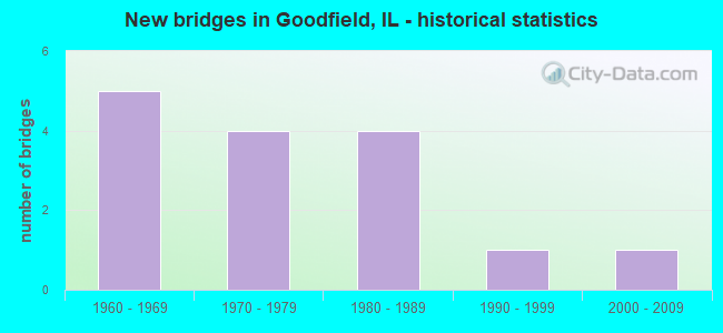
- New bridges - historical statistics
- 51960-1969
- 41970-1979
- 41980-1989
- 11990-1999
- 12000-2009


- Bridge Condition - Deck
- 9.1%Very good
- 36.4%Good
- 18.2%Satisfactory
- 27.3%Fair
- 9.1%Serious

- Bridge Condition - Superstructure
- 9.1%Very good
- 18.2%Good
- 18.2%Satisfactory
- 27.3%Fair
- 18.2%Poor
- 9.1%Serious

- Bridge Condition - Substructure
- 27.3%Very good
- 27.3%Good
- 45.5%Satisfactory

- Bridge Condition - Channel
- 38.5%Good
- 38.5%Satisfactory
- 23.1%Fair

- Bridge Condition - Culverts
- 33.3%Very good
- 66.7%Good
Find on map >> Show street view
Structure Number: 574018, Location: 5.2 MI W CARLOCK (Lat: 40.586233, Lng: -89.245317), Route carried "on" structure: County highway , Year Built: 1976, Status: Open, Structure Length: 2.90m (9.51ft), Average Daily Traffic: 25 (year 2020), Average Future Daily Traffic: 32 (year 2032), Design Load: HS 20, Features Intersected: ROCK CR, Facility Carried by Structure: TR 12
Minimum Vertical Clearance: 30+ m (98+ ft), Kilometerpoint: 0.982, Lanes on structure: 2, Owner: Town or Township Highway Agency, Approaching Roadway Width: 4.9m (16.1ft), Material/Design: Concrete continuous, Design/Construction: Slab, Number Of Spans In Main Unit: 3, Length of Maximum Span: 10.8m (35.4ft), Curb-To-Curb Width: 7.3m (24.0ft), Out-to-Out Width: 7.9m (25.9ft)
Condition: Deck: Very good, Superstructure: Very good, Substructure: Very good, Channel: Good, Operating Rating: 52.5 metric tons, Method Used To Determine Operating Rating: Load Factor (LF) rating reported by rating factor (RF) method using MS18 loading, Inventory Rating: 31.4 metric tons, Method Used To Determine Inventory Rating: Load Factor (LF) rating reported by rating factor (RF) method using MS18 loading, Structural Evaluation: Better than present minimum criteria, Deck Geometry: Equal to present minimum criteria, Waterway Adequacy: Equal to present desirable criteria, Approach Roadway Alignment: Equal to present desirable criteria, Designated Inspection Frequency: Every 48 months, Inspection Date: March 2018, Deck Structure Type: Concrete Cast-file-Place
Find on map >> Show street view
Structure Number: 57402, Location: 6.2 MI WSW CARLOCK (Lat: 40.561353, Lng: -89.240083), Route carried "on" structure: County highway , Year Built: 1978, Status: Open, Structure Length: 0.67m (2.20ft), Average Daily Traffic: 75 (year 2020), Average Future Daily Traffic: 88 (year 2032), Design Load: HS 20, Features Intersected: FUNKS CREEK, Facility Carried by Structure: TR 20
Minimum Vertical Clearance: 30+ m (98+ ft), Kilometerpoint: 2.092, Lanes on structure: 2, Owner: Town or Township Highway Agency, Approaching Roadway Width: 7.9m (25.9ft), Material/Design: Concrete continuous, Design/Construction: Culvert, Number Of Spans In Main Unit: 2, Length of Maximum Span: 3.0m (9.8ft), Curb-To-Curb Width: 7.9m (25.9ft), Out-to-Out Width: 13.4m (44.0ft)
Condition: Channel: Fair, Culverts: Good, Operating Rating: 44.4 metric tons, Method Used To Determine Operating Rating: Assigned rating based on Load Factor Design (LFD) reported by rating factor (RF) using MS18 loading, Inventory Rating: 32.4 metric tons, Method Used To Determine Inventory Rating: Assigned rating based on Load Factor Design (LFD) reported by rating factor (RF) using MS18 loading, Structural Evaluation: Better than present minimum criteria, Deck Geometry: Equal to present minimum criteria, Waterway Adequacy: Equal to present desirable criteria, Approach Roadway Alignment: Equal to present desirable criteria, Designated Inspection Frequency: Every 48 months, Inspection Date: March 2020
Find on map >> Show street view
Structure Number: 574022, Location: 7.0 WSW CARLOCK (Lat: 40.564328, Lng: -89.259100), Route carried "on" structure: County highway , Year Built: 1980, Status: Open, Structure Length: 1.31m (4.30ft), Average Daily Traffic: 200 (year 2020), Truck Traffic: 16%, Average Future Daily Traffic: 251 (year 2032), Design Load: HS 20, Features Intersected: FUNKS CREEK, Facility Carried by Structure: TR 173
Minimum Vertical Clearance: 30+ m (98+ ft), Kilometerpoint: 0.595, Lanes on structure: 2, Owner: Town or Township Highway Agency, Approaching Roadway Width: 6.7m (22.0ft), Skew: 2 degrees, Material/Design: Concrete continuous, Design/Construction: Culvert, Number Of Spans In Main Unit: 3, Length of Maximum Span: 4.9m (16.1ft)
Condition: Channel: Satisfactory, Culverts: Very good, Operating Rating: 44.1 metric tons, Method Used To Determine Operating Rating: Assigned rating based on Load Factor Design (LFD) reported by rating factor (RF) using MS18 loading, Inventory Rating: 32.4 metric tons, Method Used To Determine Inventory Rating: Assigned rating based on Load Factor Design (LFD) reported by rating factor (RF) using MS18 loading, Structural Evaluation: Equal to present desirable criteria, Waterway Adequacy: Equal to present minimum criteria, Approach Roadway Alignment: Equal to present desirable criteria, Designated Inspection Frequency: Every 48 months, Inspection Date: March 2020
Find on map >> Show street view
Structure Number: 903065, Location: S.CTR-25-T25NR2W (Lat: 40.586764, Lng: -89.278672), Route carried "on" structure: County highway , Year Built: 1964, Status: Open, Structure Length: 7.07m (23.20ft), Average Daily Traffic: 225 (year 2018), Truck Traffic: 9%, Average Future Daily Traffic: 269 (year 2032), Design Load: HS 15, Features Intersected: MACKINAW RIVER, Facility Carried by Structure: RAGAR RD - TR 67
Minimum Vertical Clearance: 30+ m (98+ ft), Kilometerpoint: 2.012, Lanes on structure: 2, Owner: Town or Township Highway Agency, Approaching Roadway Width: 5.5m (18.0ft), Material/Design: Steel continuous, Design/Construction: Stringer/Multi-beam, Number Of Spans In Main Unit: 3, Length of Maximum Span: 30.5m (100.1ft), Curb-To-Curb Width: 7.9m (25.9ft), Out-to-Out Width: 9.1m (29.9ft)
Condition: Deck: Good, Superstructure: Satisfactory, Substructure: Good, Channel: Good, Operating Rating: 49.6 metric tons, Method Used To Determine Operating Rating: Load Factor (LF) rating reported by rating factor (RF) method using MS18 loading, Inventory Rating: 29.8 metric tons, Method Used To Determine Inventory Rating: Load Factor (LF) rating reported by rating factor (RF) method using MS18 loading, Structural Evaluation: Equal to present minimum criteria, Deck Geometry: Somewhat better than minimum adequacy, Waterway Adequacy: Somewhat better than minimum adequacy, Approach Roadway Alignment: High priority of corrective action, Designated Inspection Frequency: Every 24 months, Inspection Date: January 2022, Deck Structure Type: Concrete Cast-file-Place
Find on map >> Show street view
Structure Number: 903195, Location: CTR-36-T25NR2W (Lat: 40.579047, Lng: -89.279964), Route carried "on" structure: County highway , Year Built: 1985, Status: Open, Structure Length: 2.04m (6.69ft), Average Daily Traffic: 100 (year 2018), Truck Traffic: 1%, Average Future Daily Traffic: 134 (year 2032), Design Load: HS 20, Features Intersected: ROCK CREEK, Facility Carried by Structure: KING RD-TR 338
Minimum Vertical Clearance: 30+ m (98+ ft), Kilometerpoint: 1.835, Lanes on structure: 2, Owner: Town or Township Highway Agency, Approaching Roadway Width: 7.3m (24.0ft), Material/Design: Prestressed concrete, Design/Construction: Box Beam or Girders - Multiple, Number Of Spans In Main Unit: 1, Length of Maximum Span: 19.5m (64.0ft), Curb-To-Curb Width: 7.9m (25.9ft), Out-to-Out Width: 7.9m (25.9ft)
Condition: Deck: Fair, Superstructure: Fair, Substructure: Good, Channel: Satisfactory, Operating Rating: 44.4 metric tons, Method Used To Determine Operating Rating: Assigned rating based on Load Factor Design (LFD) reported by rating factor (RF) using MS18 loading, Inventory Rating: 32.4 metric tons, Method Used To Determine Inventory Rating: Assigned rating based on Load Factor Design (LFD) reported by rating factor (RF) using MS18 loading, Structural Evaluation: Somewhat better than minimum adequacy, Deck Geometry: Equal to present minimum criteria, Waterway Adequacy: Somewhat better than minimum adequacy, Approach Roadway Alignment: Equal to present minimum criteria, Designated Inspection Frequency: Every 24 months, Inspection Date: January 2022, Deck Structure Type: Concrete Precast Panels
Find on map >> Show street view
Structure Number: 903197, Location: SW-36-T25NR2W (Lat: 40.575178, Lng: -89.282458), Route carried "on" structure: County highway , Year Built: 1985, Status: Open, Structure Length: 1.55m (5.09ft), Average Daily Traffic: 100 (year 2018), Truck Traffic: 1%, Average Future Daily Traffic: 134 (year 2032), Design Load: HS 20, Features Intersected: HOLLANDS CR, Facility Carried by Structure: KING RD - TR 338
Minimum Vertical Clearance: 30+ m (98+ ft), Kilometerpoint: 2.333, Lanes on structure: 2, Owner: Town or Township Highway Agency, Approaching Roadway Width: 8.5m (27.9ft), Skew: 2 degrees, Material/Design: Prestressed concrete, Design/Construction: Box Beam or Girders - Multiple, Number Of Spans In Main Unit: 1, Length of Maximum Span: 14.9m (48.9ft), Curb-To-Curb Width: 8.6m (28.2ft), Out-to-Out Width: 8.6m (28.2ft)
Condition: Deck: Fair, Superstructure: Fair, Substructure: Good, Channel: Good, Operating Rating: 44.4 metric tons, Method Used To Determine Operating Rating: Assigned rating based on Load Factor Design (LFD) reported by rating factor (RF) using MS18 loading, Inventory Rating: 32.4 metric tons, Method Used To Determine Inventory Rating: Assigned rating based on Load Factor Design (LFD) reported by rating factor (RF) using MS18 loading, Structural Evaluation: Somewhat better than minimum adequacy, Deck Geometry: Better than present minimum criteria, Waterway Adequacy: Meets minimum limits, Approach Roadway Alignment: Equal to present desirable criteria, Designated Inspection Frequency: Every 24 months, Inspection Date: January 2021, Deck Structure Type: Concrete Precast Panels
Find on map >> Show street view
Structure Number: 903214, Location: N.CTR-1-T24NR2W (Lat: 40.572556, Lng: -89.275197), Route carried "on" structure: County highway , Year Built: 1993, Status: Open, Structure Length: 1.93m (6.33ft), Average Daily Traffic: 75 (year 2018), Average Future Daily Traffic: 81 (year 2032), Design Load: HS 20, Features Intersected: FUNKS BRANCH, Facility Carried by Structure: TR 77
Minimum Vertical Clearance: 30+ m (98+ ft), Kilometerpoint: 0.660, Lanes on structure: 1, Owner: Town or Township Highway Agency, Approaching Roadway Width: 5.5m (18.0ft), Material/Design: Prestressed concrete, Design/Construction: Box Beam or Girders - Multiple, Number Of Spans In Main Unit: 1, Length of Maximum Span: 18.5m (60.7ft), Curb-To-Curb Width: 8.2m (26.9ft), Out-to-Out Width: 8.2m (26.9ft)
Condition: Deck: Good, Superstructure: Good, Substructure: Very good, Channel: Satisfactory, Operating Rating: 44.1 metric tons, Method Used To Determine Operating Rating: Assigned rating based on Load Factor Design (LFD) reported by rating factor (RF) using MS18 loading, Inventory Rating: 32.4 metric tons, Method Used To Determine Inventory Rating: Assigned rating based on Load Factor Design (LFD) reported by rating factor (RF) using MS18 loading, Structural Evaluation: Better than present minimum criteria, Deck Geometry: Equal to present minimum criteria, Waterway Adequacy: Equal to present desirable criteria, Approach Roadway Alignment: Equal to present desirable criteria, Designated Inspection Frequency: Every 48 months, Inspection Date: January 2020, Deck Structure Type: Concrete Precast Panels
Find on map >> Show street view
Structure Number: 90323, Location: NW-23-T25NR2W (Lat: 40.615639, Lng: -89.304692), Route carried "on" structure: County highway , Year Built: 2001, Status: Open, Structure Length: 2.12m (6.96ft), Average Daily Traffic: 675 (year 2018), Truck Traffic: 4%, Average Future Daily Traffic: 591 (year 2032), Design Load: HS 20, Features Intersected: ALLOWAY CREEK, Facility Carried by Structure: TR 47
Minimum Vertical Clearance: 30+ m (98+ ft), Kilometerpoint: 1.996, Lanes on structure: 2, Owner: Town or Township Highway Agency, Approaching Roadway Width: 6.7m (22.0ft), Skew: 1 degrees, Material/Design: Prestressed concrete, Design/Construction: Box Beam or Girders - Multiple, Number Of Spans In Main Unit: 1, Length of Maximum Span: 20.4m (66.9ft), Curb-To-Curb Width: 8.2m (26.9ft), Out-to-Out Width: 8.2m (26.9ft)
Condition: Deck: Good, Superstructure: Good, Substructure: Very good, Channel: Good, Operating Rating: 44.1 metric tons, Method Used To Determine Operating Rating: Assigned rating based on Load Factor Design (LFD) reported by rating factor (RF) using MS18 loading, Inventory Rating: 32.4 metric tons, Method Used To Determine Inventory Rating: Assigned rating based on Load Factor Design (LFD) reported by rating factor (RF) using MS18 loading, Structural Evaluation: Better than present minimum criteria, Deck Geometry: Somewhat better than minimum adequacy, Waterway Adequacy: Superior to present desirable criteria, Approach Roadway Alignment: Equal to present desirable criteria, Designated Inspection Frequency: Every 48 months, Inspection Date: December 2018, Deck Structure Type: Concrete Precast Panels, Wearing Surface/Protective System: Wearing Surface: Bituminous, Membrane: Built-up
Find on map >> Show street view
Structure Number: 1020002, Location: 1.26 MI E OF ILL 117 (Lat: 40.614944, Lng: -89.253122), Route carried "on" structure: Interstate 74, Year Built: 1964, Year Reconstructed: 1998, Status: Open, Structure Length: 12.86m (42.19ft), Average Daily Traffic: 13,450 (year 2021), Truck Traffic: 19%, Average Future Daily Traffic: 14,397 (year 2032), Design Load: HS 20+Mod, Features Intersected: MACKINAW RIVER
Minimum Vertical Clearance: 30+ m (98+ ft), Kilometerpoint: 185.407, Lanes on structure: 2, Base Highway Network: Yes, Owner: State Highway Agency, Approaching Roadway Width: 11.6m (38.1ft), Material/Design: Steel continuous, Design/Construction: Stringer/Multi-beam, Number Of Spans In Main Unit: 4, Length of Maximum Span: 35.7m (117.1ft), Curb-To-Curb Width: 11.6m (38.1ft), Out-to-Out Width: 12.6m (41.3ft)
Condition: Deck: Good, Superstructure: Serious, Substructure: Satisfactory, Channel: Fair, Operating Rating: 63.5 metric tons, Method Used To Determine Operating Rating: Load Factor (LF) rating reported by rating factor (RF) method using MS18 loading, Inventory Rating: 37.9 metric tons, Method Used To Determine Inventory Rating: Load Factor (LF) rating reported by rating factor (RF) method using MS18 loading, Structural Evaluation: High priority of corrective action, Deck Geometry: Equal to present minimum criteria, Waterway Adequacy: Superior to present desirable criteria, Approach Roadway Alignment: Equal to present desirable criteria, Length Of Structure Improvement: 14.02m (46.00ft), Designated Inspection Frequency: Every 12 months, Underwater Inspection Frequency: Every 12 months, Other Special Inspection Frequency: Every 6 months, Inspection Date: August 2021, Underwater Inspection Date: August 2021, Other Special Inspection Date: August 2021, Bridge Improvement Cost: $1,300,000, Roadway Improvement Cost: $130,000, Total Project Cost: $1,950,000, Deck Structure Type: Concrete Cast-file-Place, Wearing Surface/Protective System: Deck Protection: Epoxy Coated Reinforcing
Find on map >> Show street view
Structure Number: 1020012, Location: JCT I-74 & ILL 117 (Lat: 40.622600, Lng: -89.274831), Route carried "on" structure: State highway 117, Year Built: 1964, Year Reconstructed: 1998, Status: Open, Structure Length: 6.92m (22.70ft), Average Daily Traffic: 5,400 (year 2021), Truck Traffic: 16%, Average Future Daily Traffic: 5,825 (year 2032), Design Load: HS 20, Features Intersected: I-74
Minimum Vertical Clearance: 30+ m (98+ ft), Kilometerpoint: 0.032, Lanes on structure: 2, Lanes under structure: 4, Base Highway Network: Yes, Owner: State Highway Agency, Approaching Roadway Width: 12.2m (40.0ft), Skew: 1 degrees, Material/Design: Steel continuous, Design/Construction: Stringer/Multi-beam, Number Of Spans In Main Unit: 4, Length of Maximum Span: 21.0m (68.9ft), Curb-To-Curb Width: 12.2m (40.0ft), Out-to-Out Width: 13.2m (43.3ft)
Condition: Deck: Satisfactory, Superstructure: Fair, Substructure: Satisfactory, Operating Rating: 64.8 metric tons, Method Used To Determine Operating Rating: Load Factor (LF) rating reported by rating factor (RF) method using MS18 loading, Inventory Rating: 38.9 metric tons, Method Used To Determine Inventory Rating: Load Factor (LF) rating reported by rating factor (RF) method using MS18 loading, Structural Evaluation: Somewhat better than minimum adequacy, Deck Geometry: Somewhat better than minimum adequacy, Underclear: Somewhat better than minimum adequacy, Approach Roadway Alignment: Equal to present minimum criteria, Designated Inspection Frequency: Every 24 months, Inspection Date: July 2020, Deck Structure Type: Concrete Cast-file-Place, Wearing Surface/Protective System: Deck Protection: Epoxy Coated Reinforcing
Find on map >> Show street view
Structure Number: 1020043, Location: 1.8 MI E OF ILL 117 (Lat: 40.623744, Lng: -89.241778), Route carried "on" structure: US 150, Year Built: 1985, Status: Open, Structure Length: 15.48m (50.79ft), Average Daily Traffic: 2,900 (year 2021), Truck Traffic: 12%, Average Future Daily Traffic: 2,528 (year 2032), Design Load: HS 20, Features Intersected: MACKINAW RIVER
Minimum Vertical Clearance: 30+ m (98+ ft), Kilometerpoint: 184.587, Lanes on structure: 2, Owner: State Highway Agency, Approaching Roadway Width: 10.4m (34.1ft), Skew: 1 degrees, Material/Design: Prestressed concrete continuous, Design/Construction: Stringer/Multi-beam, Number Of Spans In Main Unit: 7, Length of Maximum Span: 28.0m (91.9ft), Curb-To-Curb Width: 9.8m (32.2ft), Out-to-Out Width: 10.7m (35.1ft)
Condition: Deck: Serious, Superstructure: Poor, Substructure: Satisfactory, Channel: Fair, Operating Rating: 59.9 metric tons, Method Used To Determine Operating Rating: Load Factor (LF) rating reported by rating factor (RF) method using MS18 loading, Inventory Rating: 36.0 metric tons, Method Used To Determine Inventory Rating: Load Factor (LF) rating reported by rating factor (RF) method using MS18 loading, Structural Evaluation: Meets minimum limits, Deck Geometry: Meets minimum limits, Waterway Adequacy: Equal to present desirable criteria, Approach Roadway Alignment: Equal to present desirable criteria, Designated Inspection Frequency: Every 12 months, Inspection Date: April 2021, Deck Structure Type: Concrete Cast-file-Place, Wearing Surface/Protective System: Deck Protection: Epoxy Coated Reinforcing
Find on map >> Show street view
Structure Number: 1023069, Location: 2.2 MI N E GOODFIELD (Lat: 40.649483, Lng: -89.227750), Route carried "on" structure: County highway , Year Built: 1966, Status: Open, Structure Length: 2.96m (9.71ft), Average Daily Traffic: 50 (year 2020), Average Future Daily Traffic: 55 (year 2032), Design Load: HS 15, Features Intersected: WALNUT CR, Facility Carried by Structure: TR 136
Minimum Vertical Clearance: 30+ m (98+ ft), Kilometerpoint: 3.025, Lanes on structure: 2, Owner: Town or Township Highway Agency, Approaching Roadway Width: 6.1m (20.0ft), Skew: 1 degrees, Material/Design: Concrete continuous, Design/Construction: Slab, Number Of Spans In Main Unit: 3, Length of Maximum Span: 11.0m (36.1ft), Curb-To-Curb Width: 6.7m (22.0ft), Out-to-Out Width: 7.9m (25.9ft)
Condition: Deck: Satisfactory, Superstructure: Satisfactory, Substructure: Satisfactory, Channel: Good, Operating Rating: 36.0 metric tons, Method Used To Determine Operating Rating: Load Factor (LF) rating reported by rating factor (RF) method using MS18 loading, Inventory Rating: 21.4 metric tons, Method Used To Determine Inventory Rating: Load Factor (LF) rating reported by rating factor (RF) method using MS18 loading, Structural Evaluation: Equal to present minimum criteria, Deck Geometry: Somewhat better than minimum adequacy, Waterway Adequacy: Equal to present minimum criteria, Approach Roadway Alignment: Equal to present desirable criteria, Designated Inspection Frequency: Every 24 months, Inspection Date: June 2020, Deck Structure Type: Concrete Cast-file-Place
Find on map >> Show street view
Structure Number: 1023111, Location: 1500 EAST 525 NORTH (Lat: 40.665900, Lng: -89.252731), Route carried "on" structure: County highway , Year Built: 1974, Status: Open, Structure Length: 3.23m (10.60ft), Average Daily Traffic: 350 (year 2020), Truck Traffic: 23%, Average Future Daily Traffic: 330 (year 2032), Design Load: HS 15, Features Intersected: WALNUT CR, Facility Carried by Structure: TR.118
Minimum Vertical Clearance: 30+ m (98+ ft), Kilometerpoint: 2.961, Lanes on structure: 2, Owner: Town or Township Highway Agency, Approaching Roadway Width: 6.1m (20.0ft), Material/Design: Concrete, Design/Construction: Slab, Number Of Spans In Main Unit: 3, Length of Maximum Span: 13.7m (44.9ft), Curb-To-Curb Width: 7.3m (24.0ft), Out-to-Out Width: 8.0m (26.2ft)
Condition: Deck: Fair, Superstructure: Poor, Substructure: Satisfactory, Channel: Satisfactory, Operating Rating: 43.4 metric tons, Method Used To Determine Operating Rating: Load Factor (LF) rating reported by rating factor (RF) method using MS18 loading, Inventory Rating: 24.6 metric tons, Method Used To Determine Inventory Rating: Load Factor (LF) rating reported by rating factor (RF) method using MS18 loading, Structural Evaluation: Meets minimum limits, Deck Geometry: Somewhat better than minimum adequacy, Waterway Adequacy: Equal to present minimum criteria, Approach Roadway Alignment: Equal to present desirable criteria, Designated Inspection Frequency: Every 24 months, Inspection Date: Febuary 2021, Deck Structure Type: Concrete Precast Panels, Wearing Surface/Protective System: Wearing Surface: Gravel
Find on map >> Show street view
Structure Number: 1025004, Location: 1250 EAST 500 NORTH (Lat: 40.660922, Lng: -89.301567), Route carried "on" structure: County highway , Year Built: 1976, Status: Open, Structure Length: 0.66m (2.17ft), Average Daily Traffic: 1,250 (year 2020), Truck Traffic: 10%, Average Future Daily Traffic: 989 (year 2032), Design Load: HS 20, Features Intersected: MUD CREEK, Facility Carried by Structure: TR 231
Minimum Vertical Clearance: 30+ m (98+ ft), Kilometerpoint: 2.301, Lanes on structure: 2, Owner: Town or Township Highway Agency, Approaching Roadway Width: 4.9m (16.1ft), Material/Design: Concrete continuous, Design/Construction: Culvert, Number Of Spans In Main Unit: 2, Length of Maximum Span: 3.0m (9.8ft)
Condition: Channel: Satisfactory, Culverts: Good, Operating Rating: 40.5 metric tons, Method Used To Determine Operating Rating: Load Factor (LF) rating reported by rating factor (RF) method using MS18 loading, Inventory Rating: 24.3 metric tons, Method Used To Determine Inventory Rating: Load Factor (LF) rating reported by rating factor (RF) method using MS18 loading, Structural Evaluation: Equal to present minimum criteria, Waterway Adequacy: Equal to present desirable criteria, Approach Roadway Alignment: Equal to present desirable criteria, Designated Inspection Frequency: Every 24 months, Inspection Date: June 2020, Wearing Surface/Protective System: Wearing Surface: Gravel
Find on map >> Show street view
Structure Number: 1020012, Location: JCT I-74 & ILL 117 (Lat: 40.622369, Lng: -89.274831), Route carried "under" structure: Interstate 74, Year Built: 1964, Structure Length: 0. m, Average Daily Traffic: 26,900 (year 2021), Truck Traffic: 19%, Features Intersected: I-74, Facility Carried by Structure: ILL 117
Minimum Vertical Clearance: 5.18m (16.99ft), Kilometerpoint: 183.348, Lanes on structure: 2, Lanes under structure: 4, Material/Design: Steel continuous, Design/Construction: Stringer/Multi-beam, Length of Maximum Span: 21.0m (68.9ft)