Bridge Statistics for Grand Terrace, California (CA)
Condition, Traffic, Stress, Structural Evaluation, Project Costs
- National Bridge Inventory (NBI) Statistics
- 13Number of bridges
- 121ft / 36.6mTotal length
- 1,104,322Total average daily traffic
- 78,281Total average daily truck traffic
- National Bridge Inventory (NBI) Registered Bridges for Grand Terrace
- No street view available for this location
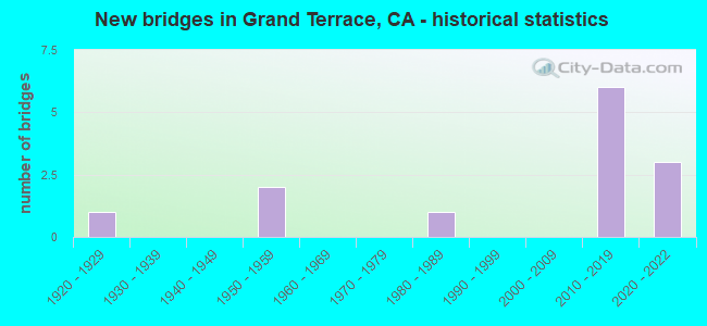
- New bridges - historical statistics
- 11920-1929
- 21950-1959
- 11980-1989
- 62010-2019
- 32020-2022


- Bridge Condition - Deck
- 83.3%Good
- 16.7%Fair

- Bridge Condition - Superstructure
- 66.7%Good
- 33.3%Fair

- Bridge Condition - Substructure
- 83.3%Good
- 16.7%Fair
Find on map >> Show street view
Structure Number: 54 0528, Location: 08-SBD-215-1.31 (Lat: 34.033808, Lng: -117.325483), Route carried "on" structure: City street R028, Year Built: 1959, Status: Open, Structure Length: 7.83m (25.69ft), Average Daily Traffic: 18,000 (year 2012), Truck Traffic: 6%, Average Future Daily Traffic: 21,495 (year 2042), Design Load: HS 20, Features Intersected: INTERSTATE 215, Facility Carried by Structure: BARTON ROAD
Minimum Vertical Clearance: 30+ m (98+ ft), Kilometerpoint: 0.000, Lanes on structure: 3, Lanes under structure: 8, Owner: State Highway Agency, Approaching Roadway Width: 13.6m (44.6ft), Skew: 4 degrees, Material/Design: Concrete continuous, Design/Construction: Tee Beam, Number Of Spans In Main Unit: 4, Length of Maximum Span: 24.4m (80.1ft), Curb or Sidewalk Widths: Left: 1.5m (4.9ft), Right: 0.0m, Curb-To-Curb Width: 13.6m (44.6ft), Out-to-Out Width: 16.1m (52.8ft)
Condition: Deck: Fair, Superstructure: Fair, Substructure: Good, Operating Rating: 76.8 metric tons, Method Used To Determine Operating Rating: Load Factor (LF), Inventory Rating: 46.0 metric tons, Method Used To Determine Inventory Rating: Load Factor (LF), Structural Evaluation: Somewhat better than minimum adequacy, Deck Geometry: Somewhat better than minimum adequacy, Underclear: High priority of corrective action, Approach Roadway Alignment: Equal to present desirable criteria, Designated Inspection Frequency: Every 24 months, Inspection Date: September 2020, Deck Structure Type: Concrete Cast-file-Place, Wearing Surface/Protective System: Wearing Surface: Bituminous
Find on map >> Show street view
Structure Number: 54 1290K, Location: 08-SBD-015-6.85-RCUC (Lat: 34.122697, Lng: -117.514806), Route carried "on" structure: Ramp Interstate 15, Year Built: 2016, Status: Open, Structure Length: 4.33m (14.21ft), Average Daily Traffic: 3,501 (year 2014), Truck Traffic: 10%, Average Future Daily Traffic: 5,800 (year 2040), Design Load: HL 93, Features Intersected: EAST AVENUE
Minimum Vertical Clearance: 30+ m (98+ ft), Kilometerpoint: 6.850, Lanes on structure: 2, Lanes under structure: 4, Base Highway Network: Yes, Owner: State Highway Agency, Approaching Roadway Width: 11.6m (38.1ft), Skew: 1 degrees, Material/Design: Concrete continuous, Design/Construction: Box Beam or Girders - Multiple, Number Of Spans In Main Unit: 2, Length of Maximum Span: 21.6m (70.9ft), Curb-To-Curb Width: 11.6m (38.1ft), Out-to-Out Width: 12.5m (41.0ft)
Condition: Deck: Good, Superstructure: Good, Substructure: Good, Operating Rating: 42.1 metric tons, Method Used To Determine Operating Rating: Assigned ratings based on Load and Resistance Factor Design (LRFD) reported by rating factor (RF) using HL93 loadings, Inventory Rating: 32.4 metric tons, Method Used To Determine Inventory Rating: Assigned ratings based on Load and Resistance Factor Design (LRFD) reported by rating factor (RF) using HL93 loadings, Structural Evaluation: Better than present minimum criteria, Deck Geometry: Superior to present desirable criteria, Underclear: Somewhat better than minimum adequacy, Approach Roadway Alignment: Equal to present desirable criteria, Designated Inspection Frequency: Every 24 months, Inspection Date: March 2021, Deck Structure Type: Concrete Cast-file-Place
Find on map >> Show street view
Structure Number: 54 1294, Location: 08-SBD-215-1.78-GRTR (Lat: 34.038703, Lng: -117.319158), Route carried "on" structure: City street R211, Year Built: 2014, Status: Open, Structure Length: 5.64m (18.50ft), Average Daily Traffic: 1,001 (year 2015), Truck Traffic: 2%, Average Future Daily Traffic: 1,200 (year 2039), Design Load: Greater than HL93, Features Intersected: INTERSTATE 215, Facility Carried by Structure: NEWPORT AVENUE
Minimum Vertical Clearance: 30+ m (98+ ft), Kilometerpoint: 0.000, Lanes on structure: 2, Lanes under structure: 8, Owner: State Highway Agency, Approaching Roadway Width: 11.5m (37.7ft), Skew: 1 degrees, Material/Design: Concrete continuous, Design/Construction: Box Beam or Girders - Multiple, Number Of Spans In Main Unit: 2, Length of Maximum Span: 28.2m (92.5ft), Curb or Sidewalk Widths: Left: 1.9m (6.2ft), Right: 1.9m (6.2ft), Curb-To-Curb Width: 11.0m (36.1ft), Out-to-Out Width: 15.5m (50.9ft)
Condition: Deck: Good, Superstructure: Good, Substructure: Good, Operating Rating: 42.1 metric tons, Method Used To Determine Operating Rating: Assigned ratings based on Load and Resistance Factor Design (LRFD) reported by rating factor (RF) using HL93 loadings, Inventory Rating: 32.4 metric tons, Method Used To Determine Inventory Rating: Assigned ratings based on Load and Resistance Factor Design (LRFD) reported by rating factor (RF) using HL93 loadings, Structural Evaluation: Better than present minimum criteria, Deck Geometry: Equal to present minimum criteria, Underclear: Equal to present minimum criteria, Approach Roadway Alignment: Equal to present desirable criteria, Designated Inspection Frequency: Every 48 months, Inspection Date: January 2022, Deck Structure Type: Concrete Cast-file-Place
Find on map >> Show street view
Structure Number: 54 1323, Location: 08-SBD-215-1.31 (Lat: 34.033667, Lng: -117.325750), Route carried "on" structure: City street R028, Year Built: 2020, Status: Open, Structure Length: 10.63m (34.88ft), Average Daily Traffic: 172,000 (year 2020), Truck Traffic: 6%, Average Future Daily Traffic: 310,651 (year 2040), Design Load: Greater than HL93, Features Intersected: INTERSTATE 215, Facility Carried by Structure: BARTON ROAD
Minimum Vertical Clearance: 30+ m (98+ ft), Kilometerpoint: 0.000, Lanes on structure: 4, Lanes under structure: 9, Owner: State Highway Agency, Approaching Roadway Width: 7.3m (24.0ft), Skew: 24 degrees, Material/Design: Prestressed concrete continuous, Design/Construction: Box Beam or Girders - Multiple, Number Of Spans In Main Unit: 3, Length of Maximum Span: 38.2m (125.3ft), Curb or Sidewalk Widths: Left: 2.4m (7.9ft), Right: 2.4m (7.9ft), Curb-To-Curb Width: 28.4m (93.2ft), Out-to-Out Width: 33.9m (111.2ft)
Condition: Deck: Good, Superstructure: Good, Substructure: Good, Operating Rating: 42.1 metric tons, Method Used To Determine Operating Rating: Assigned ratings based on Load and Resistance Factor Design (LRFD) reported by rating factor (RF) using HL93 loadings, Inventory Rating: 32.4 metric tons, Method Used To Determine Inventory Rating: Assigned ratings based on Load and Resistance Factor Design (LRFD) reported by rating factor (RF) using HL93 loadings, Structural Evaluation: Better than present minimum criteria, Deck Geometry: Superior to present desirable criteria, Underclear: Somewhat better than minimum adequacy, Approach Roadway Alignment: Equal to present desirable criteria, Designated Inspection Frequency: Every 24 months, Inspection Date: January 2022, Deck Structure Type: Concrete Cast-file-Place
Find on map >> Show street view
Structure Number: 54C0355, Location: 0.35 MI W OF RTE 215 (Lat: 34.038733, Lng: -117.327908), Route carried "on" structure: City street , Year Built: 1986, Status: Open, Structure Length: 2.80m (9.19ft), Average Daily Traffic: 400 (year 2015), Truck Traffic: 2%, Average Future Daily Traffic: 522 (year 2040), Design Load: HS 20+Mod, Features Intersected: UP RR, Facility Carried by Structure: VIVIENDA AVE
Minimum Vertical Clearance: 30+ m (98+ ft), Kilometerpoint: 0.000, Lanes on structure: 2, Owner: City or Municipal Highway Agency, Approaching Roadway Width: 9.8m (32.2ft), Skew: 1 degrees, Material/Design: Prestressed concrete, Design/Construction: Stringer/Multi-beam, Number Of Spans In Main Unit: 1, Length of Maximum Span: 27.4m (89.9ft), Curb-To-Curb Width: 9.8m (32.2ft), Out-to-Out Width: 10.8m (35.4ft)
Condition: Deck: Good, Superstructure: Good, Substructure: Good, Operating Rating: 71.6 metric tons, Method Used To Determine Operating Rating: Load and Resistance Factor Rating (LRFR) rating reported by rating factor(RF) method using HL-93 loadings, Inventory Rating: 48.3 metric tons, Method Used To Determine Inventory Rating: Load and Resistance Factor Rating (LRFR) rating reported by rating factor(RF) method using HL-93 loadings, Structural Evaluation: Better than present minimum criteria, Deck Geometry: Better than present minimum criteria, Underclear: Equal to present minimum criteria, Approach Roadway Alignment: Equal to present desirable criteria, Designated Inspection Frequency: Every 48 months, Inspection Date: July 2020, Deck Structure Type: Concrete Cast-file-Place
Find on map >> Show street view
Structure Number: 54C0379, Location: 0.25 MI WEST OF I-215 (Lat: 34.033822, Lng: -117.329833), Route carried "on" structure: City street , Year Built: 1929, Year Reconstructed: 1941, Status: Open, Structure Length: 5.36m (17.59ft), Average Daily Traffic: 10,420 (year 2015), Truck Traffic: 8%, Average Future Daily Traffic: 15,716 (year 2040), Features Intersected: UP RR, Facility Carried by Structure: BARTON RD
Minimum Vertical Clearance: 30+ m (98+ ft), Kilometerpoint: 0.000, Lanes on structure: 2, Owner: City or Municipal Highway Agency, Approaching Roadway Width: 7.9m (25.9ft), Skew: 1 degrees, Material/Design: Steel, Design/Construction: Stringer/Multi-beam, Number Of Spans In Main Unit: 5, Length of Maximum Span: 11.6m (38.1ft), Curb or Sidewalk Widths: Left: 1.1m (3.6ft), Right: 0.0m, Curb-To-Curb Width: 7.8m (25.6ft), Out-to-Out Width: 9.6m (31.5ft)
Condition: Deck: Good, Superstructure: Fair, Substructure: Fair, Operating Rating: 31.4 metric tons, Method Used To Determine Operating Rating: Load Factor (LF), Inventory Rating: 18.8 metric tons, Method Used To Determine Inventory Rating: Load Factor (LF), Structural Evaluation: Meets minimum limits, Deck Geometry: High priority of replacement, Underclear: Meets minimum limits, Approach Roadway Alignment: High priority of corrective action, Designated Inspection Frequency: Every 24 months, Critical Feature Inspection Frequency: Every 24 months, Other Special Inspection Frequency: Every 24 months, Inspection Date: July 2020, Critical Feature Inspection Date: March 2020, Other Special Inspection Date: March 2020, Deck Structure Type: Concrete Cast-file-Place, Wearing Surface/Protective System: Wearing Surface: Bituminous
Find on map >> Show street view
Structure Number: 54 0528, Location: 08-SBD-215-1.31 (Lat: 34.033808, Lng: -117.325483), Route carried "under" structure: Interstate 215, Year Built: 1959, Structure Length: 0. m, Average Daily Traffic: 153,000 (year 2013), Truck Traffic: 7%, Features Intersected: INTERSTATE 215, Facility Carried by Structure: BARTON ROAD
Minimum Vertical Clearance: 4.42m (14.50ft), Kilometerpoint: 1.310, Lanes on structure: 3, Lanes under structure: 8, Material/Design: Concrete continuous, Design/Construction: Tee Beam, Length of Maximum Span: 24.4m (80.1ft)
Find on map >> Show street view
Structure Number: 54 1294, Location: 08-SBD-215-1.78-GRTR (Lat: 34.038703, Lng: -117.319158), Route carried "under" structure: Interstate 215, Year Built: 2014, Structure Length: 0. m, Average Daily Traffic: 153,000 (year 2013), Truck Traffic: 7%, Features Intersected: INTERSTATE 215, Facility Carried by Structure: NEWPORT AVENUE
Minimum Vertical Clearance: 5.60m (18.37ft), Kilometerpoint: 1.780, Lanes on structure: 2, Lanes under structure: 8, Material/Design: Concrete continuous, Design/Construction: Box Beam or Girders - Multiple, Length of Maximum Span: 28.2m (92.5ft)
Find on map >> Show street view
Structure Number: 54 1303, Location: 08-SBD-215-0.58-GRTR (Lat: 34.026461, Lng: -117.333442), Route carried "under" structure: Interstate 215, Year Built: 2015, Structure Length: 0. m, Average Daily Traffic: 147,000 (year 2013), Truck Traffic: 7%, Features Intersected: INTERSTATE 215, Facility Carried by Structure: HIGHGROVE UP #3
Minimum Vertical Clearance: 5.03m (16.50ft), Kilometerpoint: 0.580, Lanes under structure: 6, Material/Design: Steel, Design/Construction: Truss - Thru, Length of Maximum Span: 61.0m (200.1ft)
Find on map >> Show street view
Structure Number: 54 1304, Location: 08-SBD-215-0.60-GRTR (Lat: 34.026625, Lng: -117.333219), Route carried "under" structure: Interstate 215, Year Built: 2014, Structure Length: 0. m, Average Daily Traffic: 147,000 (year 2013), Truck Traffic: 7%, Features Intersected: INTERSTATE 215, Facility Carried by Structure: BNSF RAILROAD
Minimum Vertical Clearance: 5.03m (16.50ft), Kilometerpoint: 0.600, Lanes under structure: 6, Material/Design: Steel, Design/Construction: Truss - Thru, Length of Maximum Span: 61.0m (200.1ft)
Find on map >> Show street view
Structure Number: 54 1305, Location: 08-SBD-215-0.61-GRTR (Lat: 34.026644, Lng: -117.333078), Route carried "under" structure: Interstate 215, Year Built: 2014, Structure Length: 0. m, Average Daily Traffic: 143,000 (year 2013), Truck Traffic: 9%, Features Intersected: INTERSTATE 215, Facility Carried by Structure: BNSF RAILROAD
Minimum Vertical Clearance: 5.03m (16.50ft), Kilometerpoint: 0.610, Lanes under structure: 6, Material/Design: Steel, Design/Construction: Truss - Thru, Length of Maximum Span: 61.0m (200.1ft)
Find on map >> Show street view
Structure Number: 54 1323, Location: 08-SBD-215-1.31 (Lat: 34.033667, Lng: -117.325750), Route carried "under" structure: Interstate 215, Year Built: 2020, Structure Length: 0. m, Average Daily Traffic: 153,000 (year 2013), Truck Traffic: 7%, Features Intersected: INTERSTATE 215, Facility Carried by Structure: BARTON ROAD
Minimum Vertical Clearance: 5.55m (18.21ft), Kilometerpoint: 1.310, Lanes on structure: 4, Lanes under structure: 8, Material/Design: Prestressed concrete continuous, Design/Construction: Box Beam or Girders - Multiple, Length of Maximum Span: 38.2m (125.3ft)
Find on map >> Show street view
Structure Number: 54 1323, Location: 08-SBD-215-1.31 (Lat: 34.033667, Lng: -117.325750), Route carried "under" structure: Ramp Interstate 215, Year Built: 2020, Structure Length: 0. m, Average Daily Traffic: 3,000 (year 2020), Truck Traffic: 3%, Features Intersected: INTERSTATE 215, Facility Carried by Structure: BARTON ROAD
Minimum Vertical Clearance: 5.89m (19.32ft), Kilometerpoint: 1.310, Lanes on structure: 4, Lanes under structure: 1, Material/Design: Prestressed concrete continuous, Design/Construction: Box Beam or Girders - Multiple, Length of Maximum Span: 38.2m (125.3ft)