Bridge Statistics for Greenville, Delaware (DE)
Condition, Traffic, Stress, Structural Evaluation, Project Costs
- National Bridge Inventory (NBI) Statistics
- 18Number of bridges
- 112ft / 33.9mTotal length
- $2,379,000Total costs
- 155,112Total average daily traffic
- 12,091Total average daily truck traffic
- National Bridge Inventory (NBI) Registered Bridges for Greenville
- No street view available for this location
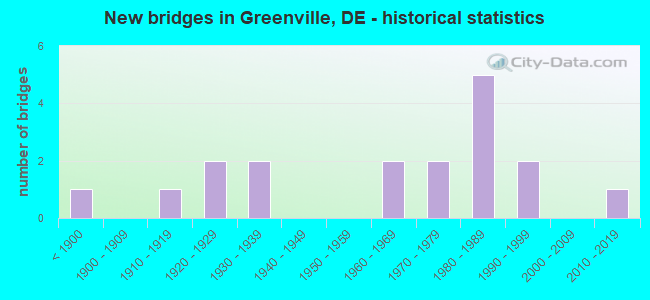
- New bridges - historical statistics
- 1Before 1900
- 11910-1919
- 21920-1929
- 21930-1939
- 21960-1969
- 21970-1979
- 51980-1989
- 21990-1999
- 12010-2019

- Reconstructed bridges - Historical Statistics
- 11970-1979
- 11980-1989
- 21990-1999
- 12000-2009


- Bridge Condition - Deck
- 22.2%Very good
- 44.4%Good
- 33.3%Satisfactory

- Bridge Condition - Superstructure
- 11.1%Very good
- 44.4%Good
- 44.4%Satisfactory

- Bridge Condition - Substructure
- 44.4%Good
- 44.4%Satisfactory
- 11.1%Poor

- Bridge Condition - Channel
- 26.7%Very good
- 33.3%Good
- 26.7%Satisfactory
- 13.3%Fair

- Bridge Condition - Culverts
- 50.0%Good
- 25.0%Satisfactory
- 25.0%Fair
Find on map >> Show street view
Structure Number: 1002 232, Location: ROCKLAND (Lat: 39.796986, Lng: -75.575075), Route carried "on" structure: County highway 232, Year Built: 1933, Year Reconstructed: 1993, Status: Open, Structure Length: 5.01m (16.44ft), Average Daily Traffic: 3,409 (year 2018), Truck Traffic: 13%, Average Future Daily Traffic: 4,277 (year 2042), Features Intersected: BRANDYWINE CREEK, Facility Carried by Structure: ROCKLAND RD
Minimum Vertical Clearance: 30.48m (100.00ft), Kilometerpoint: 3.685, Lanes on structure: 2, Owner: State Highway Agency, Approaching Roadway Width: 7.4m (24.3ft), Material/Design: Steel, Design/Construction: Stringer/Multi-beam, Number Of Spans In Main Unit: 1, Number Of Approach Spans: 1, Length of Maximum Span: 34.3m (112.5ft), Curb or Sidewalk Widths: Left: 1.6m (5.2ft), Right: 1.6m (5.2ft), Curb-To-Curb Width: 7.3m (24.0ft), Out-to-Out Width: 11.5m (37.7ft)
Condition: Deck: Good, Superstructure: Satisfactory, Substructure: Satisfactory, Channel: Very good, Operating Rating: 27.5 metric tons, Method Used To Determine Operating Rating: Load and Resistance Factor Rating (LRFR) rating reported by rating factor(RF) method using HL-93 loadings, Inventory Rating: 21.1 metric tons, Method Used To Determine Inventory Rating: Load and Resistance Factor Rating (LRFR) rating reported by rating factor(RF) method using HL-93 loadings, Structural Evaluation: Somewhat better than minimum adequacy, Deck Geometry: High priority of replacement, Waterway Adequacy: Equal to present desirable criteria, Approach Roadway Alignment: Equal to present minimum criteria, Length Of Structure Improvement: 5.00m (16.40ft), Designated Inspection Frequency: Every 24 months, Inspection Date: June 2021, Bridge Improvement Cost: $607,000, Roadway Improvement Cost: $61,000, Total Project Cost: $910,000, Deck Structure Type: Concrete Cast-file-Place, Wearing Surface/Protective System: Wearing Surface: Monolithic Concrete, Deck Protection: Epoxy Coated Reinforcing
Find on map >> Show street view
Structure Number: 1003 225, Location: E. OF GUYENCOURT (Lat: 39.816994, Lng: -75.569889), Route carried "on" structure: State highway 92, Year Built: 1990, Status: Open, Structure Length: 5.92m (19.42ft), Average Daily Traffic: 8,076 (year 2019), Truck Traffic: 7%, Average Future Daily Traffic: 10,037 (year 2042), Design Load: HS 20, Features Intersected: BRANDYWINE CREEK, Facility Carried by Structure: THOMPSON BRIDGE RD
Minimum Vertical Clearance: 30.48m (100.00ft), Kilometerpoint: 6.083, Lanes on structure: 2, Owner: State Highway Agency, Approaching Roadway Width: 8.8m (28.9ft), Skew: 1 degrees, Material/Design: Prestressed concrete, Design/Construction: Box Beam or Girders - Multiple, Number Of Spans In Main Unit: 2, Length of Maximum Span: 28.4m (93.2ft), Curb-To-Curb Width: 13.4m (44.0ft), Out-to-Out Width: 14.3m (46.9ft)
Condition: Deck: Satisfactory, Superstructure: Satisfactory, Substructure: Good, Channel: Satisfactory, Operating Rating: 71.3 metric tons, Method Used To Determine Operating Rating: Load and Resistance Factor Rating (LRFR) rating reported by rating factor(RF) method using HL-93 loadings, Inventory Rating: 54.1 metric tons, Method Used To Determine Inventory Rating: Load and Resistance Factor Rating (LRFR) rating reported by rating factor(RF) method using HL-93 loadings, Structural Evaluation: Equal to present minimum criteria, Deck Geometry: Equal to present minimum criteria, Waterway Adequacy: Equal to present desirable criteria, Approach Roadway Alignment: Equal to present desirable criteria, Length Of Structure Improvement: 6.00m (19.69ft), Designated Inspection Frequency: Every 24 months, Inspection Date: May 2020, Deck Structure Type: Concrete Cast-file-Place, Wearing Surface/Protective System: Wearing Surface: Monolithic Concrete, Deck Protection: Epoxy Coated Reinforcing
Find on map >> Show street view
Structure Number: 1008 221, Location: N/E OF CENTERVILLE (Lat: 39.835028, Lng: -75.575889), Route carried "on" structure: County highway 221, Year Built: 1960, Status: Open, Structure Length: 1.33m (4.36ft), Average Daily Traffic: 2,265 (year 2018), Truck Traffic: 13%, Average Future Daily Traffic: 2,841 (year 2042), Design Load: HS 20, Features Intersected: TRIB. TO BRANDYWINE, Facility Carried by Structure: BRANDYWINE CREEK R
Minimum Vertical Clearance: 30.48m (100.00ft), Kilometerpoint: 4.506, Lanes on structure: 2, Owner: State Highway Agency, Approaching Roadway Width: 6.4m (21.0ft), Material/Design: Steel, Design/Construction: Stringer/Multi-beam, Number Of Spans In Main Unit: 1, Length of Maximum Span: 12.5m (41.0ft), Curb-To-Curb Width: 8.5m (27.9ft), Out-to-Out Width: 9.1m (29.9ft)
Condition: Deck: Good, Superstructure: Good, Substructure: Satisfactory, Channel: Satisfactory, Operating Rating: 51.2 metric tons, Method Used To Determine Operating Rating: Load and Resistance Factor Rating (LRFR) rating reported by rating factor(RF) method using HL-93 loadings, Inventory Rating: 39.2 metric tons, Method Used To Determine Inventory Rating: Load and Resistance Factor Rating (LRFR) rating reported by rating factor(RF) method using HL-93 loadings, Structural Evaluation: Equal to present minimum criteria, Deck Geometry: Meets minimum limits, Waterway Adequacy: Better than present minimum criteria, Approach Roadway Alignment: Equal to present minimum criteria, Designated Inspection Frequency: Every 24 months, Inspection Date: March 2020, Deck Structure Type: Concrete Cast-file-Place, Wearing Surface/Protective System: Wearing Surface: Bituminous
Find on map >> Show street view
Structure Number: 1009 221, Location: N. OF BRANDYWINE CREEK SP (Lat: 39.837733, Lng: -75.579103), Route carried "on" structure: County highway 221, Year Built: 1839, Year Reconstructed: 2002, Status: Open, Structure Length: 4.36m (14.30ft), Average Daily Traffic: 2,348 (year 2019), Truck Traffic: 10%, Average Future Daily Traffic: 2,946 (year 2043), Design Load: HS 20+Mod, Features Intersected: BRANDYWINE CREEK, Facility Carried by Structure: SMITH BRIDGE RD
Minimum Vertical Clearance: 3.90m (12.80ft), Kilometerpoint: 4.040, Lanes on structure: 1, Owner: State Highway Agency, Approaching Roadway Width: 7.0m (23.0ft), Material/Design: Steel continuous, Design/Construction: Stringer/Multi-beam, Number Of Spans In Main Unit: 3, Length of Maximum Span: 13.7m (44.9ft), Curb-To-Curb Width: 4.6m (15.1ft), Out-to-Out Width: 5.2m (17.1ft)
Condition: Deck: Good, Superstructure: Satisfactory, Substructure: Good, Channel: Good, Operating Rating: 80.4 metric tons, Method Used To Determine Operating Rating: Load and Resistance Factor Rating (LRFR) rating reported by rating factor(RF) method using HL-93 loadings, Inventory Rating: 61.9 metric tons, Method Used To Determine Inventory Rating: Load and Resistance Factor Rating (LRFR) rating reported by rating factor(RF) method using HL-93 loadings, Structural Evaluation: Equal to present minimum criteria, Deck Geometry: High priority of replacement, Waterway Adequacy: Equal to present desirable criteria, Approach Roadway Alignment: Meets minimum limits, Length Of Structure Improvement: 4.36m (14.30ft), Designated Inspection Frequency: Every 24 months, Inspection Date: Febuary 2021, Bridge Improvement Cost: $243,000, Roadway Improvement Cost: $24,000, Total Project Cost: $365,000, Deck Structure Type: Wood or Timber, Wearing Surface/Protective System: Wearing Surface: Wood or Timber
Find on map >> Show street view
Structure Number: 1014 221, Location: N/E OF CENTERVILLE (Lat: 39.837253, Lng: -75.573325), Route carried "on" structure: County highway 221, Year Built: 1962, Status: Open, Structure Length: 0.96m (3.15ft), Average Daily Traffic: 2,265 (year 2018), Truck Traffic: 13%, Average Future Daily Traffic: 2,841 (year 2042), Design Load: HS 20, Features Intersected: TRIB. TO BRANDYWINE CRK, Facility Carried by Structure: BEAVER DAM RD.
Minimum Vertical Clearance: 30.48m (100.00ft), Kilometerpoint: 4.860, Lanes on structure: 2, Owner: State Highway Agency, Approaching Roadway Width: 7.3m (24.0ft), Material/Design: Concrete, Design/Construction: Culvert, Number Of Spans In Main Unit: 3, Length of Maximum Span: 3.0m (9.8ft), Curb-To-Curb Width: 8.5m (27.9ft), Out-to-Out Width: 10.1m (33.1ft)
Condition: Channel: Fair, Culverts: Good, Operating Rating: 40.5 metric tons, Method Used To Determine Operating Rating: Load and Resistance Factor Rating (LRFR) rating reported by rating factor(RF) method using HL-93 loadings, Inventory Rating: 31.4 metric tons, Method Used To Determine Inventory Rating: Load and Resistance Factor Rating (LRFR) rating reported by rating factor(RF) method using HL-93 loadings, Structural Evaluation: Better than present minimum criteria, Deck Geometry: Meets minimum limits, Waterway Adequacy: Better than present minimum criteria, Approach Roadway Alignment: Better than present minimum criteria, Designated Inspection Frequency: Every 24 months, Inspection Date: Febuary 2020, Deck Structure Type: Concrete Cast-file-Place, Wearing Surface/Protective System: Wearing Surface: Bituminous
Find on map >> Show street view
Structure Number: 1016 221, Location: N/E OF CENTERVILLE (Lat: 39.838911, Lng: -75.571794), Route carried "on" structure: County highway 221, Year Built: 1988, Status: Open, Structure Length: 0.75m (2.46ft), Average Daily Traffic: 1,867 (year 2020), Truck Traffic: 13%, Average Future Daily Traffic: 3,343 (year 2042), Design Load: HS 20+Mod, Features Intersected: BEAVER VALLEY CREEK, Facility Carried by Structure: BEAVER DAM RD.
Minimum Vertical Clearance: 30.48m (100.00ft), Kilometerpoint: 5.080, Lanes on structure: 2, Owner: State Highway Agency, Approaching Roadway Width: 7.4m (24.3ft), Skew: 5 degrees, Material/Design: Concrete, Design/Construction: Culvert, Number Of Spans In Main Unit: 2, Length of Maximum Span: 3.7m (12.1ft), Curb-To-Curb Width: 7.9m (25.9ft), Out-to-Out Width: 8.7m (28.5ft)
Condition: Channel: Good, Culverts: Satisfactory, Operating Rating: 60.9 metric tons, Method Used To Determine Operating Rating: Load and Resistance Factor Rating (LRFR) rating reported by rating factor(RF) method using HL-93 loadings, Inventory Rating: 47.3 metric tons, Method Used To Determine Inventory Rating: Load and Resistance Factor Rating (LRFR) rating reported by rating factor(RF) method using HL-93 loadings, Structural Evaluation: Equal to present minimum criteria, Deck Geometry: Meets minimum limits, Waterway Adequacy: Equal to present desirable criteria, Approach Roadway Alignment: Equal to present desirable criteria, Length Of Structure Improvement: 0.75m (2.46ft), Designated Inspection Frequency: Every 24 months, Inspection Date: Febuary 2020, Bridge Improvement Cost: $175,000, Roadway Improvement Cost: $18,000, Total Project Cost: $263,000, Deck Structure Type: Concrete Cast-file-Place, Wearing Surface/Protective System: Wearing Surface: Bituminous
Find on map >> Show street view
Structure Number: 1017 221, Location: N/E OF CENTERVILLE (Lat: 39.839356, Lng: -75.565683), Route carried "on" structure: County highway 221, Year Built: 1987, Status: Open, Structure Length: 0.90m (2.95ft), Average Daily Traffic: 2,265 (year 2018), Truck Traffic: 13%, Average Future Daily Traffic: 2,841 (year 2042), Design Load: HS 20, Features Intersected: BEAVER CREEK TRIBUTARY, Facility Carried by Structure: BEAVER DAM RD.
Minimum Vertical Clearance: 30.48m (100.00ft), Kilometerpoint: 5.729, Lanes on structure: 2, Owner: State Highway Agency, Approaching Roadway Width: 5.2m (17.1ft), Skew: 4 degrees, Material/Design: Concrete, Design/Construction: Culvert, Number Of Spans In Main Unit: 2, Length of Maximum Span: 4.3m (14.1ft), Curb-To-Curb Width: 9.8m (32.2ft), Out-to-Out Width: 10.3m (33.8ft)
Condition: Channel: Satisfactory, Culverts: Good, Operating Rating: 53.1 metric tons, Method Used To Determine Operating Rating: Load and Resistance Factor Rating (LRFR) rating reported by rating factor(RF) method using HL-93 loadings, Inventory Rating: 36.9 metric tons, Method Used To Determine Inventory Rating: Load and Resistance Factor Rating (LRFR) rating reported by rating factor(RF) method using HL-93 loadings, Structural Evaluation: Better than present minimum criteria, Deck Geometry: Meets minimum limits, Waterway Adequacy: Better than present minimum criteria, Approach Roadway Alignment: Equal to present desirable criteria, Designated Inspection Frequency: Every 24 months, Inspection Date: Febuary 2020, Deck Structure Type: Concrete Cast-file-Place, Wearing Surface/Protective System: Wearing Surface: Bituminous
Find on map >> Show street view
Structure Number: 1018 221, Location: N. OF BRANDYWINE S.P. (Lat: 39.839172, Lng: -75.564839), Route carried "on" structure: County highway 221, Year Built: 1987, Status: Open, Structure Length: 1.53m (5.02ft), Average Daily Traffic: 2,348 (year 2019), Truck Traffic: 10%, Average Future Daily Traffic: 2,946 (year 2043), Design Load: HS 20, Features Intersected: BEAVER CREEK, Facility Carried by Structure: BEAVER DAM RD
Minimum Vertical Clearance: 30.48m (100.00ft), Kilometerpoint: 5.761, Lanes on structure: 2, Owner: State Highway Agency, Approaching Roadway Width: 6.9m (22.6ft), Skew: 6 degrees, Material/Design: Concrete, Design/Construction: Culvert, Number Of Spans In Main Unit: 2, Length of Maximum Span: 7.3m (24.0ft), Curb-To-Curb Width: 9.8m (32.2ft), Out-to-Out Width: 10.3m (33.8ft)
Condition: Channel: Fair, Culverts: Satisfactory, Operating Rating: 48.6 metric tons, Method Used To Determine Operating Rating: Load and Resistance Factor Rating (LRFR) rating reported by rating factor(RF) method using HL-93 loadings, Inventory Rating: 33.0 metric tons, Method Used To Determine Inventory Rating: Load and Resistance Factor Rating (LRFR) rating reported by rating factor(RF) method using HL-93 loadings, Structural Evaluation: Equal to present minimum criteria, Deck Geometry: Meets minimum limits, Waterway Adequacy: Somewhat better than minimum adequacy, Approach Roadway Alignment: Equal to present desirable criteria, Designated Inspection Frequency: Every 24 months, Inspection Date: Febuary 2021, Deck Structure Type: Concrete Cast-file-Place, Wearing Surface/Protective System: Wearing Surface: Bituminous
Find on map >> Show street view
Structure Number: 1023A231, Location: BRANDYWINE AREA (Lat: 39.816514, Lng: -75.585167), Route carried "on" structure: County highway 231, Year Built: 1918, Year Reconstructed: 1982, Status: Open, Structure Length: 2.04m (6.69ft), Average Daily Traffic: 308 (year 2019), Truck Traffic: 10%, Average Future Daily Traffic: 386 (year 2043), Design Load: HS 20, Features Intersected: READING RR, Facility Carried by Structure: GUYENCOURT RD.
Minimum Vertical Clearance: 30.48m (100.00ft), Kilometerpoint: 0.274, Lanes on structure: 2, Owner: State Highway Agency, Approaching Roadway Width: 6.1m (20.0ft), Skew: 4 degrees, Material/Design: Wood or Timber, Design/Construction: Stringer/Multi-beam, Number Of Spans In Main Unit: 3, Length of Maximum Span: 7.3m (24.0ft), Curb-To-Curb Width: 5.7m (18.7ft), Out-to-Out Width: 6.3m (20.7ft)
Condition: Deck: Satisfactory, Superstructure: Good, Substructure: Poor, Operating Rating: 48.9 metric tons, Method Used To Determine Operating Rating: Load and Resistance Factor Rating (LRFR) rating reported by rating factor(RF) method using HL-93 loadings, Inventory Rating: 37.6 metric tons, Method Used To Determine Inventory Rating: Load and Resistance Factor Rating (LRFR) rating reported by rating factor(RF) method using HL-93 loadings, Structural Evaluation: Meets minimum limits, Deck Geometry: High priority of corrective action, Underclear: High priority of corrective action, Approach Roadway Alignment: High priority of corrective action, Length Of Structure Improvement: 2.04m (6.69ft), Designated Inspection Frequency: Every 12 months, Inspection Date: April 2021, Bridge Improvement Cost: $139,000, Roadway Improvement Cost: $14,000, Total Project Cost: $209,000, Deck Structure Type: Wood or Timber, Wearing Surface/Protective System: Wearing Surface: Wood or Timber
Find on map >> Show street view
Structure Number: 1024 004, Location: NORTH OF WILMINGTON (Lat: 39.816153, Lng: -75.549064), Route carried "on" structure: US 202, Year Built: 1987, Status: Open, Structure Length: 0.93m (3.05ft), Average Daily Traffic: 49,658 (year 2018), Truck Traffic: 6%, Average Future Daily Traffic: 62,307 (year 2042), Design Load: HS 20, Features Intersected: ROCKY RUN
Minimum Vertical Clearance: 30.48m (100.00ft), Kilometerpoint: 7.194, Lanes on structure: 7, Base Highway Network: Yes, Owner: State Highway Agency, Approaching Roadway Width: 31.4m (103.0ft), Skew: 22 degrees, Material/Design: Concrete, Design/Construction: Culvert, Number Of Spans In Main Unit: 3, Length of Maximum Span: 2.4m (7.9ft), Curb or Sidewalk Widths: Left: 0.0m, Right: 1.5m (4.9ft)
Condition: Channel: Very good, Culverts: Good, Operating Rating: 97.2 metric tons, Method Used To Determine Operating Rating: Load and Resistance Factor Rating (LRFR) rating reported by rating factor(RF) method using HL-93 loadings, Inventory Rating: 97.2 metric tons, Method Used To Determine Inventory Rating: Load and Resistance Factor Rating (LRFR) rating reported by rating factor(RF) method using HL-93 loadings, Structural Evaluation: Better than present minimum criteria, Waterway Adequacy: Equal to present minimum criteria, Approach Roadway Alignment: Equal to present desirable criteria, Designated Inspection Frequency: Every 24 months, Inspection Date: April 2020
Find on map >> Show street view
Structure Number: 1067, Location: BRANDYWINE STATE PARK (Lat: 39.801350, Lng: -75.583422), Route carried "on" structure: State lands road , Year Built: 1980, Status: Open, Structure Length: 0.91m (2.99ft), Average Daily Traffic: 99 (year 2019), Truck Traffic: 6%, Average Future Daily Traffic: 124 (year 2043), Design Load: HS 20, Features Intersected: WILSON RUN, Facility Carried by Structure: STATE PARK ENTRANC
Minimum Vertical Clearance: 30.48m (100.00ft), Kilometerpoint: 0.000, Lanes on structure: 2, Owner: State Park, Forest, or Reservation Agency, Approaching Roadway Width: 7.4m (24.3ft), Material/Design: Concrete, Design/Construction: Slab, Number Of Spans In Main Unit: 1, Length of Maximum Span: 8.5m (27.9ft), Curb or Sidewalk Widths: Left: 1.2m (3.9ft), Right: 1.2m (3.9ft), Curb-To-Curb Width: 7.5m (24.6ft), Out-to-Out Width: 10.4m (34.1ft)
Condition: Deck: Good, Superstructure: Good, Substructure: Good, Channel: Good, Operating Rating: 50.2 metric tons, Method Used To Determine Operating Rating: Load and Resistance Factor Rating (LRFR) rating reported by rating factor(RF) method using HL-93 loadings, Inventory Rating: 38.9 metric tons, Method Used To Determine Inventory Rating: Load and Resistance Factor Rating (LRFR) rating reported by rating factor(RF) method using HL-93 loadings, Structural Evaluation: Better than present minimum criteria, Deck Geometry: Equal to present minimum criteria, Waterway Adequacy: Better than present minimum criteria, Approach Roadway Alignment: Equal to present desirable criteria, Designated Inspection Frequency: Every 24 months, Inspection Date: Febuary 2021, Deck Structure Type: Concrete Cast-file-Place, Wearing Surface/Protective System: Wearing Surface: Monolithic Concrete
Find on map >> Show street view
Structure Number: 1068 235, Location: ROCKLAND (Lat: 39.796917, Lng: -75.575611), Route carried "on" structure: County highway 235, Year Built: 1925, Year Reconstructed: 2005, Status: Open, Structure Length: 0.75m (2.46ft), Average Daily Traffic: 6,337 (year 2019), Truck Traffic: 7%, Average Future Daily Traffic: 7,951 (year 2043), Design Load: HS 20+Mod, Features Intersected: WILSON RUN, Facility Carried by Structure: ROCKLAND RD
Minimum Vertical Clearance: 30.48m (100.00ft), Kilometerpoint: 1.448, Lanes on structure: 2, Owner: State Highway Agency, Approaching Roadway Width: 9.1m (29.9ft), Skew: 1 degrees, Material/Design: Prestressed concrete, Design/Construction: Box Beam or Girders - Single/Spread, Number Of Spans In Main Unit: 1, Length of Maximum Span: 6.5m (21.3ft), Curb or Sidewalk Widths: Left: 1.2m (3.9ft), Right: 1.8m (5.9ft), Curb-To-Curb Width: 6.4m (21.0ft), Out-to-Out Width: 10.5m (34.4ft)
Condition: Deck: Very good, Superstructure: Very good, Substructure: Good, Channel: Good, Operating Rating: 86.5 metric tons, Method Used To Determine Operating Rating: Load and Resistance Factor Rating (LRFR) rating reported by rating factor(RF) method using HL-93 loadings, Inventory Rating: 54.8 metric tons, Method Used To Determine Inventory Rating: Load and Resistance Factor Rating (LRFR) rating reported by rating factor(RF) method using HL-93 loadings, Structural Evaluation: Better than present minimum criteria, Deck Geometry: High priority of replacement, Waterway Adequacy: Equal to present minimum criteria, Approach Roadway Alignment: Meets minimum limits, Length Of Structure Improvement: 0.75m (2.46ft), Designated Inspection Frequency: Every 24 months, Inspection Date: Febuary 2021, Bridge Improvement Cost: $84,000, Roadway Improvement Cost: $8,000, Total Project Cost: $126,000, Deck Structure Type: Concrete Cast-file-Place, Wearing Surface/Protective System: Wearing Surface: Monolithic Concrete, Deck Protection: Epoxy Coated Reinforcing
Find on map >> Show street view
Structure Number: 1069 232, Location: ROCKLAND (Lat: 39.798031, Lng: -75.576503), Route carried "on" structure: County highway 232, Year Built: 1933, Year Reconstructed: 1998, Status: Open, Structure Length: 1.10m (3.61ft), Average Daily Traffic: 3,145 (year 2019), Truck Traffic: 10%, Average Future Daily Traffic: 3,946 (year 2043), Design Load: HL 93, Features Intersected: WILSON RUN, Facility Carried by Structure: ADAMS DAM RD
Minimum Vertical Clearance: 30.48m (100.00ft), Kilometerpoint: 3.850, Lanes on structure: 2, Owner: State Highway Agency, Approaching Roadway Width: 6.8m (22.3ft), Skew: 2 degrees, Material/Design: Prestressed concrete, Design/Construction: Box Beam or Girders - Single/Spread, Number Of Spans In Main Unit: 1, Length of Maximum Span: 9.6m (31.5ft), Curb-To-Curb Width: 7.8m (25.6ft), Out-to-Out Width: 8.9m (29.2ft)
Condition: Deck: Very good, Superstructure: Good, Substructure: Satisfactory, Channel: Good, Operating Rating: 52.8 metric tons, Method Used To Determine Operating Rating: Load and Resistance Factor Rating (LRFR) rating reported by rating factor(RF) method using HL-93 loadings, Inventory Rating: 43.1 metric tons, Method Used To Determine Inventory Rating: Load and Resistance Factor Rating (LRFR) rating reported by rating factor(RF) method using HL-93 loadings, Structural Evaluation: Equal to present minimum criteria, Deck Geometry: High priority of replacement, Waterway Adequacy: Better than present minimum criteria, Approach Roadway Alignment: Equal to present desirable criteria, Length Of Structure Improvement: 1.22m (4.00ft), Designated Inspection Frequency: Every 24 months, Inspection Date: April 2021, Bridge Improvement Cost: $115,000, Roadway Improvement Cost: $12,000, Total Project Cost: $173,000, Deck Structure Type: Concrete Cast-file-Place, Wearing Surface/Protective System: Wearing Surface: Monolithic Concrete, Deck Protection: Epoxy Coated Reinforcing
Find on map >> Show street view
Structure Number: 1071 232, Location: WEST OF ROCKLAND (Lat: 39.803336, Lng: -75.588072), Route carried "on" structure: State highway 100, Year Built: 1993, Status: Open, Structure Length: 0.66m (2.17ft), Average Daily Traffic: 6,294 (year 2019), Truck Traffic: 7%, Average Future Daily Traffic: 7,897 (year 2043), Design Load: HS 20, Features Intersected: TRIB. TO WILSONS RUN
Minimum Vertical Clearance: 30.48m (100.00ft), Kilometerpoint: 5.021, Lanes on structure: 2, Owner: State Highway Agency, Approaching Roadway Width: 7.3m (24.0ft), Material/Design: Aluminum, Iron, Design/Construction: Culvert, Number Of Spans In Main Unit: 1, Length of Maximum Span: 6.6m (21.7ft), Out-to-Out Width: 13.4m (44.0ft)
Condition: Channel: Very good, Culverts: Fair, Operating Rating: 54.4 metric tons, Method Used To Determine Operating Rating: Field evaluation and documented engineering judgment, Inventory Rating: 32.7 metric tons, Method Used To Determine Inventory Rating: Field evaluation and documented engineering judgment, Structural Evaluation: Somewhat better than minimum adequacy, Waterway Adequacy: Equal to present minimum criteria, Approach Roadway Alignment: Equal to present desirable criteria, Designated Inspection Frequency: Every 24 months, Inspection Date: Febuary 2021, Total Project Cost: $99,000
Find on map >> Show street view
Structure Number: 1536 231, Location: S/E OF CENTREVILLE (Lat: 39.814917, Lng: -75.586750), Route carried "on" structure: County highway 231, Year Built: 2011, Status: Open, Structure Length: 0.63m (2.07ft), Average Daily Traffic: 308 (year 2020), Truck Traffic: 10%, Average Future Daily Traffic: 382 (year 2043), Design Load: HS 20, Features Intersected: WATERWAY, Facility Carried by Structure: GUYENCOURT RD
Minimum Vertical Clearance: 30.48m (100.00ft), Kilometerpoint: 1.448, Lanes on structure: 2, Owner: State Highway Agency, Approaching Roadway Width: 4.1m (13.5ft), Skew: 1 degrees, Material/Design: Concrete, Design/Construction: Culvert, Number Of Spans In Main Unit: 1, Length of Maximum Span: 6.3m (20.7ft)
Condition: Channel: Very good, Culverts: Good, Operating Rating: 61.6 metric tons, Method Used To Determine Operating Rating: Load and Resistance Factor Rating (LRFR) rating reported by rating factor(RF) method using HL-93 loadings, Inventory Rating: 42.1 metric tons, Method Used To Determine Inventory Rating: Load and Resistance Factor Rating (LRFR) rating reported by rating factor(RF) method using HL-93 loadings, Structural Evaluation: Better than present minimum criteria, Waterway Adequacy: Better than present minimum criteria, Approach Roadway Alignment: Equal to present desirable criteria, Designated Inspection Frequency: Every 24 months, Inspection Date: April 2021
Find on map >> Show street view
Structure Number: 1589 009, Location: GREENVILLE (Lat: 39.772594, Lng: -75.592283), Route carried "on" structure: State highway 52, Year Built: 1976, Status: Open, Structure Length: 5.33m (17.49ft), Average Daily Traffic: 17,336 (year 2018), Truck Traffic: 6%, Average Future Daily Traffic: 21,752 (year 2042), Design Load: HS 20, Features Intersected: SR 141, NEW BRIDGE RD
Minimum Vertical Clearance: 30.48m (100.00ft), Kilometerpoint: 7.420, Lanes on structure: 5, Lanes under structure: 6, Base Highway Network: Yes, Owner: State Highway Agency, Approaching Roadway Width: 22.0m (72.2ft), Skew: 31 degrees, Material/Design: Steel continuous, Design/Construction: Stringer/Multi-beam, Number Of Spans In Main Unit: 2, Length of Maximum Span: 26.7m (87.6ft), Curb or Sidewalk Widths: Left: 1.5m (4.9ft), Right: 1.5m (4.9ft), Curb-To-Curb Width: 21.9m (71.9ft), Out-to-Out Width: 30.5m (100.1ft)
Condition: Deck: Satisfactory, Superstructure: Satisfactory, Substructure: Satisfactory, Operating Rating: 43.4 metric tons, Method Used To Determine Operating Rating: Load and Resistance Factor Rating (LRFR) rating reported by rating factor(RF) method using HL-93 loadings, Inventory Rating: 33.4 metric tons, Method Used To Determine Inventory Rating: Load and Resistance Factor Rating (LRFR) rating reported by rating factor(RF) method using HL-93 loadings, Structural Evaluation: Equal to present minimum criteria, Deck Geometry: Somewhat better than minimum adequacy, Underclear: Equal to present minimum criteria, Approach Roadway Alignment: Equal to present desirable criteria, Designated Inspection Frequency: Every 24 months, Inspection Date: March 2020, Deck Structure Type: Concrete Cast-file-Place, Wearing Surface/Protective System: Wearing Surface: Monolithic Concrete
Find on map >> Show street view
Structure Number: 1608 009, Location: GREENVILLE (Lat: 39.781972, Lng: -75.600583), Route carried "on" structure: State highway 52, Year Built: 1925, Status: Open, Structure Length: 0.74m (2.43ft), Average Daily Traffic: 16,148 (year 2020), Truck Traffic: 9%, Average Future Daily Traffic: 18,381 (year 2042), Features Intersected: WATERWAY
Minimum Vertical Clearance: 30.48m (100.00ft), Kilometerpoint: 6.196, Lanes on structure: 4, Base Highway Network: Yes, Owner: State Highway Agency, Approaching Roadway Width: 13.6m (44.6ft), Skew: 36 degrees, Material/Design: Concrete, Design/Construction: Culvert, Number Of Spans In Main Unit: 1, Length of Maximum Span: 7.4m (24.3ft), Curb-To-Curb Width: 15.2m (49.9ft), Out-to-Out Width: 45.0m (147.6ft)
Condition: Channel: Satisfactory, Culverts: Fair, Operating Rating: 54.4 metric tons, Method Used To Determine Operating Rating: Field evaluation and documented engineering judgment, Inventory Rating: 32.7 metric tons, Method Used To Determine Inventory Rating: Field evaluation and documented engineering judgment, Structural Evaluation: Somewhat better than minimum adequacy, Deck Geometry: High priority of corrective action, Waterway Adequacy: Equal to present minimum criteria, Approach Roadway Alignment: Equal to present desirable criteria, Length Of Structure Improvement: 0.79m (2.59ft), Designated Inspection Frequency: Every 12 months, Inspection Date: May 2021, Bridge Improvement Cost: $156,000, Roadway Improvement Cost: $16,000, Total Project Cost: $234,000
Find on map >> Show street view
Structure Number: 1589 009, Location: GREENVILLE (Lat: 39.772594, Lng: -75.592283), Route carried "under" structure: State highway 141, Year Built: 1976, Structure Length: 0. m, Average Daily Traffic: 30,636 (year 2019), Truck Traffic: 9%, Features Intersected: SR 141, NEW BRIDGE RD, Facility Carried by Structure: KENNETT PK/SR52
Minimum Vertical Clearance: 5.45m (17.88ft), Kilometerpoint: 0.000, Lanes on structure: 5, Lanes under structure: 6, Material/Design: Steel continuous, Design/Construction: Stringer/Multi-beam, Length of Maximum Span: 26.7m (87.6ft)