Bridge Statistics for Hinsdale, Illinois (IL)
Condition, Traffic, Stress, Structural Evaluation, Project Costs
- National Bridge Inventory (NBI) Statistics
- 31Number of bridges
- 295ft / 90.0mTotal length
- $1,853,000Total costs
- 2,092,050Total average daily traffic
- 340,330Total average daily truck traffic
- National Bridge Inventory (NBI) Registered Bridges for Hinsdale
- No street view available for this location
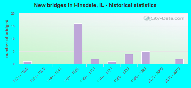
- New bridges - historical statistics
- 11920-1929
- 161950-1959
- 21960-1969
- 11970-1979
- 41980-1989
- 51990-1999
- 22010-2019

- Reconstructed bridges - Historical Statistics
- 21960-1969
- 01970-1979
- 21980-1989
- 11990-1999


- Bridge Condition - Deck
- 6.3%Very good
- 50.0%Good
- 37.5%Satisfactory
- 6.3%Poor

- Bridge Condition - Superstructure
- 6.3%Very good
- 31.3%Good
- 43.8%Satisfactory
- 12.5%Fair
- 6.3%Poor

- Bridge Condition - Substructure
- 12.5%Very good
- 43.8%Good
- 31.3%Satisfactory
- 6.3%Fair
- 6.3%Poor

- Bridge Condition - Channel
- 44.4%Good
- 33.3%Satisfactory
- 22.2%Fair
Find on map >> Show street view
Structure Number: 160223, Location: AT DU PAGE CO (Lat: 41.818419, Lng: -87.914900), Route carried "on" structure: US 34, Year Built: 1958, Year Reconstructed: 1992, Status: Open, Structure Length: 9.08m (29.79ft), Average Daily Traffic: 31,600 (year 2021), Truck Traffic: 6%, Average Future Daily Traffic: 31,621 (year 2032), Design Load: HS 20, Features Intersected: I-294 TRI STATE TOLL
Minimum Vertical Clearance: 30+ m (98+ ft), Kilometerpoint: 330.824, Lanes on structure: 4, Lanes under structure: 6, Base Highway Network: Yes, Owner: State Highway Agency, Approaching Roadway Width: 23.8m (78.1ft), Skew: 30 degrees, Material/Design: Prestressed concrete continuous, Design/Construction: Stringer/Multi-beam, Number Of Spans In Main Unit: 2, Number Of Approach Spans: 2, Length of Maximum Span: 21.9m (71.9ft), Curb or Sidewalk Widths: Left: 1.5m (4.9ft), Right: 1.5m (4.9ft), Curb-To-Curb Width: 23.8m (78.1ft), Out-to-Out Width: 28.7m (94.2ft)
Condition: Deck: Satisfactory, Superstructure: Satisfactory, Substructure: Good, Operating Rating: 64.8 metric tons, Method Used To Determine Operating Rating: Load Factor (LF) rating reported by rating factor (RF) method using MS18 loading, Inventory Rating: 38.9 metric tons, Method Used To Determine Inventory Rating: Load Factor (LF) rating reported by rating factor (RF) method using MS18 loading, Structural Evaluation: Equal to present minimum criteria, Deck Geometry: Superior to present desirable criteria, Underclear: High priority of corrective action, Approach Roadway Alignment: Equal to present desirable criteria, Designated Inspection Frequency: Every 24 months, Inspection Date: April 2021, Deck Structure Type: Concrete Cast-file-Place, Wearing Surface/Protective System: Deck Protection: Epoxy Coated Reinforcing
Find on map >> Show street view
Structure Number: 16261, Location: 2.1 M W OF US 45 (Lat: 41.789606, Lng: -87.908217), Route carried "on" structure: Other road , Year Built: 1992, Status: Open, Structure Length: 8.05m (26.41ft), Average Daily Traffic: 19,500 (year 2018), Truck Traffic: 7%, Average Future Daily Traffic: 20,806 (year 2032), Design Load: HS 20, Features Intersected: I-294 TRI STATE TOLL, Facility Carried by Structure: 55TH ST
Minimum Vertical Clearance: 30+ m (98+ ft), Kilometerpoint: 0.708, Lanes on structure: 4, Lanes under structure: 8, Base Highway Network: Yes, Owner: State Highway Agency, Approaching Roadway Width: 17.4m (57.1ft), Skew: 30 degrees, Material/Design: Prestressed concrete continuous, Design/Construction: Stringer/Multi-beam, Number Of Spans In Main Unit: 2, Number Of Approach Spans: 2, Length of Maximum Span: 33.2m (108.9ft), Curb or Sidewalk Widths: Left: 1.5m (4.9ft), Right: 1.5m (4.9ft), Curb-To-Curb Width: 17.4m (57.1ft), Out-to-Out Width: 20.4m (66.9ft)
Condition: Deck: Good, Superstructure: Satisfactory, Substructure: Satisfactory, Operating Rating: 71.3 metric tons, Method Used To Determine Operating Rating: Load Factor (LF) rating reported by rating factor (RF) method using MS18 loading, Inventory Rating: 42.8 metric tons, Method Used To Determine Inventory Rating: Load Factor (LF) rating reported by rating factor (RF) method using MS18 loading, Structural Evaluation: Equal to present minimum criteria, Deck Geometry: Somewhat better than minimum adequacy, Underclear: Meets minimum limits, Approach Roadway Alignment: Equal to present desirable criteria, Designated Inspection Frequency: Every 24 months, Inspection Date: March 2021, Deck Structure Type: Concrete Cast-file-Place, Wearing Surface/Protective System: Wearing Surface: Epoxy Overlay, Deck Protection: Epoxy Coated Reinforcing
Find on map >> Show street view
Structure Number: 162748, Location: 1.6 M N I-55 (Lat: 41.813708, Lng: -87.914067), Route carried "on" structure: Interstate 294, Year Built: 1958, Year Reconstructed: 1992, Status: Open, Structure Length: 1.49m (4.89ft), Average Daily Traffic: 154,800 (year 2020), Truck Traffic: 15%, Average Future Daily Traffic: 153,985 (year 2032), Design Load: HS 20, Features Intersected: STREAM
Minimum Vertical Clearance: 30+ m (98+ ft), Kilometerpoint: 41.568, Lanes on structure: 8, Base Highway Network: Yes, Toll: On toll road, Owner: State Toll Authority, Approaching Roadway Width: 44.5m (146.0ft), Material/Design: Concrete continuous, Design/Construction: Culvert, Number Of Spans In Main Unit: 3, Length of Maximum Span: 4.6m (15.1ft)
Condition: Channel: Satisfactory, Culverts: Satisfactory, Operating Rating: 97.2 metric tons, Method Used To Determine Operating Rating: Load Factor (LF) rating reported by rating factor (RF) method using MS18 loading, Inventory Rating: 68.0 metric tons, Method Used To Determine Inventory Rating: Load Factor (LF) rating reported by rating factor (RF) method using MS18 loading, Structural Evaluation: Equal to present minimum criteria, Waterway Adequacy: Equal to present desirable criteria, Approach Roadway Alignment: Equal to present desirable criteria, Designated Inspection Frequency: Every 24 months, Inspection Date: April 2021
Find on map >> Show street view
Structure Number: 162749, Location: 1.3 M N I-55 (Lat: 41.773806, Lng: -87.907664), Route carried "on" structure: Interstate 294, Year Built: 1958, Status: Open, Structure Length: 0.70m (2.30ft), Average Daily Traffic: 152,100 (year 2020), Truck Traffic: 19%, Average Future Daily Traffic: 150,277 (year 2032), Design Load: HS 20, Features Intersected: STREAM
Minimum Vertical Clearance: 30+ m (98+ ft), Kilometerpoint: 46.074, Lanes on structure: 8, Base Highway Network: Yes, Toll: On toll road, Owner: State Toll Authority, Approaching Roadway Width: 44.5m (146.0ft), Material/Design: Concrete continuous, Design/Construction: Culvert, Number Of Spans In Main Unit: 2, Length of Maximum Span: 3.0m (9.8ft)
Condition: Channel: Satisfactory, Culverts: Satisfactory, Inventory Rating: 97.2 metric tons, Method Used To Determine Inventory Rating: Load Factor (LF) rating reported by rating factor (RF) method using MS18 loading, Structural Evaluation: Equal to present minimum criteria, Waterway Adequacy: Superior to present desirable criteria, Approach Roadway Alignment: Equal to present desirable criteria, Designated Inspection Frequency: Every 24 months, Inspection Date: April 2021
Find on map >> Show street view
Structure Number: 169812, Location: 0.9 M S US 34 P10 (Lat: 41.805511, Lng: -87.911611), Route carried "on" structure: Interstate 294, Year Built: 1958, Status: Open, Structure Length: 4.08m (13.39ft), Average Daily Traffic: 77,400 (year 2020), Truck Traffic: 15%, Average Future Daily Traffic: 76,993 (year 2032), Features Intersected: FLAG CR NORTH
Minimum Vertical Clearance: 30+ m (98+ ft), Kilometerpoint: 42.502, Lanes on structure: 3, Base Highway Network: Yes, Toll: On toll road, Owner: State Toll Authority, Approaching Roadway Width: 15.8m (51.8ft), Skew: 4 degrees, Material/Design: Prestressed concrete, Design/Construction: Stringer/Multi-beam, Number Of Spans In Main Unit: 3, Length of Maximum Span: 13.1m (43.0ft), Curb-To-Curb Width: 14.2m (46.6ft), Out-to-Out Width: 18.6m (61.0ft)
Condition: Deck: Good, Superstructure: Good, Substructure: Good, Channel: Good, Operating Rating: 84.6 metric tons, Method Used To Determine Operating Rating: Load Factor (LF) rating reported by rating factor (RF) method using MS18 loading, Inventory Rating: 50.5 metric tons, Method Used To Determine Inventory Rating: Load Factor (LF) rating reported by rating factor (RF) method using MS18 loading, Structural Evaluation: Better than present minimum criteria, Deck Geometry: Meets minimum limits, Waterway Adequacy: Superior to present desirable criteria, Approach Roadway Alignment: Equal to present desirable criteria, Designated Inspection Frequency: Every 24 months, Underwater Inspection Frequency: Every 60 months, Inspection Date: April 2021, Underwater Inspection Date: April 2018, Deck Structure Type: Concrete Cast-file-Place, Wearing Surface/Protective System: Wearing Surface: Bituminous
Find on map >> Show street view
Structure Number: 169813, Location: 0.9 M S US 34 P10 (Lat: 41.805372, Lng: -87.911561), Route carried "on" structure: Interstate 294, Year Built: 1958, Status: Open, Structure Length: 4.08m (13.39ft), Average Daily Traffic: 77,400 (year 2020), Truck Traffic: 15%, Average Future Daily Traffic: 76,993 (year 2032), Features Intersected: FLAG CR NORTH
Minimum Vertical Clearance: 30+ m (98+ ft), Kilometerpoint: 42.518, Lanes on structure: 3, Base Highway Network: Yes, Toll: On toll road, Owner: State Toll Authority, Approaching Roadway Width: 15.8m (51.8ft), Skew: 4 degrees, Material/Design: Prestressed concrete, Design/Construction: Stringer/Multi-beam, Number Of Spans In Main Unit: 3, Length of Maximum Span: 13.1m (43.0ft), Curb-To-Curb Width: 14.2m (46.6ft), Out-to-Out Width: 18.6m (61.0ft)
Condition: Deck: Satisfactory, Superstructure: Good, Substructure: Good, Channel: Good, Operating Rating: 84.6 metric tons, Method Used To Determine Operating Rating: Load Factor (LF) rating reported by rating factor (RF) method using MS18 loading, Inventory Rating: 50.5 metric tons, Method Used To Determine Inventory Rating: Load Factor (LF) rating reported by rating factor (RF) method using MS18 loading, Structural Evaluation: Better than present minimum criteria, Deck Geometry: Meets minimum limits, Waterway Adequacy: Superior to present desirable criteria, Approach Roadway Alignment: Equal to present desirable criteria, Designated Inspection Frequency: Every 24 months, Underwater Inspection Frequency: Every 60 months, Inspection Date: April 2021, Underwater Inspection Date: April 2018, Deck Structure Type: Concrete Cast-file-Place, Wearing Surface/Protective System: Wearing Surface: Bituminous
Find on map >> Show street view
Structure Number: 169814, Location: 0.2 M N US 66 P10 (Lat: 41.765756, Lng: -87.902831), Route carried "on" structure: Interstate 294, Year Built: 1958, Year Reconstructed: 1973, Status: Open, Structure Length: 5.00m (16.40ft), Average Daily Traffic: 52,100 (year 2021), Truck Traffic: 26%, Average Future Daily Traffic: 59,586 (year 2032), Features Intersected: FLAG CR SOUTH
Minimum Vertical Clearance: 30+ m (98+ ft), Kilometerpoint: 47.088, Lanes on structure: 3, Base Highway Network: Yes, Toll: On toll road, Owner: State Toll Authority, Approaching Roadway Width: 15.8m (51.8ft), Skew: 3 degrees, Material/Design: Prestressed concrete, Design/Construction: Stringer/Multi-beam, Number Of Spans In Main Unit: 2, Length of Maximum Span: 24.1m (79.1ft), Curb-To-Curb Width: 14.3m (46.9ft), Out-to-Out Width: 18.6m (61.0ft)
Condition: Deck: Satisfactory, Superstructure: Satisfactory, Substructure: Satisfactory, Channel: Fair, Operating Rating: 74.8 metric tons, Method Used To Determine Operating Rating: Load Factor (LF) rating reported by rating factor (RF) method using MS18 loading, Inventory Rating: 44.7 metric tons, Method Used To Determine Inventory Rating: Load Factor (LF) rating reported by rating factor (RF) method using MS18 loading, Structural Evaluation: Equal to present minimum criteria, Deck Geometry: Meets minimum limits, Waterway Adequacy: Superior to present desirable criteria, Approach Roadway Alignment: Equal to present desirable criteria, Designated Inspection Frequency: Every 24 months, Underwater Inspection Frequency: Every 60 months, Inspection Date: April 2021, Underwater Inspection Date: April 2018, Deck Structure Type: Concrete Cast-file-Place, Wearing Surface/Protective System: Wearing Surface: Bituminous, Membrane: Built-up
Find on map >> Show street view
Structure Number: 169815, Location: 0.2 M N US 66 P10 (Lat: 41.765636, Lng: -87.902692), Route carried "on" structure: Interstate 294, Year Built: 1958, Year Reconstructed: 1973, Status: Open, Structure Length: 5.00m (16.40ft), Average Daily Traffic: 52,100 (year 2021), Truck Traffic: 26%, Average Future Daily Traffic: 59,586 (year 2032), Features Intersected: FLAG CR SOUTH
Minimum Vertical Clearance: 30+ m (98+ ft), Kilometerpoint: 47.104, Lanes on structure: 3, Base Highway Network: Yes, Toll: On toll road, Owner: State Toll Authority, Approaching Roadway Width: 15.8m (51.8ft), Skew: 3 degrees, Material/Design: Prestressed concrete, Design/Construction: Stringer/Multi-beam, Number Of Spans In Main Unit: 2, Length of Maximum Span: 24.1m (79.1ft), Curb-To-Curb Width: 14.3m (46.9ft), Out-to-Out Width: 18.6m (61.0ft)
Condition: Deck: Satisfactory, Superstructure: Satisfactory, Substructure: Satisfactory, Channel: Satisfactory, Operating Rating: 74.8 metric tons, Method Used To Determine Operating Rating: Load Factor (LF) rating reported by rating factor (RF) method using MS18 loading, Inventory Rating: 44.7 metric tons, Method Used To Determine Inventory Rating: Load Factor (LF) rating reported by rating factor (RF) method using MS18 loading, Structural Evaluation: Equal to present minimum criteria, Deck Geometry: Meets minimum limits, Waterway Adequacy: Superior to present desirable criteria, Approach Roadway Alignment: Equal to present desirable criteria, Designated Inspection Frequency: Every 24 months, Underwater Inspection Frequency: Every 60 months, Inspection Date: April 2021, Underwater Inspection Date: April 2018, Deck Structure Type: Concrete Cast-file-Place, Wearing Surface/Protective System: Wearing Surface: Bituminous
Find on map >> Show street view
Structure Number: 169816, Location: 0.4 M NW I55 P10 (Lat: 41.763989, Lng: -87.900478), Route carried "on" structure: Interstate 294, Year Built: 1958, Status: Open, Structure Length: 2.19m (7.19ft), Average Daily Traffic: 52,100 (year 2021), Truck Traffic: 26%, Average Future Daily Traffic: 59,586 (year 2032), Features Intersected: JOLIET RD
Minimum Vertical Clearance: 30+ m (98+ ft), Kilometerpoint: 47.346, Lanes on structure: 3, Lanes under structure: 4, Base Highway Network: Yes, Toll: On toll road, Owner: State Toll Authority, Approaching Roadway Width: 15.8m (51.8ft), Skew: 1 degrees, Material/Design: Prestressed concrete, Design/Construction: Stringer/Multi-beam, Number Of Spans In Main Unit: 1, Length of Maximum Span: 21.0m (68.9ft), Curb-To-Curb Width: 14.3m (46.9ft), Out-to-Out Width: 18.6m (61.0ft)
Condition: Deck: Good, Superstructure: Satisfactory, Substructure: Good, Operating Rating: 77.8 metric tons, Method Used To Determine Operating Rating: Load Factor (LF) rating reported by rating factor (RF) method using MS18 loading, Inventory Rating: 46.7 metric tons, Method Used To Determine Inventory Rating: Load Factor (LF) rating reported by rating factor (RF) method using MS18 loading, Structural Evaluation: Equal to present minimum criteria, Deck Geometry: Meets minimum limits, Underclear: Meets minimum limits, Approach Roadway Alignment: Equal to present desirable criteria, Length Of Structure Improvement: 2.19m (7.19ft), Designated Inspection Frequency: Every 24 months, Inspection Date: June 2019, Bridge Improvement Cost: $277,000, Roadway Improvement Cost: $28,000, Total Project Cost: $416,000, Deck Structure Type: Concrete Cast-file-Place, Wearing Surface/Protective System: Wearing Surface: Bituminous, Membrane: Built-up
Find on map >> Show street view
Structure Number: 169817, Location: 0.4 M NW I55 P10 (Lat: 41.763928, Lng: -87.900383), Route carried "on" structure: Interstate 294, Year Built: 1958, Status: Open, Structure Length: 2.19m (7.19ft), Average Daily Traffic: 52,100 (year 2021), Truck Traffic: 26%, Average Future Daily Traffic: 59,586 (year 2032), Features Intersected: JOLIET RD
Minimum Vertical Clearance: 30+ m (98+ ft), Kilometerpoint: 47.362, Lanes on structure: 3, Lanes under structure: 4, Base Highway Network: Yes, Toll: On toll road, Owner: State Toll Authority, Approaching Roadway Width: 15.8m (51.8ft), Skew: 1 degrees, Material/Design: Prestressed concrete, Design/Construction: Stringer/Multi-beam, Number Of Spans In Main Unit: 1, Length of Maximum Span: 21.0m (68.9ft), Curb-To-Curb Width: 14.3m (46.9ft), Out-to-Out Width: 18.6m (61.0ft)
Condition: Deck: Good, Superstructure: Satisfactory, Substructure: Satisfactory, Operating Rating: 77.8 metric tons, Method Used To Determine Operating Rating: Load Factor (LF) rating reported by rating factor (RF) method using MS18 loading, Inventory Rating: 46.7 metric tons, Method Used To Determine Inventory Rating: Load Factor (LF) rating reported by rating factor (RF) method using MS18 loading, Structural Evaluation: Equal to present minimum criteria, Deck Geometry: Meets minimum limits, Underclear: Meets minimum limits, Approach Roadway Alignment: Equal to present desirable criteria, Designated Inspection Frequency: Every 24 months, Inspection Date: June 2019, Deck Structure Type: Concrete Cast-file-Place, Wearing Surface/Protective System: Wearing Surface: Bituminous, Membrane: Built-up
Find on map >> Show street view
Structure Number: 169995, Location: 1 M N US 66 P10 (Lat: 41.774614, Lng: -87.907967), Route carried "on" structure: Other road , Year Built: 1958, Status: Open, Structure Length: 11.80m (38.71ft), Average Daily Traffic: 14,200 (year 2018), Truck Traffic: 5%, Average Future Daily Traffic: 14,317 (year 2032), Design Load: HS 20, Features Intersected: I 294, Facility Carried by Structure: PLAINFIELD RD
Minimum Vertical Clearance: 30+ m (98+ ft), Kilometerpoint: 0.772, Lanes on structure: 2, Lanes under structure: 7, Owner: County Highway Agency, Approaching Roadway Width: 12.2m (40.0ft), Skew: 2 degrees, Material/Design: Prestressed concrete, Design/Construction: Stringer/Multi-beam, Number Of Spans In Main Unit: 6, Length of Maximum Span: 25.9m (85.0ft), Curb or Sidewalk Widths: Left: 1.5m (4.9ft), Right: 1.5m (4.9ft), Curb-To-Curb Width: 9.1m (29.9ft), Out-to-Out Width: 12.8m (42.0ft)
Condition: Deck: Good, Superstructure: Good, Substructure: Fair, Channel: Good, Operating Rating: 88.5 metric tons, Method Used To Determine Operating Rating: Load Factor (LF) rating reported by rating factor (RF) method using MS18 loading, Inventory Rating: 53.1 metric tons, Method Used To Determine Inventory Rating: Load Factor (LF) rating reported by rating factor (RF) method using MS18 loading, Structural Evaluation: Somewhat better than minimum adequacy, Deck Geometry: Meets minimum limits, Underclear: Meets minimum limits, Waterway Adequacy: Equal to present desirable criteria, Approach Roadway Alignment: Equal to present desirable criteria, Designated Inspection Frequency: Every 24 months, Inspection Date: March 2021, Deck Structure Type: Concrete Cast-file-Place
Find on map >> Show street view
Structure Number: 220126, Location: 1.5 M S US 34 (Lat: 41.788619, Lng: -87.947056), Route carried "on" structure: Other road , Year Built: 1967, Year Reconstructed: 2004, Status: Open, Structure Length: 6.59m (21.62ft), Average Daily Traffic: 21,000 (year 2020), Truck Traffic: 5%, Average Future Daily Traffic: 61,270 (year 2032), Design Load: HS 20, Features Intersected: IL 83, Facility Carried by Structure: 55TH ST
Minimum Vertical Clearance: 30+ m (98+ ft), Kilometerpoint: 5.987, Lanes on structure: 6, Lanes under structure: 6, Base Highway Network: Yes, Owner: State Highway Agency, Approaching Roadway Width: 21.2m (69.6ft), Skew: 30 degrees, Material/Design: Steel continuous, Design/Construction: Stringer/Multi-beam, Number Of Spans In Main Unit: 4, Length of Maximum Span: 19.4m (63.6ft), Curb or Sidewalk Widths: Left: 1.8m (5.9ft), Right: 0.0m, Curb-To-Curb Width: 21.2m (69.6ft), Out-to-Out Width: 29.0m (95.1ft)
Condition: Deck: Good, Superstructure: Good, Substructure: Good, Operating Rating: 72.3 metric tons, Method Used To Determine Operating Rating: Load Factor (LF) rating reported by rating factor (RF) method using MS18 loading, Inventory Rating: 43.1 metric tons, Method Used To Determine Inventory Rating: Load Factor (LF) rating reported by rating factor (RF) method using MS18 loading, Structural Evaluation: Better than present minimum criteria, Deck Geometry: High priority of replacement, Underclear: Somewhat better than minimum adequacy, Approach Roadway Alignment: Equal to present desirable criteria, Designated Inspection Frequency: Every 48 months, Inspection Date: June 2020, Deck Structure Type: Concrete Cast-file-Place, Wearing Surface/Protective System: Deck Protection: Epoxy Coated Reinforcing
Find on map >> Show street view
Structure Number: 220155, Location: 0.7 M S OF US 34 (Lat: 41.799014, Lng: -87.946697), Route carried "on" structure: State highway 83, Year Built: 1986, Status: Open, Structure Length: 8.69m (28.51ft), Average Daily Traffic: 62,100 (year 2021), Truck Traffic: 11%, Average Future Daily Traffic: 73,970 (year 2032), Design Load: HS 20, Features Intersected: RR - BNSF, BRLGTN RD
Minimum Vertical Clearance: 30+ m (98+ ft), Kilometerpoint: 62.634, Lanes on structure: 4, Lanes under structure: 2, Base Highway Network: Yes, Owner: State Highway Agency, Approaching Roadway Width: 16.8m (55.1ft), Skew: 31 degrees, Material/Design: Prestressed concrete continuous, Design/Construction: Stringer/Multi-beam, Number Of Spans In Main Unit: 5, Length of Maximum Span: 22.9m (75.1ft), Curb-To-Curb Width: 16.9m (55.4ft), Out-to-Out Width: 17.9m (58.7ft)
Condition: Deck: Satisfactory, Superstructure: Fair, Substructure: Good, Operating Rating: 73.5 metric tons, Method Used To Determine Operating Rating: Load Factor (LF) rating reported by rating factor (RF) method using MS18 loading, Inventory Rating: 42.4 metric tons, Method Used To Determine Inventory Rating: Load Factor (LF) rating reported by rating factor (RF) method using MS18 loading, Structural Evaluation: Somewhat better than minimum adequacy, Deck Geometry: Somewhat better than minimum adequacy, Underclear: High priority of corrective action, Approach Roadway Alignment: Equal to present minimum criteria, Length Of Structure Improvement: 8.69m (28.51ft), Designated Inspection Frequency: Every 24 months, Inspection Date: Febuary 2021, Bridge Improvement Cost: $335,000, Roadway Improvement Cost: $17,000, Total Project Cost: $402,000, Deck Structure Type: Concrete Cast-file-Place, Wearing Surface/Protective System: Wearing Surface: Latex Concrete, Deck Protection: Epoxy Coated Reinforcing
Find on map >> Show street view
Structure Number: 220157, Location: 1.5 M W OF I-294 (Lat: 41.811750, Lng: -87.947333), Route carried "on" structure: State highway 83, Year Built: 1986, Status: Open, Structure Length: 4.85m (15.91ft), Average Daily Traffic: 62,100 (year 2021), Truck Traffic: 11%, Average Future Daily Traffic: 67,843 (year 2032), Design Load: HS 20, Features Intersected: US 34
Minimum Vertical Clearance: 30+ m (98+ ft), Kilometerpoint: 63.954, Lanes on structure: 5, Lanes under structure: 5, Base Highway Network: Yes, Owner: State Highway Agency, Approaching Roadway Width: 24.1m (79.1ft), Skew: 30 degrees, Material/Design: Prestressed concrete continuous, Design/Construction: Stringer/Multi-beam, Number Of Spans In Main Unit: 3, Length of Maximum Span: 24.4m (80.1ft), Curb-To-Curb Width: 27.1m (88.9ft), Out-to-Out Width: 28.1m (92.2ft)
Condition: Deck: Good, Superstructure: Fair, Substructure: Good, Operating Rating: 79.7 metric tons, Method Used To Determine Operating Rating: Load Factor (LF) rating reported by rating factor (RF) method using MS18 loading, Inventory Rating: 45.4 metric tons, Method Used To Determine Inventory Rating: Load Factor (LF) rating reported by rating factor (RF) method using MS18 loading, Structural Evaluation: Somewhat better than minimum adequacy, Deck Geometry: Superior to present desirable criteria, Underclear: Meets minimum limits, Approach Roadway Alignment: Equal to present minimum criteria, Designated Inspection Frequency: Every 24 months, Inspection Date: Febuary 2021, Deck Structure Type: Concrete Cast-file-Place, Wearing Surface/Protective System: Wearing Surface: Latex Concrete, Deck Protection: Epoxy Coated Reinforcing
Find on map >> Show street view
Structure Number: 220211, Location: 0.5 M S OF US 34 (Lat: 41.803328, Lng: -87.946639), Route carried "on" structure: Other road , Year Built: 1991, Status: Open, Structure Length: 3.11m (10.20ft), Average Daily Traffic: 4,100 (year 2020), Truck Traffic: 4%, Average Future Daily Traffic: 7,909 (year 2032), Design Load: HS 20+Mod, Features Intersected: IL 83, Facility Carried by Structure: CHICAGO AVE
Minimum Vertical Clearance: 30+ m (98+ ft), Kilometerpoint: 17.557, Lanes on structure: 2, Lanes under structure: 4, Owner: State Highway Agency, Approaching Roadway Width: 9.1m (29.9ft), Material/Design: Prestressed concrete continuous, Design/Construction: Stringer/Multi-beam, Number Of Spans In Main Unit: 2, Length of Maximum Span: 15.5m (50.9ft), Curb or Sidewalk Widths: Left: 0.0m, Right: 3.0m (9.8ft), Curb-To-Curb Width: 9.1m (29.9ft), Out-to-Out Width: 13.4m (44.0ft)
Condition: Deck: Good, Superstructure: Satisfactory, Substructure: Satisfactory, Operating Rating: 79.4 metric tons, Method Used To Determine Operating Rating: Load Factor (LF) rating reported by rating factor (RF) method using MS18 loading, Inventory Rating: 45.0 metric tons, Method Used To Determine Inventory Rating: Load Factor (LF) rating reported by rating factor (RF) method using MS18 loading, Structural Evaluation: Equal to present minimum criteria, Deck Geometry: Meets minimum limits, Underclear: High priority of replacement, Approach Roadway Alignment: Better than present minimum criteria, Length Of Structure Improvement: 4.05m (13.29ft), Designated Inspection Frequency: Every 24 months, Inspection Date: May 2021, Bridge Improvement Cost: $690,000, Roadway Improvement Cost: $69,000, Total Project Cost: $1,035,000, Deck Structure Type: Concrete Cast-file-Place, Wearing Surface/Protective System: Deck Protection: Epoxy Coated Reinforcing
Find on map >> Show street view
Structure Number: 223049, Location: 1M S. 31ST ST (Lat: 41.821647, Lng: -87.926722), Route carried "on" structure: Other road , Year Built: 1996, Status: Open, Structure Length: 5.57m (18.27ft), Average Daily Traffic: 8,650 (year 2020), Truck Traffic: 3%, Average Future Daily Traffic: 14,705 (year 2032), Design Load: HS 20, Features Intersected: SALT CREEK, Facility Carried by Structure: YORK RD
Minimum Vertical Clearance: 30+ m (98+ ft), Kilometerpoint: 15.900, Lanes on structure: 2, Base Highway Network: Yes, Owner: County Highway Agency, Approaching Roadway Width: 12.2m (40.0ft), Skew: 21 degrees, Material/Design: Prestressed concrete, Design/Construction: Box Beam or Girders - Multiple, Number Of Spans In Main Unit: 3, Length of Maximum Span: 20.8m (68.2ft), Curb or Sidewalk Widths: Left: 2.8m (9.2ft), Right: 2.8m (9.2ft), Curb-To-Curb Width: 12.2m (40.0ft), Out-to-Out Width: 19.3m (63.3ft)
Condition: Deck: Satisfactory, Superstructure: Good, Substructure: Very good, Channel: Good, Operating Rating: 44.1 metric tons, Method Used To Determine Operating Rating: Assigned rating based on Load Factor Design (LFD) reported by rating factor (RF) using MS18 loading, Inventory Rating: 32.4 metric tons, Method Used To Determine Inventory Rating: Assigned rating based on Load Factor Design (LFD) reported by rating factor (RF) using MS18 loading, Structural Evaluation: Better than present minimum criteria, Deck Geometry: Somewhat better than minimum adequacy, Waterway Adequacy: Better than present minimum criteria, Approach Roadway Alignment: Equal to present desirable criteria, Designated Inspection Frequency: Every 24 months, Inspection Date: September 2020, Deck Structure Type: Concrete Precast Panels, Wearing Surface/Protective System: Wearing Surface: Integral Concrete, Deck Protection: Epoxy Coated Reinforcing
Find on map >> Show street view
Structure Number: 226011, Location: .01 M W Salt Crk. Ln (Lat: 41.820678, Lng: -87.922033), Route carried "on" structure: City street , Year Built: 1976, Status: Open, Structure Length: 2.22m (7.28ft), Average Daily Traffic: 650 (year 2020), Truck Traffic: 9%, Average Future Daily Traffic: 750 (year 2032), Features Intersected: Salt Creek, Facility Carried by Structure: Fox Lane
Minimum Vertical Clearance: 30+ m (98+ ft), Kilometerpoint: 0.402, Lanes on structure: 2, Owner: City or Municipal Highway Agency, Approaching Roadway Width: 8.5m (27.9ft), Skew: 2 degrees, Material/Design: Prestressed concrete, Design/Construction: Box Beam or Girders - Multiple, Number Of Spans In Main Unit: 1, Length of Maximum Span: 22.0m (72.2ft), Curb or Sidewalk Widths: Left: 1.0m (3.3ft), Right: 1.0m (3.3ft), Curb-To-Curb Width: 8.3m (27.2ft), Out-to-Out Width: 11.0m (36.1ft)
Condition: Deck: Poor, Superstructure: Poor, Substructure: Poor, Channel: Fair, Operating Rating: 40.5 metric tons, Method Used To Determine Operating Rating: Field evaluation and documented engineering judgment, Inventory Rating: 24.3 metric tons, Method Used To Determine Inventory Rating: Field evaluation and documented engineering judgment, Structural Evaluation: Meets minimum limits, Deck Geometry: Somewhat better than minimum adequacy, Waterway Adequacy: Equal to present desirable criteria, Approach Roadway Alignment: Equal to present desirable criteria, Designated Inspection Frequency: Every 24 months, Inspection Date: April 2021, Deck Structure Type: Concrete Precast Panels, Wearing Surface/Protective System: Wearing Surface: Bituminous, Membrane: Other
Find on map >> Show street view
Structure Number: 226404, Location: 0.7MI.N.ofChicagoAve (Lat: 41.804892, Lng: -87.920081), Route carried "on" structure: City street , Year Built: 2015, Status: Open, Structure Length: 5.29m (17.36ft), Average Daily Traffic: 3,100 (year 2020), Truck Traffic: 6%, Average Future Daily Traffic: 344 (year 2032), Design Load: HS 25 or greater, Features Intersected: BNSF RR, Facility Carried by Structure: Oak Street
Minimum Vertical Clearance: 30+ m (98+ ft), Kilometerpoint: 0.338, Lanes on structure: 2, Owner: City or Municipal Highway Agency, Approaching Roadway Width: 9.1m (29.9ft), Skew: 1 degrees, Material/Design: Steel, Design/Construction: Stringer/Multi-beam, Number Of Spans In Main Unit: 3, Length of Maximum Span: 21.3m (69.9ft), Curb or Sidewalk Widths: Left: 1.7m (5.6ft), Right: 1.7m (5.6ft), Curb-To-Curb Width: 9.1m (29.9ft), Out-to-Out Width: 13.2m (43.3ft)
Condition: Deck: Very good, Superstructure: Very good, Substructure: Very good, Operating Rating: 42.1 metric tons, Method Used To Determine Operating Rating: Assigned ratings based on Load and Resistance Factor Design (LRFD) reported by rating factor (RF) using HL93 loadings, Inventory Rating: 32.4 metric tons, Method Used To Determine Inventory Rating: Assigned ratings based on Load and Resistance Factor Design (LRFD) reported by rating factor (RF) using HL93 loadings, Structural Evaluation: Equal to present desirable criteria, Deck Geometry: Meets minimum limits, Underclear: Superior to present desirable criteria, Approach Roadway Alignment: Equal to present desirable criteria, Designated Inspection Frequency: Every 48 months, Inspection Date: April 2021, Deck Structure Type: Concrete Cast-file-Place, Wearing Surface/Protective System: Deck Protection: Epoxy Coated Reinforcing
Find on map >> Show street view
Structure Number: 160223, Location: AT DU PAGE CO (Lat: 41.818497, Lng: -87.914403), Route carried "under" structure: Interstate 294, Year Built: 1958, Structure Length: 0. m, Average Daily Traffic: 154,800 (year 2020), Truck Traffic: 15%, Features Intersected: I-294 TRI STATE TOLL, Facility Carried by Structure: US 34 (OGDEN AVE)
Minimum Vertical Clearance: 4.65m (15.26ft), Kilometerpoint: 41.037, Lanes on structure: 4, Lanes under structure: 6, Material/Design: Prestressed concrete continuous, Design/Construction: Stringer/Multi-beam, Length of Maximum Span: 21.9m (71.9ft)
Find on map >> Show street view
Structure Number: 16261, Location: 2.1 M W OF US 45 (Lat: 41.789606, Lng: -87.908217), Route carried "under" structure: Interstate 294, Year Built: 1992, Structure Length: 0. m, Average Daily Traffic: 154,800 (year 2020), Truck Traffic: 15%, Features Intersected: I-294 TRI STATE TOLL, Facility Carried by Structure: 55TH ST
Minimum Vertical Clearance: 4.65m (15.26ft), Kilometerpoint: 44.320, Lanes on structure: 4, Lanes under structure: 8, Material/Design: Prestressed concrete continuous, Design/Construction: Stringer/Multi-beam, Length of Maximum Span: 33.2m (108.9ft)
Find on map >> Show street view
Structure Number: 169694, Location: .4M S of 55th St (Lat: 41.783542, Lng: -87.908047), Route carried "under" structure: Interstate 294, Year Built: 2015, Structure Length: 0. m, Average Daily Traffic: 152,100 (year 2020), Truck Traffic: 19%, Features Intersected: I294, Facility Carried by Structure: Hinsdale Oasis
Minimum Vertical Clearance: 4.57m (14.99ft), Kilometerpoint: 44.980, Lanes under structure: 8, Material/Design: Prestressed concrete, Length of Maximum Span: 0.0m
Find on map >> Show street view
Structure Number: 169811, Location: 0.8 M S US 34 P10 (Lat: 41.806492, Lng: -87.911981), Route carried "under" structure: Interstate 294, Year Built: 1958, Structure Length: 0. m, Average Daily Traffic: 154,800 (year 2020), Truck Traffic: 15%, Features Intersected: I-294 (TRI-ST TOLL), Facility Carried by Structure: CB&Q RR
Minimum Vertical Clearance: 4.65m (15.26ft), Kilometerpoint: 42.389, Lanes under structure: 6, Material/Design: Steel, Design/Construction: Stringer/Multi-beam, Length of Maximum Span: 19.8m (65.0ft)
Find on map >> Show street view
Structure Number: 169816, Location: 0.4 M NW I55 P10 (Lat: 41.764036, Lng: -87.900064), Route carried "under" structure: Other road , Year Built: 1958, Structure Length: 0. m, Average Daily Traffic: 13,200 (year 2021), Truck Traffic: 5%, Features Intersected: JOLIET RD, Facility Carried by Structure: I-294 NB
Minimum Vertical Clearance: 4.34m (14.24ft), Kilometerpoint: 0.949, Lanes on structure: 3, Lanes under structure: 4, Toll: On toll road, Material/Design: Prestressed concrete, Design/Construction: Stringer/Multi-beam, Length of Maximum Span: 21.0m (68.9ft)
Find on map >> Show street view
Structure Number: 169817, Location: 0.4 M NW I55 P10 (Lat: 41.763894, Lng: -87.900331), Route carried "under" structure: Other road , Year Built: 1958, Structure Length: 0. m, Average Daily Traffic: 13,200 (year 2021), Truck Traffic: 5%, Features Intersected: JOLIET RD, Facility Carried by Structure: I-294 SB
Minimum Vertical Clearance: 4.34m (14.24ft), Kilometerpoint: 0.917, Lanes on structure: 3, Lanes under structure: 4, Toll: On toll road, Material/Design: Prestressed concrete, Design/Construction: Stringer/Multi-beam, Length of Maximum Span: 21.0m (68.9ft)
Find on map >> Show street view
Structure Number: 169863, Location: 0.5 M N US 66 P10 (Lat: 41.770544, Lng: -87.906533), Route carried "under" structure: Interstate 294, Year Built: 1928, Structure Length: 0. m, Average Daily Traffic: 104,200 (year 2021), Truck Traffic: 26%, Features Intersected: I 294
Minimum Vertical Clearance: 4.72m (15.49ft), Kilometerpoint: 46.525, Lanes on structure: 2, Lanes under structure: 6, Toll: On toll road, Material/Design: Prestressed concrete, Design/Construction: Stringer/Multi-beam, Length of Maximum Span: 50.3m (165.0ft)
Find on map >> Show street view
Structure Number: 169992, Location: 0.4 M S US 34 P10 (Lat: 41.813272, Lng: -87.914047), Route carried "under" structure: Interstate 294, Year Built: 1958, Structure Length: 0. m, Average Daily Traffic: 154,800 (year 2020), Truck Traffic: 15%, Features Intersected: I-294 (TRI-ST TOLL), Facility Carried by Structure: PED OVERPASS
Minimum Vertical Clearance: 4.65m (15.26ft), Kilometerpoint: 41.616, Lanes under structure: 6, Material/Design: Prestressed concrete, Length of Maximum Span: 20.1m (65.9ft)
Find on map >> Show street view
Structure Number: 169995, Location: 1 M N US 66 P10 (Lat: 41.774683, Lng: -87.907794), Route carried "under" structure: Interstate 294, Year Built: 1958, Structure Length: 0. m, Average Daily Traffic: 152,100 (year 2020), Truck Traffic: 19%, Features Intersected: I 294, Facility Carried by Structure: PLAINFIELD RD
Minimum Vertical Clearance: 4.95m (16.24ft), Kilometerpoint: 45.962, Lanes on structure: 2, Lanes under structure: 7, Material/Design: Prestressed concrete, Design/Construction: Stringer/Multi-beam, Length of Maximum Span: 25.9m (85.0ft)
Find on map >> Show street view
Structure Number: 220126, Location: 1.5 M S US 34 (Lat: 41.788619, Lng: -87.947056), Route carried "under" structure: State highway 83, Year Built: 1967, Structure Length: 0. m, Average Daily Traffic: 51,100 (year 2021), Truck Traffic: 7%, Features Intersected: IL 83, Facility Carried by Structure: 55TH ST
Minimum Vertical Clearance: 4.62m (15.16ft), Kilometerpoint: 61.491, Lanes on structure: 6, Lanes under structure: 6, Material/Design: Steel continuous, Design/Construction: Stringer/Multi-beam, Length of Maximum Span: 19.4m (63.6ft)
Find on map >> Show street view
Structure Number: 220155, Location: 0.7 M S OF US 34 (Lat: 41.799014, Lng: -87.946697), Route carried "under" structure: Other road , Year Built: 1986, Structure Length: 0. m, Average Daily Traffic: 850 (year 2020), Truck Traffic: 9%, Features Intersected: RR - BNSF, BRLGTN RD, Facility Carried by Structure: IL 83
Minimum Vertical Clearance: 7.01m (23.00ft), Kilometerpoint: 2.494, Lanes on structure: 4, Lanes under structure: 2, Material/Design: Prestressed concrete continuous, Design/Construction: Stringer/Multi-beam, Length of Maximum Span: 22.9m (75.1ft)
Find on map >> Show street view
Structure Number: 220157, Location: 1.5 M W OF I-294 (Lat: 41.810733, Lng: -87.946947), Route carried "under" structure: US 34, Year Built: 1986, Structure Length: 0. m, Average Daily Traffic: 26,900 (year 2021), Truck Traffic: 7%, Features Intersected: US 34, Facility Carried by Structure: IL 83
Minimum Vertical Clearance: 4.47m (14.67ft), Kilometerpoint: 328.056, Lanes on structure: 5, Lanes under structure: 5, Material/Design: Prestressed concrete continuous, Design/Construction: Stringer/Multi-beam, Length of Maximum Span: 24.4m (80.1ft)
Find on map >> Show street view
Structure Number: 220211, Location: 0.5 M S OF US 34 (Lat: 41.803328, Lng: -87.946639), Route carried "under" structure: State highway 83, Year Built: 1991, Structure Length: 0. m, Average Daily Traffic: 62,100 (year 2021), Truck Traffic: 11%, Features Intersected: IL 83, Facility Carried by Structure: CHICAGO AVE
Minimum Vertical Clearance: 4.60m (15.09ft), Kilometerpoint: 63.133, Lanes on structure: 2, Lanes under structure: 4, Material/Design: Prestressed concrete continuous, Design/Construction: Stringer/Multi-beam, Length of Maximum Span: 15.5m (50.9ft)