Bridge Statistics for Johnston City, Illinois (IL)
Condition, Traffic, Stress, Structural Evaluation, Project Costs
- National Bridge Inventory (NBI) Statistics
- 17Number of bridges
- 174ft / 52.8mTotal length
- $2,603,000Total costs
- 151,750Total average daily traffic
- 44,513Total average daily truck traffic
- National Bridge Inventory (NBI) Registered Bridges for Johnston City
- No street view available for this location
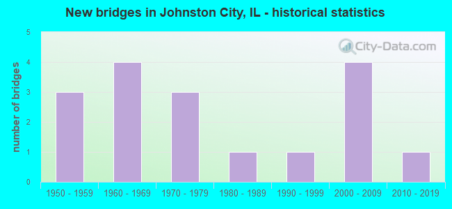
- New bridges - historical statistics
- 31950-1959
- 41960-1969
- 31970-1979
- 11980-1989
- 11990-1999
- 42000-2009
- 12010-2019


- Bridge Condition - Deck
- 38.5%Very good
- 15.4%Good
- 30.8%Satisfactory
- 15.4%Poor

- Bridge Condition - Superstructure
- 50.0%Very good
- 21.4%Good
- 7.1%Satisfactory
- 21.4%Fair

- Bridge Condition - Substructure
- 42.9%Very good
- 42.9%Good
- 7.1%Satisfactory
- 7.1%Fair

- Bridge Condition - Channel
- 53.8%Very good
- 15.4%Good
- 30.8%Satisfactory
Find on map >> Show street view
Structure Number: 100004, Location: AT WCL JOHNSTON CITY (Lat: 37.816669, Lng: -88.945736), Route carried "on" structure: County highway , Year Built: 1961, Status: Open, Structure Length: 7.25m (23.79ft), Average Daily Traffic: 6,500 (year 2021), Truck Traffic: 7%, Average Future Daily Traffic: 9,144 (year 2032), Design Load: HS 20, Features Intersected: INTERSTATE 57, Facility Carried by Structure: FAS 903 (CH 2)
Minimum Vertical Clearance: 30+ m (98+ ft), Kilometerpoint: 4.570, Lanes on structure: 2, Lanes under structure: 4, Base Highway Network: Yes, Owner: State Highway Agency, Approaching Roadway Width: 7.3m (24.0ft), Material/Design: Steel continuous, Design/Construction: Stringer/Multi-beam, Number Of Spans In Main Unit: 4, Length of Maximum Span: 23.0m (75.5ft), Curb-To-Curb Width: 9.0m (29.5ft), Out-to-Out Width: 10.9m (35.8ft)
Condition: Deck: Poor, Superstructure: Fair, Substructure: Satisfactory, Operating Rating: 46.3 metric tons, Method Used To Determine Operating Rating: Load Factor (LF) rating reported by rating factor (RF) method using MS18 loading, Inventory Rating: 27.9 metric tons, Method Used To Determine Inventory Rating: Load Factor (LF) rating reported by rating factor (RF) method using MS18 loading, Structural Evaluation: Somewhat better than minimum adequacy, Deck Geometry: Meets minimum limits, Underclear: Meets minimum limits, Approach Roadway Alignment: Equal to present desirable criteria, Length Of Structure Improvement: 7.25m (23.79ft), Designated Inspection Frequency: Every 24 months, Other Special Inspection Frequency: Every 48 months, Inspection Date: July 2021, Other Special Inspection Date: July 2021, Bridge Improvement Cost: $170,000, Roadway Improvement Cost: $9,000, Total Project Cost: $204,000, Deck Structure Type: Concrete Cast-file-Place, Wearing Surface/Protective System: Wearing Surface: Other
Find on map >> Show street view
Structure Number: 1000053, Location: 0.6 MI W OF ILL 37 (Lat: 37.839719, Lng: -88.944561), Route carried "on" structure: County highway , Year Built: 1961, Status: Open, Structure Length: 7.10m (23.29ft), Average Daily Traffic: 1,000 (year 2021), Truck Traffic: 23%, Average Future Daily Traffic: 1,029 (year 2032), Design Load: HS 15, Features Intersected: INTERSTATE 57, Facility Carried by Structure: TR 23 (STIRITZ RD)
Minimum Vertical Clearance: 30+ m (98+ ft), Kilometerpoint: 5.906, Lanes on structure: 2, Lanes under structure: 4, Owner: State Highway Agency, Approaching Roadway Width: 6.1m (20.0ft), Material/Design: Steel continuous, Design/Construction: Stringer/Multi-beam, Number Of Spans In Main Unit: 4, Length of Maximum Span: 23.0m (75.5ft), Curb or Sidewalk Widths: Left: 0.6m (2.0ft), Right: 0.6m (2.0ft), Curb-To-Curb Width: 7.9m (25.9ft), Out-to-Out Width: 9.7m (31.8ft)
Condition: Deck: Poor, Superstructure: Satisfactory, Substructure: Good, Operating Rating: 44.7 metric tons, Method Used To Determine Operating Rating: Load Factor (LF) rating reported by rating factor (RF) method using MS18 loading, Inventory Rating: 26.9 metric tons, Method Used To Determine Inventory Rating: Load Factor (LF) rating reported by rating factor (RF) method using MS18 loading, Structural Evaluation: Equal to present minimum criteria, Deck Geometry: Somewhat better than minimum adequacy, Underclear: Meets minimum limits, Approach Roadway Alignment: Equal to present desirable criteria, Length Of Structure Improvement: 7.10m (23.29ft), Designated Inspection Frequency: Every 24 months, Other Special Inspection Frequency: Every 48 months, Inspection Date: December 2021, Other Special Inspection Date: July 2021, Bridge Improvement Cost: $148,000, Roadway Improvement Cost: $7,000, Total Project Cost: $178,000, Deck Structure Type: Concrete Cast-file-Place
Find on map >> Show street view
Structure Number: 1000073, Location: 0.4 M S JHNSTON CITY (Lat: 37.807939, Lng: -88.932661), Route carried "on" structure: State highway 37, Year Built: 2000, Status: Open, Structure Length: 2.32m (7.61ft), Average Daily Traffic: 7,750 (year 2021), Truck Traffic: 8%, Average Future Daily Traffic: 8,515 (year 2032), Design Load: HS 20, Features Intersected: LAKE CREEK
Minimum Vertical Clearance: 30+ m (98+ ft), Kilometerpoint: 96.059, Lanes on structure: 2, Base Highway Network: Yes, Owner: State Highway Agency, Approaching Roadway Width: 10.4m (34.1ft), Material/Design: Steel, Design/Construction: Stringer/Multi-beam, Number Of Spans In Main Unit: 1, Length of Maximum Span: 21.9m (71.9ft), Curb-To-Curb Width: 12.0m (39.4ft), Out-to-Out Width: 13.0m (42.7ft)
Condition: Deck: Good, Superstructure: Very good, Substructure: Very good, Channel: Very good, Operating Rating: 87.8 metric tons, Method Used To Determine Operating Rating: Load Factor (LF) rating reported by rating factor (RF) method using MS18 loading, Inventory Rating: 52.8 metric tons, Method Used To Determine Inventory Rating: Load Factor (LF) rating reported by rating factor (RF) method using MS18 loading, Structural Evaluation: Equal to present desirable criteria, Deck Geometry: Somewhat better than minimum adequacy, Waterway Adequacy: Equal to present desirable criteria, Approach Roadway Alignment: Equal to present desirable criteria, Designated Inspection Frequency: Every 48 months, Inspection Date: March 2018, Deck Structure Type: Concrete Cast-file-Place, Wearing Surface/Protective System: Deck Protection: Epoxy Coated Reinforcing
Find on map >> Show street view
Structure Number: 1000078, Location: 0.3 MI S JOHNSTON C (Lat: 37.812356, Lng: -88.945736), Route carried "on" structure: Interstate 57, Year Built: 2005, Status: Open, Structure Length: 4.75m (15.58ft), Average Daily Traffic: 21,200 (year 2021), Truck Traffic: 40%, Average Future Daily Traffic: 18,117 (year 2032), Design Load: HS 20+Mod, Features Intersected: LAKE CREEK
Minimum Vertical Clearance: 30+ m (98+ ft), Kilometerpoint: 94.418, Lanes on structure: 2, Base Highway Network: Yes, Owner: State Highway Agency, Approaching Roadway Width: 19.9m (65.3ft), Skew: 2 degrees, Material/Design: Steel continuous, Design/Construction: Stringer/Multi-beam, Number Of Spans In Main Unit: 3, Length of Maximum Span: 17.1m (56.1ft), Curb-To-Curb Width: 24.9m (81.7ft), Out-to-Out Width: 25.8m (84.6ft)
Condition: Deck: Satisfactory, Superstructure: Good, Substructure: Good, Channel: Good, Operating Rating: 89.1 metric tons, Method Used To Determine Operating Rating: Load Factor (LF) rating reported by rating factor (RF) method using MS18 loading, Inventory Rating: 68.0 metric tons, Method Used To Determine Inventory Rating: Load Factor (LF) rating reported by rating factor (RF) method using MS18 loading, Structural Evaluation: Better than present minimum criteria, Deck Geometry: Superior to present desirable criteria, Waterway Adequacy: Equal to present desirable criteria, Approach Roadway Alignment: Equal to present desirable criteria, Designated Inspection Frequency: Every 24 months, Inspection Date: August 2021, Deck Structure Type: Concrete Cast-file-Place, Wearing Surface/Protective System: Deck Protection: Epoxy Coated Reinforcing
Find on map >> Show street view
Structure Number: 1000079, Location: 0.3 MI S JOHNSTON C (Lat: 37.812789, Lng: -88.945744), Route carried "on" structure: Interstate 57, Year Built: 2005, Status: Open, Structure Length: 4.75m (15.58ft), Average Daily Traffic: 21,200 (year 2021), Truck Traffic: 40%, Average Future Daily Traffic: 18,117 (year 2032), Design Load: HS 20+Mod, Features Intersected: LAKE CREEK
Minimum Vertical Clearance: 30+ m (98+ ft), Kilometerpoint: 94.466, Lanes on structure: 2, Base Highway Network: Yes, Owner: State Highway Agency, Approaching Roadway Width: 17.1m (56.1ft), Skew: 2 degrees, Material/Design: Steel continuous, Design/Construction: Stringer/Multi-beam, Number Of Spans In Main Unit: 3, Length of Maximum Span: 17.1m (56.1ft), Curb-To-Curb Width: 23.8m (78.1ft), Out-to-Out Width: 24.7m (81.0ft)
Condition: Deck: Satisfactory, Superstructure: Very good, Substructure: Good, Channel: Very good, Operating Rating: 89.1 metric tons, Method Used To Determine Operating Rating: Load Factor (LF) rating reported by rating factor (RF) method using MS18 loading, Inventory Rating: 67.7 metric tons, Method Used To Determine Inventory Rating: Load Factor (LF) rating reported by rating factor (RF) method using MS18 loading, Structural Evaluation: Better than present minimum criteria, Deck Geometry: Superior to present desirable criteria, Waterway Adequacy: Equal to present desirable criteria, Approach Roadway Alignment: Equal to present desirable criteria, Designated Inspection Frequency: Every 24 months, Inspection Date: August 2021, Deck Structure Type: Concrete Cast-file-Place, Wearing Surface/Protective System: Deck Protection: Epoxy Coated Reinforcing
Find on map >> Show street view
Structure Number: 1002017, Location: 0.3MI S JHNSTON CITY (Lat: 37.810289, Lng: -88.932667), Route carried "on" structure: State highway 37, Year Built: 2002, Status: Open, Structure Length: 1.98m (6.50ft), Average Daily Traffic: 7,750 (year 2021), Truck Traffic: 8%, Average Future Daily Traffic: 8,515 (year 2032), Design Load: HS 20, Features Intersected: LAKE CREEK OVERFLOW
Minimum Vertical Clearance: 30+ m (98+ ft), Kilometerpoint: 96.317, Lanes on structure: 2, Base Highway Network: Yes, Owner: State Highway Agency, Approaching Roadway Width: 9.8m (32.2ft), Material/Design: Concrete, Design/Construction: Frame, Number Of Spans In Main Unit: 2, Length of Maximum Span: 9.7m (31.8ft), Curb-To-Curb Width: 9.8m (32.2ft), Out-to-Out Width: 18.9m (62.0ft)
Condition: Superstructure: Good, Substructure: Good, Channel: Very good, Operating Rating: 44.1 metric tons, Method Used To Determine Operating Rating: Load Factor (LF) rating reported by rating factor (RF) method using MS18 loading, Inventory Rating: 32.4 metric tons, Method Used To Determine Inventory Rating: Load Factor (LF) rating reported by rating factor (RF) method using MS18 loading, Structural Evaluation: Better than present minimum criteria, Deck Geometry: Meets minimum limits, Waterway Adequacy: Superior to present desirable criteria, Approach Roadway Alignment: Equal to present desirable criteria, Designated Inspection Frequency: Every 48 months, Inspection Date: January 2021
Find on map >> Show street view
Structure Number: 100301, Location: 2 MI W JOHNSON CITY (Lat: 37.817392, Lng: -88.971856), Route carried "on" structure: County highway , Year Built: 1956, Status: Open, Structure Length: 2.30m (7.55ft), Average Daily Traffic: 6,000 (year 2021), Truck Traffic: 7%, Average Future Daily Traffic: 8,115 (year 2032), Design Load: HS 15, Features Intersected: BEAR CREEK, Facility Carried by Structure: FAS 903 (UNMARKED)
Minimum Vertical Clearance: 30+ m (98+ ft), Kilometerpoint: 2.333, Lanes on structure: 2, Base Highway Network: Yes, Owner: State Highway Agency, Approaching Roadway Width: 11.0m (36.1ft), Material/Design: Steel continuous, Design/Construction: Stringer/Multi-beam, Number Of Spans In Main Unit: 3, Length of Maximum Span: 8.5m (27.9ft), Curb-To-Curb Width: 7.9m (25.9ft), Out-to-Out Width: 10.0m (32.8ft)
Condition: Deck: Satisfactory, Superstructure: Fair, Substructure: Fair, Channel: Satisfactory, Operating Rating: 39.5 metric tons, Method Used To Determine Operating Rating: Allowable Stress (AS) rating reported by rating factor (RF) method using MS18 loading, Inventory Rating: 24.9 metric tons, Method Used To Determine Inventory Rating: Allowable Stress (AS) rating reported by rating factor (RF) method using MS18 loading, Structural Evaluation: Somewhat better than minimum adequacy, Deck Geometry: High priority of replacement, Waterway Adequacy: Better than present minimum criteria, Approach Roadway Alignment: Equal to present desirable criteria, Length Of Structure Improvement: 2.99m (9.81ft), Designated Inspection Frequency: Every 24 months, Inspection Date: November 2021, Bridge Improvement Cost: $324,000, Roadway Improvement Cost: $32,000, Total Project Cost: $486,000, Deck Structure Type: Concrete Cast-file-Place, Wearing Surface/Protective System: Wearing Surface: Bituminous
Find on map >> Show street view
Structure Number: 1003011, Location: 1 MI W JOHNSON CITY (Lat: 37.817408, Lng: -88.963819), Route carried "on" structure: County highway , Year Built: 1956, Status: Open, Structure Length: 6.92m (22.70ft), Average Daily Traffic: 6,000 (year 2021), Truck Traffic: 7%, Average Future Daily Traffic: 8,115 (year 2032), Design Load: HS 15, Features Intersected: LAKE CREEK, Facility Carried by Structure: FAS 903 (UNMARKED)
Minimum Vertical Clearance: 30+ m (98+ ft), Kilometerpoint: 3.042, Lanes on structure: 2, Base Highway Network: Yes, Owner: State Highway Agency, Approaching Roadway Width: 9.1m (29.9ft), Material/Design: Steel continuous, Design/Construction: Stringer/Multi-beam, Number Of Spans In Main Unit: 3, Length of Maximum Span: 26.2m (86.0ft), Curb-To-Curb Width: 8.2m (26.9ft), Out-to-Out Width: 9.1m (29.9ft)
Condition: Deck: Satisfactory, Superstructure: Fair, Substructure: Good, Channel: Satisfactory, Operating Rating: 46.7 metric tons, Method Used To Determine Operating Rating: Load Factor (LF) rating reported by rating factor (RF) method using MS18 loading, Inventory Rating: 25.6 metric tons, Method Used To Determine Inventory Rating: Load Factor (LF) rating reported by rating factor (RF) method using MS18 loading, Structural Evaluation: Somewhat better than minimum adequacy, Deck Geometry: High priority of corrective action, Waterway Adequacy: Equal to present desirable criteria, Approach Roadway Alignment: Equal to present desirable criteria, Length Of Structure Improvement: 7.62m (25.00ft), Designated Inspection Frequency: Every 24 months, Inspection Date: November 2021, Bridge Improvement Cost: $899,000, Roadway Improvement Cost: $90,000, Total Project Cost: $1,349,000, Deck Structure Type: Concrete Cast-file-Place, Wearing Surface/Protective System: Wearing Surface: Bituminous
Find on map >> Show street view
Structure Number: 10031, Location: .5 MI S JOHNSTON CTY (Lat: 37.807922, Lng: -88.928086), Route carried "on" structure: County highway , Year Built: 1978, Status: Open, Structure Length: 3.54m (11.61ft), Average Daily Traffic: 325 (year 2021), Truck Traffic: 19%, Average Future Daily Traffic: 457 (year 2032), Design Load: HS 20, Features Intersected: LAKE CREEK, Facility Carried by Structure: TR 350
Minimum Vertical Clearance: 30+ m (98+ ft), Kilometerpoint: 0.290, Lanes on structure: 2, Owner: Town or Township Highway Agency, Approaching Roadway Width: 5.5m (18.0ft), Material/Design: Concrete, Design/Construction: Channel Beam, Number Of Spans In Main Unit: 3, Length of Maximum Span: 11.6m (38.1ft), Curb-To-Curb Width: 6.5m (21.3ft), Out-to-Out Width: 6.8m (22.3ft)
Condition: Deck: Good, Superstructure: Good, Substructure: Very good, Channel: Good, Operating Rating: 44.4 metric tons, Method Used To Determine Operating Rating: Load Factor (LF) rating reported by rating factor (RF) method using MS18 loading, Inventory Rating: 26.6 metric tons, Method Used To Determine Inventory Rating: Load Factor (LF) rating reported by rating factor (RF) method using MS18 loading, Structural Evaluation: Equal to present minimum criteria, Deck Geometry: Meets minimum limits, Waterway Adequacy: Equal to present desirable criteria, Approach Roadway Alignment: Better than present minimum criteria, Length Of Structure Improvement: 4.45m (14.60ft), Designated Inspection Frequency: Every 24 months, Inspection Date: April 2021, Bridge Improvement Cost: $260,000, Roadway Improvement Cost: $26,000, Total Project Cost: $286,000, Deck Structure Type: Concrete Precast Panels, Wearing Surface/Protective System: Wearing Surface: Bituminous
Find on map >> Show street view
Structure Number: 1003102, Location: .2 MI E JOHNSTON CIT (Lat: 37.819139, Lng: -88.910144), Route carried "on" structure: County highway , Year Built: 1980, Status: Open, Structure Length: 2.99m (9.81ft), Average Daily Traffic: 450 (year 2021), Truck Traffic: 12%, Average Future Daily Traffic: 800 (year 2032), Design Load: HS 20, Features Intersected: LAKE CREEK, Facility Carried by Structure: CH 14
Minimum Vertical Clearance: 30+ m (98+ ft), Kilometerpoint: 0.338, Lanes on structure: 2, Owner: County Highway Agency, Approaching Roadway Width: 7.9m (25.9ft), Material/Design: Concrete, Design/Construction: Slab, Number Of Spans In Main Unit: 3, Length of Maximum Span: 9.8m (32.2ft), Curb-To-Curb Width: 9.1m (29.9ft), Out-to-Out Width: 9.2m (30.2ft)
Condition: Deck: Very good, Superstructure: Very good, Substructure: Very good, Channel: Very good, Operating Rating: 44.4 metric tons, Method Used To Determine Operating Rating: Assigned rating based on Load Factor Design (LFD) reported by rating factor (RF) using MS18 loading, Inventory Rating: 32.4 metric tons, Method Used To Determine Inventory Rating: Assigned rating based on Load Factor Design (LFD) reported by rating factor (RF) using MS18 loading, Structural Evaluation: Equal to present desirable criteria, Deck Geometry: Equal to present minimum criteria, Waterway Adequacy: Equal to present desirable criteria, Approach Roadway Alignment: Equal to present desirable criteria, Designated Inspection Frequency: Every 48 months, Inspection Date: September 2019, Deck Structure Type: Concrete Cast-file-Place, Wearing Surface/Protective System: Wearing Surface: Bituminous
Find on map >> Show street view
Structure Number: 1003103, Location: SW CORP LIM J CITY (Lat: 37.813650, Lng: -88.942064), Route carried "on" structure: County highway , Year Built: 1979, Status: Open, Structure Length: 3.78m (12.40ft), Average Daily Traffic: 600 (year 2021), Truck Traffic: 16%, Average Future Daily Traffic: 857 (year 2032), Design Load: HS 20, Features Intersected: LAKE CREEKOVERFLOW, Facility Carried by Structure: CH 1
Minimum Vertical Clearance: 30+ m (98+ ft), Kilometerpoint: 0.338, Lanes on structure: 2, Owner: County Highway Agency, Approaching Roadway Width: 10.4m (34.1ft), Material/Design: Prestressed concrete, Design/Construction: Box Beam or Girders - Multiple, Number Of Spans In Main Unit: 1, Number Of Approach Spans: 2, Length of Maximum Span: 15.2m (49.9ft), Curb-To-Curb Width: 9.1m (29.9ft), Out-to-Out Width: 9.3m (30.5ft)
Condition: Deck: Very good, Superstructure: Very good, Substructure: Very good, Channel: Very good, Operating Rating: 44.4 metric tons, Method Used To Determine Operating Rating: Assigned rating based on Load Factor Design (LFD) reported by rating factor (RF) using MS18 loading, Inventory Rating: 32.4 metric tons, Method Used To Determine Inventory Rating: Assigned rating based on Load Factor Design (LFD) reported by rating factor (RF) using MS18 loading, Structural Evaluation: Equal to present desirable criteria, Deck Geometry: Equal to present minimum criteria, Waterway Adequacy: Equal to present desirable criteria, Approach Roadway Alignment: Equal to present desirable criteria, Designated Inspection Frequency: Every 48 months, Inspection Date: September 2019, Deck Structure Type: Concrete Precast Panels, Wearing Surface/Protective System: Wearing Surface: Bituminous
Find on map >> Show street view
Structure Number: 1003104, Location: .5 MI SW JOHNSTON CY (Lat: 37.811781, Lng: -88.942017), Route carried "on" structure: County highway , Year Built: 1979, Status: Open, Structure Length: 1.37m (4.49ft), Average Daily Traffic: 600 (year 2021), Truck Traffic: 16%, Average Future Daily Traffic: 857 (year 2032), Design Load: HS 20, Features Intersected: LAKE CREEK, Facility Carried by Structure: CH 1
Minimum Vertical Clearance: 30+ m (98+ ft), Kilometerpoint: 0.547, Lanes on structure: 2, Owner: County Highway Agency, Approaching Roadway Width: 10.4m (34.1ft), Material/Design: Prestressed concrete, Design/Construction: Box Beam or Girders - Multiple, Number Of Spans In Main Unit: 1, Length of Maximum Span: 13.1m (43.0ft), Curb-To-Curb Width: 9.1m (29.9ft), Out-to-Out Width: 9.3m (30.5ft)
Condition: Deck: Very good, Superstructure: Very good, Substructure: Good, Channel: Satisfactory, Operating Rating: 44.4 metric tons, Method Used To Determine Operating Rating: Assigned rating based on Load Factor Design (LFD) reported by rating factor (RF) using MS18 loading, Inventory Rating: 32.4 metric tons, Method Used To Determine Inventory Rating: Assigned rating based on Load Factor Design (LFD) reported by rating factor (RF) using MS18 loading, Structural Evaluation: Better than present minimum criteria, Deck Geometry: Equal to present minimum criteria, Waterway Adequacy: Equal to present desirable criteria, Approach Roadway Alignment: Equal to present desirable criteria, Designated Inspection Frequency: Every 48 months, Inspection Date: September 2019, Deck Structure Type: Concrete Precast Panels, Wearing Surface/Protective System: Wearing Surface: Bituminous
Find on map >> Show street view
Structure Number: 1003159, Location: 3 MI NE JHNSTON CITY (Lat: 37.845961, Lng: -88.858344), Route carried "on" structure: County highway , Year Built: 1998, Status: Open, Structure Length: 1.11m (3.64ft), Average Daily Traffic: 150 (year 2021), Truck Traffic: 27%, Average Future Daily Traffic: 200 (year 2032), Design Load: HS 20, Features Intersected: POND CREEK TRIB, Facility Carried by Structure: TR 29-DEAN ROAD
Minimum Vertical Clearance: 30+ m (98+ ft), Kilometerpoint: 1.464, Lanes on structure: 2, Owner: Town or Township Highway Agency, Approaching Roadway Width: 5.5m (18.0ft), Material/Design: Prestressed concrete, Design/Construction: Box Beam or Girders - Multiple, Number Of Spans In Main Unit: 1, Length of Maximum Span: 10.4m (34.1ft), Curb-To-Curb Width: 7.4m (24.3ft), Out-to-Out Width: 7.4m (24.3ft)
Condition: Deck: Very good, Superstructure: Very good, Substructure: Very good, Channel: Very good, Operating Rating: 44.1 metric tons, Method Used To Determine Operating Rating: Assigned rating based on Load Factor Design (LFD) reported by rating factor (RF) using MS18 loading, Inventory Rating: 32.4 metric tons, Method Used To Determine Inventory Rating: Assigned rating based on Load Factor Design (LFD) reported by rating factor (RF) using MS18 loading, Structural Evaluation: Equal to present desirable criteria, Deck Geometry: Somewhat better than minimum adequacy, Waterway Adequacy: Equal to present desirable criteria, Approach Roadway Alignment: Equal to present desirable criteria, Designated Inspection Frequency: Every 48 months, Inspection Date: August 2019, Deck Structure Type: Concrete Precast Panels
Find on map >> Show street view
Structure Number: 1003186, Location: 1 MI NE JOHNSTON CIT (Lat: 37.841917, Lng: -88.884008), Route carried "on" structure: County highway , Year Built: 2019, Status: Open, Structure Length: 1.88m (6.17ft), Average Daily Traffic: 225 (year 2021), Truck Traffic: 22%, Average Future Daily Traffic: 650 (year 2041), Design Load: HS 25 or greater, Features Intersected: CREEK, Facility Carried by Structure: GERMAN CHURCH RD
Minimum Vertical Clearance: 30+ m (98+ ft), Kilometerpoint: 3.524, Lanes on structure: 2, Owner: Town or Township Highway Agency, Approaching Roadway Width: 5.5m (18.0ft), Material/Design: Prestressed concrete, Design/Construction: Box Beam or Girders - Multiple, Number Of Spans In Main Unit: 1, Length of Maximum Span: 18.0m (59.1ft), Curb-To-Curb Width: 7.4m (24.3ft), Out-to-Out Width: 7.4m (24.3ft)
Condition: Deck: Very good, Superstructure: Very good, Substructure: Very good, Channel: Very good, Operating Rating: 56.4 metric tons, Method Used To Determine Operating Rating: Load and Resistance Factor Rating (LRFR) rating reported by rating factor(RF) method using HL-93 loadings, Inventory Rating: 43.7 metric tons, Method Used To Determine Inventory Rating: Load and Resistance Factor Rating (LRFR) rating reported by rating factor(RF) method using HL-93 loadings, Structural Evaluation: Equal to present desirable criteria, Deck Geometry: Somewhat better than minimum adequacy, Waterway Adequacy: Equal to present desirable criteria, Approach Roadway Alignment: Equal to present desirable criteria, Designated Inspection Frequency: Every 48 months, Inspection Date: June 2021, Deck Structure Type: Concrete Precast Panels
Find on map >> Show street view
Structure Number: 1005002, Location: 0.7 M W JOHNSTON CIT (Lat: 37.817572, Lng: -88.955892), Route carried "on" structure: City street , Year Built: 1956, Status: Posted for load, Structure Length: 0.79m (2.59ft), Average Daily Traffic: 800 (year 2021), Truck Traffic: 23%, Average Future Daily Traffic: 1,086 (year 2032), Design Load: HS 15, Features Intersected: DRAINAGE DITCH, Facility Carried by Structure: CS 7000 OFF FAS 90
Minimum Vertical Clearance: 30+ m (98+ ft), Kilometerpoint: 0.290, Lanes on structure: 2, Owner: State Highway Agency, Approaching Roadway Width: 9.1m (29.9ft), Material/Design: Concrete continuous, Design/Construction: Culvert, Number Of Spans In Main Unit: 2, Length of Maximum Span: 3.7m (12.1ft), Curb-To-Curb Width: 7.2m (23.6ft), Out-to-Out Width: 7.7m (25.3ft)
Condition: Channel: Satisfactory, Culverts: Satisfactory, Operating Rating: 32.7 metric tons, Method Used To Determine Operating Rating: Load Factor (LF) rating reported by rating factor (RF) method using MS18 loading, Inventory Rating: 19.8 metric tons, Method Used To Determine Inventory Rating: Load Factor (LF) rating reported by rating factor (RF) method using MS18 loading, Structural Evaluation: Somewhat better than minimum adequacy, Deck Geometry: Meets minimum limits, Waterway Adequacy: Equal to present desirable criteria, Approach Roadway Alignment: Equal to present desirable criteria, Bridge Posting: Required (Relationship of Operating Rating to Maximum Legal Load: 30.0 - 39.9% below), Length Of Structure Improvement: 0.91m (2.99ft), Designated Inspection Frequency: Every 12 months, Inspection Date: November 2021, Bridge Improvement Cost: $75,000, Roadway Improvement Cost: $25,000, Total Project Cost: $100,000, Deck Structure Type: Concrete Cast-file-Place
Find on map >> Show street view
Structure Number: 100004, Location: AT WCL JOHNSTON CITY (Lat: 37.816669, Lng: -88.945736), Route carried "under" structure: Interstate 57, Year Built: 1961, Structure Length: 0. m, Average Daily Traffic: 35,600 (year 2020), Truck Traffic: 34%, Features Intersected: INTERSTATE 57, Facility Carried by Structure: FAS 903 (CH 2)
Minimum Vertical Clearance: 5.05m (16.57ft), Kilometerpoint: 94.884, Lanes on structure: 2, Lanes under structure: 4, Material/Design: Steel continuous, Design/Construction: Stringer/Multi-beam, Length of Maximum Span: 23.0m (75.5ft)
Find on map >> Show street view
Structure Number: 1000053, Location: 0.6 MI W OF ILL 37 (Lat: 37.839731, Lng: -88.944200), Route carried "under" structure: Interstate 57, Year Built: 1961, Structure Length: 0. m, Average Daily Traffic: 35,600 (year 2020), Truck Traffic: 34%, Features Intersected: INTERSTATE 57, Facility Carried by Structure: TR 23 (STIRITZ RD)
Minimum Vertical Clearance: 4.93m (16.17ft), Kilometerpoint: 97.443, Lanes on structure: 2, Lanes under structure: 4, Material/Design: Steel continuous, Design/Construction: Stringer/Multi-beam, Length of Maximum Span: 23.0m (75.5ft)