Bridge Statistics for Julesburg, Colorado (CO)
Condition, Traffic, Stress, Structural Evaluation, Project Costs
- National Bridge Inventory (NBI) Statistics
- 18Number of bridges
- 266ft / 80.9mTotal length
- 56,779Total average daily traffic
- 11,379Total average daily truck traffic
- National Bridge Inventory (NBI) Registered Bridges for Julesburg
- No street view available for this location
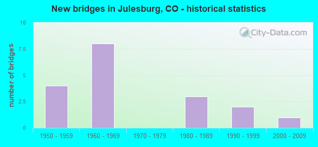
- New bridges - historical statistics
- 41950-1959
- 81960-1969
- 31980-1989
- 21990-1999
- 12000-2009


- Bridge Condition - Deck
- 8.3%Very good
- 41.7%Good
- 50.0%Satisfactory

- Bridge Condition - Superstructure
- 8.3%Very good
- 58.3%Good
- 16.7%Satisfactory
- 16.7%Fair

- Bridge Condition - Substructure
- 8.3%Very good
- 58.3%Good
- 33.3%Fair

- Bridge Condition - Channel
- 37.5%Very good
- 37.5%Good
- 25.0%Satisfactory
Find on map >> Show street view
Structure Number: A-27-P, Location: 2 MI W OF JULESBURG (Lat: 40.979369, Lng: -102.315600), Route carried "on" structure: US 138A, Year Built: 2000, Status: Open, Structure Length: 8.06m (26.44ft), Average Daily Traffic: 1,300 (year 2020), Truck Traffic: 11%, Average Future Daily Traffic: 1,456 (year 2040), Design Load: HS 25 or greater, Features Intersected: UP RR, Facility Carried by Structure: US 138 ML
Minimum Vertical Clearance: 30+ m (98+ ft), Kilometerpoint: 88.376, Lanes on structure: 2, Base Highway Network: Yes, Owner: State Highway Agency, Approaching Roadway Width: 12.8m (42.0ft), Skew: 3 degrees, Material/Design: Prestressed concrete continuous, Design/Construction: Box Beam or Girders - Single/Spread, Number Of Spans In Main Unit: 3, Length of Maximum Span: 31.6m (103.7ft), Curb-To-Curb Width: 12.0m (39.4ft), Out-to-Out Width: 12.9m (42.3ft)
Condition: Deck: Good, Superstructure: Good, Substructure: Good, Operating Rating: 96.7 metric tons, Method Used To Determine Operating Rating: Load Factor (LF), Inventory Rating: 57.9 metric tons, Method Used To Determine Inventory Rating: Load Factor (LF), Structural Evaluation: Better than present minimum criteria, Deck Geometry: Equal to present minimum criteria, Underclear: Superior to present desirable criteria, Approach Roadway Alignment: Equal to present desirable criteria, Designated Inspection Frequency: Every 24 months, Inspection Date: March 2021, Deck Structure Type: Concrete Cast-file-Place, Wearing Surface/Protective System: Wearing Surface: Bituminous, Membrane: Built-up, Deck Protection: Epoxy Coated Reinforcing
Find on map >> Show street view
Structure Number: A-28-M, Location: 0.8 MI N OF I 76 (Lat: 40.978458, Lng: -102.254964), Route carried "on" structure: US 385D, Year Built: 1956, Status: Open, Structure Length: 6.57m (21.56ft), Average Daily Traffic: 1,600 (year 2018), Truck Traffic: 13%, Average Future Daily Traffic: 2,192 (year 2038), Design Load: HS 20+Mod, Features Intersected: SOUTH PLATTE RIVER, Facility Carried by Structure: US 385 ML
Minimum Vertical Clearance: 30+ m (98+ ft), Kilometerpoint: 146.177, Lanes on structure: 2, Base Highway Network: Yes, Owner: State Highway Agency, Approaching Roadway Width: 8.5m (27.9ft), Material/Design: Concrete, Design/Construction: Tee Beam, Number Of Spans In Main Unit: 6, Length of Maximum Span: 10.7m (35.1ft), Curb-To-Curb Width: 8.5m (27.9ft), Out-to-Out Width: 9.8m (32.2ft)
Condition: Deck: Satisfactory, Superstructure: Satisfactory, Substructure: Fair, Channel: Satisfactory, Operating Rating: 70.9 metric tons, Method Used To Determine Operating Rating: Load Factor (LF), Inventory Rating: 42.5 metric tons, Method Used To Determine Inventory Rating: Load Factor (LF), Structural Evaluation: Somewhat better than minimum adequacy, Deck Geometry: Somewhat better than minimum adequacy, Waterway Adequacy: Equal to present desirable criteria, Approach Roadway Alignment: Equal to present desirable criteria, Length Of Structure Improvement: 6.55m (21.49ft), Designated Inspection Frequency: Every 24 months, Inspection Date: March 2021, Deck Structure Type: Other, Wearing Surface/Protective System: Wearing Surface: Bituminous
Find on map >> Show street view
Structure Number: A-28-N, Location: 0.7 MI N OF JCT I 76 (Lat: 40.976850, Lng: -102.253758), Route carried "on" structure: US 385D, Year Built: 1956, Status: Open, Structure Length: 6.57m (21.56ft), Average Daily Traffic: 1,600 (year 2018), Truck Traffic: 13%, Average Future Daily Traffic: 2,192 (year 2038), Design Load: HS 20+Mod, Features Intersected: SOUTH PLATTE RIVER, Facility Carried by Structure: US 385 ML
Minimum Vertical Clearance: 30+ m (98+ ft), Kilometerpoint: 145.971, Lanes on structure: 2, Base Highway Network: Yes, Owner: State Highway Agency, Approaching Roadway Width: 8.5m (27.9ft), Material/Design: Concrete, Design/Construction: Tee Beam, Number Of Spans In Main Unit: 6, Length of Maximum Span: 10.7m (35.1ft), Curb-To-Curb Width: 8.5m (27.9ft), Out-to-Out Width: 9.8m (32.2ft)
Condition: Deck: Satisfactory, Superstructure: Fair, Substructure: Fair, Channel: Satisfactory, Operating Rating: 70.9 metric tons, Method Used To Determine Operating Rating: Load Factor (LF), Inventory Rating: 42.5 metric tons, Method Used To Determine Inventory Rating: Load Factor (LF), Structural Evaluation: Somewhat better than minimum adequacy, Deck Geometry: Somewhat better than minimum adequacy, Waterway Adequacy: Equal to present desirable criteria, Approach Roadway Alignment: Equal to present desirable criteria, Designated Inspection Frequency: Every 24 months, Inspection Date: March 2021, Deck Structure Type: Other, Wearing Surface/Protective System: Wearing Surface: Bituminous
Find on map >> Show street view
Structure Number: A-28-O, Location: 0.6 MI N OF JCT I76 (Lat: 40.974494, Lng: -102.251997), Route carried "on" structure: US 385D, Year Built: 1956, Status: Open, Structure Length: 16.37m (53.71ft), Average Daily Traffic: 1,600 (year 2018), Truck Traffic: 13%, Average Future Daily Traffic: 2,192 (year 2038), Design Load: HS 20+Mod, Features Intersected: SOUTH PLATTE RIVER, Facility Carried by Structure: US 385 ML
Minimum Vertical Clearance: 30+ m (98+ ft), Kilometerpoint: 145.670, Lanes on structure: 2, Base Highway Network: Yes, Owner: State Highway Agency, Approaching Roadway Width: 8.5m (27.9ft), Material/Design: Concrete, Design/Construction: Tee Beam, Number Of Spans In Main Unit: 15, Length of Maximum Span: 10.7m (35.1ft), Curb-To-Curb Width: 8.5m (27.9ft), Out-to-Out Width: 9.8m (32.2ft)
Condition: Deck: Satisfactory, Superstructure: Fair, Substructure: Fair, Channel: Good, Operating Rating: 68.4 metric tons, Method Used To Determine Operating Rating: Load Factor (LF), Inventory Rating: 40.9 metric tons, Method Used To Determine Inventory Rating: Load Factor (LF), Structural Evaluation: Somewhat better than minimum adequacy, Deck Geometry: Somewhat better than minimum adequacy, Waterway Adequacy: Equal to present desirable criteria, Approach Roadway Alignment: Equal to present desirable criteria, Designated Inspection Frequency: Every 24 months, Inspection Date: March 2021, Deck Structure Type: Other, Wearing Surface/Protective System: Wearing Surface: Bituminous
Find on map >> Show street view
Structure Number: A-28-P, Location: 0.4 MI N OF JCT I 76 (Lat: 40.972806, Lng: -102.250736), Route carried "on" structure: US 385D, Year Built: 1956, Status: Open, Structure Length: 8.74m (28.67ft), Average Daily Traffic: 1,600 (year 2018), Truck Traffic: 13%, Average Future Daily Traffic: 2,192 (year 2038), Design Load: HS 20+Mod, Features Intersected: SOUTH PLATTE RIVER, Facility Carried by Structure: US 385 ML
Minimum Vertical Clearance: 30+ m (98+ ft), Kilometerpoint: 145.454, Lanes on structure: 2, Base Highway Network: Yes, Owner: State Highway Agency, Approaching Roadway Width: 8.5m (27.9ft), Material/Design: Concrete, Design/Construction: Tee Beam, Number Of Spans In Main Unit: 8, Length of Maximum Span: 10.7m (35.1ft), Curb-To-Curb Width: 8.5m (27.9ft), Out-to-Out Width: 9.8m (32.2ft)
Condition: Deck: Satisfactory, Superstructure: Satisfactory, Substructure: Fair, Channel: Good, Operating Rating: 70.9 metric tons, Method Used To Determine Operating Rating: Load Factor (LF), Inventory Rating: 42.5 metric tons, Method Used To Determine Inventory Rating: Load Factor (LF), Structural Evaluation: Somewhat better than minimum adequacy, Deck Geometry: Somewhat better than minimum adequacy, Waterway Adequacy: Equal to present desirable criteria, Approach Roadway Alignment: Equal to present desirable criteria, Designated Inspection Frequency: Every 24 months, Inspection Date: March 2021, Deck Structure Type: Other, Wearing Surface/Protective System: Wearing Surface: Bituminous
Find on map >> Show street view
Structure Number: A-28-Q, Location: 3.9 MI SW OF NEBRASKA S.L (Lat: 40.967983, Lng: -102.247517), Route carried "on" structure: Interstate 76A, Year Built: 1969, Status: Open, Structure Length: 4.66m (15.29ft), Average Daily Traffic: 3,600 (year 2020), Truck Traffic: 29%, Average Future Daily Traffic: 4,284 (year 2040), Design Load: HS 20+Mod, Features Intersected: US 385 ML, Facility Carried by Structure: I 76 ML WBND
Minimum Vertical Clearance: 30+ m (98+ ft), Kilometerpoint: 289.883, Lanes on structure: 2, Lanes under structure: 2, Base Highway Network: Yes, Owner: State Highway Agency, Approaching Roadway Width: 11.6m (38.1ft), Skew: 11 degrees, Material/Design: Concrete continuous, Design/Construction: Tee Beam, Number Of Spans In Main Unit: 3, Length of Maximum Span: 18.6m (61.0ft), Curb-To-Curb Width: 12.8m (42.0ft), Out-to-Out Width: 13.6m (44.6ft)
Condition: Deck: Satisfactory, Superstructure: Good, Substructure: Good, Operating Rating: 50.8 metric tons, Method Used To Determine Operating Rating: Load Factor (LF), Inventory Rating: 30.5 metric tons, Method Used To Determine Inventory Rating: Load Factor (LF), Structural Evaluation: Better than present minimum criteria, Deck Geometry: Equal to present desirable criteria, Underclear: Equal to present minimum criteria, Approach Roadway Alignment: Equal to present desirable criteria, Designated Inspection Frequency: Every 24 months, Inspection Date: May 2021, Deck Structure Type: Other, Wearing Surface/Protective System: Wearing Surface: Bituminous, Membrane: Built-up
Find on map >> Show street view
Structure Number: A-28-R, Location: JULESBURG INTERCHANGE (Lat: 40.967658, Lng: -102.247264), Route carried "on" structure: Interstate 76A, Year Built: 1969, Status: Open, Structure Length: 4.67m (15.32ft), Average Daily Traffic: 3,600 (year 2020), Truck Traffic: 29%, Average Future Daily Traffic: 4,284 (year 2040), Design Load: HS 20+Mod, Features Intersected: US 385 ML, Facility Carried by Structure: I 76 ML EBND
Minimum Vertical Clearance: 30+ m (98+ ft), Kilometerpoint: 289.870, Lanes on structure: 2, Lanes under structure: 2, Base Highway Network: Yes, Owner: State Highway Agency, Approaching Roadway Width: 11.6m (38.1ft), Skew: 11 degrees, Material/Design: Concrete continuous, Design/Construction: Tee Beam, Number Of Spans In Main Unit: 3, Length of Maximum Span: 18.6m (61.0ft), Curb-To-Curb Width: 12.8m (42.0ft), Out-to-Out Width: 13.6m (44.6ft)
Condition: Deck: Good, Superstructure: Good, Substructure: Good, Operating Rating: 50.8 metric tons, Method Used To Determine Operating Rating: Load Factor (LF), Inventory Rating: 30.5 metric tons, Method Used To Determine Inventory Rating: Load Factor (LF), Structural Evaluation: Better than present minimum criteria, Deck Geometry: Equal to present desirable criteria, Underclear: Somewhat better than minimum adequacy, Approach Roadway Alignment: Equal to present desirable criteria, Designated Inspection Frequency: Every 24 months, Inspection Date: May 2021, Deck Structure Type: Other, Wearing Surface/Protective System: Wearing Surface: Bituminous, Membrane: Built-up
Find on map >> Show street view
Structure Number: A-28-S, Location: 3.4 MI NE OF JCT US 385 (Lat: 40.996550, Lng: -102.197231), Route carried "on" structure: County highway , Year Built: 1969, Status: Open, Structure Length: 8.95m (29.36ft), Average Daily Traffic: 8,500 (year 2018), Truck Traffic: 10%, Average Future Daily Traffic: 98 (year 2028), Design Load: HS 20, Features Intersected: I 76 ML, Facility Carried by Structure: COUNTY ROAD 32.5
Minimum Vertical Clearance: 30+ m (98+ ft), Kilometerpoint: 6.080, Lanes on structure: 2, Lanes under structure: 4, Owner: State Highway Agency, Approaching Roadway Width: 8.5m (27.9ft), Skew: 4 degrees, Material/Design: Steel continuous, Design/Construction: Stringer/Multi-beam, Number Of Spans In Main Unit: 2, Length of Maximum Span: 43.9m (144.0ft), Curb-To-Curb Width: 8.5m (27.9ft), Out-to-Out Width: 9.3m (30.5ft)
Condition: Deck: Good, Superstructure: Good, Substructure: Good, Operating Rating: 40.2 metric tons, Method Used To Determine Operating Rating: Load Factor (LF), Inventory Rating: 24.0 metric tons, Method Used To Determine Inventory Rating: Load Factor (LF), Structural Evaluation: Somewhat better than minimum adequacy, Deck Geometry: Meets minimum limits, Underclear: Superior to present desirable criteria, Approach Roadway Alignment: Better than present minimum criteria, Designated Inspection Frequency: Every 24 months, Inspection Date: May 2021, Deck Structure Type: Concrete Cast-file-Place, Wearing Surface/Protective System: Wearing Surface: Monolithic Concrete
Find on map >> Show street view
Structure Number: A-28-T, Location: 1.4 MI NE OF JCT US 385 (Lat: 40.979319, Lng: -102.224656), Route carried "on" structure: Interstate 76A, Year Built: 1969, Status: Open, Structure Length: 0.76m (2.49ft), Average Daily Traffic: 9,200 (year 2020), Truck Traffic: 24%, Average Future Daily Traffic: 11,776 (year 2040), Design Load: HS 20, Features Intersected: DRAW, Facility Carried by Structure: I 76 ML
Minimum Vertical Clearance: 30+ m (98+ ft), Kilometerpoint: 292.212, Lanes on structure: 4, Base Highway Network: Yes, Owner: State Highway Agency, Approaching Roadway Width: 23.2m (76.1ft), Skew: 20 degrees, Material/Design: Concrete, Design/Construction: Culvert, Number Of Spans In Main Unit: 2, Length of Maximum Span: 4.3m (14.1ft), Out-to-Out Width: 58.2m (190.9ft)
Condition: Channel: Very good, Culverts: Satisfactory, Operating Rating: 36.3 metric tons, Method Used To Determine Operating Rating: Field evaluation and documented engineering judgment, Inventory Rating: 32.7 metric tons, Method Used To Determine Inventory Rating: Field evaluation and documented engineering judgment, Structural Evaluation: Equal to present minimum criteria, Waterway Adequacy: Equal to present desirable criteria, Approach Roadway Alignment: Equal to present desirable criteria, Designated Inspection Frequency: Every 24 months, Inspection Date: May 2021
Find on map >> Show street view
Structure Number: A-28-W, Location: 2.5 MI NE OF JCT US 385 (Lat: 40.997689, Lng: -102.195042), Route carried "on" structure: Interstate 76A, Year Built: 1969, Status: Open, Structure Length: 0.93m (3.05ft), Average Daily Traffic: 9,200 (year 2020), Truck Traffic: 24%, Average Future Daily Traffic: 11,776 (year 2040), Design Load: HS 20, Features Intersected: DRAW, Facility Carried by Structure: I 76 ML
Minimum Vertical Clearance: 30+ m (98+ ft), Kilometerpoint: 295.495, Lanes on structure: 4, Base Highway Network: Yes, Owner: State Highway Agency, Approaching Roadway Width: 23.2m (76.1ft), Skew: 24 degrees, Material/Design: Concrete, Design/Construction: Culvert, Number Of Spans In Main Unit: 2, Length of Maximum Span: 6.2m (20.3ft), Out-to-Out Width: 52.8m (173.2ft)
Condition: Channel: Very good, Culverts: Satisfactory, Operating Rating: 36.3 metric tons, Method Used To Determine Operating Rating: Field evaluation and documented engineering judgment, Inventory Rating: 32.7 metric tons, Method Used To Determine Inventory Rating: Field evaluation and documented engineering judgment, Structural Evaluation: Equal to present minimum criteria, Waterway Adequacy: Equal to present desirable criteria, Approach Roadway Alignment: Equal to present desirable criteria, Designated Inspection Frequency: Every 24 months, Inspection Date: May 2021
Find on map >> Show street view
Structure Number: A-28-X, Location: IN JULESBURG (Lat: 40.990942, Lng: -102.251956), Route carried "on" structure: US 385D, Year Built: 1988, Status: Open, Structure Length: 6.31m (20.70ft), Average Daily Traffic: 1,400 (year 2018), Truck Traffic: 11%, Average Future Daily Traffic: 1,610 (year 2038), Features Intersected: UP RR, Facility Carried by Structure: US 385 ML
Minimum Vertical Clearance: 30+ m (98+ ft), Kilometerpoint: 147.733, Lanes on structure: 2, Base Highway Network: Yes, Owner: State Highway Agency, Approaching Roadway Width: 12.2m (40.0ft), Material/Design: Prestressed concrete, Design/Construction: Stringer/Multi-beam, Number Of Spans In Main Unit: 2, Number Of Approach Spans: 1, Length of Maximum Span: 35.1m (115.2ft), Curb-To-Curb Width: 12.2m (40.0ft), Out-to-Out Width: 13.0m (42.7ft)
Condition: Deck: Satisfactory, Superstructure: Good, Substructure: Good, Operating Rating: 62.5 metric tons, Method Used To Determine Operating Rating: Load Factor (LF), Inventory Rating: 37.4 metric tons, Method Used To Determine Inventory Rating: Load Factor (LF), Structural Evaluation: Better than present minimum criteria, Deck Geometry: Better than present minimum criteria, Underclear: Superior to present desirable criteria, Approach Roadway Alignment: Equal to present minimum criteria, Designated Inspection Frequency: Every 24 months, Inspection Date: March 2021, Deck Structure Type: Concrete Cast-file-Place, Wearing Surface/Protective System: Wearing Surface: Bituminous, Membrane: Preformed Fabric
Find on map >> Show street view
Structure Number: A-28-Y, Location: IN JULESBURG (Lat: 40.991592, Lng: -102.252572), Route carried "on" structure: US 385D, Year Built: 1988, Status: Open, Structure Length: 5.09m (16.70ft), Average Daily Traffic: 1,400 (year 2018), Truck Traffic: 11%, Average Future Daily Traffic: 1,610 (year 2038), Design Load: HS 20, Features Intersected: US 138 ML, Facility Carried by Structure: US 385 ML
Minimum Vertical Clearance: 30+ m (98+ ft), Kilometerpoint: 147.821, Lanes on structure: 2, Lanes under structure: 2, Base Highway Network: Yes, Owner: State Highway Agency, Approaching Roadway Width: 12.2m (40.0ft), Material/Design: Prestressed concrete, Design/Construction: Box Beam or Girders - Multiple, Number Of Spans In Main Unit: 1, Length of Maximum Span: 50.0m (164.0ft), Curb-To-Curb Width: 12.2m (40.0ft), Out-to-Out Width: 13.0m (42.7ft)
Condition: Deck: Good, Superstructure: Good, Substructure: Good, Operating Rating: 68.0 metric tons, Method Used To Determine Operating Rating: Load Factor (LF), Inventory Rating: 40.8 metric tons, Method Used To Determine Inventory Rating: Load Factor (LF), Structural Evaluation: Better than present minimum criteria, Deck Geometry: Better than present minimum criteria, Underclear: Equal to present desirable criteria, Approach Roadway Alignment: Equal to present minimum criteria, Designated Inspection Frequency: Every 24 months, Inspection Date: March 2021, Deck Structure Type: Other, Wearing Surface/Protective System: Wearing Surface: Bituminous, Membrane: Preformed Fabric, Deck Protection: Epoxy Coated Reinforcing
Find on map >> Show street view
Structure Number: SED30-47.2-32-A, Location: 0.2 Mi. E. of Co. Rd. 47 (Lat: 40.953278, Lng: -102.205000), Route carried "on" structure: County highway , Year Built: 1992, Status: Open, Structure Length: 1.94m (6.36ft), Average Daily Traffic: 52 (year 2020), Truck Traffic: 36%, Average Future Daily Traffic: 62 (year 2040), Design Load: HS 20, Features Intersected: Dry Sand Creek, Facility Carried by Structure: County Road 30
Minimum Vertical Clearance: 30+ m (98+ ft), Kilometerpoint: 3.763, Lanes on structure: 2, Owner: County Highway Agency, Approaching Roadway Width: 7.9m (25.9ft), Material/Design: Prestressed concrete, Design/Construction: Tee Beam, Number Of Spans In Main Unit: 1, Length of Maximum Span: 17.9m (58.7ft), Curb-To-Curb Width: 8.3m (27.2ft), Out-to-Out Width: 9.1m (29.9ft)
Condition: Deck: Good, Superstructure: Good, Substructure: Good, Channel: Good, Operating Rating: 56.2 metric tons, Method Used To Determine Operating Rating: Load Factor (LF), Inventory Rating: 33.7 metric tons, Method Used To Determine Inventory Rating: Load Factor (LF), Structural Evaluation: Better than present minimum criteria, Deck Geometry: Equal to present minimum criteria, Waterway Adequacy: Equal to present desirable criteria, Approach Roadway Alignment: Equal to present desirable criteria, Designated Inspection Frequency: Every 24 months, Inspection Date: November 2021, Deck Structure Type: Other, Wearing Surface/Protective System: Wearing Surface: Gravel, Deck Protection: Epoxy Coated Reinforcing
Find on map >> Show street view
Structure Number: SED30-47.8-33-A, Location: 0.8 Mi. E. of Co. Rd. 33 (Lat: 40.953167, Lng: -102.194750), Route carried "on" structure: County highway , Year Built: 1993, Status: Open, Structure Length: 1.28m (4.20ft), Average Daily Traffic: 47 (year 2020), Truck Traffic: 38%, Average Future Daily Traffic: 56 (year 2040), Design Load: HS 20, Features Intersected: Dry Sand Creek, Facility Carried by Structure: County Road 30
Minimum Vertical Clearance: 30+ m (98+ ft), Kilometerpoint: 4.649, Lanes on structure: 2, Owner: County Highway Agency, Approaching Roadway Width: 8.2m (26.9ft), Material/Design: Prestressed concrete, Design/Construction: Tee Beam, Number Of Spans In Main Unit: 1, Length of Maximum Span: 10.9m (35.8ft), Curb-To-Curb Width: 8.6m (28.2ft), Out-to-Out Width: 9.3m (30.5ft)
Condition: Deck: Very good, Superstructure: Very good, Substructure: Very good, Channel: Very good, Operating Rating: 48.1 metric tons, Method Used To Determine Operating Rating: Load Factor (LF), Inventory Rating: 28.8 metric tons, Method Used To Determine Inventory Rating: Load Factor (LF), Structural Evaluation: Better than present minimum criteria, Deck Geometry: Better than present minimum criteria, Waterway Adequacy: Equal to present desirable criteria, Approach Roadway Alignment: Equal to present desirable criteria, Designated Inspection Frequency: Every 24 months, Inspection Date: November 2021, Deck Structure Type: Other, Wearing Surface/Protective System: Wearing Surface: Gravel, Deck Protection: Epoxy Coated Reinforcing
Find on map >> Show street view
Structure Number: A-28-Q, Location: 3.9 MI SW OF NEBRASKA S.L (Lat: 40.967983, Lng: -102.247517), Route carried "under" structure: US 385D, Year Built: 1969, Structure Length: 0. m, Average Daily Traffic: 790 (year 2011), Truck Traffic: 23%, Features Intersected: US 385 ML, Facility Carried by Structure: I 76 ML WBND
Minimum Vertical Clearance: 5.84m (19.16ft), Kilometerpoint: 497.413, Lanes on structure: 2, Lanes under structure: 2, Material/Design: Concrete continuous, Design/Construction: Tee Beam, Length of Maximum Span: 18.6m (61.0ft)
Find on map >> Show street view
Structure Number: A-28-R, Location: JULESBURG INTERCHANGE (Lat: 40.967658, Lng: -102.247264), Route carried "under" structure: US 385D, Year Built: 1969, Structure Length: 0. m, Average Daily Traffic: 790 (year 2011), Truck Traffic: 23%, Features Intersected: US 385 ML, Facility Carried by Structure: I 76 ML EBND
Minimum Vertical Clearance: 5.64m (18.50ft), Kilometerpoint: 497.411, Lanes on structure: 2, Lanes under structure: 2, Material/Design: Concrete continuous, Design/Construction: Tee Beam, Length of Maximum Span: 18.6m (61.0ft)
Find on map >> Show street view
Structure Number: A-28-S, Location: 3.4 MI NE OF JCT US 385 (Lat: 40.996550, Lng: -102.197231), Route carried "under" structure: Interstate 76A, Year Built: 1969, Structure Length: 0. m, Average Daily Traffic: 8,500 (year 2018), Truck Traffic: 25%, Features Intersected: I 76 ML, Facility Carried by Structure: COUNTY ROAD 32.5
Minimum Vertical Clearance: 5.31m (17.42ft), Kilometerpoint: 6.080, Lanes on structure: 2, Lanes under structure: 4, Material/Design: Steel continuous, Design/Construction: Stringer/Multi-beam, Length of Maximum Span: 43.9m (144.0ft)
Find on map >> Show street view
Structure Number: A-28-Y, Location: IN JULESBURG (Lat: 40.991592, Lng: -102.252572), Route carried "under" structure: US 138A, Year Built: 1988, Structure Length: 0. m, Average Daily Traffic: 2,000 (year 2011), Truck Traffic: 11%, Features Intersected: US 138 ML, Facility Carried by Structure: US 385 ML
Minimum Vertical Clearance: 6.34m (20.80ft), Kilometerpoint: 94.181, Lanes on structure: 2, Lanes under structure: 2, Material/Design: Prestressed concrete, Design/Construction: Box Beam or Girders - Multiple, Length of Maximum Span: 50.0m (164.0ft)