Bridge Statistics for Kennedy, Alabama (AL)
Condition, Traffic, Stress, Structural Evaluation, Project Costs
- National Bridge Inventory (NBI) Statistics
- 12Number of bridges
- 85ft / 25.8mTotal length
- $7,646,000Total costs
- 8,276Total average daily traffic
- 1,395Total average daily truck traffic
- 10,751Total future (year 2032) average daily traffic
- National Bridge Inventory (NBI) Registered Bridges for Kennedy
- No street view available for this location
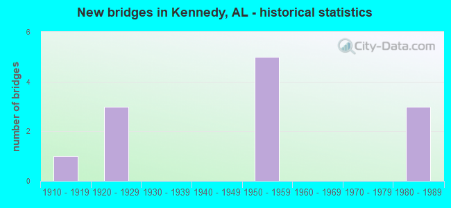
- New bridges - historical statistics
- 11910-1919
- 31920-1929
- 51950-1959
- 31980-1989


- Bridge Condition - Deck
- 40.0%Good
- 20.0%Satisfactory
- 20.0%Fair
- 20.0%Serious

- Bridge Condition - Superstructure
- 20.0%Good
- 40.0%Satisfactory
- 20.0%Fair
- 20.0%Serious

- Bridge Condition - Substructure
- 80.0%Satisfactory
- 20.0%Poor

- Bridge Condition - Channel
- 9.1%Good
- 63.6%Satisfactory
- 18.2%Fair
- 9.1%Poor

- Bridge Condition - Culverts
- 14.3%Good
- 57.1%Satisfactory
- 28.6%Fair
Find on map >> Show street view
Structure Number: 58, Location: Old 3rd ave se (Lat: 34.136014, Lng: -86.818744), Route carried "on" structure: County highway 35, Year Built: 1912, Status: Posted for load, Structure Length: 3.35m (10.99ft), Average Daily Traffic: 1,128 (year 1993), Truck Traffic: 1%, Average Future Daily Traffic: 1,300 (year 2034), Features Intersected: L*N RAIL ROAD, Facility Carried by Structure: OLD 3RD AVE SE
Minimum Vertical Clearance: 30+ m (98+ ft), Kilometerpoint: 0.000, Lanes on structure: 1, Owner: Railroad, Approaching Roadway Width: 7.3m (24.0ft), Skew: 9 degrees, Material/Design: Concrete continuous, Design/Construction: Girder and Floorbeam System, Number Of Spans In Main Unit: 3, Length of Maximum Span: 11.9m (39.0ft), Curb-To-Curb Width: 4.9m (16.1ft), Out-to-Out Width: 5.8m (19.0ft)
Condition: Deck: Serious, Superstructure: Serious, Substructure: Poor, Operating Rating: 2.7 metric tons, Method Used To Determine Operating Rating: Field evaluation and documented engineering judgment, Inventory Rating: 1.8 metric tons, Method Used To Determine Inventory Rating: Field evaluation and documented engineering judgment, Structural Evaluation: High priority of replacement, Deck Geometry: High priority of replacement, Underclear: Equal to present desirable criteria, Approach Roadway Alignment: Equal to present minimum criteria, Bridge Posting: Required (Relationship of Operating Rating to Maximum Legal Load: > 39.9% below), Length Of Structure Improvement: 4.23m (13.88ft), Designated Inspection Frequency: Every 24 months, Other Special Inspection Frequency: Every 3 months, Inspection Date: January 2021, Other Special Inspection Date: January 2022, Bridge Improvement Cost: $552,000, Roadway Improvement Cost: $55,000, Total Project Cost: $607,000 ( Estimate for 2022), Deck Structure Type: Concrete Cast-file-Place, Wearing Surface/Protective System: Wearing Surface: Bituminous
Find on map >> Show street view
Structure Number: 58, Location: KENNEDY (Lat: 33.587839, Lng: -87.984200), Route carried "on" structure: City street , Year Built: 1929, Status: Posted for load, Structure Length: 0.94m (3.08ft), Average Daily Traffic: 128 (year 2007), Truck Traffic: 1%, Average Future Daily Traffic: 192 (year 2032), Design Load: H 10, Features Intersected: Kennedy Branch, Facility Carried by Structure: PARK STREET
Minimum Vertical Clearance: 30+ m (98+ ft), Kilometerpoint: 0.100, Lanes on structure: 2, Owner: City or Municipal Highway Agency, Approaching Roadway Width: 4.9m (16.1ft), Material/Design: Wood or Timber, Design/Construction: Stringer/Multi-beam, Number Of Spans In Main Unit: 2, Length of Maximum Span: 4.6m (15.1ft), Curb-To-Curb Width: 5.4m (17.7ft), Out-to-Out Width: 6.3m (20.7ft)
Condition: Deck: Fair, Superstructure: Fair, Substructure: Satisfactory, Channel: Good, Operating Rating: 31.6 metric tons, Method Used To Determine Operating Rating: Allowable Stress (AS), Inventory Rating: 22.4 metric tons, Method Used To Determine Inventory Rating: Allowable Stress (AS), Structural Evaluation: Somewhat better than minimum adequacy, Deck Geometry: High priority of replacement, Waterway Adequacy: Better than present minimum criteria, Approach Roadway Alignment: Better than present minimum criteria, Bridge Posting: Required (Relationship of Operating Rating to Maximum Legal Load: 20.0 - 29.9% below), Length Of Structure Improvement: 1.61m (5.28ft), Designated Inspection Frequency: Every 24 months, Other Special Inspection Frequency: Every 12 months, Inspection Date: June 2020, Other Special Inspection Date: June 2021, Bridge Improvement Cost: $221,000, Roadway Improvement Cost: $22,000, Total Project Cost: $243,000 ( Estimate for 2022), Deck Structure Type: Concrete Cast-file-Place, Wearing Surface/Protective System: Wearing Surface: Bituminous
Find on map >> Show street view
Structure Number: 62, Location: 3.1 MI S OF MILLPORT (Lat: 33.569317, Lng: -88.024750), Route carried "on" structure: State highway 17, Year Built: 1929, Status: Open, Structure Length: 0.64m (2.10ft), Average Daily Traffic: 2,330 (year 2020), Truck Traffic: 27%, Average Future Daily Traffic: 3,005 (year 2038), Features Intersected: Clear Creek
Minimum Vertical Clearance: 30+ m (98+ ft), Kilometerpoint: 363.013, Lanes on structure: 2, Base Highway Network: Yes, Owner: State Highway Agency, Approaching Roadway Width: 11.0m (36.1ft), Material/Design: Concrete, Design/Construction: Culvert, Number Of Spans In Main Unit: 2, Length of Maximum Span: 3.0m (9.8ft), Curb-To-Curb Width: 7.9m (25.9ft), Out-to-Out Width: 8.2m (26.9ft)
Condition: Channel: Fair, Culverts: Satisfactory, Operating Rating: 88.9 metric tons, Method Used To Determine Operating Rating: Load Factor (LF), Inventory Rating: 57.0 metric tons, Method Used To Determine Inventory Rating: Load Factor (LF), Structural Evaluation: Equal to present minimum criteria, Deck Geometry: High priority of corrective action, Waterway Adequacy: Equal to present minimum criteria, Approach Roadway Alignment: Equal to present minimum criteria, Length Of Structure Improvement: 1.26m (4.13ft), Designated Inspection Frequency: Every 24 months, Inspection Date: March 2022, Bridge Improvement Cost: $313,000, Roadway Improvement Cost: $31,000, Total Project Cost: $344,000 ( Estimate for 2022), Deck Structure Type: Concrete Cast-file-Place, Wearing Surface/Protective System: Wearing Surface: Bituminous
Find on map >> Show street view
Structure Number: 686, Location: Kennedy (Lat: 33.587433, Lng: -87.983433), Route carried "on" structure: State highway 96, Year Built: 1929, Year Reconstructed: 1992, Status: Open, Structure Length: 0.94m (3.08ft), Average Daily Traffic: 1,710 (year 2020), Truck Traffic: 20%, Average Future Daily Traffic: 2,087 (year 2040), Design Load: H 15, Features Intersected: Kennedy Branch
Minimum Vertical Clearance: 30+ m (98+ ft), Kilometerpoint: 28.336, Lanes on structure: 2, Base Highway Network: Yes, Owner: State Highway Agency, Approaching Roadway Width: 9.1m (29.9ft), Material/Design: Concrete, Design/Construction: Culvert, Number Of Spans In Main Unit: 3, Length of Maximum Span: 3.0m (9.8ft)
Condition: Channel: Satisfactory, Culverts: Satisfactory, Operating Rating: 88.9 metric tons, Method Used To Determine Operating Rating: Load Factor (LF), Inventory Rating: 86.3 metric tons, Method Used To Determine Inventory Rating: Load Factor (LF), Structural Evaluation: Equal to present minimum criteria, Waterway Adequacy: Equal to present minimum criteria, Approach Roadway Alignment: Meets minimum limits, Length Of Structure Improvement: 1.62m (5.31ft), Designated Inspection Frequency: Every 24 months, Inspection Date: October 2020, Bridge Improvement Cost: $439,000, Roadway Improvement Cost: $44,000, Total Project Cost: $483,000 ( Estimate for 2022)
Find on map >> Show street view
Structure Number: 3978, Location: 0.3 MI. N.W. KENNEDY (Lat: 33.592761, Lng: -87.989964), Route carried "on" structure: County highway 49, Year Built: 1951, Status: Posted for load, Structure Length: 4.97m (16.31ft), Average Daily Traffic: 700 (year 2016), Truck Traffic: 7%, Average Future Daily Traffic: 1,040 (year 2036), Design Load: H 15, Features Intersected: LUXAPALLILA CREEK
Minimum Vertical Clearance: 30+ m (98+ ft), Kilometerpoint: 0.010, Lanes on structure: 2, Owner: County Highway Agency, Approaching Roadway Width: 8.5m (27.9ft), Skew: 3 degrees, Material/Design: Steel continuous, Design/Construction: Stringer/Multi-beam, Number Of Spans In Main Unit: 3, Length of Maximum Span: 18.3m (60.0ft), Curb-To-Curb Width: 6.7m (22.0ft), Out-to-Out Width: 7.3m (24.0ft)
Condition: Deck: Satisfactory, Superstructure: Satisfactory, Substructure: Satisfactory, Channel: Satisfactory, Operating Rating: 25.3 metric tons, Method Used To Determine Operating Rating: Allowable Stress (AS), Inventory Rating: 15.8 metric tons, Method Used To Determine Inventory Rating: Allowable Stress (AS), Structural Evaluation: Meets minimum limits, Deck Geometry: Meets minimum limits, Waterway Adequacy: Equal to present minimum criteria, Approach Roadway Alignment: Equal to present desirable criteria, Bridge Posting: Required (Relationship of Operating Rating to Maximum Legal Load: 30.0 - 39.9% below), Length Of Structure Improvement: 5.99m (19.65ft), Designated Inspection Frequency: Every 24 months, Other Special Inspection Frequency: Every 12 months, Inspection Date: December 2020, Other Special Inspection Date: December 2021, Bridge Improvement Cost: $985,000, Roadway Improvement Cost: $99,000, Total Project Cost: $1,084,000 ( Estimate for 2022), Deck Structure Type: Concrete Cast-file-Place
Find on map >> Show street view
Structure Number: 4746, Location: 0.8 MI. N.E. CO. RD. #49 (Lat: 33.606025, Lng: -87.982914), Route carried "on" structure: County highway 41, Year Built: 1954, Status: Open, Structure Length: 1.37m (4.49ft), Average Daily Traffic: 130 (year 2016), Truck Traffic: 13%, Average Future Daily Traffic: 193 (year 2036), Design Load: H 15, Features Intersected: MILL CREEK, Facility Carried by Structure: CODY RD
Minimum Vertical Clearance: 30+ m (98+ ft), Kilometerpoint: 0.010, Lanes on structure: 2, Owner: County Highway Agency, Approaching Roadway Width: 7.3m (24.0ft), Skew: 4 degrees, Material/Design: Concrete, Design/Construction: Culvert, Number Of Spans In Main Unit: 3, Length of Maximum Span: 4.6m (15.1ft)
Condition: Channel: Satisfactory, Culverts: Satisfactory, Operating Rating: 35.9 metric tons, Method Used To Determine Operating Rating: Load Factor (LF), Inventory Rating: 21.6 metric tons, Method Used To Determine Inventory Rating: Load Factor (LF), Structural Evaluation: Equal to present minimum criteria, Waterway Adequacy: Equal to present minimum criteria, Approach Roadway Alignment: Equal to present desirable criteria, Length Of Structure Improvement: 2.04m (6.69ft), Designated Inspection Frequency: Every 24 months, Inspection Date: December 2020, Bridge Improvement Cost: $342,000, Roadway Improvement Cost: $34,000, Total Project Cost: $376,000 ( Estimate for 2022), Wearing Surface/Protective System: Wearing Surface: Bituminous
Find on map >> Show street view
Structure Number: 4747, Location: 2.3 MI. N.E. CO. RD. 49 (Lat: 33.621731, Lng: -87.968433), Route carried "on" structure: County highway 41, Year Built: 1954, Status: Open, Structure Length: 1.37m (4.49ft), Average Daily Traffic: 130 (year 2016), Truck Traffic: 13%, Average Future Daily Traffic: 193 (year 2036), Design Load: H 15, Features Intersected: LUXAPALLILA TRIBUTARY, Facility Carried by Structure: CODY RD
Minimum Vertical Clearance: 30+ m (98+ ft), Kilometerpoint: 0.010, Lanes on structure: 2, Owner: County Highway Agency, Approaching Roadway Width: 7.3m (24.0ft), Skew: 4 degrees, Material/Design: Concrete, Design/Construction: Culvert, Number Of Spans In Main Unit: 3, Length of Maximum Span: 4.6m (15.1ft)
Condition: Channel: Poor, Culverts: Fair, Operating Rating: 52.2 metric tons, Method Used To Determine Operating Rating: Load Factor (LF), Inventory Rating: 31.3 metric tons, Method Used To Determine Inventory Rating: Load Factor (LF), Structural Evaluation: Somewhat better than minimum adequacy, Waterway Adequacy: Equal to present minimum criteria, Approach Roadway Alignment: Equal to present desirable criteria, Length Of Structure Improvement: 2.04m (6.69ft), Designated Inspection Frequency: Every 24 months, Inspection Date: December 2020, Bridge Improvement Cost: $342,000, Roadway Improvement Cost: $34,000, Total Project Cost: $376,000 ( Estimate for 2022), Wearing Surface/Protective System: Wearing Surface: Bituminous
Find on map >> Show street view
Structure Number: 5045, Location: 3.5 MI. E. HWY. 17 (Lat: 33.616064, Lng: -88.025844), Route carried "on" structure: County highway 12, Year Built: 1955, Status: Open, Structure Length: 1.52m (4.99ft), Average Daily Traffic: 150 (year 1995), Truck Traffic: 1%, Average Future Daily Traffic: 150 (year 2032), Design Load: H 15, Features Intersected: COOPER CREEK, Facility Carried by Structure: MT PLEASANT CH RD
Minimum Vertical Clearance: 30+ m (98+ ft), Kilometerpoint: 0.010, Lanes on structure: 2, Owner: County Highway Agency, Approaching Roadway Width: 7.3m (24.0ft), Material/Design: Concrete, Design/Construction: Culvert, Number Of Spans In Main Unit: 4, Length of Maximum Span: 3.7m (12.1ft)
Condition: Channel: Satisfactory, Culverts: Fair, Operating Rating: 47.3 metric tons, Method Used To Determine Operating Rating: Load Factor (LF), Inventory Rating: 28.3 metric tons, Method Used To Determine Inventory Rating: Load Factor (LF), Structural Evaluation: Somewhat better than minimum adequacy, Waterway Adequacy: Equal to present minimum criteria, Approach Roadway Alignment: Equal to present desirable criteria, Length Of Structure Improvement: 2.20m (7.22ft), Designated Inspection Frequency: Every 24 months, Inspection Date: December 2020, Bridge Improvement Cost: $394,000, Roadway Improvement Cost: $39,000, Total Project Cost: $433,000 ( Estimate for 2022), Wearing Surface/Protective System: Wearing Surface: Bituminous
Find on map >> Show street view
Structure Number: 5418, Location: 2.6 MI. S.E. HWY. #96 (Lat: 33.555206, Lng: -87.947331), Route carried "on" structure: County highway 2, Year Built: 1956, Status: Open, Structure Length: 1.28m (4.20ft), Average Daily Traffic: 260 (year 2016), Truck Traffic: 10%, Average Future Daily Traffic: 386 (year 2036), Design Load: H 15, Features Intersected: COAL FIRE CREEK
Minimum Vertical Clearance: 30+ m (98+ ft), Kilometerpoint: 0.010, Lanes on structure: 2, Owner: County Highway Agency, Approaching Roadway Width: 7.3m (24.0ft), Material/Design: Concrete, Design/Construction: Culvert, Number Of Spans In Main Unit: 4, Length of Maximum Span: 3.0m (9.8ft)
Condition: Channel: Satisfactory, Culverts: Satisfactory, Operating Rating: 60.7 metric tons, Method Used To Determine Operating Rating: Load Factor (LF), Inventory Rating: 36.4 metric tons, Method Used To Determine Inventory Rating: Load Factor (LF), Structural Evaluation: Equal to present minimum criteria, Waterway Adequacy: Equal to present minimum criteria, Approach Roadway Alignment: Better than present minimum criteria, Length Of Structure Improvement: 1.95m (6.40ft), Designated Inspection Frequency: Every 24 months, Inspection Date: December 2020, Bridge Improvement Cost: $440,000, Roadway Improvement Cost: $44,000, Total Project Cost: $484,000 ( Estimate for 2022), Wearing Surface/Protective System: Wearing Surface: Bituminous
Find on map >> Show street view
Structure Number: 12939, Location: 3.7 MI. S. KENNEDY (Lat: 33.530611, Lng: -87.977094), Route carried "on" structure: County highway , Year Built: 1983, Status: Posted for load, Structure Length: 2.07m (6.79ft), Average Daily Traffic: 30 (year 1995), Average Future Daily Traffic: 30 (year 2032), Design Load: H 15, Features Intersected: COAL FIRE CREEK, Facility Carried by Structure: LINDSEY RD
Minimum Vertical Clearance: 30+ m (98+ ft), Kilometerpoint: 0.010, Lanes on structure: 2, Owner: County Highway Agency, Approaching Roadway Width: 7.3m (24.0ft), Material/Design: Concrete, Design/Construction: Channel Beam, Number Of Spans In Main Unit: 2, Length of Maximum Span: 10.4m (34.1ft), Curb-To-Curb Width: 7.5m (24.6ft), Out-to-Out Width: 8.3m (27.2ft)
Condition: Deck: Good, Superstructure: Good, Substructure: Satisfactory, Channel: Satisfactory, Operating Rating: 38.1 metric tons, Method Used To Determine Operating Rating: Allowable Stress (AS), Inventory Rating: 19.1 metric tons, Method Used To Determine Inventory Rating: Allowable Stress (AS), Structural Evaluation: Somewhat better than minimum adequacy, Deck Geometry: Equal to present minimum criteria, Waterway Adequacy: Better than present minimum criteria, Approach Roadway Alignment: Equal to present minimum criteria, Bridge Posting: Required (Relationship of Operating Rating to Maximum Legal Load: 10.0 - 19.9% below), Length Of Structure Improvement: 2.84m (9.32ft), Designated Inspection Frequency: Every 24 months, Other Special Inspection Frequency: Every 12 months, Inspection Date: December 2020, Other Special Inspection Date: December 2021, Bridge Improvement Cost: $526,000, Roadway Improvement Cost: $53,000, Total Project Cost: $579,000 ( Estimate for 2022), Deck Structure Type: Concrete Precast Panels
Find on map >> Show street view
Structure Number: 12992, Location: 0.7 MI S LAMAR CO LINE (Lat: 33.516031, Lng: -87.982433), Route carried "on" structure: State highway 17, Year Built: 1983, Status: Open, Structure Length: 6.22m (20.41ft), Average Daily Traffic: 880 (year 2020), Truck Traffic: 29%, Average Future Daily Traffic: 1,135 (year 2040), Design Load: HS 20, Features Intersected: Coal Fire Creek
Minimum Vertical Clearance: 30+ m (98+ ft), Kilometerpoint: 354.155, Lanes on structure: 2, Base Highway Network: Yes, Owner: State Highway Agency, Approaching Roadway Width: 12.2m (40.0ft), Material/Design: Prestressed concrete continuous, Design/Construction: Stringer/Multi-beam, Number Of Spans In Main Unit: 6, Length of Maximum Span: 10.4m (34.1ft), Curb-To-Curb Width: 12.2m (40.0ft), Out-to-Out Width: 13.1m (43.0ft)
Condition: Deck: Good, Superstructure: Satisfactory, Substructure: Satisfactory, Channel: Fair, Operating Rating: 57.2 metric tons, Method Used To Determine Operating Rating: Load Factor (LF), Inventory Rating: 34.0 metric tons, Method Used To Determine Inventory Rating: Load Factor (LF), Structural Evaluation: Equal to present minimum criteria, Deck Geometry: Equal to present desirable criteria, Waterway Adequacy: Equal to present minimum criteria, Approach Roadway Alignment: Equal to present minimum criteria, Length Of Structure Improvement: 7.26m (23.82ft), Designated Inspection Frequency: Every 24 months, Inspection Date: March 2020, Bridge Improvement Cost: $2,090,000, Roadway Improvement Cost: $209,000, Total Project Cost: $2,299,000 ( Estimate for 2022), Deck Structure Type: Concrete Cast-file-Place
Find on map >> Show street view
Structure Number: 14481, Location: .75 MI. N.W. KENNEDY (Lat: 33.596778, Lng: -87.991972), Route carried "on" structure: County highway 49, Year Built: 1988, Status: Open, Structure Length: 1.10m (3.61ft), Average Daily Traffic: 700 (year 2016), Truck Traffic: 7%, Average Future Daily Traffic: 1,040 (year 2036), Design Load: HS 20, Features Intersected: LUXAPALLILA CREEK RELIEF
Minimum Vertical Clearance: 30+ m (98+ ft), Kilometerpoint: 0.010, Lanes on structure: 2, Owner: County Highway Agency, Approaching Roadway Width: 7.9m (25.9ft), Material/Design: Concrete, Design/Construction: Culvert, Number Of Spans In Main Unit: 3, Length of Maximum Span: 3.7m (12.1ft), Curb-To-Curb Width: 8.6m (28.2ft), Out-to-Out Width: 9.1m (29.9ft)
Condition: Channel: Satisfactory, Culverts: Good, Operating Rating: 88.4 metric tons, Method Used To Determine Operating Rating: Load Factor (LF), Inventory Rating: 53.0 metric tons, Method Used To Determine Inventory Rating: Load Factor (LF), Structural Evaluation: Better than present minimum criteria, Deck Geometry: Somewhat better than minimum adequacy, Waterway Adequacy: Better than present minimum criteria, Approach Roadway Alignment: Equal to present desirable criteria, Length Of Structure Improvement: 1.77m (5.81ft), Designated Inspection Frequency: Every 24 months, Inspection Date: December 2020, Bridge Improvement Cost: $307,000, Roadway Improvement Cost: $31,000, Total Project Cost: $338,000 ( Estimate for 2022), Deck Structure Type: Concrete Cast-file-Place, Wearing Surface/Protective System: Wearing Surface: Bituminous