Bridge Statistics for Krotz Springs, Louisiana (LA)
Condition, Traffic, Stress, Structural Evaluation, Project Costs
- National Bridge Inventory (NBI) Statistics
- 19Number of bridges
- 1,594ft / 486mTotal length
- 55,350Total average daily traffic
- 10,392Total average daily truck traffic
- National Bridge Inventory (NBI) Registered Bridges for Krotz Springs
- No street view available for this location
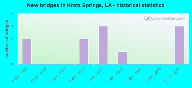
- New bridges - historical statistics
- 21930-1939
- 21960-1969
- 31970-1979
- 11980-1989
- 32010-2019


- Bridge Condition - Deck
- 9.1%Excellent
- 36.4%Good
- 54.5%Satisfactory

- Bridge Condition - Superstructure
- 9.1%Excellent
- 36.4%Good
- 27.3%Satisfactory
- 27.3%Fair

- Bridge Condition - Substructure
- 9.1%Excellent
- 45.5%Good
- 18.2%Satisfactory
- 27.3%Fair

- Bridge Condition - Channel
- 25.0%Very good
- 62.5%Good
- 12.5%Satisfactory
Find on map >> Show street view
Structure Number: 34900000000093, Location: .10 Mi S. of US 190 (Lat: 30.513439, Lng: -92.228481), Route carried "on" structure: County highway , Year Built: 2019, Status: Open, Structure Length: 3.66m (12.01ft), Average Daily Traffic: 50 (year 2020), Average Future Daily Traffic: 55 (year 2040), Design Load: HL 93, Features Intersected: Mallet Bayou, Facility Carried by Structure: Rozena Road
Minimum Vertical Clearance: 30+ m (98+ ft), Kilometerpoint: 0.000, Lanes on structure: 2, Owner: County Highway Agency, Approaching Roadway Width: 4.9m (16.1ft), Material/Design: Prestressed concrete, Design/Construction: Stringer/Multi-beam, Number Of Spans In Main Unit: 3, Length of Maximum Span: 12.2m (40.0ft), Curb-To-Curb Width: 7.1m (23.3ft), Out-to-Out Width: 8.1m (26.6ft)
Condition: Deck: Excellent, Superstructure: Excellent, Substructure: Excellent, Channel: Good, Operating Rating: 64.8 metric tons, Method Used To Determine Operating Rating: Load and Resistance Factor Rating (LRFR) rating reported by rating factor(RF) method using HL-93 loadings, Inventory Rating: 38.9 metric tons, Method Used To Determine Inventory Rating: Load and Resistance Factor Rating (LRFR) rating reported by rating factor(RF) method using HL-93 loadings, Structural Evaluation: Superior to present desirable criteria, Deck Geometry: Somewhat better than minimum adequacy, Waterway Adequacy: Equal to present minimum criteria, Approach Roadway Alignment: Equal to present desirable criteria, Designated Inspection Frequency: Every 24 months, Inspection Date: January 2021, Deck Structure Type: Concrete Cast-file-Place
Find on map >> Show street view
Structure Number: 34900000030385, Location: 2.5 MI W of LA 3174 (Lat: 30.545661, Lng: -91.813500), Route carried "on" structure: US 190, Year Built: 2010, Status: Open, Structure Length: 7.62m (25.00ft), Average Daily Traffic: 6,050 (year 2016), Truck Traffic: 24%, Average Future Daily Traffic: 15,470 (year 2036), Design Load: HS 20, Features Intersected: US0071
Minimum Vertical Clearance: 30+ m (98+ ft), Kilometerpoint: 26.104, Lanes on structure: 2, Lanes under structure: 2, Base Highway Network: Yes (Inventory Route: 12-13-1, Subroute: 10), Owner: State Highway Agency, Approaching Roadway Width: 7.3m (24.0ft), Skew: 34 degrees, Material/Design: Steel, Design/Construction: Stringer/Multi-beam, Number Of Spans In Main Unit: 5, Length of Maximum Span: 21.3m (69.9ft), Curb-To-Curb Width: 11.6m (38.1ft), Out-to-Out Width: 12.4m (40.7ft)
Condition: Deck: Good, Superstructure: Good, Substructure: Good, Operating Rating: 48.6 metric tons, Method Used To Determine Operating Rating: Load and Resistance Factor Rating (LRFR) rating reported by rating factor(RF) method using HL-93 loadings, Inventory Rating: 37.6 metric tons, Method Used To Determine Inventory Rating: Load and Resistance Factor Rating (LRFR) rating reported by rating factor(RF) method using HL-93 loadings, Structural Evaluation: Better than present minimum criteria, Deck Geometry: Better than present minimum criteria, Underclear: Better than present minimum criteria, Approach Roadway Alignment: Equal to present desirable criteria, Designated Inspection Frequency: Every 24 months, Inspection Date: August 2020, Deck Structure Type: Concrete Cast-file-Place, Wearing Surface/Protective System: Wearing Surface: Monolithic Concrete
Find on map >> Show street view
Structure Number: 34900000030386, Location: US 190 OVER US 71 (Lat: 30.545689, Lng: -91.812800), Route carried "on" structure: US 190, Year Built: 2010, Status: Open, Structure Length: 7.65m (25.10ft), Average Daily Traffic: 6,050 (year 2016), Truck Traffic: 24%, Average Future Daily Traffic: 9,282 (year 2036), Design Load: HS 20, Features Intersected: US 71 OVERPASS
Minimum Vertical Clearance: 30+ m (98+ ft), Kilometerpoint: 0.005, Lanes on structure: 2, Lanes under structure: 2, Base Highway Network: Yes (Inventory Route: 12-13-2, Subroute: 10), Owner: State Highway Agency, Approaching Roadway Width: 7.3m (24.0ft), Skew: 34 degrees, Material/Design: Steel, Design/Construction: Stringer/Multi-beam, Number Of Spans In Main Unit: 1, Number Of Approach Spans: 4, Length of Maximum Span: 21.3m (69.9ft), Curb-To-Curb Width: 11.5m (37.7ft), Out-to-Out Width: 12.4m (40.7ft)
Condition: Deck: Good, Superstructure: Good, Substructure: Good, Operating Rating: 65.8 metric tons, Method Used To Determine Operating Rating: Load and Resistance Factor Rating (LRFR) rating reported by rating factor(RF) method using HL-93 loadings, Inventory Rating: 50.9 metric tons, Method Used To Determine Inventory Rating: Load and Resistance Factor Rating (LRFR) rating reported by rating factor(RF) method using HL-93 loadings, Structural Evaluation: Better than present minimum criteria, Deck Geometry: Equal to present minimum criteria, Underclear: Better than present minimum criteria, Approach Roadway Alignment: Equal to present desirable criteria, Designated Inspection Frequency: Every 24 months, Inspection Date: August 2020, Deck Structure Type: Concrete Cast-file-Place, Wearing Surface/Protective System: Wearing Surface: Monolithic Concrete
Find on map >> Show street view
Structure Number: 34900080400001, Location: 0.25 Mi W of LA 975 (Lat: 30.548439, Lng: -91.744619), Route carried "on" structure: US 190, Year Built: 1973, Status: Open, Structure Length: 103.72m (340.29ft), Average Daily Traffic: 6,000 (year 2016), Truck Traffic: 24%, Average Future Daily Traffic: 9,204 (year 2036), Design Load: HS 20, Features Intersected: ATCHAFALAYA R @ K'SPNGS
Minimum Vertical Clearance: 5.79m (19.00ft), Kilometerpoint: 0.005, Lanes on structure: 2, Lanes under structure: 2, Base Highway Network: Yes (Inventory Route: 8-04-1, Subroute: 10), Owner: State Highway Agency, Approaching Roadway Width: 11.6m (38.1ft), Skew: 10 degrees, Navigation Control: Yes ( Vertical Clearance: 25.9m (85.0ft), Horizontal Clearance: 241.4m (792.0ft)), Material/Design: Steel, Design/Construction: Truss - Thru, Number Of Spans In Main Unit: 3, Number Of Approach Spans: 23, Length of Maximum Span: 237.7m (779.9ft), Curb-To-Curb Width: 10.4m (34.1ft), Out-to-Out Width: 11.7m (38.4ft)
Condition: Deck: Satisfactory, Superstructure: Fair, Substructure: Satisfactory, Channel: Good, Operating Rating: 42.8 metric tons, Method Used To Determine Operating Rating: Load and Resistance Factor Rating (LRFR) rating reported by rating factor(RF) method using HL-93 loadings, Inventory Rating: 33.0 metric tons, Method Used To Determine Inventory Rating: Load and Resistance Factor Rating (LRFR) rating reported by rating factor(RF) method using HL-93 loadings, Structural Evaluation: Somewhat better than minimum adequacy, Deck Geometry: Somewhat better than minimum adequacy, Underclear: Superior to present desirable criteria, Waterway Adequacy: Better than present minimum criteria, Approach Roadway Alignment: Equal to present desirable criteria, Designated Inspection Frequency: Every 24 months, Critical Feature Inspection Frequency: Every 24 months, Underwater Inspection Frequency: Every 60 months, Inspection Date: March 2020, Critical Feature Inspection Date: March 2020, Underwater Inspection Date: April 2017, Deck Structure Type: Concrete Cast-file-Place
Find on map >> Show street view
Structure Number: 34900080400002, Location: 4.0 MI E of US 71 (Lat: 30.544011, Lng: -91.754311), Route carried "on" structure: US 190, Year Built: 1988, Status: Open, Structure Length: 104.70m (343.50ft), Average Daily Traffic: 4,750 (year 2016), Truck Traffic: 24%, Average Future Daily Traffic: 9,048 (year 2036), Design Load: HS 20, Features Intersected: ATCHAFALAYA R @ K'SPNGS
Minimum Vertical Clearance: 7.62m (25.00ft), Kilometerpoint: 5.786, Lanes on structure: 2, Lanes under structure: 2, Base Highway Network: Yes (Inventory Route: 8-04-2, Subroute: 10), Owner: State Highway Agency, Approaching Roadway Width: 12.2m (40.0ft), Skew: 10 degrees, Navigation Control: Yes ( Vertical Clearance: 30.5m (100.1ft), Horizontal Clearance: 149.7m (491.1ft)), Material/Design: Steel, Design/Construction: Truss - Thru, Number Of Spans In Main Unit: 23, Length of Maximum Span: 154.2m (505.9ft), Curb-To-Curb Width: 12.2m (40.0ft), Out-to-Out Width: 13.0m (42.7ft)
Condition: Deck: Satisfactory, Superstructure: Fair, Substructure: Fair, Channel: Good, Operating Rating: 33.7 metric tons, Method Used To Determine Operating Rating: Load and Resistance Factor Rating (LRFR) rating reported by rating factor(RF) method using HL-93 loadings, Inventory Rating: 25.9 metric tons, Method Used To Determine Inventory Rating: Load and Resistance Factor Rating (LRFR) rating reported by rating factor(RF) method using HL-93 loadings, Structural Evaluation: Somewhat better than minimum adequacy, Deck Geometry: Better than present minimum criteria, Underclear: Superior to present desirable criteria, Approach Roadway Alignment: Equal to present desirable criteria, Designated Inspection Frequency: Every 24 months, Critical Feature Inspection Frequency: Every 24 months, Underwater Inspection Frequency: Every 60 months, Inspection Date: March 2020, Critical Feature Inspection Date: March 2020, Underwater Inspection Date: April 2017, Deck Structure Type: Concrete Cast-file-Place
Find on map >> Show street view
Structure Number: 34900080401231, Location: 0.72 Mi W of LA 105 (Lat: 30.539761, Lng: -91.764200), Route carried "on" structure: US 190, Year Built: 1972, Status: Open, Structure Length: 3.29m (10.79ft), Average Daily Traffic: 6,000 (year 2016), Truck Traffic: 24%, Average Future Daily Traffic: 9,204 (year 2036), Design Load: HS 20, Features Intersected: LATANIS BAYOU
Minimum Vertical Clearance: 30+ m (98+ ft), Kilometerpoint: 5.604, Lanes on structure: 2, Base Highway Network: Yes (Inventory Route: 8-04-2, Subroute: 10), Owner: State Highway Agency, Approaching Roadway Width: 11.0m (36.1ft), Skew: 30 degrees, Material/Design: Prestressed concrete, Design/Construction: Stringer/Multi-beam, Number Of Spans In Main Unit: 2, Length of Maximum Span: 16.5m (54.1ft), Curb-To-Curb Width: 10.6m (34.8ft), Out-to-Out Width: 11.5m (37.7ft)
Condition: Deck: Good, Superstructure: Good, Substructure: Good, Channel: Good, Operating Rating: 88.0 metric tons, Method Used To Determine Operating Rating: Load Factor (LF), Inventory Rating: 44.4 metric tons, Method Used To Determine Inventory Rating: Load Factor (LF), Structural Evaluation: Better than present minimum criteria, Deck Geometry: Somewhat better than minimum adequacy, Waterway Adequacy: Equal to present desirable criteria, Approach Roadway Alignment: Equal to present desirable criteria, Designated Inspection Frequency: Every 24 months, Inspection Date: May 2020, Deck Structure Type: Concrete Cast-file-Place
Find on map >> Show street view
Structure Number: 34900080401232, Location: 3.00 Mi E of US 71 (Lat: 30.539969, Lng: -91.764100), Route carried "on" structure: US 190, Year Built: 1972, Status: Open, Structure Length: 3.29m (10.79ft), Average Daily Traffic: 1,250 (year 2016), Truck Traffic: 24%, Average Future Daily Traffic: 1,872 (year 2036), Design Load: HS 20, Features Intersected: LATANIS BAYOU
Minimum Vertical Clearance: 30+ m (98+ ft), Kilometerpoint: 2.095, Lanes on structure: 2, Base Highway Network: Yes (Inventory Route: 8-04-1, Subroute: 10), Owner: State Highway Agency, Approaching Roadway Width: 11.0m (36.1ft), Skew: 30 degrees, Material/Design: Prestressed concrete, Design/Construction: Stringer/Multi-beam, Number Of Spans In Main Unit: 2, Length of Maximum Span: 16.5m (54.1ft), Curb-To-Curb Width: 10.6m (34.8ft), Out-to-Out Width: 12.0m (39.4ft)
Condition: Deck: Good, Superstructure: Good, Substructure: Good, Channel: Very good, Operating Rating: 84.4 metric tons, Method Used To Determine Operating Rating: Load Factor (LF), Inventory Rating: 43.5 metric tons, Method Used To Determine Inventory Rating: Load Factor (LF), Structural Evaluation: Better than present minimum criteria, Deck Geometry: Somewhat better than minimum adequacy, Waterway Adequacy: Equal to present desirable criteria, Approach Roadway Alignment: Equal to present desirable criteria, Designated Inspection Frequency: Every 24 months, Inspection Date: May 2020, Deck Structure Type: Concrete Cast-file-Place
Find on map >> Show street view
Structure Number: 34900080402331, Location: 2.0 MI EAST OF LA 975 (Lat: 30.541111, Lng: -91.782000), Route carried "on" structure: US 190, Year Built: 1961, Year Reconstructed: 1977, Status: Open, Structure Length: 121.43m (398.39ft), Average Daily Traffic: 6,600 (year 2016), Truck Traffic: 24%, Average Future Daily Traffic: 10,140 (year 2036), Design Load: HS 20, Features Intersected: ATCHAFALAYA FLOODWAY
Minimum Vertical Clearance: 30+ m (98+ ft), Kilometerpoint: 3.848, Lanes on structure: 2, Base Highway Network: Yes (Inventory Route: 8-04-1, Subroute: 10), Owner: State Highway Agency, Approaching Roadway Width: 12.2m (40.0ft), Skew: 10 degrees, Material/Design: Prestressed concrete, Design/Construction: Stringer/Multi-beam, Number Of Spans In Main Unit: 77, Length of Maximum Span: 15.9m (52.2ft), Curb-To-Curb Width: 9.3m (30.5ft), Out-to-Out Width: 10.5m (34.4ft)
Condition: Deck: Satisfactory, Superstructure: Satisfactory, Substructure: Good, Operating Rating: 85.3 metric tons, Method Used To Determine Operating Rating: Load Factor (LF), Inventory Rating: 42.6 metric tons, Method Used To Determine Inventory Rating: Load Factor (LF), Structural Evaluation: Equal to present minimum criteria, Deck Geometry: Meets minimum limits, Waterway Adequacy: Equal to present desirable criteria, Approach Roadway Alignment: Equal to present desirable criteria, Designated Inspection Frequency: Every 24 months, Inspection Date: Febuary 2022, Deck Structure Type: Concrete Cast-file-Place
Find on map >> Show street view
Structure Number: 34900080402332, Location: 1.88 Mi E of US 71 (Lat: 30.542839, Lng: -91.794500), Route carried "on" structure: US 190, Year Built: 1961, Year Reconstructed: 1984, Status: Open, Structure Length: 121.43m (398.39ft), Average Daily Traffic: 6,600 (year 2016), Truck Traffic: 24%, Average Future Daily Traffic: 10,140 (year 2036), Design Load: HS 20, Features Intersected: ATCHAFALAYA FLDWY
Minimum Vertical Clearance: 30+ m (98+ ft), Kilometerpoint: 2.641, Lanes on structure: 2, Base Highway Network: Yes (Inventory Route: 8-04-2, Subroute: 10), Owner: State Highway Agency, Approaching Roadway Width: 12.2m (40.0ft), Skew: 12 degrees, Material/Design: Prestressed concrete, Design/Construction: Stringer/Multi-beam, Number Of Spans In Main Unit: 77, Length of Maximum Span: 15.2m (49.9ft), Curb-To-Curb Width: 9.2m (30.2ft), Out-to-Out Width: 12.3m (40.4ft)
Condition: Deck: Satisfactory, Superstructure: Fair, Substructure: Fair, Channel: Very good, Operating Rating: 85.3 metric tons, Method Used To Determine Operating Rating: Load Factor (LF), Inventory Rating: 42.6 metric tons, Method Used To Determine Inventory Rating: Load Factor (LF), Structural Evaluation: Somewhat better than minimum adequacy, Deck Geometry: Meets minimum limits, Waterway Adequacy: Equal to present desirable criteria, Approach Roadway Alignment: Equal to present desirable criteria, Designated Inspection Frequency: Every 24 months, Inspection Date: Febuary 2022, Deck Structure Type: Concrete Cast-file-Place
Find on map >> Show street view
Structure Number: 34930323914651, Location: 0.26 Mi SE of US 190 (Lat: 30.538650, Lng: -91.775039), Route carried "on" structure: County highway , Year Built: 1930, Status: Posted for load, Structure Length: 2.47m (8.10ft), Average Daily Traffic: 270 (year 2020), Average Future Daily Traffic: 297 (year 2040), Design Load: HS 15, Features Intersected: DRAINAGE BAYOU, Facility Carried by Structure: Old US 190
Minimum Vertical Clearance: 30+ m (98+ ft), Kilometerpoint: 0.000, Lanes on structure: 2, Owner: County Highway Agency, Approaching Roadway Width: 14.6m (47.9ft), Material/Design: Concrete, Design/Construction: Tee Beam, Number Of Spans In Main Unit: 3, Length of Maximum Span: 8.2m (26.9ft), Curb-To-Curb Width: 12.2m (40.0ft), Out-to-Out Width: 13.1m (43.0ft)
Condition: Deck: Satisfactory, Superstructure: Satisfactory, Substructure: Satisfactory, Channel: Satisfactory, Operating Rating: 23.7 metric tons, Method Used To Determine Operating Rating: Load and Resistance Factor Rating (LRFR) rating reported by rating factor(RF) method using HL-93 loadings, Inventory Rating: 18.1 metric tons, Method Used To Determine Inventory Rating: Load and Resistance Factor Rating (LRFR) rating reported by rating factor(RF) method using HL-93 loadings, Structural Evaluation: Somewhat better than minimum adequacy, Deck Geometry: Superior to present desirable criteria, Waterway Adequacy: Equal to present minimum criteria, Approach Roadway Alignment: Equal to present minimum criteria, Bridge Posting: Required (Relationship of Operating Rating to Maximum Legal Load: 20.0 - 29.9% below), Designated Inspection Frequency: Every 24 months, Inspection Date: April 2021, Deck Structure Type: Concrete Cast-file-Place
Find on map >> Show street view
Structure Number: 34930324914741, Location: 1.1 Mi. W. of LA 3174 (Lat: 30.540861, Lng: -91.789889), Route carried "on" structure: County highway , Year Built: 1930, Status: Posted for load, Structure Length: 6.61m (21.69ft), Average Daily Traffic: 270 (year 2020), Average Future Daily Traffic: 297 (year 2040), Design Load: HS 15, Features Intersected: HALF MOON BAYOU, Facility Carried by Structure: Old US 190
Minimum Vertical Clearance: 30+ m (98+ ft), Kilometerpoint: 0.000, Lanes on structure: 2, Owner: County Highway Agency, Approaching Roadway Width: 14.9m (48.9ft), Material/Design: Concrete, Design/Construction: Tee Beam, Number Of Spans In Main Unit: 8, Length of Maximum Span: 8.2m (26.9ft), Curb-To-Curb Width: 12.2m (40.0ft), Out-to-Out Width: 13.4m (44.0ft)
Condition: Deck: Satisfactory, Superstructure: Satisfactory, Substructure: Fair, Channel: Good, Operating Rating: 23.7 metric tons, Method Used To Determine Operating Rating: Load and Resistance Factor Rating (LRFR) rating reported by rating factor(RF) method using HL-93 loadings, Inventory Rating: 18.1 metric tons, Method Used To Determine Inventory Rating: Load and Resistance Factor Rating (LRFR) rating reported by rating factor(RF) method using HL-93 loadings, Structural Evaluation: Somewhat better than minimum adequacy, Deck Geometry: Superior to present desirable criteria, Waterway Adequacy: Equal to present desirable criteria, Approach Roadway Alignment: Equal to present minimum criteria, Bridge Posting: Required (Relationship of Operating Rating to Maximum Legal Load: 30.0 - 39.9% below), Designated Inspection Frequency: Every 24 months, Underwater Inspection Frequency: Every 60 months, Other Special Inspection Frequency: Every 12 months, Inspection Date: April 2021, Underwater Inspection Date: May 2018, Other Special Inspection Date: April 2020, Deck Structure Type: Concrete Cast-file-Place
Find on map >> Show street view
Structure Number: 34900000030385, Location: 3.6 MI W OF LA 105 (Lat: 30.545650, Lng: -91.813050), Route carried "under" structure: US 71, Structure Length: 0. m, Average Daily Traffic: 1,550 (year 2016), Features Intersected: US 71 NB UNDER US 190 EB
Minimum Vertical Clearance: 5.15m (16.90ft), Kilometerpoint: 0.050, Lanes on structure: 2, Lanes under structure: 2, Length of Maximum Span: 0.0m
Find on map >> Show street view
Structure Number: 34900000030385, Location: 3.6 MI W OF LA 105 (Lat: 30.545519, Lng: -91.813011), Route carried "under" structure: US 71, Structure Length: 0. m, Average Daily Traffic: 1,550 (year 2016), Features Intersected: US 71 SB UNDER US 190 EB
Minimum Vertical Clearance: 5.03m (16.50ft), Kilometerpoint: 21.185, Lanes on structure: 2, Lanes under structure: 2, Length of Maximum Span: 0.0m
Find on map >> Show street view
Structure Number: 34900000030386, Location: 3.6 MI W OF LA 105 (Lat: 30.545661, Lng: -91.813050), Route carried "under" structure: US 71, Structure Length: 0. m, Average Daily Traffic: 1,550 (year 2016), Features Intersected: US 71 NB UNDER US 190 WB
Minimum Vertical Clearance: 5.12m (16.80ft), Kilometerpoint: 0.504, Lanes on structure: 2, Lanes under structure: 2, Length of Maximum Span: 0.0m
Find on map >> Show street view
Structure Number: 34900000030386, Location: 3.6 MI W OF LA 105 (Lat: 30.545831, Lng: -91.813300), Route carried "under" structure: US 71, Structure Length: 0. m, Average Daily Traffic: 1,550 (year 2016), Features Intersected: US 71 SB UNDER US 190 WB
Minimum Vertical Clearance: 5.03m (16.50ft), Kilometerpoint: 25.970, Lanes on structure: 2, Lanes under structure: 2, Length of Maximum Span: 0.0m
Find on map >> Show street view
Structure Number: 34900080400001, Location: 1.0 MI E OF LA 105 (Lat: 30.548211, Lng: -91.745400), Route carried "under" structure: State highway 975, Structure Length: 0. m, Average Daily Traffic: 130 (year 2016), Features Intersected: LA 975 UNDER US 190 WB
Minimum Vertical Clearance: 4.72m (15.49ft), Kilometerpoint: 0.061, Lanes on structure: 2, Lanes under structure: 2, Length of Maximum Span: 0.0m
Find on map >> Show street view
Structure Number: 34900080400001, Location: 0.7 MI N OF LA 3173 (Lat: 30.544781, Lng: -91.753339), Route carried "under" structure: State highway 105, Structure Length: 0. m, Average Daily Traffic: 2,500 (year 2016), Features Intersected: LA 105 UNDER US 190 WB
Minimum Vertical Clearance: 7.68m (25.20ft), Kilometerpoint: 1.283, Lanes on structure: 2, Lanes under structure: 2, Length of Maximum Span: 0.0m
Find on map >> Show street view
Structure Number: 34900080400002, Location: 1.0 MI E OF LA 105 (Lat: 30.547869, Lng: -91.745219), Route carried "under" structure: State highway 975, Structure Length: 0. m, Average Daily Traffic: 130 (year 2016), Features Intersected: LA 975 UNDER US 190 EB
Minimum Vertical Clearance: 4.94m (16.21ft), Kilometerpoint: 0.103, Lanes on structure: 2, Lanes under structure: 2, Length of Maximum Span: 0.0m
Find on map >> Show street view
Structure Number: 34900080400002, Location: 0.7 MI N OF LA 3173 (Lat: 30.544389, Lng: -91.753219), Route carried "under" structure: State highway 105, Structure Length: 0. m, Average Daily Traffic: 2,500 (year 2016), Features Intersected: LA 105 UNDER US 190 EB
Minimum Vertical Clearance: 9.48m (31.10ft), Kilometerpoint: 1.239, Lanes on structure: 2, Lanes under structure: 2, Length of Maximum Span: 0.0m