Bridge Statistics for Lake Isabella, California (CA)
Condition, Traffic, Stress, Structural Evaluation, Project Costs
- National Bridge Inventory (NBI) Statistics
- 15Number of bridges
- 171ft / 51.5mTotal length
- 52,810Total average daily traffic
- 5,170Total average daily truck traffic
- National Bridge Inventory (NBI) Registered Bridges for Lake Isabella
- No street view available for this location
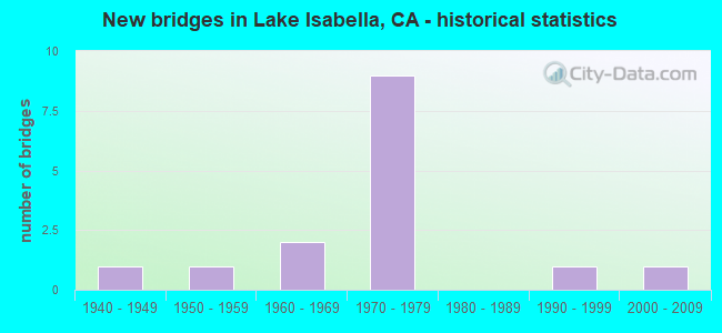
- New bridges - historical statistics
- 11940-1949
- 11950-1959
- 21960-1969
- 91970-1979
- 11990-1999
- 12000-2009
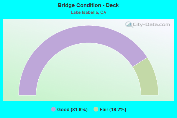
- Bridge Condition - Deck
- 81.8%Good
- 18.2%Fair

- Bridge Condition - Channel
- 22.2%Excellent
- 22.2%Very good
- 44.4%Satisfactory
- 11.1%Fair

- Bridge Condition - Culverts
- 50.0%Good
- 50.0%Satisfactory
Find on map >> Show street view
Structure Number: 50 0046, Location: 06-KER-178-R44.10 (Lat: 35.640247, Lng: -118.464292), Route carried "on" structure: State highway 178, Year Built: 1948, Year Reconstructed: 1974, Status: Open, Structure Length: 0.73m (2.40ft), Average Daily Traffic: 4,200 (year 2009), Truck Traffic: 9%, Average Future Daily Traffic: 8,686 (year 2037), Features Intersected: ISABELLA DRAIN
Minimum Vertical Clearance: 30+ m (98+ ft), Kilometerpoint: 44.100, Lanes on structure: 2, Base Highway Network: Yes (Inventory Route: 1, Subroute: 1), Owner: State Highway Agency, Approaching Roadway Width: 17.1m (56.1ft), Skew: 2 degrees, Material/Design: Concrete continuous, Design/Construction: Culvert, Number Of Spans In Main Unit: 2, Length of Maximum Span: 3.7m (12.1ft)
Condition: Channel: Satisfactory, Culverts: Good, Operating Rating: 54.1 metric tons, Method Used To Determine Operating Rating: Field evaluation and documented engineering judgment, Inventory Rating: 32.4 metric tons, Method Used To Determine Inventory Rating: Field evaluation and documented engineering judgment, Structural Evaluation: Better than present minimum criteria, Waterway Adequacy: Equal to present minimum criteria, Approach Roadway Alignment: Equal to present minimum criteria, Designated Inspection Frequency: Every 48 months, Inspection Date: November 2018
Find on map >> Show street view
Structure Number: 50 0148, Location: 06-KER-155-70.08 (Lat: 35.640256, Lng: -118.482664), Route carried "on" structure: State highway 155, Year Built: 1951, Status: Open, Structure Length: 6.10m (20.01ft), Average Daily Traffic: 6,600 (year 2009), Truck Traffic: 12%, Average Future Daily Traffic: 14,607 (year 2037), Design Load: HS 20, Features Intersected: KERN RIVER
Minimum Vertical Clearance: 30+ m (98+ ft), Kilometerpoint: 70.080, Lanes on structure: 2, Owner: State Highway Agency, Approaching Roadway Width: 7.9m (25.9ft), Skew: 3 degrees, Material/Design: Steel continuous, Design/Construction: Stringer/Multi-beam, Number Of Spans In Main Unit: 3, Length of Maximum Span: 22.9m (75.1ft), Curb-To-Curb Width: 8.2m (26.9ft), Out-to-Out Width: 9.2m (30.2ft)
Condition: Deck: Good, Superstructure: Good, Substructure: Good, Channel: Very good, Operating Rating: 59.0 metric tons, Method Used To Determine Operating Rating: Load Factor (LF), Inventory Rating: 35.3 metric tons, Method Used To Determine Inventory Rating: Load Factor (LF), Structural Evaluation: Better than present minimum criteria, Deck Geometry: High priority of corrective action, Waterway Adequacy: Better than present minimum criteria, Approach Roadway Alignment: Somewhat better than minimum adequacy, Designated Inspection Frequency: Every 48 months, Inspection Date: November 2018, Deck Structure Type: Concrete Cast-file-Place, Wearing Surface/Protective System: Wearing Surface: Bituminous
Find on map >> Show street view
Structure Number: 50 0206, Location: 06-KER-155-R68.69 (Lat: 35.657678, Lng: -118.484361), Route carried "on" structure: State highway 155, Year Built: 1994, Status: Open, Structure Length: 8.44m (27.69ft), Average Daily Traffic: 6,600 (year 2009), Truck Traffic: 12%, Average Future Daily Traffic: 14,607 (year 2037), Design Load: HS 20+Mod, Features Intersected: FRENCH GULCH
Minimum Vertical Clearance: 30+ m (98+ ft), Kilometerpoint: 68.690, Lanes on structure: 2, Owner: State Highway Agency, Approaching Roadway Width: 12.2m (40.0ft), Material/Design: Prestressed concrete continuous, Design/Construction: Box Beam or Girders - Multiple, Number Of Spans In Main Unit: 3, Length of Maximum Span: 33.5m (109.9ft), Curb-To-Curb Width: 12.2m (40.0ft), Out-to-Out Width: 13.2m (43.3ft)
Condition: Deck: Fair, Superstructure: Good, Substructure: Good, Channel: Fair, Operating Rating: 54.1 metric tons, Method Used To Determine Operating Rating: Assigned rating based on Load Factor Design (LFD) reported in metric tons, Inventory Rating: 32.4 metric tons, Method Used To Determine Inventory Rating: Assigned rating based on Load Factor Design (LFD) reported in metric tons, Structural Evaluation: Better than present minimum criteria, Deck Geometry: Somewhat better than minimum adequacy, Waterway Adequacy: Superior to present desirable criteria, Approach Roadway Alignment: Somewhat better than minimum adequacy, Designated Inspection Frequency: Every 24 months, Inspection Date: December 2020, Deck Structure Type: Concrete Cast-file-Place
Find on map >> Show street view
Structure Number: 50 0281, Location: 06-KER-178-R41.16 (Lat: 35.607192, Lng: -118.496011), Route carried "on" structure: State highway 178, Year Built: 1971, Status: Open, Structure Length: 10.85m (35.60ft), Average Daily Traffic: 4,200 (year 2009), Truck Traffic: 8%, Average Future Daily Traffic: 8,412 (year 2037), Design Load: HS 20+Mod, Features Intersected: KERN RIVER
Minimum Vertical Clearance: 30+ m (98+ ft), Kilometerpoint: 41.160, Lanes on structure: 4, Base Highway Network: Yes (Inventory Route: 1, Subroute: 1), Owner: State Highway Agency, Approaching Roadway Width: 18.3m (60.0ft), Skew: 3 degrees, Material/Design: Prestressed concrete continuous, Design/Construction: Box Beam or Girders - Multiple, Number Of Spans In Main Unit: 3, Length of Maximum Span: 51.8m (169.9ft), Curb-To-Curb Width: 18.3m (60.0ft), Out-to-Out Width: 18.9m (62.0ft)
Condition: Deck: Good, Superstructure: Good, Substructure: Good, Channel: Very good, Operating Rating: 82.6 metric tons, Method Used To Determine Operating Rating: Load and Resistance Factor Rating (LRFR) rating reported by rating factor(RF) method using HL-93 loadings, Inventory Rating: 56.1 metric tons, Method Used To Determine Inventory Rating: Load and Resistance Factor Rating (LRFR) rating reported by rating factor(RF) method using HL-93 loadings, Structural Evaluation: Better than present minimum criteria, Deck Geometry: Somewhat better than minimum adequacy, Waterway Adequacy: Equal to present desirable criteria, Approach Roadway Alignment: Equal to present desirable criteria, Designated Inspection Frequency: Every 24 months, Inspection Date: December 2020, Deck Structure Type: Concrete Cast-file-Place, Wearing Surface/Protective System: Wearing Surface: Bituminous, Membrane: Preformed Fabric
Find on map >> Show street view
Structure Number: 50 0341L, Location: 06-KER-178-R41.64 (Lat: 35.611692, Lng: -118.489669), Route carried "on" structure: State highway 178, Year Built: 1974, Status: Open, Structure Length: 2.87m (9.42ft), Average Daily Traffic: 2,100 (year 2009), Truck Traffic: 8%, Average Future Daily Traffic: 4,206 (year 2036), Design Load: HS 20, Features Intersected: ELIZABETH NORRIS ROAD
Minimum Vertical Clearance: 30+ m (98+ ft), Kilometerpoint: 41.640, Lanes on structure: 3, Lanes under structure: 2, Base Highway Network: Yes (Inventory Route: 1, Subroute: 1), Owner: State Highway Agency, Approaching Roadway Width: 16.2m (53.1ft), Skew: 3 degrees, Material/Design: Prestressed concrete, Design/Construction: Box Beam or Girders - Multiple, Number Of Spans In Main Unit: 1, Length of Maximum Span: 28.3m (92.8ft), Curb-To-Curb Width: 15.5m (50.9ft), Out-to-Out Width: 16.1m (52.8ft)
Condition: Deck: Good, Superstructure: Good, Substructure: Good, Operating Rating: 42.8 metric tons, Method Used To Determine Operating Rating: Load and Resistance Factor Rating (LRFR) rating reported by rating factor(RF) method using HL-93 loadings, Inventory Rating: 33.0 metric tons, Method Used To Determine Inventory Rating: Load and Resistance Factor Rating (LRFR) rating reported by rating factor(RF) method using HL-93 loadings, Structural Evaluation: Better than present minimum criteria, Deck Geometry: Equal to present minimum criteria, Underclear: Somewhat better than minimum adequacy, Approach Roadway Alignment: Equal to present desirable criteria, Designated Inspection Frequency: Every 48 months, Inspection Date: November 2018, Deck Structure Type: Concrete Cast-file-Place, Wearing Surface/Protective System: Wearing Surface: Bituminous, Membrane: Preformed Fabric
Find on map >> Show street view
Structure Number: 50 0341R, Location: 06-KER-178-R41.64 (Lat: 35.611539, Lng: -118.489486), Route carried "on" structure: State highway 178, Year Built: 1974, Status: Open, Structure Length: 2.90m (9.51ft), Average Daily Traffic: 2,100 (year 2009), Truck Traffic: 8%, Average Future Daily Traffic: 4,206 (year 2036), Design Load: HS 20, Features Intersected: ELIZABETH NORRIS ROAD
Minimum Vertical Clearance: 30+ m (98+ ft), Kilometerpoint: 41.640, Lanes on structure: 2, Lanes under structure: 2, Base Highway Network: Yes (Inventory Route: 1, Subroute: 1), Owner: State Highway Agency, Approaching Roadway Width: 11.9m (39.0ft), Skew: 2 degrees, Material/Design: Prestressed concrete, Design/Construction: Box Beam or Girders - Multiple, Number Of Spans In Main Unit: 1, Length of Maximum Span: 28.3m (92.8ft), Curb-To-Curb Width: 11.9m (39.0ft), Out-to-Out Width: 12.5m (41.0ft)
Condition: Deck: Good, Superstructure: Good, Substructure: Good, Operating Rating: 45.7 metric tons, Method Used To Determine Operating Rating: Load and Resistance Factor Rating (LRFR) rating reported by rating factor(RF) method using HL-93 loadings, Inventory Rating: 32.7 metric tons, Method Used To Determine Inventory Rating: Load and Resistance Factor Rating (LRFR) rating reported by rating factor(RF) method using HL-93 loadings, Structural Evaluation: Better than present minimum criteria, Deck Geometry: Better than present minimum criteria, Underclear: Meets minimum limits, Approach Roadway Alignment: Equal to present desirable criteria, Designated Inspection Frequency: Every 48 months, Inspection Date: November 2018, Deck Structure Type: Concrete Cast-file-Place, Wearing Surface/Protective System: Wearing Surface: Bituminous, Membrane: Preformed Fabric
Find on map >> Show street view
Structure Number: 50 0357, Location: 06-KER-178-R39.88 (Lat: 35.598614, Lng: -118.514489), Route carried "on" structure: County highway , Year Built: 1968, Status: Open, Structure Length: 4.57m (14.99ft), Average Daily Traffic: 5 (year 2012), Truck Traffic: 20%, Average Future Daily Traffic: 10 (year 2037), Design Load: HS 20+Mod, Features Intersected: STATE ROUTE 178, Facility Carried by Structure: BOUNDARY FLAT RD
Minimum Vertical Clearance: 30+ m (98+ ft), Kilometerpoint: 0.000, Lanes on structure: 2, Lanes under structure: 4, Owner: State Highway Agency, Approaching Roadway Width: 4.0m (13.1ft), Material/Design: Steel, Design/Construction: Stringer/Multi-beam, Number Of Spans In Main Unit: 1, Length of Maximum Span: 44.2m (145.0ft), Curb-To-Curb Width: 7.3m (24.0ft), Out-to-Out Width: 7.9m (25.9ft)
Condition: Deck: Good, Superstructure: Good, Substructure: Good, Operating Rating: 65.8 metric tons, Method Used To Determine Operating Rating: Load Factor (LF), Inventory Rating: 39.5 metric tons, Method Used To Determine Inventory Rating: Load Factor (LF), Structural Evaluation: Better than present minimum criteria, Deck Geometry: Equal to present minimum criteria, Underclear: Equal to present minimum criteria, Approach Roadway Alignment: Equal to present desirable criteria, Designated Inspection Frequency: Every 24 months, Critical Feature Inspection Frequency: Every 24 months, Inspection Date: December 2020, Critical Feature Inspection Date: November 2020, Deck Structure Type: Concrete Cast-file-Place
Find on map >> Show street view
Structure Number: 50 0398E, Location: 06-KER-155-R70.98 (Lat: 35.628267, Lng: -118.478750), Route carried "on" structure: Ramp State highway 155, Year Built: 1974, Status: Open, Structure Length: 5.49m (18.01ft), Average Daily Traffic: 6,600 (year 2009), Truck Traffic: 11%, Average Future Daily Traffic: 14,607 (year 2037), Design Load: HS 20, Features Intersected: STATE ROUTE 178
Minimum Vertical Clearance: 30+ m (98+ ft), Kilometerpoint: 70.980, Lanes on structure: 4, Lanes under structure: 4, Owner: State Highway Agency, Approaching Roadway Width: 21.0m (68.9ft), Skew: 20 degrees, Material/Design: Prestressed concrete continuous, Design/Construction: Box Beam or Girders - Multiple, Number Of Spans In Main Unit: 2, Length of Maximum Span: 27.4m (89.9ft), Curb or Sidewalk Widths: Left: 1.5m (4.9ft), Right: 0.0m, Curb-To-Curb Width: 19.5m (64.0ft), Out-to-Out Width: 23.1m (75.8ft)
Condition: Deck: Good, Superstructure: Good, Substructure: Good, Operating Rating: 45.7 metric tons, Method Used To Determine Operating Rating: Load and Resistance Factor Rating (LRFR) rating reported by rating factor(RF) method using HL-93 loadings, Inventory Rating: 32.7 metric tons, Method Used To Determine Inventory Rating: Load and Resistance Factor Rating (LRFR) rating reported by rating factor(RF) method using HL-93 loadings, Structural Evaluation: Better than present minimum criteria, Deck Geometry: Superior to present desirable criteria, Underclear: Somewhat better than minimum adequacy, Approach Roadway Alignment: Equal to present desirable criteria, Designated Inspection Frequency: Every 48 months, Inspection Date: November 2018, Deck Structure Type: Concrete Cast-file-Place, Wearing Surface/Protective System: Wearing Surface: Bituminous, Membrane: Preformed Fabric
Find on map >> Show street view
Structure Number: 50 0399L, Location: 06-KER-178-R43.69 (Lat: 35.636625, Lng: -118.470228), Route carried "on" structure: State highway 178, Year Built: 1974, Status: Open, Structure Length: 2.41m (7.91ft), Average Daily Traffic: 2,100 (year 2009), Truck Traffic: 9%, Average Future Daily Traffic: 4,343 (year 2037), Design Load: HS 20+Mod, Features Intersected: BOREL CANAL
Minimum Vertical Clearance: 30+ m (98+ ft), Kilometerpoint: 43.690, Lanes on structure: 2, Base Highway Network: Yes (Inventory Route: 1, Subroute: 1), Owner: State Highway Agency, Approaching Roadway Width: 11.9m (39.0ft), Skew: 3 degrees, Material/Design: Prestressed concrete, Design/Construction: Stringer/Multi-beam, Number Of Spans In Main Unit: 1, Length of Maximum Span: 23.5m (77.1ft), Curb-To-Curb Width: 11.9m (39.0ft), Out-to-Out Width: 12.5m (41.0ft)
Condition: Deck: Good, Superstructure: Good, Substructure: Good, Channel: Satisfactory, Operating Rating: 46.7 metric tons, Method Used To Determine Operating Rating: Load and Resistance Factor Rating (LRFR) rating reported by rating factor(RF) method using HL-93 loadings, Inventory Rating: 27.9 metric tons, Method Used To Determine Inventory Rating: Load and Resistance Factor Rating (LRFR) rating reported by rating factor(RF) method using HL-93 loadings, Structural Evaluation: Better than present minimum criteria, Deck Geometry: Better than present minimum criteria, Waterway Adequacy: Better than present minimum criteria, Approach Roadway Alignment: Equal to present minimum criteria, Designated Inspection Frequency: Every 24 months, Inspection Date: December 2020, Deck Structure Type: Concrete Cast-file-Place, Wearing Surface/Protective System: Wearing Surface: Bituminous, Membrane: Preformed Fabric
Find on map >> Show street view
Structure Number: 50 0399R, Location: 06-KER-178-R43.69 (Lat: 35.636369, Lng: -118.470236), Route carried "on" structure: State highway 178, Year Built: 1974, Status: Open, Structure Length: 2.44m (8.01ft), Average Daily Traffic: 2,100 (year 2009), Truck Traffic: 9%, Average Future Daily Traffic: 4,343 (year 2037), Design Load: HS 20+Mod, Features Intersected: BOREL CANAL
Minimum Vertical Clearance: 30+ m (98+ ft), Kilometerpoint: 43.690, Lanes on structure: 2, Base Highway Network: Yes (Inventory Route: 1, Subroute: 1), Owner: State Highway Agency, Approaching Roadway Width: 11.9m (39.0ft), Skew: 3 degrees, Material/Design: Prestressed concrete, Design/Construction: Stringer/Multi-beam, Number Of Spans In Main Unit: 1, Length of Maximum Span: 23.8m (78.1ft), Curb-To-Curb Width: 11.9m (39.0ft), Out-to-Out Width: 12.5m (41.0ft)
Condition: Deck: Good, Superstructure: Good, Substructure: Good, Channel: Satisfactory, Operating Rating: 46.7 metric tons, Method Used To Determine Operating Rating: Load and Resistance Factor Rating (LRFR) rating reported by rating factor(RF) method using HL-93 loadings, Inventory Rating: 28.5 metric tons, Method Used To Determine Inventory Rating: Load and Resistance Factor Rating (LRFR) rating reported by rating factor(RF) method using HL-93 loadings, Structural Evaluation: Better than present minimum criteria, Deck Geometry: Better than present minimum criteria, Waterway Adequacy: Better than present minimum criteria, Approach Roadway Alignment: Equal to present minimum criteria, Designated Inspection Frequency: Every 24 months, Inspection Date: December 2020, Deck Structure Type: Concrete Cast-file-Place, Wearing Surface/Protective System: Wearing Surface: Bituminous, Membrane: Preformed Fabric
Find on map >> Show street view
Structure Number: 50 0467S, Location: 06-KER-178-R41.59 (Lat: 35.610647, Lng: -118.488994), Route carried "on" structure: Bypass State highway 178, Year Built: 1974, Status: Open, Structure Length: 0.85m (2.79ft), Average Daily Traffic: 740 (year 2012), Truck Traffic: 8%, Average Future Daily Traffic: 900 (year 2037), Features Intersected: ERSKINE CREEK
Minimum Vertical Clearance: 30+ m (98+ ft), Kilometerpoint: 41.590, Lanes on structure: 1, Base Highway Network: Yes (Inventory Route: 1, Subroute: 1), Owner: State Highway Agency, Approaching Roadway Width: 6.7m (22.0ft), Skew: 1 degrees, Material/Design: Concrete continuous, Design/Construction: Culvert, Number Of Spans In Main Unit: 3, Length of Maximum Span: 2.7m (8.9ft)
Condition: Channel: Satisfactory, Culverts: Satisfactory, Operating Rating: 54.1 metric tons, Method Used To Determine Operating Rating: Field evaluation and documented engineering judgment, Inventory Rating: 32.4 metric tons, Method Used To Determine Inventory Rating: Field evaluation and documented engineering judgment, Structural Evaluation: Equal to present minimum criteria, Waterway Adequacy: Equal to present minimum criteria, Approach Roadway Alignment: Equal to present desirable criteria, Designated Inspection Frequency: Every 48 months, Inspection Date: November 2018
Find on map >> Show street view
Structure Number: 50C0093, Location: EAST OF BARLOW DRIVE (Lat: 35.638172, Lng: -118.470206), Route carried "on" structure: County highway , Year Built: 1973, Status: Open, Structure Length: 1.92m (6.30ft), Average Daily Traffic: 65 (year 2007), Average Future Daily Traffic: 107 (year 2038), Design Load: HS 20, Features Intersected: BOREL CANAL, Facility Carried by Structure: EVA DRIVE
Minimum Vertical Clearance: 30+ m (98+ ft), Kilometerpoint: 0.000, Lanes on structure: 2, Owner: County Highway Agency, Approaching Roadway Width: 9.1m (29.9ft), Material/Design: Prestressed concrete, Design/Construction: Stringer/Multi-beam, Number Of Spans In Main Unit: 1, Length of Maximum Span: 18.3m (60.0ft), Curb or Sidewalk Widths: Left: 1.5m (4.9ft), Right: 0.0m, Curb-To-Curb Width: 9.2m (30.2ft), Out-to-Out Width: 11.3m (37.1ft)
Condition: Deck: Good, Superstructure: Good, Substructure: Good, Channel: Excellent, Operating Rating: 40.5 metric tons, Method Used To Determine Operating Rating: Load and Resistance Factor Rating (LRFR) rating reported by rating factor(RF) method using HL-93 loadings, Inventory Rating: 22.4 metric tons, Method Used To Determine Inventory Rating: Load and Resistance Factor Rating (LRFR) rating reported by rating factor(RF) method using HL-93 loadings, Structural Evaluation: Equal to present minimum criteria, Deck Geometry: Better than present minimum criteria, Waterway Adequacy: Equal to present desirable criteria, Approach Roadway Alignment: Somewhat better than minimum adequacy, Designated Inspection Frequency: Every 24 months, Inspection Date: November 2020, Deck Structure Type: Concrete Cast-file-Place
Find on map >> Show street view
Structure Number: 50C0333, Location: EAST OF EDNA ST. (Lat: 35.616408, Lng: -118.469450), Route carried "on" structure: City street , Year Built: 2003, Status: Open, Structure Length: 1.95m (6.40ft), Average Daily Traffic: 7,000 (year 2007), Truck Traffic: 10%, Average Future Daily Traffic: 7,805 (year 2040), Features Intersected: BOREL CANAL, Facility Carried by Structure: ERSKINE CREEK RD
Minimum Vertical Clearance: 30+ m (98+ ft), Kilometerpoint: 0.000, Lanes on structure: 2, Owner: County Highway Agency, Approaching Roadway Width: 12.2m (40.0ft), Material/Design: Concrete, Design/Construction: Tee Beam, Number Of Spans In Main Unit: 1, Length of Maximum Span: 18.3m (60.0ft), Curb or Sidewalk Widths: Left: 2.3m (7.5ft), Right: 2.3m (7.5ft), Curb-To-Curb Width: 12.2m (40.0ft), Out-to-Out Width: 16.8m (55.1ft)
Condition: Deck: Fair, Superstructure: Good, Substructure: Good, Channel: Excellent, Operating Rating: 54.1 metric tons, Method Used To Determine Operating Rating: Field evaluation and documented engineering judgment, Inventory Rating: 32.4 metric tons, Method Used To Determine Inventory Rating: Field evaluation and documented engineering judgment, Structural Evaluation: Better than present minimum criteria, Deck Geometry: Somewhat better than minimum adequacy, Waterway Adequacy: Better than present minimum criteria, Approach Roadway Alignment: Equal to present minimum criteria, Designated Inspection Frequency: Every 24 months, Inspection Date: November 2020, Deck Structure Type: Concrete Cast-file-Place
Find on map >> Show street view
Structure Number: 50 0357, Location: 06-KER-178-R39.88 (Lat: 35.598614, Lng: -118.514489), Route carried "under" structure: State highway 178, Year Built: 1968, Structure Length: 0. m, Average Daily Traffic: 4,200 (year 2009), Truck Traffic: 8%, Features Intersected: STATE ROUTE 178, Facility Carried by Structure: BOUNDARY FLAT RD
Minimum Vertical Clearance: 8.53m (27.99ft), Kilometerpoint: 39.880, Lanes on structure: 2, Lanes under structure: 4, Material/Design: Steel, Design/Construction: Stringer/Multi-beam, Length of Maximum Span: 44.2m (145.0ft)
Find on map >> Show street view
Structure Number: 50 0398E, Location: 06-KER-155-R70.98 (Lat: 35.628267, Lng: -118.478750), Route carried "under" structure: State highway 178, Year Built: 1974, Structure Length: 0. m, Average Daily Traffic: 4,200 (year 2009), Truck Traffic: 8%, Features Intersected: STATE ROUTE 178, Facility Carried by Structure: STATE ROUTE 155
Minimum Vertical Clearance: 4.98m (16.34ft), Kilometerpoint: 42.940, Lanes on structure: 4, Lanes under structure: 4, Material/Design: Prestressed concrete continuous, Design/Construction: Box Beam or Girders - Multiple, Length of Maximum Span: 27.4m (89.9ft)