Bridge Statistics for Laporte, Colorado (CO)
Condition, Traffic, Stress, Structural Evaluation, Project Costs
- National Bridge Inventory (NBI) Statistics
- 36Number of bridges
- 236ft / 72.3mTotal length
- $161,000Total costs
- 145,023Total average daily traffic
- 20,894Total average daily truck traffic
- 172,458Total future (year 2040) average daily traffic
- National Bridge Inventory (NBI) Registered Bridges for Laporte
- No street view available for this location
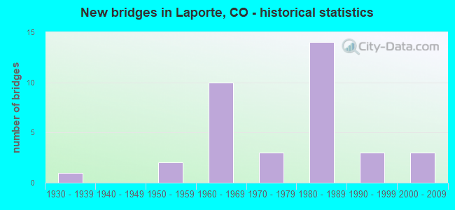
- New bridges - historical statistics
- 11930-1939
- 21950-1959
- 101960-1969
- 31970-1979
- 141980-1989
- 31990-1999
- 32000-2009

- Reconstructed bridges - Historical Statistics
- 11970-1979
- 01980-1989
- 01990-1999
- 12000-2009
- 12010-2019
- 22020-2022


- Bridge Condition - Deck
- 8.3%Very good
- 25.0%Good
- 54.2%Satisfactory
- 8.3%Fair
- 4.2%Poor

- Bridge Condition - Superstructure
- 8.3%Very good
- 25.0%Good
- 62.5%Satisfactory
- 4.2%Poor

- Bridge Condition - Substructure
- 45.8%Good
- 41.7%Satisfactory
- 8.3%Fair
- 4.2%Poor

- Bridge Condition - Channel
- 37.1%Very good
- 42.9%Good
- 20.0%Satisfactory

- Bridge Condition - Culverts
- 25.0%Good
- 66.7%Satisfactory
- 8.3%Fair
Find on map >> Show street view
Structure Number: B-16-AI, Location: 1.3 MI N OF JCT SH 14 (Lat: 40.676919, Lng: -105.179744), Route carried "on" structure: US 287C, Year Built: 1966, Status: Open, Structure Length: 2.63m (8.63ft), Average Daily Traffic: 6,500 (year 2020), Truck Traffic: 15%, Average Future Daily Traffic: 7,410 (year 2040), Design Load: HS 20+Mod, Features Intersected: HOOK AND MOOR GLADE, Facility Carried by Structure: US 287 ML
Minimum Vertical Clearance: 30+ m (98+ ft), Kilometerpoint: 119.695, Lanes on structure: 2, Base Highway Network: Yes, Owner: State Highway Agency, Approaching Roadway Width: 11.0m (36.1ft), Skew: 5 degrees, Material/Design: Concrete, Design/Construction: Tee Beam, Number Of Spans In Main Unit: 3, Length of Maximum Span: 8.5m (27.9ft), Curb-To-Curb Width: 11.9m (39.0ft), Out-to-Out Width: 12.8m (42.0ft)
Condition: Deck: Satisfactory, Superstructure: Satisfactory, Substructure: Satisfactory, Channel: Very good, Operating Rating: 52.2 metric tons, Method Used To Determine Operating Rating: Load Factor (LF), Inventory Rating: 31.2 metric tons, Method Used To Determine Inventory Rating: Load Factor (LF), Structural Evaluation: Equal to present minimum criteria, Deck Geometry: Somewhat better than minimum adequacy, Waterway Adequacy: Equal to present desirable criteria, Approach Roadway Alignment: Equal to present desirable criteria, Designated Inspection Frequency: Every 24 months, Inspection Date: November 2021, Deck Structure Type: Other, Wearing Surface/Protective System: Wearing Surface: Bituminous
Find on map >> Show street view
Structure Number: B-16-CP, Location: 2.5 MI N OF JCT SH 14 (Lat: 40.694722, Lng: -105.174861), Route carried "on" structure: US 287C, Year Built: 1967, Status: Open, Structure Length: 0.91m (2.99ft), Average Daily Traffic: 6,500 (year 2020), Truck Traffic: 15%, Average Future Daily Traffic: 7,410 (year 2040), Design Load: HS 20, Features Intersected: DRAW, Facility Carried by Structure: US 287 ML
Minimum Vertical Clearance: 30+ m (98+ ft), Kilometerpoint: 121.723, Lanes on structure: 2, Base Highway Network: Yes, Owner: State Highway Agency, Approaching Roadway Width: 11.6m (38.1ft), Skew: 4 degrees, Material/Design: Concrete, Design/Construction: Culvert, Number Of Spans In Main Unit: 2, Length of Maximum Span: 4.3m (14.1ft), Curb-To-Curb Width: 11.6m (38.1ft), Out-to-Out Width: 15.0m (49.2ft)
Condition: Channel: Good, Culverts: Satisfactory, Operating Rating: 36.3 metric tons, Method Used To Determine Operating Rating: Field evaluation and documented engineering judgment, Inventory Rating: 32.7 metric tons, Method Used To Determine Inventory Rating: Field evaluation and documented engineering judgment, Structural Evaluation: Equal to present minimum criteria, Deck Geometry: Somewhat better than minimum adequacy, Waterway Adequacy: Equal to present desirable criteria, Approach Roadway Alignment: Equal to present desirable criteria, Designated Inspection Frequency: Every 24 months, Inspection Date: September 2021
Find on map >> Show street view
Structure Number: B-16-FU, Location: 1.7 MI W OF 287-TEDS PLAC (Lat: 40.665197, Lng: -105.221336), Route carried "on" structure: State highway 14B, Year Built: 1984, Status: Open, Structure Length: 1.82m (5.97ft), Average Daily Traffic: 2,100 (year 2020), Truck Traffic: 5%, Average Future Daily Traffic: 2,772 (year 2040), Design Load: HS 20, Features Intersected: POUDRE VALLEY CANAL, Facility Carried by Structure: SH 14 ML
Minimum Vertical Clearance: 30+ m (98+ ft), Kilometerpoint: 139.369, Lanes on structure: 2, Base Highway Network: Yes, Owner: State Highway Agency, Approaching Roadway Width: 7.9m (25.9ft), Skew: 6 degrees, Material/Design: Concrete, Design/Construction: Culvert, Number Of Spans In Main Unit: 2, Length of Maximum Span: 8.8m (28.9ft), Curb-To-Curb Width: 17.1m (56.1ft), Out-to-Out Width: 17.7m (58.1ft)
Condition: Channel: Very good, Culverts: Satisfactory, Operating Rating: 36.3 metric tons, Method Used To Determine Operating Rating: Field evaluation and documented engineering judgment, Inventory Rating: 32.7 metric tons, Method Used To Determine Inventory Rating: Field evaluation and documented engineering judgment, Structural Evaluation: Equal to present minimum criteria, Deck Geometry: Superior to present desirable criteria, Waterway Adequacy: Equal to present desirable criteria, Approach Roadway Alignment: Equal to present desirable criteria, Designated Inspection Frequency: Every 48 months, Inspection Date: October 2021
Find on map >> Show street view
Structure Number: B-16-FX, Location: 3.6 MI S OF TEDS PLACE (Lat: 40.644886, Lng: -105.135508), Route carried "on" structure: US 287C, Year Built: 1987, Status: Open, Structure Length: 2.33m (7.64ft), Average Daily Traffic: 9,900 (year 2020), Truck Traffic: 12%, Average Future Daily Traffic: 10,989 (year 2040), Design Load: HS 20, Features Intersected: LARIMER COUNTY CANAL, Facility Carried by Structure: US287 ML
Minimum Vertical Clearance: 30+ m (98+ ft), Kilometerpoint: 111.209, Lanes on structure: 3, Base Highway Network: Yes, Owner: State Highway Agency, Approaching Roadway Width: 15.8m (51.8ft), Skew: 1 degrees, Material/Design: Prestressed concrete, Design/Construction: Box Beam or Girders - Single/Spread, Number Of Spans In Main Unit: 1, Length of Maximum Span: 22.5m (73.8ft), Curb-To-Curb Width: 15.2m (49.9ft), Out-to-Out Width: 16.0m (52.5ft)
Condition: Deck: Satisfactory, Superstructure: Good, Substructure: Good, Channel: Very good, Operating Rating: 59.4 metric tons, Method Used To Determine Operating Rating: Load Factor (LF), Inventory Rating: 31.2 metric tons, Method Used To Determine Inventory Rating: Load Factor (LF), Structural Evaluation: Better than present minimum criteria, Deck Geometry: Equal to present minimum criteria, Waterway Adequacy: Superior to present desirable criteria, Approach Roadway Alignment: Equal to present desirable criteria, Designated Inspection Frequency: Every 48 months, Inspection Date: November 2019, Deck Structure Type: Concrete Cast-file-Place, Wearing Surface/Protective System: Wearing Surface: Monolithic Concrete, Deck Protection: Epoxy Coated Reinforcing
Find on map >> Show street view
Structure Number: B-16-FY, Location: 1.6 MI S OF TEDS PLACE (Lat: 40.653269, Lng: -105.163550), Route carried "on" structure: US 287C, Year Built: 1987, Status: Open, Structure Length: 2.29m (7.51ft), Average Daily Traffic: 8,900 (year 2020), Truck Traffic: 12%, Average Future Daily Traffic: 10,235 (year 2040), Design Load: HS 20, Features Intersected: LARIMER COUNTY CANAL, Facility Carried by Structure: US287 ML
Minimum Vertical Clearance: 30+ m (98+ ft), Kilometerpoint: 114.714, Lanes on structure: 4, Base Highway Network: Yes, Owner: State Highway Agency, Approaching Roadway Width: 20.1m (65.9ft), Material/Design: Prestressed concrete, Design/Construction: Box Beam or Girders - Single/Spread, Number Of Spans In Main Unit: 1, Length of Maximum Span: 22.0m (72.2ft), Curb-To-Curb Width: 20.1m (65.9ft), Out-to-Out Width: 20.9m (68.6ft)
Condition: Deck: Satisfactory, Superstructure: Good, Substructure: Good, Channel: Very good, Operating Rating: 61.7 metric tons, Method Used To Determine Operating Rating: Load Factor (LF), Inventory Rating: 31.5 metric tons, Method Used To Determine Inventory Rating: Load Factor (LF), Structural Evaluation: Better than present minimum criteria, Deck Geometry: Better than present minimum criteria, Waterway Adequacy: Superior to present desirable criteria, Approach Roadway Alignment: Equal to present desirable criteria, Designated Inspection Frequency: Every 48 months, Inspection Date: November 2019, Deck Structure Type: Concrete Cast-file-Place, Wearing Surface/Protective System: Wearing Surface: Monolithic Concrete, Membrane: Preformed Fabric, Deck Protection: Epoxy Coated Reinforcing
Find on map >> Show street view
Structure Number: B-16-FZ, Location: 1.2 MI S OF TED'S PLACE (Lat: 40.650186, Lng: -105.171633), Route carried "on" structure: US 287C, Year Built: 1987, Status: Open, Structure Length: 1.64m (5.38ft), Average Daily Traffic: 8,900 (year 2020), Truck Traffic: 12%, Average Future Daily Traffic: 10,235 (year 2040), Features Intersected: DITCH, Facility Carried by Structure: FT COLLINS EXP WAY
Minimum Vertical Clearance: 30+ m (98+ ft), Kilometerpoint: 115.472, Lanes on structure: 7, Base Highway Network: Yes, Owner: State Highway Agency, Approaching Roadway Width: 23.2m (76.1ft), Skew: 15 degrees, Material/Design: Concrete, Design/Construction: Culvert, Number Of Spans In Main Unit: 4, Length of Maximum Span: 3.8m (12.5ft), Out-to-Out Width: 53.0m (173.9ft)
Condition: Channel: Good, Culverts: Satisfactory, Operating Rating: 89.8 metric tons, Method Used To Determine Operating Rating: Field evaluation and documented engineering judgment, Inventory Rating: 89.8 metric tons, Method Used To Determine Inventory Rating: Field evaluation and documented engineering judgment, Structural Evaluation: Equal to present minimum criteria, Waterway Adequacy: Equal to present desirable criteria, Approach Roadway Alignment: Equal to present desirable criteria, Designated Inspection Frequency: Every 48 months, Inspection Date: November 2021
Find on map >> Show street view
Structure Number: B-16-GA, Location: 2.5 MI NW OF FT COLLINS (Lat: 40.633042, Lng: -105.113867), Route carried "on" structure: US 287C, Year Built: 1988, Status: Open, Structure Length: 6.13m (20.11ft), Average Daily Traffic: 9,900 (year 2020), Truck Traffic: 12%, Average Future Daily Traffic: 10,989 (year 2040), Design Load: HS 20+Mod, Features Intersected: COUNTY ROAD 19, Facility Carried by Structure: US 287 ML
Minimum Vertical Clearance: 30+ m (98+ ft), Kilometerpoint: 108.919, Lanes on structure: 2, Lanes under structure: 2, Base Highway Network: Yes, Owner: State Highway Agency, Approaching Roadway Width: 12.8m (42.0ft), Skew: 5 degrees, Material/Design: Prestressed concrete continuous, Design/Construction: Stringer/Multi-beam, Number Of Spans In Main Unit: 3, Length of Maximum Span: 31.9m (104.7ft), Curb-To-Curb Width: 12.8m (42.0ft), Out-to-Out Width: 13.6m (44.6ft)
Condition: Deck: Good, Superstructure: Good, Substructure: Good, Operating Rating: 57.9 metric tons, Method Used To Determine Operating Rating: Load Factor (LF), Inventory Rating: 32.4 metric tons, Method Used To Determine Inventory Rating: Load Factor (LF), Structural Evaluation: Better than present minimum criteria, Deck Geometry: Somewhat better than minimum adequacy, Underclear: Better than present minimum criteria, Approach Roadway Alignment: Equal to present desirable criteria, Designated Inspection Frequency: Every 24 months, Inspection Date: September 2021, Deck Structure Type: Concrete Cast-file-Place, Wearing Surface/Protective System: Wearing Surface: Bituminous, Membrane: Preformed Fabric, Deck Protection: Epoxy Coated Reinforcing
Find on map >> Show street view
Structure Number: B-16-GB, Location: NW OF FT. COLLINS (Lat: 40.625322, Lng: -105.100992), Route carried "on" structure: US 287C, Year Built: 1987, Status: Open, Structure Length: 0.78m (2.56ft), Average Daily Traffic: 9,900 (year 2020), Truck Traffic: 12%, Average Future Daily Traffic: 10,989 (year 2040), Features Intersected: Little Cache La Poudre D, Facility Carried by Structure: US 287 ML
Minimum Vertical Clearance: 30+ m (98+ ft), Kilometerpoint: 107.461, Lanes on structure: 2, Base Highway Network: Yes, Owner: State Highway Agency, Approaching Roadway Width: 12.8m (42.0ft), Skew: 3 degrees, Material/Design: Concrete, Design/Construction: Culvert, Number Of Spans In Main Unit: 1, Length of Maximum Span: 7.8m (25.6ft), Out-to-Out Width: 106.2m (348.4ft)
Condition: Channel: Good, Culverts: Good, Operating Rating: 36.3 metric tons, Method Used To Determine Operating Rating: Field evaluation and documented engineering judgment, Inventory Rating: 32.7 metric tons, Method Used To Determine Inventory Rating: Field evaluation and documented engineering judgment, Structural Evaluation: Better than present minimum criteria, Waterway Adequacy: Equal to present desirable criteria, Approach Roadway Alignment: Equal to present desirable criteria, Designated Inspection Frequency: Every 48 months, Inspection Date: November 2019
Find on map >> Show street view
Structure Number: B-16-GJ, Location: 0.8 MI S OF JCT SH 14 (Lat: 40.654261, Lng: -105.179728), Route carried "on" structure: US 287C, Year Built: 1991, Status: Open, Structure Length: 2.51m (8.23ft), Average Daily Traffic: 8,900 (year 2020), Truck Traffic: 12%, Average Future Daily Traffic: 10,235 (year 2040), Design Load: HS 20, Features Intersected: LARIMER COUNTY CANAL, Facility Carried by Structure: US 287 ML
Minimum Vertical Clearance: 30+ m (98+ ft), Kilometerpoint: 116.341, Lanes on structure: 4, Base Highway Network: Yes, Owner: State Highway Agency, Approaching Roadway Width: 23.2m (76.1ft), Skew: 16 degrees, Material/Design: Concrete, Design/Construction: Culvert, Number Of Spans In Main Unit: 2, Length of Maximum Span: 12.1m (39.7ft), Curb-To-Curb Width: 31.7m (104.0ft), Out-to-Out Width: 32.5m (106.6ft)
Condition: Channel: Very good, Culverts: Satisfactory, Operating Rating: 36.3 metric tons, Method Used To Determine Operating Rating: Field evaluation and documented engineering judgment, Inventory Rating: 32.7 metric tons, Method Used To Determine Inventory Rating: Field evaluation and documented engineering judgment, Structural Evaluation: Equal to present minimum criteria, Deck Geometry: Superior to present desirable criteria, Waterway Adequacy: Equal to present desirable criteria, Approach Roadway Alignment: Equal to present desirable criteria, Designated Inspection Frequency: Every 48 months, Inspection Date: November 2021
Find on map >> Show street view
Structure Number: B-16-R, Location: 0.1 MI N OF JCT SH 14 (Lat: 40.664856, Lng: -105.188992), Route carried "on" structure: US 287C, Year Built: 1965, Status: Open, Structure Length: 1.22m (4.00ft), Average Daily Traffic: 6,500 (year 2020), Truck Traffic: 15%, Average Future Daily Traffic: 7,410 (year 2040), Design Load: HS 20, Features Intersected: LARAMIE POUDRE CANAL, Facility Carried by Structure: US 287 ML
Minimum Vertical Clearance: 30+ m (98+ ft), Kilometerpoint: 117.781, Lanes on structure: 4, Base Highway Network: Yes, Owner: State Highway Agency, Approaching Roadway Width: 23.2m (76.1ft), Skew: 14 degrees, Material/Design: Concrete, Design/Construction: Slab, Number Of Spans In Main Unit: 1, Length of Maximum Span: 11.3m (37.1ft), Curb-To-Curb Width: 23.2m (76.1ft), Out-to-Out Width: 36.2m (118.8ft)
Condition: Deck: Satisfactory, Superstructure: Satisfactory, Substructure: Good, Channel: Very good, Operating Rating: 37.6 metric tons, Method Used To Determine Operating Rating: Load Factor (LF), Inventory Rating: 22.5 metric tons, Method Used To Determine Inventory Rating: Load Factor (LF), Structural Evaluation: Somewhat better than minimum adequacy, Deck Geometry: Superior to present desirable criteria, Waterway Adequacy: Better than present minimum criteria, Approach Roadway Alignment: Equal to present desirable criteria, Designated Inspection Frequency: Every 24 months, Inspection Date: November 2021
Find on map >> Show street view
Structure Number: LR17-0.2-54, Location: 0.2 Mi No of Co Rd 54 (Lat: 40.643000, Lng: -105.095083), Route carried "on" structure: County highway , Year Built: 1986, Status: Open, Structure Length: 0.62m (2.03ft), Average Daily Traffic: 1,939 (year 2021), Truck Traffic: 16%, Average Future Daily Traffic: 2,424 (year 2041), Design Load: HS 20, Features Intersected: Jackson Ditch, Facility Carried by Structure: County Road 17
Minimum Vertical Clearance: 30+ m (98+ ft), Kilometerpoint: 1.978, Lanes on structure: 2, Owner: County Highway Agency, Approaching Roadway Width: 7.3m (24.0ft), Skew: 4 degrees, Material/Design: Steel, Design/Construction: Culvert, Number Of Spans In Main Unit: 1, Length of Maximum Span: 6.2m (20.3ft), Out-to-Out Width: 20.9m (68.6ft)
Condition: Channel: Good, Culverts: Satisfactory, Operating Rating: 43.6 metric tons, Method Used To Determine Operating Rating: Load Factor (LF), Inventory Rating: 32.7 metric tons, Method Used To Determine Inventory Rating: Load Factor (LF), Structural Evaluation: Equal to present minimum criteria, Waterway Adequacy: Better than present minimum criteria, Approach Roadway Alignment: Equal to present desirable criteria, Designated Inspection Frequency: Every 24 months, Inspection Date: March 2021
Find on map >> Show street view
Structure Number: LR17-0.3-S287, Location: 0.3 Mi N of US Hwy 287 (Lat: 40.630500, Lng: -105.095278), Route carried "on" structure: County highway , Year Built: 1987, Status: Open, Structure Length: 0.64m (2.10ft), Average Daily Traffic: 6,771 (year 2021), Truck Traffic: 14%, Average Future Daily Traffic: 8,464 (year 2041), Design Load: HS 20, Features Intersected: Dry Creek, Facility Carried by Structure: North Shields St.
Minimum Vertical Clearance: 30+ m (98+ ft), Kilometerpoint: 0.575, Lanes on structure: 2, Owner: County Highway Agency, Approaching Roadway Width: 9.1m (29.9ft), Material/Design: Concrete, Design/Construction: Culvert, Number Of Spans In Main Unit: 2, Length of Maximum Span: 3.0m (9.8ft), Curb-To-Curb Width: 11.0m (36.1ft), Out-to-Out Width: 11.7m (38.4ft)
Condition: Channel: Good, Culverts: Good, Operating Rating: 37.5 metric tons, Method Used To Determine Operating Rating: Load Factor (LF), Inventory Rating: 22.4 metric tons, Method Used To Determine Inventory Rating: Load Factor (LF), Structural Evaluation: Somewhat better than minimum adequacy, Deck Geometry: Meets minimum limits, Waterway Adequacy: Equal to present desirable criteria, Approach Roadway Alignment: Equal to present desirable criteria, Designated Inspection Frequency: Every 24 months, Inspection Date: June 2021
Find on map >> Show street view
Structure Number: LR17-0.5-S287, Location: 0.5 Mi N of US Hwy 287 (Lat: 40.632972, Lng: -105.095222), Route carried "on" structure: County highway , Year Built: 1962, Status: Open, Structure Length: 0.70m (2.30ft), Average Daily Traffic: 5,304 (year 2021), Truck Traffic: 16%, Average Future Daily Traffic: 6,630 (year 2041), Features Intersected: Terry Lake Inlet Canal, Facility Carried by Structure: N Shields St-CR17
Minimum Vertical Clearance: 30+ m (98+ ft), Kilometerpoint: 0.852, Lanes on structure: 2, Owner: County Highway Agency, Approaching Roadway Width: 9.1m (29.9ft), Skew: 1 degrees, Material/Design: Prestressed concrete, Design/Construction: Tee Beam, Number Of Spans In Main Unit: 1, Length of Maximum Span: 6.1m (20.0ft), Curb-To-Curb Width: 8.9m (29.2ft), Out-to-Out Width: 9.2m (30.2ft)
Condition: Deck: Satisfactory, Superstructure: Poor, Substructure: Satisfactory, Channel: Good, Operating Rating: 22.1 metric tons, Method Used To Determine Operating Rating: Load Factor (LF), Inventory Rating: 13.2 metric tons, Method Used To Determine Inventory Rating: Load Factor (LF), Structural Evaluation: High priority of corrective action, Deck Geometry: High priority of replacement, Waterway Adequacy: Equal to present desirable criteria, Approach Roadway Alignment: Equal to present desirable criteria, Designated Inspection Frequency: Every 24 months, Inspection Date: March 2021, Deck Structure Type: Other, Wearing Surface/Protective System: Wearing Surface: Bituminous
Find on map >> Show street view
Structure Number: LR19-1.1-48-A, Location: 1.1 Mi N of Co Rd 48 (Lat: 40.612139, Lng: -105.114333), Route carried "on" structure: County highway , Year Built: 2003, Status: Open, Structure Length: 7.32m (24.02ft), Average Daily Traffic: 7,586 (year 2021), Truck Traffic: 13%, Average Future Daily Traffic: 9,483 (year 2041), Design Load: HS 20, Features Intersected: Cache La Poudre River, Facility Carried by Structure: County Road 19
Minimum Vertical Clearance: 30+ m (98+ ft), Kilometerpoint: 2.143, Lanes on structure: 2, Owner: County Highway Agency, Approaching Roadway Width: 12.2m (40.0ft), Skew: 4 degrees, Material/Design: Prestressed concrete continuous, Design/Construction: Tee Beam, Number Of Spans In Main Unit: 2, Length of Maximum Span: 34.7m (113.8ft), Curb-To-Curb Width: 12.3m (40.4ft), Out-to-Out Width: 13.2m (43.3ft)
Condition: Deck: Good, Superstructure: Very good, Substructure: Good, Channel: Very good, Operating Rating: 81.5 metric tons, Method Used To Determine Operating Rating: Load Factor (LF), Inventory Rating: 53.8 metric tons, Method Used To Determine Inventory Rating: Load Factor (LF), Structural Evaluation: Better than present minimum criteria, Deck Geometry: Somewhat better than minimum adequacy, Waterway Adequacy: Equal to present desirable criteria, Approach Roadway Alignment: Better than present minimum criteria, Designated Inspection Frequency: Every 24 months, Inspection Date: April 2021, Deck Structure Type: Concrete Cast-file-Place, Wearing Surface/Protective System: Wearing Surface: Bituminous, Membrane: Preformed Fabric, Deck Protection: Epoxy Coated Reinforcing
Find on map >> Show street view
Structure Number: LR19-1.2-48, Location: 1.2 Mi. N. of Co. Rd. 48 (Lat: 40.613500, Lng: -105.113944), Route carried "on" structure: County highway , Year Built: 2003, Status: Open, Structure Length: 1.88m (6.17ft), Average Daily Traffic: 7,391 (year 2021), Truck Traffic: 11%, Average Future Daily Traffic: 9,239 (year 2041), Design Load: HS 20, Features Intersected: Cache La Poudre Overflow, Facility Carried by Structure: County Road 19
Minimum Vertical Clearance: 30+ m (98+ ft), Kilometerpoint: 2.300, Lanes on structure: 2, Owner: County Highway Agency, Approaching Roadway Width: 14.6m (47.9ft), Material/Design: Concrete, Design/Construction: Frame, Number Of Spans In Main Unit: 2, Length of Maximum Span: 9.1m (29.9ft), Curb-To-Curb Width: 14.7m (48.2ft), Out-to-Out Width: 15.6m (51.2ft)
Condition: Deck: Satisfactory, Superstructure: Satisfactory, Substructure: Satisfactory, Channel: Good, Operating Rating: 52.3 metric tons, Method Used To Determine Operating Rating: Load Factor (LF), Inventory Rating: 31.3 metric tons, Method Used To Determine Inventory Rating: Load Factor (LF), Structural Evaluation: Equal to present minimum criteria, Deck Geometry: Superior to present desirable criteria, Waterway Adequacy: Equal to present desirable criteria, Approach Roadway Alignment: Equal to present desirable criteria, Designated Inspection Frequency: Every 24 months, Inspection Date: March 2021, Deck Structure Type: Other, Wearing Surface/Protective System: Wearing Surface: Bituminous
Find on map >> Show street view
Structure Number: LR19-2.0-56, Location: 2.0 Mi N of Co Rd 56 (Lat: 40.683278, Lng: -105.113222), Route carried "on" structure: County highway , Year Built: 1979, Status: Open, Structure Length: 1.39m (4.56ft), Average Daily Traffic: 3,197 (year 2021), Truck Traffic: 22%, Average Future Daily Traffic: 3,996 (year 2041), Design Load: HS 20, Features Intersected: Larimer County Canal, Facility Carried by Structure: County Road 19
Minimum Vertical Clearance: 30+ m (98+ ft), Kilometerpoint: 10.029, Lanes on structure: 2, Owner: County Highway Agency, Approaching Roadway Width: 9.1m (29.9ft), Material/Design: Prestressed concrete, Design/Construction: Tee Beam, Number Of Spans In Main Unit: 1, Length of Maximum Span: 13.1m (43.0ft), Curb or Sidewalk Widths: Left: 1.8m (5.9ft), Right: 0.0m, Curb-To-Curb Width: 12.1m (39.7ft), Out-to-Out Width: 14.8m (48.6ft)
Condition: Deck: Fair, Superstructure: Satisfactory, Substructure: Good, Channel: Satisfactory, Operating Rating: 41.2 metric tons, Method Used To Determine Operating Rating: Load Factor (LF), Inventory Rating: 25.5 metric tons, Method Used To Determine Inventory Rating: Load Factor (LF), Structural Evaluation: Equal to present minimum criteria, Deck Geometry: Somewhat better than minimum adequacy, Waterway Adequacy: Equal to present desirable criteria, Approach Roadway Alignment: Equal to present desirable criteria, Designated Inspection Frequency: Every 24 months, Inspection Date: March 2021, Deck Structure Type: Other, Wearing Surface/Protective System: Wearing Surface: Bituminous
Find on map >> Show street view
Structure Number: LR21-1.3-60E, Location: 1.3 Mi N of Co Rd 60E (Lat: 40.708250, Lng: -105.133722), Route carried "on" structure: County highway , Year Built: 1972, Status: Open, Structure Length: 0.88m (2.89ft), Average Daily Traffic: 58 (year 2021), Truck Traffic: 19%, Average Future Daily Traffic: 73 (year 2041), Features Intersected: Poudre Valley Canal, Facility Carried by Structure: County Road 21
Minimum Vertical Clearance: 30+ m (98+ ft), Kilometerpoint: 2.850, Lanes on structure: 2, Owner: County Highway Agency, Approaching Roadway Width: 6.7m (22.0ft), Skew: 1 degrees, Material/Design: Wood or Timber, Design/Construction: Stringer/Multi-beam, Number Of Spans In Main Unit: 1, Length of Maximum Span: 7.9m (25.9ft), Curb-To-Curb Width: 7.1m (23.3ft), Out-to-Out Width: 7.3m (24.0ft)
Condition: Deck: Very good, Superstructure: Satisfactory, Substructure: Good, Channel: Good, Operating Rating: 38.6 metric tons, Method Used To Determine Operating Rating: Allowable Stress (AS), Inventory Rating: 25.4 metric tons, Method Used To Determine Inventory Rating: Allowable Stress (AS), Structural Evaluation: Equal to present minimum criteria, Deck Geometry: Somewhat better than minimum adequacy, Waterway Adequacy: Equal to present desirable criteria, Approach Roadway Alignment: Equal to present desirable criteria, Designated Inspection Frequency: Every 24 months, Inspection Date: March 2021, Deck Structure Type: Corrugated Steel, Wearing Surface/Protective System: Wearing Surface: Bituminous
Find on map >> Show street view
Structure Number: LR21C-0.2-50-A, Location: 0.2 Mi N of Co Rd 50 (Lat: 40.614028, Lng: -105.140139), Route carried "on" structure: County highway , Year Built: 1983, Status: Open, Structure Length: 0.69m (2.26ft), Average Daily Traffic: 5,590 (year 2021), Truck Traffic: 20%, Average Future Daily Traffic: 6,988 (year 2041), Design Load: HS 20+Mod, Features Intersected: New Mercer Canal, Facility Carried by Structure: County Road 21C
Minimum Vertical Clearance: 30+ m (98+ ft), Kilometerpoint: 0.358, Lanes on structure: 2, Owner: County Highway Agency, Approaching Roadway Width: 9.1m (29.9ft), Skew: 3 degrees, Material/Design: Aluminum, Iron, Design/Construction: Culvert, Number Of Spans In Main Unit: 1, Length of Maximum Span: 6.9m (22.6ft), Out-to-Out Width: 13.9m (45.6ft)
Condition: Channel: Good, Culverts: Satisfactory, Inventory Rating: 93.9 metric tons, Method Used To Determine Inventory Rating: Load Factor (LF), Structural Evaluation: Equal to present minimum criteria, Waterway Adequacy: Equal to present desirable criteria, Approach Roadway Alignment: Somewhat better than minimum adequacy, Designated Inspection Frequency: Every 24 months, Inspection Date: March 2021
Find on map >> Show street view
Structure Number: LR21C-0.2-50E, Location: 0.2 Mi N of Co Rd 50E (Lat: 40.620778, Lng: -105.139611), Route carried "on" structure: County highway , Year Built: 1976, Status: Open, Structure Length: 4.92m (16.14ft), Average Daily Traffic: 4,537 (year 2021), Truck Traffic: 16%, Average Future Daily Traffic: 5,671 (year 2041), Features Intersected: Cache La Poudre River, Facility Carried by Structure: County Road 21C
Minimum Vertical Clearance: 30+ m (98+ ft), Kilometerpoint: 1.114, Lanes on structure: 2, Owner: County Highway Agency, Approaching Roadway Width: 11.0m (36.1ft), Skew: 3 degrees, Material/Design: Prestressed concrete, Design/Construction: Tee Beam, Number Of Spans In Main Unit: 2, Length of Maximum Span: 23.4m (76.8ft), Curb or Sidewalk Widths: Left: 1.5m (4.9ft), Right: 1.6m (5.2ft), Curb-To-Curb Width: 11.0m (36.1ft), Out-to-Out Width: 14.6m (47.9ft)
Condition: Deck: Satisfactory, Superstructure: Satisfactory, Substructure: Fair, Channel: Good, Operating Rating: 42.7 metric tons, Method Used To Determine Operating Rating: Load Factor (LF), Inventory Rating: 13.2 metric tons, Method Used To Determine Inventory Rating: Load Factor (LF), Structural Evaluation: Meets minimum limits, Deck Geometry: Somewhat better than minimum adequacy, Waterway Adequacy: Equal to present desirable criteria, Approach Roadway Alignment: Equal to present desirable criteria, Designated Inspection Frequency: Every 24 months, Inspection Date: April 2021, Deck Structure Type: Other, Wearing Surface/Protective System: Wearing Surface: Bituminous
Find on map >> Show street view
Structure Number: LR21C-0.3-50-A, Location: 0.3 Mi N of Co Rd 50 (Lat: 40.614861, Lng: -105.140361), Route carried "on" structure: County highway , Year Built: 1983, Status: Open, Structure Length: 0.70m (2.30ft), Average Daily Traffic: 5,597 (year 2021), Truck Traffic: 17%, Average Future Daily Traffic: 6,996 (year 2041), Design Load: HS 20+Mod, Features Intersected: Larimer Co. Canal No. 2, Facility Carried by Structure: County Road 21C
Minimum Vertical Clearance: 30+ m (98+ ft), Kilometerpoint: 0.451, Lanes on structure: 2, Owner: County Highway Agency, Approaching Roadway Width: 9.1m (29.9ft), Skew: 3 degrees, Material/Design: Aluminum, Iron, Design/Construction: Culvert, Number Of Spans In Main Unit: 1, Length of Maximum Span: 7.0m (23.0ft), Out-to-Out Width: 21.2m (69.6ft)
Condition: Channel: Satisfactory, Culverts: Satisfactory, Inventory Rating: 91.2 metric tons, Method Used To Determine Inventory Rating: Load Factor (LF), Structural Evaluation: Equal to present minimum criteria, Waterway Adequacy: Equal to present desirable criteria, Approach Roadway Alignment: Equal to present minimum criteria, Designated Inspection Frequency: Every 24 months, Inspection Date: March 2021
Find on map >> Show street view
Structure Number: LR21C-0.4-54G-A, Location: 0.4 Mi N of Co Rd 54G (Lat: 40.632639, Lng: -105.137972), Route carried "on" structure: County highway , Year Built: 1986, Status: Open, Structure Length: 0.75m (2.46ft), Average Daily Traffic: 1,210 (year 2021), Truck Traffic: 24%, Average Future Daily Traffic: 1,513 (year 2041), Features Intersected: Jackson Ditch, Facility Carried by Structure: County Road 21C
Minimum Vertical Clearance: 30+ m (98+ ft), Kilometerpoint: 0.624, Lanes on structure: 2, Owner: County Highway Agency, Approaching Roadway Width: 9.1m (29.9ft), Skew: 4 degrees, Material/Design: Steel, Design/Construction: Culvert, Number Of Spans In Main Unit: 1, Length of Maximum Span: 7.5m (24.6ft), Out-to-Out Width: 20.8m (68.2ft)
Condition: Channel: Satisfactory, Culverts: Fair, Operating Rating: 96.9 metric tons, Method Used To Determine Operating Rating: Load and Resistance Factor Rating (LRFR) rating reported by rating factor(RF) method using HL-93 loadings, Inventory Rating: 82.0 metric tons, Method Used To Determine Inventory Rating: Load and Resistance Factor Rating (LRFR) rating reported by rating factor(RF) method using HL-93 loadings, Structural Evaluation: Somewhat better than minimum adequacy, Waterway Adequacy: Equal to present minimum criteria, Approach Roadway Alignment: Equal to present desirable criteria, Designated Inspection Frequency: Every 24 months, Inspection Date: March 2021
Find on map >> Show street view
Structure Number: LR21C-1.0-54G-A, Location: 1.0 Mi N of Co Rd 54G (Lat: 40.641528, Lng: -105.137528), Route carried "on" structure: County highway , Year Built: 1990, Status: Open, Structure Length: 1.83m (6.00ft), Average Daily Traffic: 1,063 (year 2021), Truck Traffic: 26%, Average Future Daily Traffic: 1,329 (year 2041), Design Load: HS 20, Features Intersected: Larimer County Canal, Facility Carried by Structure: CR21C/OVERLAND TRL
Minimum Vertical Clearance: 30+ m (98+ ft), Kilometerpoint: 1.534, Lanes on structure: 2, Owner: County Highway Agency, Approaching Roadway Width: 8.2m (26.9ft), Material/Design: Prestressed concrete, Design/Construction: Box Beam or Girders - Single/Spread, Number Of Spans In Main Unit: 1, Length of Maximum Span: 16.8m (55.1ft), Curb-To-Curb Width: 12.2m (40.0ft), Out-to-Out Width: 13.0m (42.7ft)
Condition: Deck: Good, Superstructure: Good, Substructure: Good, Channel: Good, Operating Rating: 56.3 metric tons, Method Used To Determine Operating Rating: Load Factor (LF), Inventory Rating: 31.1 metric tons, Method Used To Determine Inventory Rating: Load Factor (LF), Structural Evaluation: Better than present minimum criteria, Deck Geometry: Better than present minimum criteria, Waterway Adequacy: Equal to present desirable criteria, Approach Roadway Alignment: Equal to present desirable criteria, Designated Inspection Frequency: Every 24 months, Inspection Date: March 2021, Deck Structure Type: Concrete Cast-file-Place, Wearing Surface/Protective System: Wearing Surface: Bituminous, Membrane: Preformed Fabric, Deck Protection: Epoxy Coated Reinforcing
Find on map >> Show street view
Structure Number: LR25E-1.3-52E, Location: 1.3 Mi N of Co Rd 52E (Lat: 40.647278, Lng: -105.186750), Route carried "on" structure: County highway , Year Built: 1963, Status: Posted for load, Structure Length: 0.70m (2.30ft), Average Daily Traffic: 504 (year 2021), Truck Traffic: 17%, Average Future Daily Traffic: 630 (year 2041), Features Intersected: Pleas Valley Lake Canal, Facility Carried by Structure: County Road 25E
Minimum Vertical Clearance: 30+ m (98+ ft), Kilometerpoint: 4.280, Lanes on structure: 2, Owner: County Highway Agency, Approaching Roadway Width: 6.7m (22.0ft), Material/Design: Prestressed concrete, Design/Construction: Tee Beam, Number Of Spans In Main Unit: 1, Length of Maximum Span: 6.2m (20.3ft), Curb-To-Curb Width: 8.7m (28.5ft), Out-to-Out Width: 9.2m (30.2ft)
Condition: Deck: Satisfactory, Superstructure: Satisfactory, Substructure: Satisfactory, Channel: Good, Operating Rating: 22.7 metric tons, Method Used To Determine Operating Rating: Field evaluation and documented engineering judgment, Inventory Rating: 22.7 metric tons, Method Used To Determine Inventory Rating: Field evaluation and documented engineering judgment, Structural Evaluation: Equal to present minimum criteria, Deck Geometry: Somewhat better than minimum adequacy, Waterway Adequacy: Equal to present desirable criteria, Approach Roadway Alignment: Equal to present desirable criteria, Bridge Posting: Required (Relationship of Operating Rating to Maximum Legal Load: 0.1 - 9.9% below), Designated Inspection Frequency: Every 24 months, Inspection Date: March 2021, Deck Structure Type: Other, Wearing Surface/Protective System: Wearing Surface: Bituminous
Find on map >> Show street view
Structure Number: LR25G-S0.2-23, Location: 0.2 Mi W of Co Rd 23 (Lat: 40.609278, Lng: -105.178028), Route carried "on" structure: County highway , Year Built: 1960, Status: Open, Structure Length: 1.31m (4.30ft), Average Daily Traffic: 1,456 (year 2021), Truck Traffic: 10%, Average Future Daily Traffic: 1,820 (year 2041), Features Intersected: Hansen Feeder Canal, Facility Carried by Structure: County Road 25G
Minimum Vertical Clearance: 30+ m (98+ ft), Kilometerpoint: 2.277, Lanes on structure: 2, Owner: County Highway Agency, Approaching Roadway Width: 7.3m (24.0ft), Material/Design: Prestressed concrete, Design/Construction: Tee Beam, Number Of Spans In Main Unit: 1, Length of Maximum Span: 12.0m (39.4ft), Curb-To-Curb Width: 8.4m (27.6ft), Out-to-Out Width: 8.5m (27.9ft)
Condition: Deck: Satisfactory, Superstructure: Satisfactory, Substructure: Satisfactory, Channel: Very good, Operating Rating: 36.3 metric tons, Method Used To Determine Operating Rating: Field evaluation and documented engineering judgment, Inventory Rating: 32.7 metric tons, Method Used To Determine Inventory Rating: Field evaluation and documented engineering judgment, Structural Evaluation: Equal to present minimum criteria, Deck Geometry: Meets minimum limits, Waterway Adequacy: Equal to present desirable criteria, Approach Roadway Alignment: Equal to present desirable criteria, Designated Inspection Frequency: Every 24 months, Inspection Date: March 2021, Deck Structure Type: Other, Wearing Surface/Protective System: Wearing Surface: Bituminous
Find on map >> Show street view
Structure Number: LR27E-0.0-52E, Location: 100 Ft N of Co Rd 52E (Lat: 40.634444, Lng: -105.200111), Route carried "on" structure: County highway , Year Built: 1984, Status: Open, Structure Length: 0.63m (2.07ft), Average Daily Traffic: 150 (year 2021), Truck Traffic: 34%, Average Future Daily Traffic: 188 (year 2041), Design Load: HS 20, Features Intersected: Rist Creek, Facility Carried by Structure: County Road 27E
Minimum Vertical Clearance: 30+ m (98+ ft), Kilometerpoint: 0.049, Lanes on structure: 2, Owner: County Highway Agency, Approaching Roadway Width: 6.1m (20.0ft), Skew: 2 degrees, Material/Design: Concrete, Design/Construction: Culvert, Number Of Spans In Main Unit: 2, Length of Maximum Span: 3.0m (9.8ft), Curb-To-Curb Width: 11.4m (37.4ft), Out-to-Out Width: 12.4m (40.7ft)
Condition: Channel: Good, Culverts: Satisfactory, Operating Rating: 68.4 metric tons, Method Used To Determine Operating Rating: Load Factor (LF), Inventory Rating: 40.9 metric tons, Method Used To Determine Inventory Rating: Load Factor (LF), Structural Evaluation: Equal to present minimum criteria, Deck Geometry: Superior to present desirable criteria, Waterway Adequacy: Better than present minimum criteria, Approach Roadway Alignment: Equal to present desirable criteria, Designated Inspection Frequency: Every 24 months, Inspection Date: May 2021
Find on map >> Show street view
Structure Number: LR29C-0.0-S14, Location: 150 Ft N of St Hwy 14 (Lat: 40.665444, Lng: -105.209528), Route carried "on" structure: County highway , Year Built: 1960, Status: Open, Structure Length: 1.65m (5.41ft), Average Daily Traffic: 290 (year 2021), Truck Traffic: 32%, Average Future Daily Traffic: 363 (year 2041), Features Intersected: Poudre Valley Canal, Facility Carried by Structure: County Road 29C
Minimum Vertical Clearance: 30+ m (98+ ft), Kilometerpoint: 0.036, Lanes on structure: 2, Owner: County Highway Agency, Approaching Roadway Width: 9.1m (29.9ft), Skew: 1 degrees, Material/Design: Concrete, Design/Construction: Tee Beam, Number Of Spans In Main Unit: 1, Number Of Approach Spans: 2, Length of Maximum Span: 9.1m (29.9ft), Curb or Sidewalk Widths: Left: 0.3m (1.0ft), Right: 0.3m (1.0ft), Curb-To-Curb Width: 7.9m (25.9ft), Out-to-Out Width: 8.5m (27.9ft)
Condition: Deck: Satisfactory, Superstructure: Satisfactory, Substructure: Satisfactory, Channel: Satisfactory, Operating Rating: 36.3 metric tons, Method Used To Determine Operating Rating: Field evaluation and documented engineering judgment, Inventory Rating: 32.7 metric tons, Method Used To Determine Inventory Rating: Field evaluation and documented engineering judgment, Structural Evaluation: Equal to present minimum criteria, Deck Geometry: Somewhat better than minimum adequacy, Waterway Adequacy: Equal to present desirable criteria, Approach Roadway Alignment: Equal to present desirable criteria, Designated Inspection Frequency: Every 24 months, Inspection Date: March 2021, Deck Structure Type: Other, Wearing Surface/Protective System: Wearing Surface: Bituminous
Find on map >> Show street view
Structure Number: LR50E-1.7-23, Location: .2 Mi W of CR 21C (Lat: 40.618528, Lng: -105.142611), Route carried "on" structure: County highway , Year Built: 1962, Status: Open, Structure Length: 0.71m (2.33ft), Average Daily Traffic: 1,635 (year 2021), Truck Traffic: 16%, Average Future Daily Traffic: 2,044 (year 2041), Features Intersected: Larimer Co. Canal No. 2, Facility Carried by Structure: CO50E Bingham Hill
Minimum Vertical Clearance: 30+ m (98+ ft), Kilometerpoint: 2.845, Lanes on structure: 2, Owner: County Highway Agency, Approaching Roadway Width: 6.7m (22.0ft), Material/Design: Prestressed concrete, Design/Construction: Tee Beam, Number Of Spans In Main Unit: 1, Length of Maximum Span: 6.1m (20.0ft), Curb or Sidewalk Widths: Left: 0.2m (0.7ft), Right: 0.2m (0.7ft), Curb-To-Curb Width: 8.7m (28.5ft), Out-to-Out Width: 9.1m (29.9ft)
Condition: Deck: Fair, Superstructure: Satisfactory, Substructure: Satisfactory, Channel: Good, Operating Rating: 36.3 metric tons, Method Used To Determine Operating Rating: Field evaluation and documented engineering judgment, Inventory Rating: 32.7 metric tons, Method Used To Determine Inventory Rating: Field evaluation and documented engineering judgment, Structural Evaluation: Equal to present minimum criteria, Deck Geometry: Somewhat better than minimum adequacy, Waterway Adequacy: Equal to present desirable criteria, Approach Roadway Alignment: Equal to present desirable criteria, Designated Inspection Frequency: Every 24 months, Inspection Date: March 2021, Deck Structure Type: Other, Wearing Surface/Protective System: Wearing Surface: Bituminous
Find on map >> Show street view
Structure Number: LR52E-0.0-25E, Location: 0.0 Mi E of CR 25E (Lat: 40.629583, Lng: -105.181167), Route carried "on" structure: County highway , Year Built: 2007, Status: Open, Structure Length: 0.69m (2.26ft), Average Daily Traffic: 2,255 (year 2021), Truck Traffic: 18%, Average Future Daily Traffic: 2,819 (year 2041), Design Load: HS 20, Features Intersected: Pleas Valley Lake Canal, Facility Carried by Structure: County Road 52E
Minimum Vertical Clearance: 30+ m (98+ ft), Kilometerpoint: 24.496, Lanes on structure: 2, Owner: County Highway Agency, Approaching Roadway Width: 7.6m (24.9ft), Skew: 2 degrees, Material/Design: Concrete, Design/Construction: Culvert, Number Of Spans In Main Unit: 1, Length of Maximum Span: 6.9m (22.6ft), Out-to-Out Width: 19.7m (64.6ft)
Condition: Channel: Satisfactory, Culverts: Good, Operating Rating: 75.1 metric tons, Method Used To Determine Operating Rating: Load Factor (LF), Inventory Rating: 45.0 metric tons, Method Used To Determine Inventory Rating: Load Factor (LF), Structural Evaluation: Better than present minimum criteria, Waterway Adequacy: Equal to present minimum criteria, Approach Roadway Alignment: Equal to present desirable criteria, Designated Inspection Frequency: Every 24 months, Inspection Date: March 2021
Find on map >> Show street view
Structure Number: LR52E-0.1-23, Location: 0.1 Mi E of Co Rd 23 (Lat: 40.629667, Lng: -105.168778), Route carried "on" structure: County highway , Year Built: 1957, Year Reconstructed: 2020, Status: Open, Structure Length: 6.35m (20.83ft), Average Daily Traffic: 3,131 (year 2021), Truck Traffic: 17%, Average Future Daily Traffic: 3,914 (year 2041), Design Load: HS 20, Features Intersected: Cache La Poudre River, Facility Carried by Structure: County Road 52E
Minimum Vertical Clearance: 30+ m (98+ ft), Kilometerpoint: 25.571, Lanes on structure: 2, Owner: County Highway Agency, Approaching Roadway Width: 9.1m (29.9ft), Material/Design: Concrete, Design/Construction: Tee Beam, Number Of Spans In Main Unit: 6, Length of Maximum Span: 10.3m (33.8ft), Curb or Sidewalk Widths: Left: 0.6m (2.0ft), Right: 0.6m (2.0ft), Curb-To-Curb Width: 8.5m (27.9ft), Out-to-Out Width: 9.8m (32.2ft)
Condition: Deck: Satisfactory, Superstructure: Satisfactory, Substructure: Satisfactory, Channel: Satisfactory, Operating Rating: 43.8 metric tons, Method Used To Determine Operating Rating: Load Factor (LF), Inventory Rating: 26.2 metric tons, Method Used To Determine Inventory Rating: Load Factor (LF), Structural Evaluation: Equal to present minimum criteria, Deck Geometry: Meets minimum limits, Waterway Adequacy: Equal to present minimum criteria, Approach Roadway Alignment: Equal to present desirable criteria, Designated Inspection Frequency: Every 24 months, Inspection Date: April 2021, Deck Structure Type: Other, Wearing Surface/Protective System: Wearing Surface: Bituminous
Find on map >> Show street view
Structure Number: LR52E-0.2-23, Location: 0.7 M W of Jct US Hwy 287 (Lat: 40.630056, Lng: -105.167361), Route carried "on" structure: County highway , Year Built: 1957, Year Reconstructed: 2020, Status: Open, Structure Length: 3.20m (10.50ft), Average Daily Traffic: 3,050 (year 2021), Truck Traffic: 17%, Average Future Daily Traffic: 3,813 (year 2041), Design Load: HS 20, Features Intersected: Cache La Poudre River, Facility Carried by Structure: County Road 52E
Minimum Vertical Clearance: 30+ m (98+ ft), Kilometerpoint: 25.637, Lanes on structure: 2, Owner: County Highway Agency, Approaching Roadway Width: 9.1m (29.9ft), Skew: 3 degrees, Material/Design: Concrete, Design/Construction: Tee Beam, Number Of Spans In Main Unit: 3, Length of Maximum Span: 10.2m (33.5ft), Curb or Sidewalk Widths: Left: 0.6m (2.0ft), Right: 0.6m (2.0ft), Curb-To-Curb Width: 8.5m (27.9ft), Out-to-Out Width: 9.8m (32.2ft)
Condition: Deck: Satisfactory, Superstructure: Satisfactory, Substructure: Satisfactory, Channel: Satisfactory, Operating Rating: 46.4 metric tons, Method Used To Determine Operating Rating: Load Factor (LF), Inventory Rating: 27.8 metric tons, Method Used To Determine Inventory Rating: Load Factor (LF), Structural Evaluation: Equal to present minimum criteria, Deck Geometry: Meets minimum limits, Waterway Adequacy: Equal to present minimum criteria, Approach Roadway Alignment: Equal to present desirable criteria, Designated Inspection Frequency: Every 24 months, Inspection Date: April 2021, Deck Structure Type: Concrete Cast-file-Place, Wearing Surface/Protective System: Wearing Surface: Bituminous
Find on map >> Show street view
Structure Number: LR52E-0.8-27E-A, Location: 1.8 Mi E of Co Rd 27E (Lat: 40.632528, Lng: -105.186861), Route carried "on" structure: County highway , Year Built: 1989, Status: Open, Structure Length: 1.51m (4.95ft), Average Daily Traffic: 1,529 (year 2021), Truck Traffic: 18%, Average Future Daily Traffic: 1,911 (year 2041), Design Load: HS 20, Features Intersected: Hansen Feeder Canal, Facility Carried by Structure: CR52E-Rist Canyon
Minimum Vertical Clearance: 30+ m (98+ ft), Kilometerpoint: 23.836, Lanes on structure: 2, Owner: County Highway Agency, Approaching Roadway Width: 7.0m (23.0ft), Skew: 3 degrees, Material/Design: Prestressed concrete, Design/Construction: Tee Beam, Number Of Spans In Main Unit: 1, Length of Maximum Span: 13.6m (44.6ft), Curb-To-Curb Width: 11.2m (36.7ft), Out-to-Out Width: 11.9m (39.0ft)
Condition: Deck: Good, Superstructure: Satisfactory, Substructure: Good, Channel: Very good, Operating Rating: 44.2 metric tons, Method Used To Determine Operating Rating: Load Factor (LF), Inventory Rating: 26.5 metric tons, Method Used To Determine Inventory Rating: Load Factor (LF), Structural Evaluation: Equal to present minimum criteria, Deck Geometry: Equal to present minimum criteria, Waterway Adequacy: Equal to present desirable criteria, Approach Roadway Alignment: Equal to present desirable criteria, Designated Inspection Frequency: Every 24 months, Inspection Date: March 2021, Deck Structure Type: Concrete Cast-file-Place, Wearing Surface/Protective System: Wearing Surface: Bituminous, Membrane: Built-up, Deck Protection: Epoxy Coated Reinforcing
Find on map >> Show street view
Structure Number: LR54E-0.5-25E-A, Location: 50 Ft W of US Hwy 287 (Lat: 40.651861, Lng: -105.178806), Route carried "on" structure: County highway , Year Built: 1991, Status: Open, Structure Length: 4.91m (16.11ft), Average Daily Traffic: 1,242 (year 2021), Truck Traffic: 21%, Average Future Daily Traffic: 1,553 (year 2041), Design Load: HS 20, Features Intersected: Cache La Poudre River, Facility Carried by Structure: County Road 54E
Minimum Vertical Clearance: 30+ m (98+ ft), Kilometerpoint: 2.018, Lanes on structure: 2, Owner: County Highway Agency, Approaching Roadway Width: 12.2m (40.0ft), Material/Design: Prestressed concrete continuous, Design/Construction: Stringer/Multi-beam, Number Of Spans In Main Unit: 2, Length of Maximum Span: 23.5m (77.1ft), Curb-To-Curb Width: 10.9m (35.8ft), Out-to-Out Width: 11.7m (38.4ft)
Condition: Deck: Good, Superstructure: Very good, Substructure: Good, Channel: Very good, Operating Rating: 46.7 metric tons, Method Used To Determine Operating Rating: Load Factor (LF), Inventory Rating: 28.0 metric tons, Method Used To Determine Inventory Rating: Load Factor (LF), Structural Evaluation: Better than present minimum criteria, Deck Geometry: Equal to present minimum criteria, Waterway Adequacy: Equal to present desirable criteria, Approach Roadway Alignment: Equal to present desirable criteria, Designated Inspection Frequency: Every 24 months, Inspection Date: April 2021, Deck Structure Type: Concrete Cast-file-Place, Wearing Surface/Protective System: Wearing Surface: Bituminous, Membrane: Preformed Fabric, Deck Protection: Epoxy Coated Reinforcing
Find on map >> Show street view
Structure Number: LR54E-0.7-27E, Location: 0.7 Mi E of Co Rd 27E (Lat: 40.648056, Lng: -105.188472), Route carried "on" structure: County highway , Year Built: 1962, Status: Posted for load, Structure Length: 0.94m (3.08ft), Average Daily Traffic: 474 (year 2021), Truck Traffic: 37%, Average Future Daily Traffic: 593 (year 2041), Features Intersected: Pleas. Valley Lake Canal, Facility Carried by Structure: County Road 54E
Minimum Vertical Clearance: 30+ m (98+ ft), Kilometerpoint: 1.112, Lanes on structure: 2, Owner: County Highway Agency, Approaching Roadway Width: 7.3m (24.0ft), Skew: 4 degrees, Material/Design: Prestressed concrete, Design/Construction: Tee Beam, Number Of Spans In Main Unit: 1, Length of Maximum Span: 8.4m (27.6ft), Curb-To-Curb Width: 8.7m (28.5ft), Out-to-Out Width: 9.1m (29.9ft)
Condition: Deck: Satisfactory, Superstructure: Satisfactory, Substructure: Fair, Channel: Good, Operating Rating: 22.7 metric tons, Method Used To Determine Operating Rating: Field evaluation and documented engineering judgment, Inventory Rating: 22.7 metric tons, Method Used To Determine Inventory Rating: Field evaluation and documented engineering judgment, Structural Evaluation: Somewhat better than minimum adequacy, Deck Geometry: Somewhat better than minimum adequacy, Waterway Adequacy: Equal to present desirable criteria, Approach Roadway Alignment: Equal to present desirable criteria, Bridge Posting: Required (Relationship of Operating Rating to Maximum Legal Load: 0.1 - 9.9% below), Designated Inspection Frequency: Every 24 months, Inspection Date: March 2021, Deck Structure Type: Other, Wearing Surface/Protective System: Wearing Surface: Bituminous
Find on map >> Show street view
Structure Number: LR56-0.0-21C-A, Location: 50 Ft E of Co Rd 21C (Lat: 40.654806, Lng: -105.134222), Route carried "on" structure: County highway , Year Built: 1989, Year Reconstructed: 2017, Status: Open, Structure Length: 3.08m (10.10ft), Average Daily Traffic: 839 (year 2021), Truck Traffic: 33%, Average Future Daily Traffic: 1,049 (year 2041), Design Load: HS 20, Features Intersected: Larimer County Canal, Facility Carried by Structure: County Road 56
Minimum Vertical Clearance: 30+ m (98+ ft), Kilometerpoint: 0.061, Lanes on structure: 2, Owner: County Highway Agency, Approaching Roadway Width: 9.8m (32.2ft), Skew: 4 degrees, Material/Design: Steel, Design/Construction: Stringer/Multi-beam, Number Of Spans In Main Unit: 1, Length of Maximum Span: 29.9m (98.1ft), Curb-To-Curb Width: 11.1m (36.4ft), Out-to-Out Width: 11.8m (38.7ft)
Condition: Deck: Good, Superstructure: Good, Substructure: Good, Channel: Very good, Operating Rating: 62.4 metric tons, Method Used To Determine Operating Rating: Load Factor (LF), Inventory Rating: 37.5 metric tons, Method Used To Determine Inventory Rating: Load Factor (LF), Structural Evaluation: Better than present minimum criteria, Deck Geometry: Better than present minimum criteria, Waterway Adequacy: Equal to present desirable criteria, Approach Roadway Alignment: Equal to present minimum criteria, Designated Inspection Frequency: Every 24 months, Inspection Date: March 2021, Deck Structure Type: Concrete Cast-file-Place, Wearing Surface/Protective System: Wearing Surface: Bituminous, Membrane: Preformed Fabric, Deck Protection: Epoxy Coated Reinforcing
Find on map >> Show street view
Structure Number: LR56-0.2-S287, Location: 0.2 Mi E of US Hwy 287 (Lat: 40.651194, Lng: -105.175361), Route carried "on" structure: County highway , Year Built: 1930, Year Reconstructed: 1983, Status: Open, Structure Length: 1.07m (3.51ft), Average Daily Traffic: 116 (year 2021), Truck Traffic: 21%, Average Future Daily Traffic: 145 (year 2041), Design Load: HS 20, Features Intersected: Larimer County Canal, Facility Carried by Structure: County Road 56
Minimum Vertical Clearance: 30+ m (98+ ft), Kilometerpoint: 0.266, Lanes on structure: 1, Owner: County Highway Agency, Approaching Roadway Width: 6.1m (20.0ft), Material/Design: Wood or Timber, Design/Construction: Stringer/Multi-beam, Number Of Spans In Main Unit: 1, Length of Maximum Span: 9.4m (30.8ft), Curb-To-Curb Width: 4.5m (14.8ft), Out-to-Out Width: 4.7m (15.4ft)
Condition: Deck: Poor, Superstructure: Satisfactory, Substructure: Poor, Channel: Very good, Operating Rating: 31.9 metric tons, Method Used To Determine Operating Rating: Allowable Stress (AS), Inventory Rating: 22.5 metric tons, Method Used To Determine Inventory Rating: Allowable Stress (AS), Structural Evaluation: Meets minimum limits, Deck Geometry: High priority of replacement, Waterway Adequacy: Equal to present desirable criteria, Approach Roadway Alignment: High priority of corrective action, Designated Inspection Frequency: Every 24 months, Inspection Date: March 2021, Bridge Improvement Cost: $147,000, Roadway Improvement Cost: $15,000, Total Project Cost: $161,000 ( Estimate for 2019), Deck Structure Type: Wood or Timber, Wearing Surface/Protective System: Wearing Surface: Wood or Timber
Find on map >> Show street view
Structure Number: LR64-0.5-21-A, Location: 0.5 Mi E of Co Rd 21 (Lat: 40.711611, Lng: -105.124722), Route carried "on" structure: County highway , Year Built: 1968, Year Reconstructed: 2005, Status: Open, Structure Length: 0.96m (3.15ft), Average Daily Traffic: 109 (year 2021), Truck Traffic: 18%, Average Future Daily Traffic: 136 (year 2041), Design Load: HS 20, Features Intersected: Poudre Valley Canal, Facility Carried by Structure: County Road 64
Minimum Vertical Clearance: 30+ m (98+ ft), Kilometerpoint: 0.747, Lanes on structure: 2, Owner: County Highway Agency, Approaching Roadway Width: 6.1m (20.0ft), Skew: 2 degrees, Material/Design: Prestressed concrete, Design/Construction: Tee Beam, Number Of Spans In Main Unit: 1, Length of Maximum Span: 8.8m (28.9ft), Curb-To-Curb Width: 7.3m (24.0ft), Out-to-Out Width: 8.1m (26.6ft)
Condition: Deck: Very good, Superstructure: Good, Substructure: Satisfactory, Channel: Very good, Operating Rating: 77.8 metric tons, Method Used To Determine Operating Rating: Load Factor (LF), Inventory Rating: 51.2 metric tons, Method Used To Determine Inventory Rating: Load Factor (LF), Structural Evaluation: Equal to present minimum criteria, Deck Geometry: Somewhat better than minimum adequacy, Waterway Adequacy: Equal to present desirable criteria, Approach Roadway Alignment: Equal to present desirable criteria, Designated Inspection Frequency: Every 24 months, Inspection Date: March 2021, Deck Structure Type: Other, Wearing Surface/Protective System: Wearing Surface: Bituminous, Deck Protection: Epoxy Coated Reinforcing