Bridge Statistics for Linden, Texas (TX)
Condition, Traffic, Stress, Structural Evaluation, Project Costs
- National Bridge Inventory (NBI) Statistics
- 12Number of bridges
- 98ft / 30.0mTotal length
- 44,164Total average daily traffic
- 13,007Total average daily truck traffic
- 70,821Total future (year 2031) average daily traffic
- National Bridge Inventory (NBI) Registered Bridges for Linden
- No street view available for this location
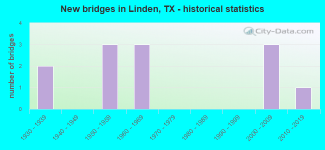
- New bridges - historical statistics
- 21930-1939
- 31950-1959
- 31960-1969
- 32000-2009
- 12010-2019

- Reconstructed bridges - Historical Statistics
- 11970-1979
- 01980-1989
- 01990-1999
- 12000-2009


- Bridge Condition - Deck
- 66.7%Good
- 33.3%Satisfactory

- Bridge Condition - Superstructure
- 66.7%Good
- 33.3%Satisfactory

- Bridge Condition - Substructure
- 66.7%Good
- 33.3%Satisfactory

- Bridge Condition - Channel
- 8.3%Very good
- 33.3%Good
- 41.7%Satisfactory
- 16.7%Fair

- Bridge Condition - Culverts
- 44.4%Good
- 44.4%Satisfactory
- 11.1%Fair
Find on map >> Show street view
Structure Number: 190340006203043, Location: 0.70 MI N OF FM 125 (Lat: 33.039319, Lng: -94.375533), Route carried "on" structure: State highway 8, Year Built: 1964, Status: Open, Structure Length: 0.82m (2.69ft), Average Daily Traffic: 1,671 (year 2020), Truck Traffic: 22%, Average Future Daily Traffic: 3,370 (year 2033), Design Load: HS 20, Features Intersected: BEACH CREEK
Minimum Vertical Clearance: 30+ m (98+ ft), Kilometerpoint: 25.225, Lanes on structure: 4, Owner: State Highway Agency, Approaching Roadway Width: 15.2m (49.9ft), Material/Design: Concrete, Design/Construction: Culvert, Number Of Spans In Main Unit: 3, Length of Maximum Span: 2.4m (7.9ft)
Condition: Channel: Satisfactory, Culverts: Good, Operating Rating: 39.9 metric tons, Method Used To Determine Operating Rating: Load Factor (LF), Inventory Rating: 23.6 metric tons, Method Used To Determine Inventory Rating: Load Factor (LF), Structural Evaluation: Equal to present minimum criteria, Waterway Adequacy: Equal to present minimum criteria, Approach Roadway Alignment: Somewhat better than minimum adequacy, Designated Inspection Frequency: Every 24 months, Inspection Date: July 2020
Find on map >> Show street view
Structure Number: 190340006204051, Location: 1.80 MI S OF SH 155 (Lat: 32.974375, Lng: -94.362144), Route carried "on" structure: US 59, Year Built: 2010, Status: Open, Structure Length: 8.53m (27.99ft), Average Daily Traffic: 3,280 (year 2020), Truck Traffic: 40%, Average Future Daily Traffic: 5,940 (year 2033), Design Load: HS 25 or greater, Features Intersected: JIM'S BAYOU
Minimum Vertical Clearance: 30+ m (98+ ft), Kilometerpoint: 46.489, Lanes on structure: 2, Owner: State Highway Agency, Approaching Roadway Width: 11.6m (38.1ft), Material/Design: Prestressed concrete, Design/Construction: Stringer/Multi-beam, Number Of Spans In Main Unit: 4, Length of Maximum Span: 21.3m (69.9ft), Curb-To-Curb Width: 11.5m (37.7ft), Out-to-Out Width: 12.2m (40.0ft)
Condition: Deck: Good, Superstructure: Good, Substructure: Good, Channel: Good, Operating Rating: 68.0 metric tons, Method Used To Determine Operating Rating: Assigned rating based on Load Factor Design (LFD) reported in metric tons, Inventory Rating: 40.8 metric tons, Method Used To Determine Inventory Rating: Assigned rating based on Load Factor Design (LFD) reported in metric tons, Structural Evaluation: Better than present minimum criteria, Deck Geometry: Equal to present minimum criteria, Waterway Adequacy: Superior to present desirable criteria, Approach Roadway Alignment: Equal to present desirable criteria, Designated Inspection Frequency: Every 24 months, Inspection Date: July 2020, Deck Structure Type: Concrete Precast Panels
Find on map >> Show street view
Structure Number: 190340006204052, Location: 1.80 MI S OF SH 155 (Lat: 32.974333, Lng: -94.362489), Route carried "on" structure: US 59, Year Built: 2008, Status: Open, Structure Length: 8.53m (27.99ft), Average Daily Traffic: 3,648 (year 2020), Truck Traffic: 40%, Average Future Daily Traffic: 5,940 (year 2033), Design Load: HS 25 or greater, Features Intersected: JIM'S BAYOU
Minimum Vertical Clearance: 30+ m (98+ ft), Kilometerpoint: 46.489, Lanes on structure: 2, Owner: State Highway Agency, Approaching Roadway Width: 11.6m (38.1ft), Material/Design: Prestressed concrete, Design/Construction: Stringer/Multi-beam, Number Of Spans In Main Unit: 4, Length of Maximum Span: 21.3m (69.9ft), Curb-To-Curb Width: 11.5m (37.7ft), Out-to-Out Width: 12.2m (40.0ft)
Condition: Deck: Good, Superstructure: Good, Substructure: Good, Channel: Good, Operating Rating: 68.0 metric tons, Method Used To Determine Operating Rating: Assigned rating based on Load Factor Design (LFD) reported in metric tons, Inventory Rating: 40.8 metric tons, Method Used To Determine Inventory Rating: Assigned rating based on Load Factor Design (LFD) reported in metric tons, Structural Evaluation: Better than present minimum criteria, Deck Geometry: Equal to present minimum criteria, Waterway Adequacy: Superior to present desirable criteria, Approach Roadway Alignment: Equal to present desirable criteria, Designated Inspection Frequency: Every 24 months, Inspection Date: July 2020, Deck Structure Type: Concrete Precast Panels
Find on map >> Show street view
Structure Number: 190340021804034, Location: 6.70 MI SW OF FM 2328 (Lat: 33.033519, Lng: -94.320753), Route carried "on" structure: US 59, Year Built: 1955, Year Reconstructed: 2000, Status: Open, Structure Length: 2.32m (7.61ft), Average Daily Traffic: 8,668 (year 2020), Truck Traffic: 40%, Average Future Daily Traffic: 16,000 (year 2033), Features Intersected: BOWMAN CREEK
Minimum Vertical Clearance: 30+ m (98+ ft), Kilometerpoint: 38.151, Lanes on structure: 5, Owner: State Highway Agency, Approaching Roadway Width: 25.6m (84.0ft), Skew: 1 degrees, Material/Design: Concrete, Design/Construction: Culvert, Number Of Spans In Main Unit: 7, Length of Maximum Span: 3.0m (9.8ft)
Condition: Channel: Very good, Culverts: Fair, Operating Rating: 39.9 metric tons, Method Used To Determine Operating Rating: Load Factor (LF), Inventory Rating: 23.6 metric tons, Method Used To Determine Inventory Rating: Load Factor (LF), Structural Evaluation: Somewhat better than minimum adequacy, Waterway Adequacy: Equal to present minimum criteria, Approach Roadway Alignment: Equal to present desirable criteria, Designated Inspection Frequency: Every 24 months, Inspection Date: July 2020
Find on map >> Show street view
Structure Number: 190340021804077, Location: 0.30 MI NE OF SH 11 (Lat: 33.016467, Lng: -94.349236), Route carried "on" structure: US 59, Year Built: 2008, Status: Open, Structure Length: 1.86m (6.10ft), Average Daily Traffic: 8,668 (year 2020), Truck Traffic: 28%, Average Future Daily Traffic: 13,860 (year 2031), Design Load: HS 20, Features Intersected: BEACH CREEK
Minimum Vertical Clearance: 30+ m (98+ ft), Kilometerpoint: 41.470, Lanes on structure: 5, Owner: State Highway Agency, Approaching Roadway Width: 25.6m (84.0ft), Skew: 4 degrees, Material/Design: Concrete, Design/Construction: Culvert, Number Of Spans In Main Unit: 4, Length of Maximum Span: 3.0m (9.8ft)
Condition: Channel: Satisfactory, Culverts: Satisfactory, Operating Rating: 44.4 metric tons, Method Used To Determine Operating Rating: Assigned rating based on Load Factor Design (LFD) reported in metric tons, Inventory Rating: 32.7 metric tons, Method Used To Determine Inventory Rating: Assigned rating based on Load Factor Design (LFD) reported in metric tons, Structural Evaluation: Equal to present minimum criteria, Waterway Adequacy: Superior to present desirable criteria, Approach Roadway Alignment: Equal to present desirable criteria, Designated Inspection Frequency: Every 48 months, Inspection Date: July 2020
Find on map >> Show street view
Structure Number: 190340021804078, Location: 0.25 MI SW OF SH 11 (Lat: 33.009925, Lng: -94.355586), Route carried "on" structure: US 59, Year Built: 2008, Status: Open, Structure Length: 0.82m (2.69ft), Average Daily Traffic: 9,215 (year 2020), Truck Traffic: 29%, Average Future Daily Traffic: 12,740 (year 2031), Design Load: HS 20, Features Intersected: BEACH CREEK TRIBUTARY
Minimum Vertical Clearance: 30+ m (98+ ft), Kilometerpoint: 41.534, Lanes on structure: 5, Owner: State Highway Agency, Approaching Roadway Width: 26.5m (86.9ft), Skew: 3 degrees, Material/Design: Concrete, Design/Construction: Culvert, Number Of Spans In Main Unit: 2, Length of Maximum Span: 3.0m (9.8ft)
Condition: Channel: Satisfactory, Culverts: Good, Operating Rating: 44.4 metric tons, Method Used To Determine Operating Rating: Assigned rating based on Load Factor Design (LFD) reported in metric tons, Inventory Rating: 32.7 metric tons, Method Used To Determine Inventory Rating: Assigned rating based on Load Factor Design (LFD) reported in metric tons, Structural Evaluation: Better than present minimum criteria, Waterway Adequacy: Superior to present desirable criteria, Approach Roadway Alignment: Equal to present desirable criteria, Designated Inspection Frequency: Every 48 months, Inspection Date: July 2020
Find on map >> Show street view
Structure Number: 190340021805023, Location: 1.05 MI W OF SH 8 (Lat: 33.007217, Lng: -94.392536), Route carried "on" structure: State highway 11, Year Built: 1934, Year Reconstructed: 1983, Status: Open, Structure Length: 1.04m (3.41ft), Average Daily Traffic: 1,804 (year 2020), Truck Traffic: 9%, Average Future Daily Traffic: 2,900 (year 2033), Design Load: H 15, Features Intersected: JIMS BAYOU
Minimum Vertical Clearance: 30+ m (98+ ft), Kilometerpoint: 24.905, Lanes on structure: 2, Owner: State Highway Agency, Approaching Roadway Width: 9.1m (29.9ft), Material/Design: Concrete, Design/Construction: Culvert, Number Of Spans In Main Unit: 4, Length of Maximum Span: 2.4m (7.9ft), Curb-To-Curb Width: 14.5m (47.6ft), Out-to-Out Width: 15.2m (49.9ft)
Condition: Channel: Fair, Culverts: Satisfactory, Operating Rating: 39.9 metric tons, Method Used To Determine Operating Rating: Load Factor (LF), Inventory Rating: 23.6 metric tons, Method Used To Determine Inventory Rating: Load Factor (LF), Structural Evaluation: Equal to present minimum criteria, Deck Geometry: Superior to present desirable criteria, Waterway Adequacy: Equal to present minimum criteria, Approach Roadway Alignment: Equal to present desirable criteria, Designated Inspection Frequency: Every 24 months, Inspection Date: July 2020, Deck Structure Type: Concrete Cast-file-Place, Wearing Surface/Protective System: Wearing Surface: Bituminous
Find on map >> Show street view
Structure Number: 190340021805024, Location: 3.45 MI W OF SH 8 (Lat: 32.998978, Lng: -94.432067), Route carried "on" structure: State highway 11, Year Built: 1934, Status: Open, Structure Length: 1.13m (3.71ft), Average Daily Traffic: 1,804 (year 2020), Truck Traffic: 9%, Average Future Daily Traffic: 2,900 (year 2033), Features Intersected: WALNUT BRANCH
Minimum Vertical Clearance: 30+ m (98+ ft), Kilometerpoint: 21.092, Lanes on structure: 2, Owner: State Highway Agency, Approaching Roadway Width: 8.5m (27.9ft), Skew: 4 degrees, Material/Design: Concrete, Design/Construction: Culvert, Number Of Spans In Main Unit: 4, Length of Maximum Span: 1.8m (5.9ft), Curb-To-Curb Width: 10.3m (33.8ft), Out-to-Out Width: 11.1m (36.4ft)
Condition: Channel: Good, Culverts: Satisfactory, Operating Rating: 32.7 metric tons, Method Used To Determine Operating Rating: Field evaluation and documented engineering judgment, Inventory Rating: 24.5 metric tons, Method Used To Determine Inventory Rating: Field evaluation and documented engineering judgment, Structural Evaluation: Equal to present minimum criteria, Deck Geometry: Somewhat better than minimum adequacy, Waterway Adequacy: Equal to present minimum criteria, Approach Roadway Alignment: Better than present minimum criteria, Designated Inspection Frequency: Every 24 months, Inspection Date: July 2020, Deck Structure Type: Concrete Cast-file-Place, Wearing Surface/Protective System: Wearing Surface: Bituminous
Find on map >> Show street view
Structure Number: 190340052003024, Location: 1.30 MI W OF US 59 (Lat: 32.995931, Lng: -94.384956), Route carried "on" structure: State highway 155, Year Built: 1950, Status: Open, Structure Length: 1.37m (4.49ft), Average Daily Traffic: 3,916 (year 2018), Truck Traffic: 20%, Average Future Daily Traffic: 4,400 (year 2033), Design Load: H 15, Features Intersected: JIMS BAYOU
Minimum Vertical Clearance: 30+ m (98+ ft), Kilometerpoint: 2.153, Lanes on structure: 2, Owner: State Highway Agency, Approaching Roadway Width: 12.2m (40.0ft), Material/Design: Concrete, Design/Construction: Culvert, Number Of Spans In Main Unit: 4, Length of Maximum Span: 3.0m (9.8ft), Curb-To-Curb Width: 12.9m (42.3ft), Out-to-Out Width: 13.6m (44.6ft)
Condition: Channel: Good, Culverts: Good, Operating Rating: 39.9 metric tons, Method Used To Determine Operating Rating: Load Factor (LF), Inventory Rating: 23.6 metric tons, Method Used To Determine Inventory Rating: Load Factor (LF), Structural Evaluation: Equal to present minimum criteria, Deck Geometry: Equal to present minimum criteria, Waterway Adequacy: Equal to present minimum criteria, Approach Roadway Alignment: Equal to present desirable criteria, Designated Inspection Frequency: Every 24 months, Inspection Date: August 2020, Deck Structure Type: Concrete Cast-file-Place, Wearing Surface/Protective System: Wearing Surface: Bituminous
Find on map >> Show street view
Structure Number: 190340054609019, Location: 1.70 MI SE OF US 59 (Lat: 32.988864, Lng: -94.337583), Route carried "on" structure: State highway 125, Year Built: 1968, Status: Open, Structure Length: 1.52m (4.99ft), Average Daily Traffic: 900 (year 2020), Truck Traffic: 14%, Average Future Daily Traffic: 1,780 (year 2033), Design Load: HS 20, Features Intersected: BEACH CREEK
Minimum Vertical Clearance: 30+ m (98+ ft), Kilometerpoint: 6.359, Lanes on structure: 2, Owner: State Highway Agency, Approaching Roadway Width: 7.0m (23.0ft), Skew: 3 degrees, Material/Design: Concrete, Design/Construction: Culvert, Number Of Spans In Main Unit: 4, Length of Maximum Span: 3.0m (9.8ft), Curb-To-Curb Width: 14.6m (47.9ft), Out-to-Out Width: 15.0m (49.2ft)
Condition: Channel: Satisfactory, Culverts: Satisfactory, Operating Rating: 39.9 metric tons, Method Used To Determine Operating Rating: Load Factor (LF), Inventory Rating: 23.6 metric tons, Method Used To Determine Inventory Rating: Load Factor (LF), Structural Evaluation: Equal to present minimum criteria, Deck Geometry: Superior to present desirable criteria, Waterway Adequacy: Equal to present minimum criteria, Approach Roadway Alignment: Equal to present desirable criteria, Designated Inspection Frequency: Every 24 months, Inspection Date: August 2020, Deck Structure Type: Concrete Cast-file-Place, Wearing Surface/Protective System: Wearing Surface: Bituminous
Find on map >> Show street view
Structure Number: 190340257601001, Location: 0.60 MI E OF US 59 (Lat: 33.007531, Lng: -94.347872), Route carried "on" structure: State highway 1841, Year Built: 1961, Status: Open, Structure Length: 1.31m (4.30ft), Average Daily Traffic: 509 (year 2020), Truck Traffic: 13%, Average Future Daily Traffic: 910 (year 2033), Features Intersected: BEACH CREEK
Minimum Vertical Clearance: 30+ m (98+ ft), Kilometerpoint: 1.054, Lanes on structure: 2, Owner: State Highway Agency, Approaching Roadway Width: 7.9m (25.9ft), Material/Design: Concrete, Design/Construction: Culvert, Number Of Spans In Main Unit: 4, Length of Maximum Span: 3.0m (9.8ft), Curb-To-Curb Width: 7.5m (24.6ft), Out-to-Out Width: 10.8m (35.4ft)
Condition: Channel: Satisfactory, Culverts: Good, Operating Rating: 39.9 metric tons, Method Used To Determine Operating Rating: Load Factor (LF), Inventory Rating: 23.6 metric tons, Method Used To Determine Inventory Rating: Load Factor (LF), Structural Evaluation: Equal to present minimum criteria, Deck Geometry: Meets minimum limits, Waterway Adequacy: Better than present minimum criteria, Approach Roadway Alignment: Equal to present desirable criteria, Designated Inspection Frequency: Every 24 months, Inspection Date: September 2020, Deck Structure Type: Concrete Cast-file-Place, Wearing Surface/Protective System: Wearing Surface: Bituminous
Find on map >> Show street view
Structure Number: 190340AA1159001, Location: 0.03 MI NW OF US 59 (Lat: 33.031058, Lng: -94.328333), Route carried "on" structure: County highway 1159, Year Built: 1950, Status: Open, Structure Length: 0.79m (2.59ft), Average Daily Traffic: 81 (year 2013), Truck Traffic: 5%, Average Future Daily Traffic: 81 (year 2033), Features Intersected: COLLEY CREEK
Minimum Vertical Clearance: 30+ m (98+ ft), Kilometerpoint: 0.048, Lanes on structure: 1, Owner: County Highway Agency, Approaching Roadway Width: 3.0m (9.8ft), Material/Design: Concrete, Design/Construction: Slab, Number Of Spans In Main Unit: 1, Length of Maximum Span: 7.6m (24.9ft), Curb-To-Curb Width: 3.8m (12.5ft), Out-to-Out Width: 4.3m (14.1ft)
Condition: Deck: Satisfactory, Superstructure: Satisfactory, Substructure: Satisfactory, Channel: Fair, Operating Rating: 32.7 metric tons, Method Used To Determine Operating Rating: Field evaluation and documented engineering judgment, Inventory Rating: 24.5 metric tons, Method Used To Determine Inventory Rating: Field evaluation and documented engineering judgment, Structural Evaluation: Equal to present minimum criteria, Deck Geometry: Meets minimum limits, Waterway Adequacy: Meets minimum limits, Approach Roadway Alignment: Equal to present desirable criteria, Designated Inspection Frequency: Every 24 months, Inspection Date: June 2020, Deck Structure Type: Concrete Cast-file-Place