Bridge Statistics for Lochbuie, Colorado (CO)
Condition, Traffic, Stress, Structural Evaluation, Project Costs
- National Bridge Inventory (NBI) Statistics
- 19Number of bridges
- 174ft / 53.5mTotal length
- $269,000Total costs
- 163,302Total average daily traffic
- 25,607Total average daily truck traffic
- National Bridge Inventory (NBI) Registered Bridges for Lochbuie
- No street view available for this location
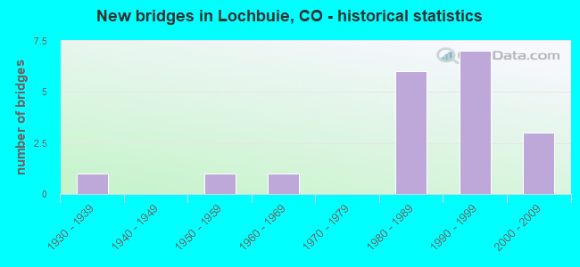
- New bridges - historical statistics
- 11930-1939
- 11950-1959
- 11960-1969
- 61980-1989
- 71990-1999
- 32000-2009

- Reconstructed bridges - Historical Statistics
- 11960-1969
- 11970-1979


- Bridge Condition - Deck
- 6.7%Very good
- 26.7%Good
- 26.7%Satisfactory
- 20.0%Fair
- 20.0%Poor

- Bridge Condition - Superstructure
- 6.7%Good
- 60.0%Satisfactory
- 26.7%Fair
- 6.7%Poor

- Bridge Condition - Substructure
- 33.3%Good
- 60.0%Satisfactory
- 6.7%Fair

- Bridge Condition - Channel
- 50.0%Very good
- 35.7%Good
- 14.3%Satisfactory
Find on map >> Show street view
Structure Number: ADA152-19.1N122, Location: 0.2 MILE E OF HARVEST RD (Lat: 39.972461, Lng: -104.695342), Route carried "on" structure: County highway , Year Built: 1989, Status: Open, Structure Length: 1.58m (5.18ft), Average Daily Traffic: 5,901 (year 2021), Truck Traffic: 4%, Average Future Daily Traffic: 7,672 (year 2041), Features Intersected: HUDSON CANAL, Facility Carried by Structure: 152ND AVENUE
Minimum Vertical Clearance: 30+ m (98+ ft), Kilometerpoint: 4.651, Lanes on structure: 2, Owner: County Highway Agency, Approaching Roadway Width: 8.5m (27.9ft), Material/Design: Prestressed concrete, Design/Construction: Box Beam or Girders - Single/Spread, Number Of Spans In Main Unit: 1, Length of Maximum Span: 14.3m (46.9ft), Curb-To-Curb Width: 11.0m (36.1ft), Out-to-Out Width: 11.7m (38.4ft)
Condition: Deck: Good, Superstructure: Fair, Substructure: Good, Channel: Good, Operating Rating: 54.7 metric tons, Method Used To Determine Operating Rating: Load Factor (LF), Inventory Rating: 32.8 metric tons, Method Used To Determine Inventory Rating: Load Factor (LF), Structural Evaluation: Somewhat better than minimum adequacy, Deck Geometry: Meets minimum limits, Waterway Adequacy: Equal to present desirable criteria, Approach Roadway Alignment: Equal to present desirable criteria, Designated Inspection Frequency: Every 24 months, Inspection Date: December 2021, Deck Structure Type: Concrete Cast-file-Place, Wearing Surface/Protective System: Wearing Surface: Bituminous, Membrane: Built-up, Deck Protection: Epoxy Coated Reinforcing
Find on map >> Show street view
Structure Number: ADA160-019.3119, Location: 0.2 MILE E OF HARVEST RD (Lat: 39.986975, Lng: -104.692214), Route carried "on" structure: County highway , Year Built: 1997, Status: Open, Structure Length: 1.55m (5.09ft), Average Daily Traffic: 965 (year 2021), Truck Traffic: 5%, Average Future Daily Traffic: 1,254 (year 2041), Features Intersected: NERES CANAL, Facility Carried by Structure: 160TH AVENUE
Minimum Vertical Clearance: 30+ m (98+ ft), Kilometerpoint: 4.023, Lanes on structure: 2, Owner: County Highway Agency, Approaching Roadway Width: 7.6m (24.9ft), Skew: 3 degrees, Material/Design: Steel, Design/Construction: Stringer/Multi-beam, Number Of Spans In Main Unit: 1, Length of Maximum Span: 14.4m (47.2ft), Curb-To-Curb Width: 8.7m (28.5ft), Out-to-Out Width: 8.9m (29.2ft)
Condition: Deck: Good, Superstructure: Satisfactory, Substructure: Good, Channel: Very good, Operating Rating: 46.3 metric tons, Method Used To Determine Operating Rating: Load Factor (LF), Inventory Rating: 27.7 metric tons, Method Used To Determine Inventory Rating: Load Factor (LF), Structural Evaluation: Equal to present minimum criteria, Deck Geometry: Somewhat better than minimum adequacy, Waterway Adequacy: Equal to present desirable criteria, Approach Roadway Alignment: Equal to present desirable criteria, Designated Inspection Frequency: Every 24 months, Inspection Date: December 2021, Deck Structure Type: Corrugated Steel, Wearing Surface/Protective System: Wearing Surface: Bituminous
Find on map >> Show street view
Structure Number: ADA160-19.7N12, Location: 0.6 MI EAST OF HARVEST RD (Lat: 39.986978, Lng: -104.686347), Route carried "on" structure: County highway , Year Built: 1997, Status: Open, Structure Length: 1.84m (6.04ft), Average Daily Traffic: 779 (year 2021), Truck Traffic: 5%, Average Future Daily Traffic: 1,012 (year 2041), Features Intersected: HUDSON CANAL, Facility Carried by Structure: 160TH AVENUE
Minimum Vertical Clearance: 30+ m (98+ ft), Kilometerpoint: 4.529, Lanes on structure: 2, Owner: County Highway Agency, Approaching Roadway Width: 7.6m (24.9ft), Material/Design: Steel, Design/Construction: Stringer/Multi-beam, Number Of Spans In Main Unit: 1, Length of Maximum Span: 17.7m (58.1ft), Curb-To-Curb Width: 7.4m (24.3ft), Out-to-Out Width: 8.6m (28.2ft)
Condition: Deck: Satisfactory, Superstructure: Satisfactory, Substructure: Satisfactory, Channel: Satisfactory, Operating Rating: 31.3 metric tons, Method Used To Determine Operating Rating: Load Factor (LF), Inventory Rating: 18.7 metric tons, Method Used To Determine Inventory Rating: Load Factor (LF), Structural Evaluation: Somewhat better than minimum adequacy, Deck Geometry: Meets minimum limits, Waterway Adequacy: Equal to present desirable criteria, Approach Roadway Alignment: Equal to present desirable criteria, Designated Inspection Frequency: Every 24 months, Inspection Date: December 2021, Deck Structure Type: Corrugated Steel, Wearing Surface/Protective System: Wearing Surface: Bituminous
Find on map >> Show street view
Structure Number: ADA19N-150.0123, Location: 0.2 MILE S OF 152ND AVE (Lat: 39.968986, Lng: -104.697372), Route carried "on" structure: County highway , Year Built: 1993, Status: Open, Structure Length: 1.27m (4.17ft), Average Daily Traffic: 325 (year 2021), Truck Traffic: 5%, Average Future Daily Traffic: 422 (year 2041), Features Intersected: HUDSON CANAL, Facility Carried by Structure: HARVEST ROAD
Minimum Vertical Clearance: 30+ m (98+ ft), Kilometerpoint: 4.405, Lanes on structure: 2, Owner: County Highway Agency, Approaching Roadway Width: 7.3m (24.0ft), Skew: 3 degrees, Material/Design: Steel, Design/Construction: Stringer/Multi-beam, Number Of Spans In Main Unit: 1, Length of Maximum Span: 11.7m (38.4ft), Curb-To-Curb Width: 7.3m (24.0ft), Out-to-Out Width: 7.4m (24.3ft)
Condition: Deck: Very good, Superstructure: Satisfactory, Substructure: Fair, Channel: Very good, Operating Rating: 52.3 metric tons, Method Used To Determine Operating Rating: Load Factor (LF), Inventory Rating: 31.4 metric tons, Method Used To Determine Inventory Rating: Load Factor (LF), Structural Evaluation: Somewhat better than minimum adequacy, Deck Geometry: Somewhat better than minimum adequacy, Waterway Adequacy: Equal to present desirable criteria, Approach Roadway Alignment: Equal to present desirable criteria, Designated Inspection Frequency: Every 24 months, Inspection Date: December 2021, Deck Structure Type: Corrugated Steel, Wearing Surface/Protective System: Wearing Surface: Bituminous, Membrane: Other
Find on map >> Show street view
Structure Number: ADA19N-154.4121, Location: 0.3 MILE N OF 152ND AVE (Lat: 39.977022, Lng: -104.697283), Route carried "on" structure: County highway , Year Built: 1990, Status: Open, Structure Length: 1.68m (5.51ft), Average Daily Traffic: 889 (year 2021), Truck Traffic: 4%, Average Future Daily Traffic: 1,155 (year 2041), Features Intersected: NERES CANAL, Facility Carried by Structure: HARVEST ROAD
Minimum Vertical Clearance: 30+ m (98+ ft), Kilometerpoint: 5.354, Lanes on structure: 2, Owner: County Highway Agency, Approaching Roadway Width: 9.1m (29.9ft), Skew: 4 degrees, Material/Design: Prestressed concrete, Design/Construction: Box Beam or Girders - Single/Spread, Number Of Spans In Main Unit: 1, Length of Maximum Span: 14.4m (47.2ft), Curb-To-Curb Width: 11.0m (36.1ft), Out-to-Out Width: 11.7m (38.4ft)
Condition: Deck: Good, Superstructure: Fair, Substructure: Satisfactory, Channel: Very good, Operating Rating: 53.1 metric tons, Method Used To Determine Operating Rating: Load Factor (LF), Inventory Rating: 31.8 metric tons, Method Used To Determine Inventory Rating: Load Factor (LF), Structural Evaluation: Somewhat better than minimum adequacy, Deck Geometry: Better than present minimum criteria, Waterway Adequacy: Equal to present desirable criteria, Approach Roadway Alignment: Equal to present desirable criteria, Designated Inspection Frequency: Every 24 months, Inspection Date: December 2021, Deck Structure Type: Concrete Cast-file-Place, Wearing Surface/Protective System: Wearing Surface: Bituminous, Membrane: Built-up, Deck Protection: Epoxy Coated Reinforcing
Find on map >> Show street view
Structure Number: D-18-BN, Location: 2.8 MILES NE OF JCT SH 7 (Lat: 40.015036, Lng: -104.699778), Route carried "on" structure: County highway , Year Built: 1981, Status: Open, Structure Length: 18.57m (60.93ft), Average Daily Traffic: 25,000 (year 2018), Truck Traffic: 10%, Average Future Daily Traffic: 356 (year 2025), Design Load: HS 20+Mod, Features Intersected: I 76 ML, BNSF RR, Facility Carried by Structure: COUNTY ROAD 4
Minimum Vertical Clearance: 30+ m (98+ ft), Kilometerpoint: 4.540, Lanes on structure: 2, Lanes under structure: 4, Owner: State Highway Agency, Approaching Roadway Width: 9.8m (32.2ft), Skew: 3 degrees, Material/Design: Steel continuous, Design/Construction: Stringer/Multi-beam, Number Of Spans In Main Unit: 5, Length of Maximum Span: 45.9m (150.6ft), Curb-To-Curb Width: 10.4m (34.1ft), Out-to-Out Width: 11.1m (36.4ft)
Condition: Deck: Satisfactory, Superstructure: Poor, Substructure: Satisfactory, Operating Rating: 31.2 metric tons, Method Used To Determine Operating Rating: Load Factor (LF), Inventory Rating: 18.7 metric tons, Method Used To Determine Inventory Rating: Load Factor (LF), Structural Evaluation: Meets minimum limits, Deck Geometry: Meets minimum limits, Underclear: Equal to present minimum criteria, Approach Roadway Alignment: Better than present minimum criteria, Designated Inspection Frequency: Every 24 months, Inspection Date: November 2020, Deck Structure Type: Concrete Cast-file-Place, Wearing Surface/Protective System: Wearing Surface: Bituminous, Membrane: Preformed Fabric
Find on map >> Show street view
Structure Number: D-18-H, Location: 4 MI S OF JCT SH 52 (Lat: 40.025375, Lng: -104.688767), Route carried "on" structure: Interstate 76A, Year Built: 1935, Year Reconstructed: 1969, Status: Open, Structure Length: 0.64m (2.10ft), Average Daily Traffic: 23,000 (year 2020), Truck Traffic: 18%, Average Future Daily Traffic: 37,260 (year 2040), Design Load: H 15, Features Intersected: DRAW, Facility Carried by Structure: I 76 ML
Minimum Vertical Clearance: 30+ m (98+ ft), Kilometerpoint: 44.040, Lanes on structure: 6, Base Highway Network: Yes, Owner: State Highway Agency, Approaching Roadway Width: 32.3m (106.0ft), Skew: 20 degrees, Material/Design: Concrete, Design/Construction: Culvert, Number Of Spans In Main Unit: 2, Length of Maximum Span: 3.0m (9.8ft), Out-to-Out Width: 72.2m (236.9ft)
Condition: Channel: Very good, Culverts: Satisfactory, Operating Rating: 36.3 metric tons, Method Used To Determine Operating Rating: Allowable Stress (AS), Inventory Rating: 32.7 metric tons, Method Used To Determine Inventory Rating: Allowable Stress (AS), Structural Evaluation: Equal to present minimum criteria, Waterway Adequacy: Equal to present desirable criteria, Approach Roadway Alignment: Equal to present desirable criteria, Length Of Structure Improvement: 0.68m (2.23ft), Designated Inspection Frequency: Every 24 months, Inspection Date: March 2021, Bridge Improvement Cost: $179,000, Roadway Improvement Cost: $18,000, Total Project Cost: $269,000
Find on map >> Show street view
Structure Number: D-18-K, Location: 6 MI SW OF JCT SH 52 (Lat: 40.003942, Lng: -104.710414), Route carried "on" structure: Interstate 76A, Year Built: 1954, Year Reconstructed: 1981, Status: Open, Structure Length: 1.34m (4.40ft), Average Daily Traffic: 23,000 (year 2020), Truck Traffic: 18%, Average Future Daily Traffic: 37,260 (year 2040), Design Load: HS 20, Features Intersected: SEEP CANAL, Facility Carried by Structure: I 76 ML
Minimum Vertical Clearance: 30+ m (98+ ft), Kilometerpoint: 41.024, Lanes on structure: 7, Base Highway Network: Yes, Owner: State Highway Agency, Approaching Roadway Width: 35.7m (117.1ft), Skew: 10 degrees, Material/Design: Concrete, Design/Construction: Culvert, Number Of Spans In Main Unit: 3, Length of Maximum Span: 5.0m (16.4ft), Out-to-Out Width: 68.3m (224.1ft)
Condition: Channel: Very good, Culverts: Satisfactory, Operating Rating: 36.3 metric tons, Method Used To Determine Operating Rating: Field evaluation and documented engineering judgment, Inventory Rating: 32.7 metric tons, Method Used To Determine Inventory Rating: Field evaluation and documented engineering judgment, Structural Evaluation: Equal to present minimum criteria, Waterway Adequacy: Equal to present desirable criteria, Approach Roadway Alignment: Equal to present desirable criteria, Designated Inspection Frequency: Every 24 months, Inspection Date: March 2021
Find on map >> Show street view
Structure Number: E-18-AM, Location: LOCHBUIE INTERCHANGE (Lat: 40.000464, Lng: -104.715517), Route carried "on" structure: County highway , Year Built: 1981, Status: Open, Structure Length: 9.32m (30.58ft), Average Daily Traffic: 8,326 (year 2021), Average Future Daily Traffic: 10,824 (year 2041), Design Load: HS 20+Mod, Features Intersected: I 76 ML, Facility Carried by Structure: COUNTY ROAD
Minimum Vertical Clearance: 30+ m (98+ ft), Kilometerpoint: 2.009, Lanes on structure: 2, Lanes under structure: 4, Owner: State Highway Agency, Approaching Roadway Width: 13.4m (44.0ft), Skew: 4 degrees, Material/Design: Steel continuous, Design/Construction: Stringer/Multi-beam, Number Of Spans In Main Unit: 2, Length of Maximum Span: 45.7m (149.9ft), Curb-To-Curb Width: 13.4m (44.0ft), Out-to-Out Width: 14.2m (46.6ft)
Condition: Deck: Satisfactory, Superstructure: Satisfactory, Substructure: Satisfactory, Operating Rating: 64.8 metric tons, Method Used To Determine Operating Rating: Load Factor (LF), Inventory Rating: 38.7 metric tons, Method Used To Determine Inventory Rating: Load Factor (LF), Structural Evaluation: Equal to present minimum criteria, Deck Geometry: Equal to present minimum criteria, Underclear: Better than present minimum criteria, Approach Roadway Alignment: Equal to present desirable criteria, Designated Inspection Frequency: Every 24 months, Inspection Date: Febuary 2021, Deck Structure Type: Concrete Cast-file-Place, Wearing Surface/Protective System: Wearing Surface: Bituminous, Membrane: Preformed Fabric
Find on map >> Show street view
Structure Number: E-18-AN, Location: E. SIDE LOCHBUIE INT. (Lat: 40.000458, Lng: -104.712278), Route carried "on" structure: ServiceInterstate 76A, Year Built: 1981, Status: Open, Structure Length: 6.01m (19.72ft), Average Daily Traffic: 23,000 (year 2020), Truck Traffic: 18%, Average Future Daily Traffic: 37,260 (year 2040), Design Load: HS 20+Mod, Features Intersected: BNSF RR AR, Facility Carried by Structure: I76 AR TO CO RD 2
Minimum Vertical Clearance: 30+ m (98+ ft), Kilometerpoint: 2.317, Lanes on structure: 2, Owner: State Highway Agency, Approaching Roadway Width: 13.4m (44.0ft), Skew: 3 degrees, Material/Design: Steel continuous, Design/Construction: Stringer/Multi-beam, Number Of Spans In Main Unit: 3, Length of Maximum Span: 23.2m (76.1ft), Curb-To-Curb Width: 13.4m (44.0ft), Out-to-Out Width: 14.2m (46.6ft)
Condition: Deck: Good, Superstructure: Good, Substructure: Good, Operating Rating: 44.2 metric tons, Method Used To Determine Operating Rating: Load Factor (LF), Inventory Rating: 26.5 metric tons, Method Used To Determine Inventory Rating: Load Factor (LF), Structural Evaluation: Equal to present minimum criteria, Deck Geometry: Equal to present minimum criteria, Underclear: Equal to present minimum criteria, Approach Roadway Alignment: Equal to present desirable criteria, Designated Inspection Frequency: Every 24 months, Inspection Date: Febuary 2021, Deck Structure Type: Concrete Cast-file-Place, Wearing Surface/Protective System: Wearing Surface: Bituminous, Membrane: Preformed Fabric
Find on map >> Show street view
Structure Number: LB004.0_037.0A, Location: 0.5 MI E of Co Rd 37 (Lat: 40.015000, Lng: -104.705278), Route carried "on" structure: City street , Year Built: 1996, Status: Posted for load-capacity, Structure Length: 1.91m (6.27ft), Average Daily Traffic: 1,590 (year 2020), Truck Traffic: 34%, Average Future Daily Traffic: 2,258 (year 2040), Design Load: HS 20, Features Intersected: Beebe Seep Canal, Facility Carried by Structure: County Road 4
Minimum Vertical Clearance: 30+ m (98+ ft), Kilometerpoint: 4.113, Lanes on structure: 2, Owner: Town or Township Highway Agency, Approaching Roadway Width: 7.3m (24.0ft), Skew: 1 degrees, Material/Design: Steel, Design/Construction: Stringer/Multi-beam, Number Of Spans In Main Unit: 1, Length of Maximum Span: 18.5m (60.7ft), Curb-To-Curb Width: 9.4m (30.8ft), Out-to-Out Width: 9.8m (32.2ft)
Condition: Deck: Poor, Superstructure: Fair, Substructure: Satisfactory, Channel: Good, Operating Rating: 44.4 metric tons, Method Used To Determine Operating Rating: Load Factor (LF), Inventory Rating: 26.6 metric tons, Method Used To Determine Inventory Rating: Load Factor (LF), Structural Evaluation: Somewhat better than minimum adequacy, Deck Geometry: Somewhat better than minimum adequacy, Waterway Adequacy: Equal to present desirable criteria, Approach Roadway Alignment: Equal to present desirable criteria, Designated Inspection Frequency: Every 24 months, Inspection Date: Febuary 2022, Deck Structure Type: Corrugated Steel, Wearing Surface/Protective System: Wearing Surface: Bituminous
Find on map >> Show street view
Structure Number: WEL002.0-039.0A, Location: 0.9 Mi E of CR 39 (Lat: 40.000542, Lng: -104.683014), Route carried "on" structure: County highway , Year Built: 2007, Status: Open, Structure Length: 0.84m (2.76ft), Average Daily Traffic: 3,892 (year 2020), Truck Traffic: 20%, Average Future Daily Traffic: 5,527 (year 2040), Design Load: HS 20, Features Intersected: Neres Canal, Facility Carried by Structure: County Road 2
Minimum Vertical Clearance: 30+ m (98+ ft), Kilometerpoint: 2.013, Lanes on structure: 2, Owner: County Highway Agency, Approaching Roadway Width: 9.8m (32.2ft), Material/Design: Steel, Design/Construction: Stringer/Multi-beam, Number Of Spans In Main Unit: 1, Length of Maximum Span: 7.4m (24.3ft), Curb-To-Curb Width: 11.9m (39.0ft), Out-to-Out Width: 12.2m (40.0ft)
Condition: Deck: Fair, Superstructure: Satisfactory, Substructure: Satisfactory, Channel: Good, Operating Rating: 66.2 metric tons, Method Used To Determine Operating Rating: Load Factor (LF), Inventory Rating: 39.6 metric tons, Method Used To Determine Inventory Rating: Load Factor (LF), Structural Evaluation: Equal to present minimum criteria, Deck Geometry: Somewhat better than minimum adequacy, Waterway Adequacy: Equal to present desirable criteria, Approach Roadway Alignment: Equal to present desirable criteria, Designated Inspection Frequency: Every 24 months, Inspection Date: Febuary 2022, Deck Structure Type: Corrugated Steel, Wearing Surface/Protective System: Wearing Surface: Bituminous
Find on map >> Show street view
Structure Number: WEL002.0_041.0A, Location: 1.2 Mi E of CR 39 (Lat: 40.000494, Lng: -104.673578), Route carried "on" structure: County highway , Year Built: 2007, Status: Open, Structure Length: 1.50m (4.92ft), Average Daily Traffic: 3,849 (year 2020), Truck Traffic: 26%, Average Future Daily Traffic: 5,466 (year 2040), Design Load: HS 20, Features Intersected: Denver Hudson Canal, Facility Carried by Structure: County Road 2
Minimum Vertical Clearance: 30+ m (98+ ft), Kilometerpoint: 2.816, Lanes on structure: 2, Owner: County Highway Agency, Approaching Roadway Width: 9.8m (32.2ft), Skew: 3 degrees, Material/Design: Steel, Design/Construction: Stringer/Multi-beam, Number Of Spans In Main Unit: 1, Length of Maximum Span: 14.2m (46.6ft), Curb-To-Curb Width: 11.8m (38.7ft), Out-to-Out Width: 12.2m (40.0ft)
Condition: Deck: Fair, Superstructure: Satisfactory, Substructure: Satisfactory, Channel: Very good, Operating Rating: 76.5 metric tons, Method Used To Determine Operating Rating: Load Factor (LF), Inventory Rating: 45.8 metric tons, Method Used To Determine Inventory Rating: Load Factor (LF), Structural Evaluation: Equal to present minimum criteria, Deck Geometry: Somewhat better than minimum adequacy, Waterway Adequacy: Equal to present desirable criteria, Approach Roadway Alignment: Equal to present desirable criteria, Designated Inspection Frequency: Every 24 months, Inspection Date: Febuary 2022, Deck Structure Type: Corrugated Steel, Wearing Surface/Protective System: Wearing Surface: Bituminous
Find on map >> Show street view
Structure Number: WEL004.0-043.0A, Location: 1.1 Mi E of Co Rd 41 (Lat: 40.015156, Lng: -104.655461), Route carried "on" structure: County highway , Year Built: 1965, Status: Open, Structure Length: 1.20m (3.94ft), Average Daily Traffic: 939 (year 2020), Truck Traffic: 32%, Average Future Daily Traffic: 1,333 (year 2040), Design Load: HS 20, Features Intersected: Denver Hudson Canal, Facility Carried by Structure: County Road 4
Minimum Vertical Clearance: 30+ m (98+ ft), Kilometerpoint: 3.304, Lanes on structure: 2, Owner: County Highway Agency, Approaching Roadway Width: 7.6m (24.9ft), Skew: 4 degrees, Material/Design: Steel, Design/Construction: Stringer/Multi-beam, Number Of Spans In Main Unit: 1, Length of Maximum Span: 11.3m (37.1ft), Curb-To-Curb Width: 9.4m (30.8ft), Out-to-Out Width: 9.6m (31.5ft)
Condition: Deck: Satisfactory, Superstructure: Satisfactory, Substructure: Satisfactory, Channel: Satisfactory, Operating Rating: 59.1 metric tons, Method Used To Determine Operating Rating: Load Factor (LF), Inventory Rating: 35.4 metric tons, Method Used To Determine Inventory Rating: Load Factor (LF), Structural Evaluation: Equal to present minimum criteria, Deck Geometry: Equal to present minimum criteria, Waterway Adequacy: Equal to present desirable criteria, Approach Roadway Alignment: Equal to present desirable criteria, Designated Inspection Frequency: Every 24 months, Inspection Date: Febuary 2022, Deck Structure Type: Corrugated Steel, Wearing Surface/Protective System: Wearing Surface: Bituminous
Find on map >> Show street view
Structure Number: WEL004.0_039.0A, Location: 0.5 Mi E of Hwy I-76 (Lat: 40.015056, Lng: -104.680111), Route carried "on" structure: County highway , Year Built: 1994, Status: Open, Structure Length: 1.23m (4.04ft), Average Daily Traffic: 1,178 (year 2020), Truck Traffic: 36%, Average Future Daily Traffic: 1,673 (year 2040), Design Load: HS 20, Features Intersected: Neres Canal, Facility Carried by Structure: County Road 4
Minimum Vertical Clearance: 30+ m (98+ ft), Kilometerpoint: 1.152, Lanes on structure: 2, Owner: County Highway Agency, Approaching Roadway Width: 8.8m (28.9ft), Material/Design: Steel, Design/Construction: Stringer/Multi-beam, Number Of Spans In Main Unit: 1, Length of Maximum Span: 11.1m (36.4ft), Curb-To-Curb Width: 9.5m (31.2ft), Out-to-Out Width: 9.8m (32.2ft)
Condition: Deck: Poor, Superstructure: Fair, Substructure: Good, Channel: Good, Operating Rating: 31.6 metric tons, Method Used To Determine Operating Rating: Load Factor (LF), Inventory Rating: 18.9 metric tons, Method Used To Determine Inventory Rating: Load Factor (LF), Structural Evaluation: Somewhat better than minimum adequacy, Deck Geometry: Somewhat better than minimum adequacy, Waterway Adequacy: Equal to present desirable criteria, Approach Roadway Alignment: Equal to present desirable criteria, Designated Inspection Frequency: Every 24 months, Inspection Date: Febuary 2022, Deck Structure Type: Corrugated Steel, Wearing Surface/Protective System: Wearing Surface: Bituminous
Find on map >> Show street view
Structure Number: WEL004.0_041.0A, Location: 0.1 Mi E of Co Rd 41 (Lat: 40.015056, Lng: -104.676389), Route carried "on" structure: County highway , Year Built: 1996, Status: Open, Structure Length: 1.21m (3.97ft), Average Daily Traffic: 961 (year 2020), Truck Traffic: 37%, Average Future Daily Traffic: 1,365 (year 2040), Design Load: HS 20, Features Intersected: Denver Hudson Canal, Facility Carried by Structure: County Road 4
Minimum Vertical Clearance: 30+ m (98+ ft), Kilometerpoint: 1.495, Lanes on structure: 2, Owner: County Highway Agency, Approaching Roadway Width: 8.8m (28.9ft), Skew: 2 degrees, Material/Design: Steel, Design/Construction: Stringer/Multi-beam, Number Of Spans In Main Unit: 1, Length of Maximum Span: 11.4m (37.4ft), Curb-To-Curb Width: 9.5m (31.2ft), Out-to-Out Width: 9.8m (32.2ft)
Condition: Deck: Poor, Superstructure: Satisfactory, Substructure: Satisfactory, Channel: Good, Operating Rating: 46.3 metric tons, Method Used To Determine Operating Rating: Load Factor (LF), Inventory Rating: 27.8 metric tons, Method Used To Determine Inventory Rating: Load Factor (LF), Structural Evaluation: Equal to present minimum criteria, Deck Geometry: Equal to present minimum criteria, Waterway Adequacy: Equal to present minimum criteria, Approach Roadway Alignment: Equal to present desirable criteria, Designated Inspection Frequency: Every 24 months, Inspection Date: Febuary 2022, Deck Structure Type: Corrugated Steel, Wearing Surface/Protective System: Wearing Surface: Bituminous
Find on map >> Show street view
Structure Number: WEL004.0_041.0B, Location: 0.3 Mi E of Co Rd 41 (Lat: 40.015139, Lng: -104.670694), Route carried "on" structure: County highway , Year Built: 2003, Status: Open, Structure Length: 1.79m (5.87ft), Average Daily Traffic: 961 (year 2020), Truck Traffic: 37%, Average Future Daily Traffic: 1,365 (year 2040), Design Load: HS 20, Features Intersected: Denver Hudson Canal, Facility Carried by Structure: County Road 4
Minimum Vertical Clearance: 30+ m (98+ ft), Kilometerpoint: 1.905, Lanes on structure: 2, Owner: County Highway Agency, Approaching Roadway Width: 9.1m (29.9ft), Skew: 4 degrees, Material/Design: Steel, Design/Construction: Stringer/Multi-beam, Number Of Spans In Main Unit: 1, Length of Maximum Span: 16.9m (55.4ft), Curb-To-Curb Width: 12.1m (39.7ft), Out-to-Out Width: 12.3m (40.4ft)
Condition: Deck: Fair, Superstructure: Satisfactory, Substructure: Good, Channel: Very good, Operating Rating: 55.2 metric tons, Method Used To Determine Operating Rating: Load Factor (LF), Inventory Rating: 33.0 metric tons, Method Used To Determine Inventory Rating: Load Factor (LF), Structural Evaluation: Equal to present minimum criteria, Deck Geometry: Better than present minimum criteria, Waterway Adequacy: Equal to present desirable criteria, Approach Roadway Alignment: Equal to present desirable criteria, Designated Inspection Frequency: Every 24 months, Inspection Date: Febuary 2022, Deck Structure Type: Corrugated Steel, Wearing Surface/Protective System: Wearing Surface: Bituminous
Find on map >> Show street view
Structure Number: D-18-BN, Location: 2.8 MILES NE OF JCT SH 7 (Lat: 40.015036, Lng: -104.699778), Route carried "under" structure: Interstate 76A, Year Built: 1981, Structure Length: 0. m, Average Daily Traffic: 25,000 (year 2018), Truck Traffic: 18%, Features Intersected: I 76 ML, BNSF RR, Facility Carried by Structure: COUNTY ROAD 4
Minimum Vertical Clearance: 6.73m (22.08ft), Kilometerpoint: 4.540, Lanes on structure: 2, Lanes under structure: 4, Material/Design: Steel continuous, Design/Construction: Stringer/Multi-beam, Length of Maximum Span: 45.9m (150.6ft)
Find on map >> Show street view
Structure Number: E-18-AM, Location: LOCHBUIE INTERCHANGE (Lat: 40.000464, Lng: -104.715517), Route carried "under" structure: Interstate 76A, Year Built: 1981, Structure Length: 0. m, Average Daily Traffic: 13,747 (year 2016), Truck Traffic: 15%, Features Intersected: I 76 ML, Facility Carried by Structure: COUNTY ROAD
Minimum Vertical Clearance: 5.18m (16.99ft), Kilometerpoint: 2.010, Lanes on structure: 2, Lanes under structure: 4, Material/Design: Steel continuous, Design/Construction: Stringer/Multi-beam, Length of Maximum Span: 45.7m (149.9ft)