Bridge Statistics for Lockeford, California (CA)
Condition, Traffic, Stress, Structural Evaluation, Project Costs
- National Bridge Inventory (NBI) Statistics
- 18Number of bridges
- 174ft / 53.0mTotal length
- 35,977Total average daily traffic
- 4,069Total average daily truck traffic
- 53,040Total future (year 2038) average daily traffic
- National Bridge Inventory (NBI) Registered Bridges for Lockeford
- No street view available for this location
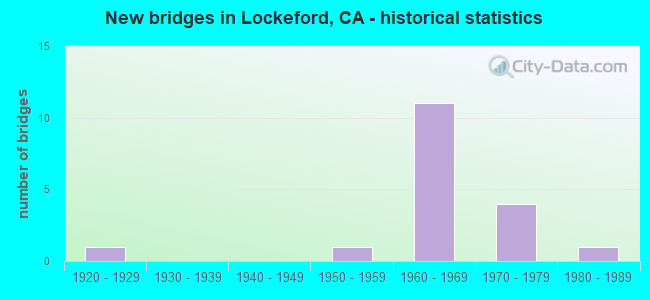
- New bridges - historical statistics
- 11920-1929
- 11950-1959
- 111960-1969
- 41970-1979
- 11980-1989

- Reconstructed bridges - Historical Statistics
- 11930-1939
- 01940-1949
- 01950-1959
- 01960-1969
- 01970-1979
- 01980-1989
- 11990-1999


- Bridge Condition - Deck
- 66.7%Good
- 33.3%Fair

- Bridge Condition - Superstructure
- 66.7%Good
- 33.3%Fair

- Bridge Condition - Substructure
- 83.3%Good
- 16.7%Fair

- Bridge Condition - Channel
- 16.7%Very good
- 38.9%Good
- 38.9%Satisfactory
- 5.6%Poor
Find on map >> Show street view
Structure Number: 29 0062, Location: 10-SJ-088-8.91 (Lat: 38.091828, Lng: -121.181264), Route carried "on" structure: State highway 88, Year Built: 1964, Status: Open, Structure Length: 4.28m (14.04ft), Average Daily Traffic: 8,850 (year 2009), Average Future Daily Traffic: 13,321 (year 2039), Design Load: H 20, Features Intersected: BEAR CREEK
Minimum Vertical Clearance: 30+ m (98+ ft), Kilometerpoint: 8.910, Lanes on structure: 2, Base Highway Network: Yes (, Subroute: 1), Owner: State Highway Agency, Approaching Roadway Width: 9.8m (32.2ft), Skew: 2 degrees, Material/Design: Concrete continuous, Design/Construction: Slab, Number Of Spans In Main Unit: 4, Length of Maximum Span: 12.2m (40.0ft), Curb-To-Curb Width: 9.8m (32.2ft), Out-to-Out Width: 10.4m (34.1ft)
Condition: Deck: Fair, Superstructure: Fair, Substructure: Good, Channel: Satisfactory, Operating Rating: 45.4 metric tons, Method Used To Determine Operating Rating: Load Factor (LF), Inventory Rating: 27.2 metric tons, Method Used To Determine Inventory Rating: Load Factor (LF), Structural Evaluation: Somewhat better than minimum adequacy, Deck Geometry: Meets minimum limits, Waterway Adequacy: Better than present minimum criteria, Approach Roadway Alignment: Equal to present desirable criteria, Designated Inspection Frequency: Every 24 months, Inspection Date: March 2021, Deck Structure Type: Concrete Cast-file-Place
Find on map >> Show street view
Structure Number: 29 0063, Location: 10-SJ-088-9.34 (Lat: 38.097831, Lng: -121.179408), Route carried "on" structure: State highway 88, Year Built: 1925, Year Reconstructed: 1944, Status: Open, Structure Length: 2.08m (6.82ft), Average Daily Traffic: 8,850 (year 2009), Average Future Daily Traffic: 13,321 (year 2039), Design Load: H 20, Features Intersected: BEAR CREEK OVERFLOW
Minimum Vertical Clearance: 30+ m (98+ ft), Kilometerpoint: 9.340, Lanes on structure: 2, Base Highway Network: Yes (, Subroute: 1), Owner: State Highway Agency, Approaching Roadway Width: 7.3m (24.0ft), Material/Design: Concrete continuous, Design/Construction: Slab, Number Of Spans In Main Unit: 3, Length of Maximum Span: 6.7m (22.0ft), Curb or Sidewalk Widths: Left: 0.4m (1.3ft), Right: 0.4m (1.3ft), Curb-To-Curb Width: 7.3m (24.0ft), Out-to-Out Width: 8.3m (27.2ft)
Condition: Deck: Good, Superstructure: Good, Substructure: Good, Channel: Satisfactory, Operating Rating: 46.0 metric tons, Method Used To Determine Operating Rating: Load Factor (LF), Inventory Rating: 27.5 metric tons, Method Used To Determine Inventory Rating: Load Factor (LF), Structural Evaluation: Equal to present minimum criteria, Deck Geometry: High priority of replacement, Waterway Adequacy: Equal to present minimum criteria, Approach Roadway Alignment: Equal to present desirable criteria, Designated Inspection Frequency: Every 24 months, Inspection Date: March 2021, Deck Structure Type: Concrete Cast-file-Place, Wearing Surface/Protective System: Wearing Surface: Bituminous
Find on map >> Show street view
Structure Number: 29C0035, Location: 1.0 MI S PELTIER RD (Lat: 38.177450, Lng: -121.165058), Route carried "on" structure: County highway , Year Built: 1955, Status: Open, Structure Length: 10.61m (34.81ft), Average Daily Traffic: 2,513 (year 2013), Truck Traffic: 20%, Average Future Daily Traffic: 3,272 (year 2042), Design Load: HS 20, Features Intersected: MOKELUMNE RIVER, Facility Carried by Structure: ELLIOT ROAD
Minimum Vertical Clearance: 30+ m (98+ ft), Kilometerpoint: 0.000, Lanes on structure: 2, Owner: County Highway Agency, Approaching Roadway Width: 8.8m (28.9ft), Material/Design: Steel, Design/Construction: Girder and Floorbeam System, Number Of Spans In Main Unit: 2, Number Of Approach Spans: 8, Length of Maximum Span: 22.9m (75.1ft), Curb or Sidewalk Widths: Left: 0.4m (1.3ft), Right: 0.4m (1.3ft), Curb-To-Curb Width: 7.9m (25.9ft), Out-to-Out Width: 8.9m (29.2ft)
Condition: Deck: Good, Superstructure: Good, Substructure: Good, Channel: Satisfactory, Operating Rating: 30.8 metric tons, Method Used To Determine Operating Rating: Load and Resistance Factor Rating (LRFR) rating reported by rating factor(RF) method using HL-93 loadings, Inventory Rating: 23.7 metric tons, Method Used To Determine Inventory Rating: Load and Resistance Factor Rating (LRFR) rating reported by rating factor(RF) method using HL-93 loadings, Structural Evaluation: Equal to present minimum criteria, Deck Geometry: High priority of corrective action, Waterway Adequacy: Equal to present desirable criteria, Approach Roadway Alignment: Equal to present desirable criteria, Designated Inspection Frequency: Every 24 months, Underwater Inspection Frequency: Every 60 months, Inspection Date: January 2022, Underwater Inspection Date: July 2021, Deck Structure Type: Concrete Cast-file-Place
Find on map >> Show street view
Structure Number: 29C0077, Location: 0.3 MI S BRANDT RD (Lat: 38.140342, Lng: -121.150656), Route carried "on" structure: County highway , Year Built: 1962, Status: Open, Structure Length: 4.45m (14.60ft), Average Daily Traffic: 2,514 (year 2013), Truck Traffic: 25%, Average Future Daily Traffic: 6,434 (year 2039), Design Load: HS 20, Features Intersected: BEAR CREEK, Facility Carried by Structure: JACK TONE RD
Minimum Vertical Clearance: 30+ m (98+ ft), Kilometerpoint: 0.000, Lanes on structure: 2, Owner: County Highway Agency, Approaching Roadway Width: 10.8m (35.4ft), Skew: 4 degrees, Material/Design: Concrete continuous, Design/Construction: Slab, Number Of Spans In Main Unit: 6, Length of Maximum Span: 7.9m (25.9ft), Curb-To-Curb Width: 9.8m (32.2ft), Out-to-Out Width: 10.8m (35.4ft)
Condition: Deck: Good, Superstructure: Good, Substructure: Good, Channel: Good, Operating Rating: 50.2 metric tons, Method Used To Determine Operating Rating: Load Factor (LF), Inventory Rating: 30.1 metric tons, Method Used To Determine Inventory Rating: Load Factor (LF), Structural Evaluation: Better than present minimum criteria, Deck Geometry: Meets minimum limits, Waterway Adequacy: Equal to present desirable criteria, Approach Roadway Alignment: Equal to present desirable criteria, Designated Inspection Frequency: Every 24 months, Inspection Date: January 2022, Deck Structure Type: Concrete Cast-file-Place, Wearing Surface/Protective System: Wearing Surface: Bituminous
Find on map >> Show street view
Structure Number: 29C0078, Location: NEAR KETTLEMAN LANE (Lat: 38.117781, Lng: -121.150836), Route carried "on" structure: County highway , Year Built: 1962, Status: Open, Structure Length: 2.04m (6.69ft), Average Daily Traffic: 2,471 (year 2013), Truck Traffic: 25%, Average Future Daily Traffic: 3,679 (year 2038), Design Load: H 20, Features Intersected: PADDY CREEK NORTH, Facility Carried by Structure: JACK TONE ROAD
Minimum Vertical Clearance: 30+ m (98+ ft), Kilometerpoint: 0.000, Lanes on structure: 2, Owner: County Highway Agency, Approaching Roadway Width: 10.4m (34.1ft), Skew: 1 degrees, Material/Design: Concrete continuous, Design/Construction: Slab, Number Of Spans In Main Unit: 3, Length of Maximum Span: 7.9m (25.9ft), Curb-To-Curb Width: 12.2m (40.0ft), Out-to-Out Width: 12.4m (40.7ft)
Condition: Deck: Good, Superstructure: Good, Substructure: Good, Channel: Good, Operating Rating: 34.0 metric tons, Method Used To Determine Operating Rating: Load and Resistance Factor Rating (LRFR) rating reported by rating factor(RF) method using HL-93 loadings, Inventory Rating: 26.2 metric tons, Method Used To Determine Inventory Rating: Load and Resistance Factor Rating (LRFR) rating reported by rating factor(RF) method using HL-93 loadings, Structural Evaluation: Equal to present minimum criteria, Deck Geometry: Equal to present minimum criteria, Waterway Adequacy: Equal to present desirable criteria, Approach Roadway Alignment: Better than present minimum criteria, Designated Inspection Frequency: Every 24 months, Inspection Date: September 2021, Deck Structure Type: Concrete Cast-file-Place, Wearing Surface/Protective System: Wearing Surface: Bituminous
Find on map >> Show street view
Structure Number: 29C0079, Location: 0.5 MI N HARNEY LANE (Lat: 38.111111, Lng: -121.150819), Route carried "on" structure: County highway , Year Built: 1962, Status: Open, Structure Length: 2.07m (6.79ft), Average Daily Traffic: 2,311 (year 2015), Truck Traffic: 30%, Average Future Daily Traffic: 2,137 (year 2038), Design Load: HS 20, Features Intersected: PADDY CREEK (MIDDLE), Facility Carried by Structure: JACK TONE RD
Minimum Vertical Clearance: 30+ m (98+ ft), Kilometerpoint: 0.000, Lanes on structure: 2, Owner: County Highway Agency, Approaching Roadway Width: 9.8m (32.2ft), Skew: 3 degrees, Material/Design: Concrete continuous, Design/Construction: Slab, Number Of Spans In Main Unit: 3, Length of Maximum Span: 7.9m (25.9ft), Curb-To-Curb Width: 9.7m (31.8ft), Out-to-Out Width: 9.9m (32.5ft)
Condition: Deck: Fair, Superstructure: Fair, Substructure: Good, Channel: Very good, Operating Rating: 51.2 metric tons, Method Used To Determine Operating Rating: Load Factor (LF), Inventory Rating: 30.8 metric tons, Method Used To Determine Inventory Rating: Load Factor (LF), Structural Evaluation: Somewhat better than minimum adequacy, Deck Geometry: Meets minimum limits, Waterway Adequacy: Better than present minimum criteria, Approach Roadway Alignment: Equal to present desirable criteria, Designated Inspection Frequency: Every 24 months, Inspection Date: September 2021, Deck Structure Type: Concrete Cast-file-Place, Wearing Surface/Protective System: Wearing Surface: Bituminous
Find on map >> Show street view
Structure Number: 29C0216, Location: 0.6 MI N KETTLEMAN LANE (Lat: 38.126872, Lng: -121.077936), Route carried "on" structure: County highway , Year Built: 1967, Status: Open, Structure Length: 1.92m (6.30ft), Average Daily Traffic: 945 (year 2015), Truck Traffic: 25%, Average Future Daily Traffic: 804 (year 2039), Design Load: HS 20, Features Intersected: NORTH PADDY CREEK, Facility Carried by Structure: CLEMENTS RD
Minimum Vertical Clearance: 30+ m (98+ ft), Kilometerpoint: 0.000, Lanes on structure: 2, Owner: County Highway Agency, Approaching Roadway Width: 7.6m (24.9ft), Material/Design: Concrete continuous, Design/Construction: Slab, Number Of Spans In Main Unit: 3, Length of Maximum Span: 7.3m (24.0ft), Curb-To-Curb Width: 12.2m (40.0ft), Out-to-Out Width: 12.4m (40.7ft)
Condition: Deck: Good, Superstructure: Good, Substructure: Good, Channel: Good, Operating Rating: 54.8 metric tons, Method Used To Determine Operating Rating: Load Factor (LF), Inventory Rating: 33.0 metric tons, Method Used To Determine Inventory Rating: Load Factor (LF), Structural Evaluation: Better than present minimum criteria, Deck Geometry: Equal to present desirable criteria, Waterway Adequacy: Equal to present desirable criteria, Approach Roadway Alignment: Equal to present desirable criteria, Designated Inspection Frequency: Every 24 months, Inspection Date: January 2022, Deck Structure Type: Concrete Cast-file-Place, Wearing Surface/Protective System: Wearing Surface: Bituminous
Find on map >> Show street view
Structure Number: 29C0222, Location: 2.1 MI N OF BRANDT RD (Lat: 38.178808, Lng: -121.096664), Route carried "on" structure: County highway , Year Built: 1971, Status: Open, Structure Length: 1.65m (5.41ft), Average Daily Traffic: 150 (year 2013), Truck Traffic: 5%, Average Future Daily Traffic: 97 (year 2039), Design Load: HS 20, Features Intersected: BEAR CREEK, Facility Carried by Structure: ATKINS RD
Minimum Vertical Clearance: 30+ m (98+ ft), Kilometerpoint: 0.000, Lanes on structure: 2, Owner: County Highway Agency, Approaching Roadway Width: 6.1m (20.0ft), Material/Design: Concrete continuous, Design/Construction: Slab, Number Of Spans In Main Unit: 2, Length of Maximum Span: 7.9m (25.9ft), Curb-To-Curb Width: 9.7m (31.8ft), Out-to-Out Width: 9.9m (32.5ft)
Condition: Deck: Good, Superstructure: Good, Substructure: Good, Channel: Poor, Operating Rating: 69.0 metric tons, Method Used To Determine Operating Rating: Load Factor (LF), Inventory Rating: 41.5 metric tons, Method Used To Determine Inventory Rating: Load Factor (LF), Structural Evaluation: Better than present minimum criteria, Deck Geometry: Equal to present minimum criteria, Waterway Adequacy: Better than present minimum criteria, Approach Roadway Alignment: Equal to present desirable criteria, Designated Inspection Frequency: Every 24 months, Inspection Date: January 2022, Deck Structure Type: Concrete Cast-file-Place
Find on map >> Show street view
Structure Number: 29C0256, Location: 0.5 MI E JACK TONE RD (Lat: 38.147119, Lng: -121.143042), Route carried "on" structure: County highway , Year Built: 1973, Status: Open, Structure Length: 3.72m (12.20ft), Average Daily Traffic: 1,270 (year 2013), Truck Traffic: 20%, Average Future Daily Traffic: 4,576 (year 2039), Design Load: HS 20, Features Intersected: BEAR CREEK, Facility Carried by Structure: BRANDT RD
Minimum Vertical Clearance: 30+ m (98+ ft), Kilometerpoint: 0.000, Lanes on structure: 2, Owner: County Highway Agency, Approaching Roadway Width: 9.8m (32.2ft), Skew: 4 degrees, Material/Design: Concrete continuous, Design/Construction: Slab, Number Of Spans In Main Unit: 4, Length of Maximum Span: 9.1m (29.9ft), Curb-To-Curb Width: 9.8m (32.2ft), Out-to-Out Width: 10.0m (32.8ft)
Condition: Deck: Fair, Superstructure: Fair, Substructure: Good, Channel: Good, Operating Rating: 89.4 metric tons, Method Used To Determine Operating Rating: Load Factor (LF), Inventory Rating: 53.8 metric tons, Method Used To Determine Inventory Rating: Load Factor (LF), Structural Evaluation: Somewhat better than minimum adequacy, Deck Geometry: Somewhat better than minimum adequacy, Waterway Adequacy: Equal to present desirable criteria, Approach Roadway Alignment: Equal to present desirable criteria, Designated Inspection Frequency: Every 24 months, Inspection Date: January 2022, Deck Structure Type: Concrete Cast-file-Place, Wearing Surface/Protective System: Wearing Surface: Bituminous
Find on map >> Show street view
Structure Number: 29C0281, Location: 1.8 MI N OF BRANDT RD (Lat: 38.174714, Lng: -121.096539), Route carried "on" structure: County highway , Year Built: 1971, Status: Open, Structure Length: 1.89m (6.20ft), Average Daily Traffic: 150 (year 2013), Truck Traffic: 10%, Average Future Daily Traffic: 532 (year 2039), Design Load: HS 20, Features Intersected: BEAR CREEK BRANCH, Facility Carried by Structure: ATKINS RD
Minimum Vertical Clearance: 30+ m (98+ ft), Kilometerpoint: 0.000, Lanes on structure: 2, Owner: County Highway Agency, Approaching Roadway Width: 5.5m (18.0ft), Skew: 3 degrees, Material/Design: Concrete continuous, Design/Construction: Slab, Number Of Spans In Main Unit: 3, Length of Maximum Span: 7.3m (24.0ft), Curb-To-Curb Width: 9.8m (32.2ft), Out-to-Out Width: 10.0m (32.8ft)
Condition: Deck: Good, Superstructure: Good, Substructure: Good, Channel: Good, Operating Rating: 51.2 metric tons, Method Used To Determine Operating Rating: Load Factor (LF), Inventory Rating: 30.8 metric tons, Method Used To Determine Inventory Rating: Load Factor (LF), Structural Evaluation: Better than present minimum criteria, Deck Geometry: Better than present minimum criteria, Waterway Adequacy: Better than present minimum criteria, Approach Roadway Alignment: Equal to present desirable criteria, Designated Inspection Frequency: Every 24 months, Inspection Date: January 2022, Deck Structure Type: Concrete Cast-file-Place, Wearing Surface/Protective System: Wearing Surface: Bituminous
Find on map >> Show street view
Structure Number: 29C0282, Location: 0.1 MI E OF S.R. 88 (Lat: 38.116236, Lng: -121.172108), Route carried "on" structure: County highway , Year Built: 1964, Status: Open, Structure Length: 3.23m (10.60ft), Average Daily Traffic: 1,253 (year 2013), Truck Traffic: 20%, Average Future Daily Traffic: 801 (year 2038), Design Load: H 20, Features Intersected: BEAR CREEK, Facility Carried by Structure: KETTLEMAN LANE
Minimum Vertical Clearance: 30+ m (98+ ft), Kilometerpoint: 0.000, Lanes on structure: 2, Owner: County Highway Agency, Approaching Roadway Width: 9.8m (32.2ft), Material/Design: Concrete continuous, Design/Construction: Slab, Number Of Spans In Main Unit: 4, Length of Maximum Span: 7.9m (25.9ft), Curb-To-Curb Width: 9.5m (31.2ft), Out-to-Out Width: 10.0m (32.8ft)
Condition: Deck: Good, Superstructure: Good, Substructure: Good, Channel: Good, Operating Rating: 54.4 metric tons, Method Used To Determine Operating Rating: Load Factor (LF), Inventory Rating: 32.7 metric tons, Method Used To Determine Inventory Rating: Load Factor (LF), Structural Evaluation: Better than present minimum criteria, Deck Geometry: Somewhat better than minimum adequacy, Waterway Adequacy: Equal to present desirable criteria, Approach Roadway Alignment: Equal to present desirable criteria, Designated Inspection Frequency: Every 24 months, Inspection Date: September 2021, Deck Structure Type: Concrete Cast-file-Place, Wearing Surface/Protective System: Wearing Surface: Bituminous
Find on map >> Show street view
Structure Number: 29C0286, Location: 0.4 MI N OF ATKINSON (Lat: 38.094972, Lng: -121.166683), Route carried "on" structure: County highway , Year Built: 1964, Year Reconstructed: 1998, Status: Open, Structure Length: 2.19m (7.19ft), Average Daily Traffic: 205 (year 2013), Truck Traffic: 15%, Average Future Daily Traffic: 320 (year 2038), Design Load: HS 20, Features Intersected: SOUTH PADDY CREEK, Facility Carried by Structure: HIBBARD ROAD
Minimum Vertical Clearance: 30+ m (98+ ft), Kilometerpoint: 0.000, Lanes on structure: 2, Owner: County Highway Agency, Approaching Roadway Width: 5.5m (18.0ft), Skew: 1 degrees, Material/Design: Concrete continuous, Design/Construction: Slab, Number Of Spans In Main Unit: 3, Length of Maximum Span: 8.5m (27.9ft), Curb-To-Curb Width: 9.7m (31.8ft), Out-to-Out Width: 10.7m (35.1ft)
Condition: Deck: Fair, Superstructure: Fair, Substructure: Good, Channel: Satisfactory, Operating Rating: 57.7 metric tons, Method Used To Determine Operating Rating: Load Factor (LF), Inventory Rating: 34.7 metric tons, Method Used To Determine Inventory Rating: Load Factor (LF), Structural Evaluation: Somewhat better than minimum adequacy, Deck Geometry: Equal to present minimum criteria, Waterway Adequacy: Equal to present desirable criteria, Approach Roadway Alignment: Equal to present desirable criteria, Designated Inspection Frequency: Every 24 months, Inspection Date: September 2021, Deck Structure Type: Concrete Cast-file-Place, Wearing Surface/Protective System: Wearing Surface: Bituminous
Find on map >> Show street view
Structure Number: 29C0289, Location: 0.2 MI N SARGENT RD (Lat: 38.134811, Lng: -121.133111), Route carried "on" structure: County highway , Year Built: 1971, Status: Open, Structure Length: 1.86m (6.10ft), Average Daily Traffic: 403 (year 2013), Truck Traffic: 20%, Average Future Daily Traffic: 321 (year 2039), Design Load: HS 20, Features Intersected: NORTH BRANCH PADDY CREEK, Facility Carried by Structure: TULLY ROAD
Minimum Vertical Clearance: 30+ m (98+ ft), Kilometerpoint: 0.000, Lanes on structure: 2, Owner: County Highway Agency, Approaching Roadway Width: 5.8m (19.0ft), Skew: 2 degrees, Material/Design: Concrete continuous, Design/Construction: Slab, Number Of Spans In Main Unit: 3, Length of Maximum Span: 7.0m (23.0ft), Curb-To-Curb Width: 9.8m (32.2ft), Out-to-Out Width: 10.0m (32.8ft)
Condition: Deck: Fair, Superstructure: Fair, Substructure: Good, Channel: Satisfactory, Operating Rating: 49.9 metric tons, Method Used To Determine Operating Rating: Load Factor (LF), Inventory Rating: 29.8 metric tons, Method Used To Determine Inventory Rating: Load Factor (LF), Structural Evaluation: Somewhat better than minimum adequacy, Deck Geometry: Equal to present minimum criteria, Waterway Adequacy: Equal to present desirable criteria, Approach Roadway Alignment: Equal to present desirable criteria, Designated Inspection Frequency: Every 24 months, Inspection Date: January 2022, Deck Structure Type: Concrete Cast-file-Place, Wearing Surface/Protective System: Wearing Surface: Bituminous
Find on map >> Show street view
Structure Number: 29C0337, Location: 0.4 MI S BRANDT RD (Lat: 38.141119, Lng: -121.105419), Route carried "on" structure: County highway , Year Built: 1967, Status: Open, Structure Length: 2.04m (6.69ft), Average Daily Traffic: 199 (year 2013), Truck Traffic: 2%, Average Future Daily Traffic: 97 (year 2039), Design Load: HS 20, Features Intersected: NORTH BRANCH PADDY CREEK, Facility Carried by Structure: LINN RD
Minimum Vertical Clearance: 30+ m (98+ ft), Kilometerpoint: 0.000, Lanes on structure: 2, Owner: County Highway Agency, Approaching Roadway Width: 4.3m (14.1ft), Material/Design: Concrete continuous, Design/Construction: Slab, Number Of Spans In Main Unit: 3, Length of Maximum Span: 7.9m (25.9ft), Curb-To-Curb Width: 9.7m (31.8ft), Out-to-Out Width: 9.9m (32.5ft)
Condition: Deck: Good, Superstructure: Good, Substructure: Good, Channel: Very good, Operating Rating: 71.0 metric tons, Method Used To Determine Operating Rating: Load Factor (LF), Inventory Rating: 42.8 metric tons, Method Used To Determine Inventory Rating: Load Factor (LF), Structural Evaluation: Better than present minimum criteria, Deck Geometry: Equal to present minimum criteria, Waterway Adequacy: Equal to present desirable criteria, Approach Roadway Alignment: Equal to present desirable criteria, Designated Inspection Frequency: Every 48 months, Inspection Date: January 2022, Deck Structure Type: Concrete Cast-file-Place, Wearing Surface/Protective System: Wearing Surface: Bituminous
Find on map >> Show street view
Structure Number: 29C0341, Location: 0.5 MI E OF S.H.88 (Lat: 38.101706, Lng: -121.168361), Route carried "on" structure: County highway , Year Built: 1964, Status: Open, Structure Length: 2.59m (8.50ft), Average Daily Traffic: 1,882 (year 2011), Truck Traffic: 20%, Average Future Daily Traffic: 1,572 (year 2038), Design Load: HS 20, Features Intersected: NORTH PADDY CREEK, Facility Carried by Structure: HARNEY LANE
Minimum Vertical Clearance: 30+ m (98+ ft), Kilometerpoint: 0.000, Lanes on structure: 2, Owner: County Highway Agency, Approaching Roadway Width: 7.6m (24.9ft), Skew: 2 degrees, Material/Design: Concrete continuous, Design/Construction: Slab, Number Of Spans In Main Unit: 3, Length of Maximum Span: 8.5m (27.9ft), Curb-To-Curb Width: 9.7m (31.8ft), Out-to-Out Width: 9.9m (32.5ft)
Condition: Deck: Good, Superstructure: Good, Substructure: Fair, Channel: Satisfactory, Operating Rating: 57.7 metric tons, Method Used To Determine Operating Rating: Load Factor (LF), Inventory Rating: 34.7 metric tons, Method Used To Determine Inventory Rating: Load Factor (LF), Structural Evaluation: Somewhat better than minimum adequacy, Deck Geometry: Somewhat better than minimum adequacy, Waterway Adequacy: Equal to present minimum criteria, Approach Roadway Alignment: Equal to present desirable criteria, Designated Inspection Frequency: Every 24 months, Inspection Date: September 2021, Deck Structure Type: Concrete Cast-file-Place, Wearing Surface/Protective System: Wearing Surface: Bituminous
Find on map >> Show street view
Structure Number: 29C0342, Location: 0.03 MI E OF S.H. 88 (Lat: 38.101667, Lng: -121.177633), Route carried "on" structure: County highway , Year Built: 1964, Status: Open, Structure Length: 3.47m (11.38ft), Average Daily Traffic: 1,882 (year 2011), Truck Traffic: 20%, Average Future Daily Traffic: 1,604 (year 2038), Design Load: HS 20, Features Intersected: BEAR CREEK, Facility Carried by Structure: HARNEY LANE
Minimum Vertical Clearance: 30+ m (98+ ft), Kilometerpoint: 0.000, Lanes on structure: 2, Owner: County Highway Agency, Approaching Roadway Width: 8.8m (28.9ft), Material/Design: Concrete continuous, Design/Construction: Slab, Number Of Spans In Main Unit: 4, Length of Maximum Span: 8.5m (27.9ft), Curb-To-Curb Width: 9.7m (31.8ft), Out-to-Out Width: 9.9m (32.5ft)
Condition: Deck: Good, Superstructure: Good, Substructure: Fair, Channel: Satisfactory, Operating Rating: 57.7 metric tons, Method Used To Determine Operating Rating: Load Factor (LF), Inventory Rating: 34.7 metric tons, Method Used To Determine Inventory Rating: Load Factor (LF), Structural Evaluation: Somewhat better than minimum adequacy, Deck Geometry: Somewhat better than minimum adequacy, Waterway Adequacy: Equal to present minimum criteria, Approach Roadway Alignment: Equal to present desirable criteria, Designated Inspection Frequency: Every 24 months, Inspection Date: September 2021, Deck Structure Type: Concrete Cast-file-Place, Wearing Surface/Protective System: Wearing Surface: Bituminous
Find on map >> Show street view
Structure Number: 29C0381, Location: 0.6 MI E JACKTONE RD (Lat: 38.131794, Lng: -121.138747), Route carried "on" structure: County highway , Year Built: 1965, Status: Open, Structure Length: 2.19m (7.19ft), Average Daily Traffic: 110 (year 2013), Truck Traffic: 2%, Average Future Daily Traffic: 98 (year 2039), Design Load: HS 20, Features Intersected: NORTH BRANCH PADDY CREEK, Facility Carried by Structure: SARGENT RD
Minimum Vertical Clearance: 30+ m (98+ ft), Kilometerpoint: 0.000, Lanes on structure: 2, Owner: County Highway Agency, Approaching Roadway Width: 9.0m (29.5ft), Material/Design: Concrete continuous, Design/Construction: Slab, Number Of Spans In Main Unit: 3, Length of Maximum Span: 8.5m (27.9ft), Curb-To-Curb Width: 9.8m (32.2ft), Out-to-Out Width: 10.0m (32.8ft)
Condition: Deck: Good, Superstructure: Good, Substructure: Good, Channel: Good, Operating Rating: 58.3 metric tons, Method Used To Determine Operating Rating: Load Factor (LF), Inventory Rating: 35.0 metric tons, Method Used To Determine Inventory Rating: Load Factor (LF), Structural Evaluation: Better than present minimum criteria, Deck Geometry: Better than present minimum criteria, Waterway Adequacy: Equal to present desirable criteria, Approach Roadway Alignment: Equal to present desirable criteria, Designated Inspection Frequency: Every 48 months, Inspection Date: January 2022, Deck Structure Type: Concrete Cast-file-Place, Wearing Surface/Protective System: Wearing Surface: Bituminous
Find on map >> Show street view
Structure Number: 29C0396, Location: 0.1 MI N OF GREENLAND RD. (Lat: 38.090678, Lng: -121.146239), Route carried "on" structure: County highway , Year Built: 1983, Status: Open, Structure Length: 0.70m (2.30ft), Average Daily Traffic: 19 (year 2013), Average Future Daily Traffic: 54 (year 2038), Design Load: HS 20, Features Intersected: SOUTH PADDY CREEK, Facility Carried by Structure: CADLE RD
Minimum Vertical Clearance: 30+ m (98+ ft), Kilometerpoint: 0.000, Lanes on structure: 2, Owner: County Highway Agency, Approaching Roadway Width: 6.7m (22.0ft), Skew: 3 degrees, Material/Design: Concrete, Design/Construction: Slab, Number Of Spans In Main Unit: 1, Length of Maximum Span: 6.7m (22.0ft), Curb-To-Curb Width: 7.3m (24.0ft), Out-to-Out Width: 7.5m (24.6ft)
Condition: Deck: Fair, Superstructure: Fair, Substructure: Fair, Channel: Very good, Operating Rating: 54.1 metric tons, Method Used To Determine Operating Rating: Assigned rating based on Load Factor Design (LFD) reported in metric tons, Inventory Rating: 32.4 metric tons, Method Used To Determine Inventory Rating: Assigned rating based on Load Factor Design (LFD) reported in metric tons, Structural Evaluation: Somewhat better than minimum adequacy, Deck Geometry: Equal to present minimum criteria, Waterway Adequacy: Equal to present desirable criteria, Approach Roadway Alignment: Equal to present minimum criteria, Designated Inspection Frequency: Every 24 months, Inspection Date: September 2021, Deck Structure Type: Concrete Cast-file-Place