Bridge Statistics for Lower Lake, California (CA)
Condition, Traffic, Stress, Structural Evaluation, Project Costs
- National Bridge Inventory (NBI) Statistics
- 11Number of bridges
- 105ft / 32.0mTotal length
- $705,000Total costs
- 48,637Total average daily traffic
- 2,494Total average daily truck traffic
- 81,572Total future (year 2037) average daily traffic
- National Bridge Inventory (NBI) Registered Bridges for Lower Lake
- No street view available for this location
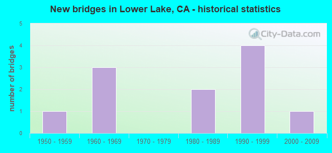
- New bridges - historical statistics
- 11950-1959
- 31960-1969
- 21980-1989
- 41990-1999
- 12000-2009


- Bridge Condition - Deck
- 22.2%Good
- 66.7%Fair
- 11.1%Poor

- Bridge Condition - Superstructure
- 50.0%Good
- 10.0%Satisfactory
- 40.0%Fair

- Bridge Condition - Substructure
- 70.0%Good
- 10.0%Satisfactory
- 20.0%Fair

- Bridge Condition - Channel
- 18.2%Excellent
- 36.4%Very good
- 18.2%Good
- 27.3%Satisfactory
Find on map >> Show street view
Structure Number: 14 0054, Location: 01-LAK-053-0.02 (Lat: 38.910375, Lng: -122.612108), Route carried "on" structure: State highway 53, Year Built: 1952, Year Reconstructed: 1997, Status: Open, Structure Length: 1.08m (3.54ft), Average Daily Traffic: 16,500 (year 2009), Truck Traffic: 5%, Average Future Daily Traffic: 27,567 (year 2040), Design Load: H 20, Features Intersected: SEIGLER CREEK
Minimum Vertical Clearance: 30+ m (98+ ft), Kilometerpoint: 0.020, Lanes on structure: 6, Base Highway Network: Yes (, Subroute: 1), Owner: State Highway Agency, Approaching Roadway Width: 27.4m (89.9ft), Material/Design: Concrete, Design/Construction: Slab, Number Of Spans In Main Unit: 1, Length of Maximum Span: 10.5m (34.4ft), Curb or Sidewalk Widths: Left: 1.8m (5.9ft), Right: 1.8m (5.9ft), Curb-To-Curb Width: 27.4m (89.9ft), Out-to-Out Width: 31.7m (104.0ft)
Condition: Deck: Fair, Superstructure: Fair, Substructure: Good, Channel: Very good, Operating Rating: 58.3 metric tons, Method Used To Determine Operating Rating: Load Factor (LF), Inventory Rating: 35.0 metric tons, Method Used To Determine Inventory Rating: Load Factor (LF), Structural Evaluation: Somewhat better than minimum adequacy, Deck Geometry: Better than present minimum criteria, Waterway Adequacy: Equal to present desirable criteria, Approach Roadway Alignment: Equal to present minimum criteria, Length Of Structure Improvement: 1.07m (3.51ft), Designated Inspection Frequency: Every 24 months, Inspection Date: October 2020, Deck Structure Type: Concrete Cast-file-Place, Wearing Surface/Protective System: Wearing Surface: Bituminous
Find on map >> Show street view
Structure Number: 14 0058, Location: 01-LAK-029-20.37 (Lat: 38.910239, Lng: -122.613497), Route carried "on" structure: State highway 29, Year Built: 1991, Status: Open, Structure Length: 2.23m (7.32ft), Average Daily Traffic: 10,600 (year 2009), Truck Traffic: 6%, Average Future Daily Traffic: 20,078 (year 2042), Design Load: HS 20+Mod, Features Intersected: SEIGLER CREEK
Minimum Vertical Clearance: 30+ m (98+ ft), Kilometerpoint: 20.370, Lanes on structure: 4, Base Highway Network: Yes (, Subroute: 1), Owner: State Highway Agency, Approaching Roadway Width: 18.9m (62.0ft), Skew: 3 degrees, Material/Design: Prestressed concrete, Design/Construction: Box Beam or Girders - Multiple, Number Of Spans In Main Unit: 1, Length of Maximum Span: 21.7m (71.2ft), Curb-To-Curb Width: 17.8m (58.4ft), Out-to-Out Width: 18.9m (62.0ft)
Condition: Deck: Poor, Superstructure: Satisfactory, Substructure: Good, Channel: Excellent, Operating Rating: 54.1 metric tons, Method Used To Determine Operating Rating: Assigned rating based on Load Factor Design (LFD) reported in metric tons, Inventory Rating: 32.4 metric tons, Method Used To Determine Inventory Rating: Assigned rating based on Load Factor Design (LFD) reported in metric tons, Structural Evaluation: Equal to present minimum criteria, Deck Geometry: Somewhat better than minimum adequacy, Waterway Adequacy: Equal to present desirable criteria, Approach Roadway Alignment: Equal to present minimum criteria, Length Of Structure Improvement: 2.23m (7.32ft), Designated Inspection Frequency: Every 24 months, Inspection Date: October 2020, Bridge Improvement Cost: $420,000, Roadway Improvement Cost: $84,000, Total Project Cost: $705,000 ( Estimate for 2019), Deck Structure Type: Concrete Cast-file-Place
Find on map >> Show street view
Structure Number: 14 0078L, Location: 01-LAK-053-1.10 (Lat: 38.925028, Lng: -122.614619), Route carried "on" structure: State highway 53, Year Built: 1997, Status: Open, Structure Length: 6.20m (20.34ft), Average Daily Traffic: 8,500 (year 2009), Truck Traffic: 6%, Average Future Daily Traffic: 13,783 (year 2040), Design Load: HS 20+Mod, Features Intersected: CACHE CREEK
Minimum Vertical Clearance: 30+ m (98+ ft), Kilometerpoint: 1.100, Lanes on structure: 2, Base Highway Network: Yes (, Subroute: 1), Owner: State Highway Agency, Approaching Roadway Width: 11.9m (39.0ft), Skew: 3 degrees, Material/Design: Prestressed concrete, Design/Construction: Box Beam or Girders - Multiple, Number Of Spans In Main Unit: 1, Length of Maximum Span: 61.1m (200.5ft), Curb-To-Curb Width: 11.9m (39.0ft), Out-to-Out Width: 13.0m (42.7ft)
Condition: Deck: Fair, Superstructure: Fair, Substructure: Good, Channel: Very good, Operating Rating: 54.1 metric tons, Method Used To Determine Operating Rating: Assigned rating based on Load Factor Design (LFD) reported in metric tons, Inventory Rating: 32.4 metric tons, Method Used To Determine Inventory Rating: Assigned rating based on Load Factor Design (LFD) reported in metric tons, Structural Evaluation: Somewhat better than minimum adequacy, Deck Geometry: Better than present minimum criteria, Waterway Adequacy: Equal to present desirable criteria, Approach Roadway Alignment: Equal to present desirable criteria, Designated Inspection Frequency: Every 24 months, Inspection Date: October 2020, Deck Structure Type: Concrete Cast-file-Place
Find on map >> Show street view
Structure Number: 14 0078R, Location: 01-LAK-053-1.00 (Lat: 38.925003, Lng: -122.614350), Route carried "on" structure: State highway 53, Year Built: 1997, Status: Open, Structure Length: 6.57m (21.56ft), Average Daily Traffic: 8,250 (year 2009), Truck Traffic: 5%, Average Future Daily Traffic: 13,783 (year 2040), Design Load: HS 20+Mod, Features Intersected: CACHE CREEK
Minimum Vertical Clearance: 30+ m (98+ ft), Kilometerpoint: 1.000, Lanes on structure: 2, Base Highway Network: Yes (, Subroute: 1), Owner: State Highway Agency, Approaching Roadway Width: 11.9m (39.0ft), Skew: 3 degrees, Material/Design: Prestressed concrete, Design/Construction: Box Beam or Girders - Multiple, Number Of Spans In Main Unit: 1, Length of Maximum Span: 64.8m (212.6ft), Curb-To-Curb Width: 11.9m (39.0ft), Out-to-Out Width: 13.0m (42.7ft)
Condition: Deck: Fair, Superstructure: Good, Substructure: Good, Channel: Very good, Operating Rating: 54.1 metric tons, Method Used To Determine Operating Rating: Assigned rating based on Load Factor Design (LFD) reported in metric tons, Inventory Rating: 32.4 metric tons, Method Used To Determine Inventory Rating: Assigned rating based on Load Factor Design (LFD) reported in metric tons, Structural Evaluation: Better than present minimum criteria, Deck Geometry: Better than present minimum criteria, Waterway Adequacy: Equal to present desirable criteria, Approach Roadway Alignment: Equal to present desirable criteria, Designated Inspection Frequency: Every 24 months, Inspection Date: October 2020, Deck Structure Type: Concrete Cast-file-Place
Find on map >> Show street view
Structure Number: 14C0006, Location: 1.0 MI E SR 29 & SR 53 (Lat: 38.907942, Lng: -122.594764), Route carried "on" structure: County highway , Year Built: 1965, Status: Open, Structure Length: 1.68m (5.51ft), Average Daily Traffic: 1,800 (year 2011), Truck Traffic: 2%, Average Future Daily Traffic: 2,047 (year 2041), Features Intersected: COPSEY CREEK, Facility Carried by Structure: MORGAN VALLEY RD
Minimum Vertical Clearance: 30+ m (98+ ft), Kilometerpoint: 0.000, Lanes on structure: 2, Owner: County Highway Agency, Approaching Roadway Width: 7.0m (23.0ft), Skew: 3 degrees, Material/Design: Steel, Design/Construction: Arch - Deck, Number Of Spans In Main Unit: 1, Length of Maximum Span: 16.8m (55.1ft)
Condition: Superstructure: Good, Substructure: Fair, Channel: Good, Operating Rating: 40.5 metric tons, Method Used To Determine Operating Rating: Field evaluation and documented engineering judgment, Inventory Rating: 24.3 metric tons, Method Used To Determine Inventory Rating: Field evaluation and documented engineering judgment, Structural Evaluation: Somewhat better than minimum adequacy, Waterway Adequacy: Better than present minimum criteria, Approach Roadway Alignment: Better than present minimum criteria, Designated Inspection Frequency: Every 24 months, Inspection Date: November 2021
Find on map >> Show street view
Structure Number: 14C0024, Location: 0.03 MI S/O DAM ROAD (Lat: 38.925314, Lng: -122.611619), Route carried "on" structure: Business County highway , Year Built: 1987, Status: Open, Structure Length: 4.11m (13.48ft), Average Daily Traffic: 1,700 (year 2011), Truck Traffic: 2%, Average Future Daily Traffic: 2,359 (year 2043), Design Load: HS 20+Mod, Features Intersected: CACHE CREEK, Facility Carried by Structure: LAKE ST
Minimum Vertical Clearance: 30+ m (98+ ft), Kilometerpoint: 0.000, Lanes on structure: 2, Owner: County Highway Agency, Approaching Roadway Width: 12.0m (39.4ft), Skew: 1 degrees, Material/Design: Prestressed concrete, Design/Construction: Box Beam or Girders - Multiple, Number Of Spans In Main Unit: 1, Length of Maximum Span: 40.4m (132.5ft), Curb or Sidewalk Widths: Left: 0.0m, Right: 1.5m (4.9ft), Curb-To-Curb Width: 11.0m (36.1ft), Out-to-Out Width: 13.3m (43.6ft)
Condition: Deck: Fair, Superstructure: Good, Substructure: Good, Channel: Good, Operating Rating: 54.1 metric tons, Method Used To Determine Operating Rating: Assigned rating based on Load Factor Design (LFD) reported in metric tons, Inventory Rating: 32.4 metric tons, Method Used To Determine Inventory Rating: Assigned rating based on Load Factor Design (LFD) reported in metric tons, Structural Evaluation: Better than present minimum criteria, Deck Geometry: Equal to present minimum criteria, Waterway Adequacy: Superior to present desirable criteria, Approach Roadway Alignment: Better than present minimum criteria, Designated Inspection Frequency: Every 24 months, Inspection Date: November 2021, Deck Structure Type: Concrete Cast-file-Place
Find on map >> Show street view
Structure Number: 14C0039, Location: S SR 29 IN LOWER LAKE (Lat: 38.909094, Lng: -122.616658), Route carried "on" structure: County highway , Year Built: 1966, Status: Open, Structure Length: 2.34m (7.68ft), Average Daily Traffic: 200 (year 2006), Truck Traffic: 2%, Average Future Daily Traffic: 337 (year 2043), Design Load: HS 20, Features Intersected: SEIGLER CREEK, Facility Carried by Structure: BELL PARK AVE
Minimum Vertical Clearance: 30+ m (98+ ft), Kilometerpoint: 0.000, Lanes on structure: 2, Owner: County Highway Agency, Approaching Roadway Width: 8.5m (27.9ft), Skew: 9 degrees, Material/Design: Concrete continuous, Design/Construction: Slab, Number Of Spans In Main Unit: 3, Length of Maximum Span: 9.1m (29.9ft), Curb or Sidewalk Widths: Left: 0.6m (2.0ft), Right: 0.6m (2.0ft), Curb-To-Curb Width: 8.5m (27.9ft), Out-to-Out Width: 10.4m (34.1ft)
Condition: Deck: Fair, Superstructure: Fair, Substructure: Good, Channel: Satisfactory, Operating Rating: 59.3 metric tons, Method Used To Determine Operating Rating: Load Factor (LF), Inventory Rating: 35.6 metric tons, Method Used To Determine Inventory Rating: Load Factor (LF), Structural Evaluation: Somewhat better than minimum adequacy, Deck Geometry: Equal to present minimum criteria, Waterway Adequacy: Better than present minimum criteria, Approach Roadway Alignment: Somewhat better than minimum adequacy, Designated Inspection Frequency: Every 24 months, Inspection Date: November 2021, Deck Structure Type: Concrete Cast-file-Place
Find on map >> Show street view
Structure Number: 14C0093, Location: 0.05 MI W QUARTERHORSE LN (Lat: 38.914214, Lng: -122.593711), Route carried "on" structure: County highway , Year Built: 1965, Status: Open, Structure Length: 2.41m (7.91ft), Average Daily Traffic: 200 (year 2006), Truck Traffic: 3%, Average Future Daily Traffic: 331 (year 2043), Features Intersected: COPSEY CREEK, Facility Carried by Structure: COPSEY CREEK WAY
Minimum Vertical Clearance: 30+ m (98+ ft), Kilometerpoint: 0.000, Lanes on structure: 2, Owner: County Highway Agency, Approaching Roadway Width: 8.6m (28.2ft), Material/Design: Concrete continuous, Design/Construction: Slab, Number Of Spans In Main Unit: 3, Length of Maximum Span: 7.9m (25.9ft), Curb-To-Curb Width: 8.5m (27.9ft), Out-to-Out Width: 8.6m (28.2ft)
Condition: Deck: Fair, Superstructure: Fair, Substructure: Fair, Channel: Satisfactory, Operating Rating: 37.9 metric tons, Method Used To Determine Operating Rating: Field evaluation and documented engineering judgment, Inventory Rating: 22.7 metric tons, Method Used To Determine Inventory Rating: Field evaluation and documented engineering judgment, Structural Evaluation: Somewhat better than minimum adequacy, Deck Geometry: Equal to present minimum criteria, Waterway Adequacy: Better than present minimum criteria, Approach Roadway Alignment: Somewhat better than minimum adequacy, Designated Inspection Frequency: Every 24 months, Inspection Date: November 2021, Deck Structure Type: Concrete Cast-file-Place
Find on map >> Show street view
Structure Number: 14C0094, Location: 0.1 MI E OF SR 53 (Lat: 38.913636, Lng: -122.610150), Route carried "on" structure: County highway , Year Built: 1987, Status: Open, Structure Length: 1.30m (4.27ft), Average Daily Traffic: 300 (year 2006), Truck Traffic: 2%, Average Future Daily Traffic: 508 (year 2037), Features Intersected: SEIGLER CANYON CREEK, Facility Carried by Structure: JESSIE ST
Minimum Vertical Clearance: 30+ m (98+ ft), Kilometerpoint: 0.000, Lanes on structure: 2, Owner: County Highway Agency, Approaching Roadway Width: 9.9m (32.5ft), Skew: 3 degrees, Material/Design: Concrete continuous, Design/Construction: Culvert, Number Of Spans In Main Unit: 3, Length of Maximum Span: 4.2m (13.8ft), Curb-To-Curb Width: 9.8m (32.2ft), Out-to-Out Width: 10.4m (34.1ft)
Condition: Channel: Very good, Culverts: Satisfactory, Operating Rating: 54.1 metric tons, Method Used To Determine Operating Rating: Field evaluation and documented engineering judgment, Inventory Rating: 32.4 metric tons, Method Used To Determine Inventory Rating: Field evaluation and documented engineering judgment, Structural Evaluation: Equal to present minimum criteria, Deck Geometry: Better than present minimum criteria, Waterway Adequacy: Meets minimum limits, Approach Roadway Alignment: Equal to present desirable criteria, Designated Inspection Frequency: Every 48 months, Inspection Date: November 2019, Deck Structure Type: Concrete Cast-file-Place
Find on map >> Show street view
Structure Number: 14C0117, Location: 0.3 MI EAST OF SR 29 (Lat: 38.888647, Lng: -122.597697), Route carried "on" structure: County highway , Year Built: 1995, Status: Open, Structure Length: 3.11m (10.20ft), Average Daily Traffic: 512 (year 2008), Truck Traffic: 5%, Average Future Daily Traffic: 651 (year 2038), Design Load: HS 20+Mod, Features Intersected: COPSEY CREEK, Facility Carried by Structure: SPRUCE GROVE ROAD
Minimum Vertical Clearance: 30+ m (98+ ft), Kilometerpoint: 0.000, Lanes on structure: 2, Owner: County Highway Agency, Approaching Roadway Width: 6.7m (22.0ft), Material/Design: Steel continuous, Design/Construction: Stringer/Multi-beam, Number Of Spans In Main Unit: 3, Length of Maximum Span: 10.4m (34.1ft), Curb-To-Curb Width: 7.3m (24.0ft), Out-to-Out Width: 7.8m (25.6ft)
Condition: Deck: Good, Superstructure: Good, Substructure: Satisfactory, Channel: Satisfactory, Operating Rating: 68.7 metric tons, Method Used To Determine Operating Rating: Load Factor (LF), Inventory Rating: 41.1 metric tons, Method Used To Determine Inventory Rating: Load Factor (LF), Structural Evaluation: Equal to present minimum criteria, Deck Geometry: Meets minimum limits, Waterway Adequacy: Superior to present desirable criteria, Approach Roadway Alignment: Equal to present desirable criteria, Length Of Structure Improvement: 3.11m (10.20ft), Designated Inspection Frequency: Every 48 months, Inspection Date: November 2019, Deck Structure Type: Corrugated Steel, Wearing Surface/Protective System: Wearing Surface: Bituminous
Find on map >> Show street view
Structure Number: 14C0121, Location: AT SEIGLER CYN RD (Lat: 38.903214, Lng: -122.639233), Route carried "on" structure: County highway , Year Built: 2007, Status: Open, Structure Length: 0.94m (3.08ft), Average Daily Traffic: 75 (year 2006), Average Future Daily Traffic: 128 (year 2037), Design Load: HS 20, Features Intersected: SEIGLER CANYON CREEK, Facility Carried by Structure: PERINI ROAD
Minimum Vertical Clearance: 30+ m (98+ ft), Kilometerpoint: 0.000, Lanes on structure: 2, Owner: County Highway Agency, Approaching Roadway Width: 6.5m (21.3ft), Material/Design: Steel, Design/Construction: Stringer/Multi-beam, Number Of Spans In Main Unit: 1, Length of Maximum Span: 8.8m (28.9ft), Curb-To-Curb Width: 7.6m (24.9ft), Out-to-Out Width: 7.9m (25.9ft)
Condition: Deck: Good, Superstructure: Good, Substructure: Good, Channel: Excellent, Operating Rating: 62.2 metric tons, Method Used To Determine Operating Rating: Load Factor (LF), Inventory Rating: 37.3 metric tons, Method Used To Determine Inventory Rating: Load Factor (LF), Structural Evaluation: Better than present minimum criteria, Deck Geometry: Equal to present minimum criteria, Waterway Adequacy: Better than present minimum criteria, Approach Roadway Alignment: Equal to present desirable criteria, Designated Inspection Frequency: Every 48 months, Inspection Date: November 2019, Deck Structure Type: Corrugated Steel, Wearing Surface/Protective System: Wearing Surface: Bituminous