Bridge Statistics for Lucerne, Wyoming (WY)
Condition, Traffic, Stress, Structural Evaluation, Project Costs
- National Bridge Inventory (NBI) Statistics
- 10Number of bridges
- 98ft / 30.1mTotal length
- $260,000Total costs
- 12,903Total average daily traffic
- 1,702Total average daily truck traffic
- 18,065Total future (year 2041) average daily traffic
- National Bridge Inventory (NBI) Registered Bridges for Lucerne
- No street view available for this location
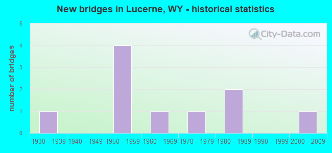
- New bridges - historical statistics
- 11930-1939
- 41950-1959
- 11960-1969
- 11970-1979
- 21980-1989
- 12000-2009


- Bridge Condition - Deck
- 14.3%Very good
- 14.3%Good
- 42.9%Satisfactory
- 28.6%Fair

- Bridge Condition - Superstructure
- 14.3%Very good
- 57.1%Good
- 14.3%Satisfactory
- 14.3%Fair

- Bridge Condition - Substructure
- 14.3%Very good
- 42.9%Good
- 42.9%Satisfactory

- Bridge Condition - Channel
- 20.0%Very good
- 70.0%Good
- 10.0%Satisfactory

- Bridge Condition - Culverts
- 33.3%Good
- 66.7%Satisfactory
Find on map >> Show street view
Structure Number: CAK, Location: Thermopolis - Cody (Lat: 43.656986, Lng: -108.263267), Route carried "on" structure: State highway 120, Year Built: 1961, Status: Open, Structure Length: 0.91m (2.99ft), Average Daily Traffic: 1,790 (year 2021), Truck Traffic: 11%, Average Future Daily Traffic: 2,506 (year 2041), Design Load: HS 20, Features Intersected: Unnamed Draw
Minimum Vertical Clearance: 30+ m (98+ ft), Kilometerpoint: 5.776, Lanes on structure: 2, Base Highway Network: Yes, Owner: State Highway Agency, Approaching Roadway Width: 7.0m (23.0ft), Skew: 2 degrees, Material/Design: Concrete continuous, Design/Construction: Culvert, Number Of Spans In Main Unit: 3, Length of Maximum Span: 3.2m (10.5ft)
Condition: Channel: Satisfactory, Culverts: Satisfactory, Operating Rating: 32.7 metric tons, Method Used To Determine Operating Rating: Field evaluation and documented engineering judgment, Inventory Rating: 32.7 metric tons, Method Used To Determine Inventory Rating: Field evaluation and documented engineering judgment, Structural Evaluation: Equal to present minimum criteria, Waterway Adequacy: Equal to present desirable criteria, Approach Roadway Alignment: Equal to present desirable criteria, Designated Inspection Frequency: Every 24 months, Inspection Date: April 2020
Find on map >> Show street view
Structure Number: CCC, Location: Thermopolis - Worland (Lat: 43.674269, Lng: -108.205819), Route carried "on" structure: US 20, Year Built: 1976, Status: Open, Structure Length: 1.86m (6.10ft), Average Daily Traffic: 2,805 (year 2021), Truck Traffic: 12%, Average Future Daily Traffic: 3,927 (year 2041), Design Load: HS 20, Features Intersected: Red Lane Draw
Minimum Vertical Clearance: 30+ m (98+ ft), Kilometerpoint: 216.740, Lanes on structure: 2, Base Highway Network: Yes (Inventory Route: ML3, Subroute: 2), Owner: State Highway Agency, Approaching Roadway Width: 14.0m (45.9ft), Skew: 1 degrees, Material/Design: Steel continuous, Design/Construction: Stringer/Multi-beam, Number Of Spans In Main Unit: 2, Length of Maximum Span: 8.8m (28.9ft), Curb-To-Curb Width: 14.2m (46.6ft), Out-to-Out Width: 14.8m (48.6ft)
Condition: Deck: Fair, Superstructure: Fair, Substructure: Good, Channel: Good, Operating Rating: 54.4 metric tons, Method Used To Determine Operating Rating: Load Factor (LF), Inventory Rating: 32.7 metric tons, Method Used To Determine Inventory Rating: Load Factor (LF), Structural Evaluation: Somewhat better than minimum adequacy, Deck Geometry: Superior to present desirable criteria, Waterway Adequacy: Better than present minimum criteria, Approach Roadway Alignment: Better than present minimum criteria, Length Of Structure Improvement: 2.56m (8.40ft), Designated Inspection Frequency: Every 24 months, Inspection Date: April 2020, Bridge Improvement Cost: $45,000, Roadway Improvement Cost: $5,000, Total Project Cost: $67,000 ( Estimate for 2014), Deck Structure Type: Concrete Cast-file-Place
Find on map >> Show street view
Structure Number: CCE, Location: Thermopolis - Worland (Lat: 43.714931, Lng: -108.176375), Route carried "on" structure: US 20, Year Built: 1937, Year Reconstructed: 1959, Status: Open, Structure Length: 4.51m (14.80ft), Average Daily Traffic: 2,282 (year 2021), Truck Traffic: 12%, Average Future Daily Traffic: 3,195 (year 2041), Design Load: HS 20, Features Intersected: Owl Creek
Minimum Vertical Clearance: 30+ m (98+ ft), Kilometerpoint: 222.181, Lanes on structure: 2, Base Highway Network: Yes (Inventory Route: ML3, Subroute: 3), Owner: State Highway Agency, Approaching Roadway Width: 11.0m (36.1ft), Material/Design: Steel, Design/Construction: Stringer/Multi-beam, Number Of Spans In Main Unit: 1, Number Of Approach Spans: 2, Length of Maximum Span: 24.4m (80.1ft), Curb-To-Curb Width: 9.8m (32.2ft), Out-to-Out Width: 10.7m (35.1ft)
Condition: Deck: Satisfactory, Superstructure: Satisfactory, Substructure: Satisfactory, Channel: Good, Operating Rating: 64.4 metric tons, Method Used To Determine Operating Rating: Load Factor (LF), Inventory Rating: 38.1 metric tons, Method Used To Determine Inventory Rating: Load Factor (LF), Structural Evaluation: Equal to present minimum criteria, Deck Geometry: Meets minimum limits, Waterway Adequacy: Equal to present desirable criteria, Approach Roadway Alignment: Equal to present desirable criteria, Designated Inspection Frequency: Every 24 months, Inspection Date: April 2020, Bridge Improvement Cost: $72,000, Roadway Improvement Cost: $7,000, Total Project Cost: $108,000 ( Estimate for 2016), Deck Structure Type: Concrete Cast-file-Place, Wearing Surface/Protective System: Wearing Surface: Latex Concrete
Find on map >> Show street view
Structure Number: CCF, Location: Thermopolis - Worland (Lat: 43.734703, Lng: -108.176197), Route carried "on" structure: US 20, Year Built: 1956, Status: Open, Structure Length: 0.63m (2.07ft), Average Daily Traffic: 2,282 (year 2021), Truck Traffic: 12%, Average Future Daily Traffic: 3,195 (year 2041), Design Load: HS 20, Features Intersected: Unnamed Draw
Minimum Vertical Clearance: 30+ m (98+ ft), Kilometerpoint: 224.378, Lanes on structure: 2, Base Highway Network: Yes (Inventory Route: ML3, Subroute: 3), Owner: State Highway Agency, Approaching Roadway Width: 12.8m (42.0ft), Material/Design: Concrete continuous, Design/Construction: Culvert, Number Of Spans In Main Unit: 2, Length of Maximum Span: 3.0m (9.8ft)
Condition: Channel: Good, Culverts: Satisfactory, Operating Rating: 32.7 metric tons, Method Used To Determine Operating Rating: Field evaluation and documented engineering judgment, Inventory Rating: 32.7 metric tons, Method Used To Determine Inventory Rating: Field evaluation and documented engineering judgment, Structural Evaluation: Equal to present minimum criteria, Waterway Adequacy: Better than present minimum criteria, Approach Roadway Alignment: Equal to present desirable criteria, Designated Inspection Frequency: Every 24 months, Inspection Date: April 2020
Find on map >> Show street view
Structure Number: CPX, Location: Lucerne - East (Lat: 43.735575, Lng: -108.161311), Route carried "on" structure: State highway 172, Year Built: 1959, Status: Open, Structure Length: 10.73m (35.20ft), Average Daily Traffic: 787 (year 2021), Truck Traffic: 23%, Average Future Daily Traffic: 1,102 (year 2041), Design Load: HS 20, Features Intersected: Big Horn River
Minimum Vertical Clearance: 30+ m (98+ ft), Kilometerpoint: 1.209, Lanes on structure: 2, Owner: State Highway Agency, Approaching Roadway Width: 8.5m (27.9ft), Material/Design: Steel continuous, Design/Construction: Stringer/Multi-beam, Number Of Spans In Main Unit: 4, Length of Maximum Span: 29.3m (96.1ft), Curb-To-Curb Width: 9.1m (29.9ft), Out-to-Out Width: 10.1m (33.1ft)
Condition: Deck: Fair, Superstructure: Good, Substructure: Satisfactory, Channel: Good, Operating Rating: 74.4 metric tons, Method Used To Determine Operating Rating: Load Factor (LF), Inventory Rating: 44.5 metric tons, Method Used To Determine Inventory Rating: Load Factor (LF), Structural Evaluation: Equal to present minimum criteria, Deck Geometry: Equal to present minimum criteria, Waterway Adequacy: Equal to present desirable criteria, Approach Roadway Alignment: Equal to present desirable criteria, Designated Inspection Frequency: Every 24 months, Underwater Inspection Frequency: Every 60 months, Inspection Date: April 2020, Underwater Inspection Date: August 2019, Deck Structure Type: Concrete Cast-file-Place
Find on map >> Show street view
Structure Number: CPY, Location: Lucerne - East (Lat: 43.738322, Lng: -108.139539), Route carried "on" structure: State highway 172, Year Built: 1953, Status: Open, Structure Length: 3.98m (13.06ft), Average Daily Traffic: 787 (year 2021), Truck Traffic: 23%, Average Future Daily Traffic: 1,102 (year 2041), Design Load: H 20, Features Intersected: Kirby Creek
Minimum Vertical Clearance: 30+ m (98+ ft), Kilometerpoint: 3.035, Lanes on structure: 2, Owner: State Highway Agency, Approaching Roadway Width: 8.5m (27.9ft), Material/Design: Concrete continuous, Design/Construction: Slab, Number Of Spans In Main Unit: 5, Length of Maximum Span: 8.4m (27.6ft), Curb-To-Curb Width: 8.5m (27.9ft), Out-to-Out Width: 9.5m (31.2ft)
Condition: Deck: Good, Superstructure: Good, Substructure: Satisfactory, Channel: Good, Operating Rating: 43.5 metric tons, Method Used To Determine Operating Rating: Load Factor (LF), Inventory Rating: 26.1 metric tons, Method Used To Determine Inventory Rating: Load Factor (LF), Structural Evaluation: Equal to present minimum criteria, Deck Geometry: Somewhat better than minimum adequacy, Waterway Adequacy: Equal to present desirable criteria, Approach Roadway Alignment: Better than present minimum criteria, Length Of Structure Improvement: 3.99m (13.09ft), Designated Inspection Frequency: Every 24 months, Inspection Date: April 2020, Bridge Improvement Cost: $50,000, Roadway Improvement Cost: $10,000, Total Project Cost: $75,000 ( Estimate for 2015), Deck Structure Type: Concrete Cast-file-Place, Wearing Surface/Protective System: Wearing Surface: Latex Concrete
Find on map >> Show street view
Structure Number: FBH, Location: Thermopolis-Meeteetse (Lat: 43.685572, Lng: -108.305192), Route carried "on" structure: State highway 120, Year Built: 1986, Status: Open, Structure Length: 4.72m (15.49ft), Average Daily Traffic: 1,753 (year 2021), Truck Traffic: 12%, Average Future Daily Traffic: 2,454 (year 2041), Design Load: HS 20, Features Intersected: Owl Creek
Minimum Vertical Clearance: 30+ m (98+ ft), Kilometerpoint: 10.538, Lanes on structure: 2, Base Highway Network: Yes (Inventory Route: ML3, Subroute: 1), Owner: State Highway Agency, Approaching Roadway Width: 12.2m (40.0ft), Skew: 3 degrees, Material/Design: Steel continuous, Design/Construction: Stringer/Multi-beam, Number Of Spans In Main Unit: 3, Length of Maximum Span: 17.7m (58.1ft), Curb-To-Curb Width: 12.2m (40.0ft), Out-to-Out Width: 13.1m (43.0ft)
Condition: Deck: Satisfactory, Superstructure: Good, Substructure: Good, Channel: Very good, Operating Rating: 57.2 metric tons, Method Used To Determine Operating Rating: Load Factor (LF), Inventory Rating: 34.5 metric tons, Method Used To Determine Inventory Rating: Load Factor (LF), Structural Evaluation: Better than present minimum criteria, Deck Geometry: Better than present minimum criteria, Waterway Adequacy: Equal to present desirable criteria, Approach Roadway Alignment: Equal to present desirable criteria, Designated Inspection Frequency: Every 24 months, Inspection Date: Febuary 2021, Deck Structure Type: Concrete Cast-file-Place
Find on map >> Show street view
Structure Number: FLP, Location: 9 Mi. Ne Of Thermopolis (Lat: 43.743769, Lng: -108.155478), Route carried "on" structure: County highway 21, Year Built: 1988, Status: Open, Structure Length: 1.22m (4.00ft), Average Daily Traffic: 65 (year 2021), Truck Traffic: 8%, Average Future Daily Traffic: 91 (year 2041), Design Load: HS 20, Features Intersected: Kirby Creek
Minimum Vertical Clearance: 30+ m (98+ ft), Kilometerpoint: 0.732, Lanes on structure: 2, Owner: County Highway Agency, Approaching Roadway Width: 7.9m (25.9ft), Skew: 1 degrees, Material/Design: Steel, Design/Construction: Stringer/Multi-beam, Number Of Spans In Main Unit: 1, Length of Maximum Span: 11.3m (37.1ft), Curb-To-Curb Width: 7.9m (25.9ft), Out-to-Out Width: 8.7m (28.5ft)
Condition: Deck: Satisfactory, Superstructure: Good, Substructure: Good, Channel: Good, Operating Rating: 40.8 metric tons, Method Used To Determine Operating Rating: Allowable Stress (AS), Inventory Rating: 26.3 metric tons, Method Used To Determine Inventory Rating: Allowable Stress (AS), Structural Evaluation: Equal to present minimum criteria, Deck Geometry: Equal to present minimum criteria, Waterway Adequacy: Equal to present desirable criteria, Approach Roadway Alignment: Better than present minimum criteria, Length Of Structure Improvement: 0.61m (2.00ft), Designated Inspection Frequency: Every 24 months, Inspection Date: Febuary 2021, Bridge Improvement Cost: $5,000, Roadway Improvement Cost: $1,000, Total Project Cost: $7,000, Deck Structure Type: Concrete Cast-file-Place, Wearing Surface/Protective System: Deck Protection: Epoxy Coated Reinforcing
Find on map >> Show street view
Structure Number: LCT, Location: Lucerne - East (Lat: 43.739094, Lng: -108.135697), Route carried "on" structure: State highway 172, Year Built: 1953, Status: Open, Structure Length: 0.63m (2.07ft), Average Daily Traffic: 215 (year 2021), Truck Traffic: 16%, Average Future Daily Traffic: 301 (year 2041), Design Load: H 20, Features Intersected: Kirby Ditch
Minimum Vertical Clearance: 30+ m (98+ ft), Kilometerpoint: 3.360, Lanes on structure: 2, Owner: State Highway Agency, Approaching Roadway Width: 8.5m (27.9ft), Skew: 4 degrees, Material/Design: Concrete, Design/Construction: Culvert, Number Of Spans In Main Unit: 2, Length of Maximum Span: 2.1m (6.9ft)
Condition: Channel: Very good, Culverts: Good, Operating Rating: 32.7 metric tons, Method Used To Determine Operating Rating: Field evaluation and documented engineering judgment, Inventory Rating: 32.7 metric tons, Method Used To Determine Inventory Rating: Field evaluation and documented engineering judgment, Structural Evaluation: Better than present minimum criteria, Waterway Adequacy: Equal to present desirable criteria, Approach Roadway Alignment: Equal to present desirable criteria, Designated Inspection Frequency: Every 24 months, Inspection Date: April 2020
Find on map >> Show street view
Structure Number: LHJ, Location: 8 Miles Nw Of Thermopolis (Lat: 43.701017, Lng: -108.225353), Route carried "on" structure: County highway 27, Year Built: 2001, Status: Open, Structure Length: 0.90m (2.95ft), Average Daily Traffic: 137 (year 2021), Truck Traffic: 10%, Average Future Daily Traffic: 192 (year 2041), Design Load: HS 25 or greater, Features Intersected: Owl Creek
Minimum Vertical Clearance: 30+ m (98+ ft), Kilometerpoint: 6.714, Lanes on structure: 2, Owner: County Highway Agency, Approaching Roadway Width: 8.0m (26.2ft), Material/Design: Prestressed concrete, Design/Construction: Tee Beam, Number Of Spans In Main Unit: 1, Length of Maximum Span: 8.2m (26.9ft), Curb-To-Curb Width: 8.0m (26.2ft), Out-to-Out Width: 8.8m (28.9ft)
Condition: Deck: Very good, Superstructure: Very good, Substructure: Very good, Channel: Good, Operating Rating: 72.6 metric tons, Method Used To Determine Operating Rating: Load Factor (LF), Inventory Rating: 43.5 metric tons, Method Used To Determine Inventory Rating: Load Factor (LF), Structural Evaluation: Equal to present desirable criteria, Deck Geometry: Somewhat better than minimum adequacy, Waterway Adequacy: Equal to present desirable criteria, Approach Roadway Alignment: Equal to present minimum criteria, Length Of Structure Improvement: 0.15m (0.49ft), Designated Inspection Frequency: Every 24 months, Inspection Date: Febuary 2021, Bridge Improvement Cost: $1,000, Roadway Improvement Cost: $1,000, Total Project Cost: $3,000, Deck Structure Type: Concrete Precast Panels, Wearing Surface/Protective System: Deck Protection: Epoxy Coated Reinforcing