Bridge Statistics for Mapleton, Illinois (IL)
Condition, Traffic, Stress, Structural Evaluation, Project Costs
- National Bridge Inventory (NBI) Statistics
- 13Number of bridges
- 236ft / 72.1mTotal length
- 64,275Total average daily traffic
- 4,843Total average daily truck traffic
- National Bridge Inventory (NBI) Registered Bridges for Mapleton
- No street view available for this location
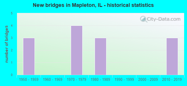
- New bridges - historical statistics
- 31950-1959
- 41970-1979
- 31980-1989
- 32010-2019

- Reconstructed bridges - Historical Statistics
- 11970-1979
- 01980-1989
- 01990-1999
- 02000-2009
- 12010-2019


- Bridge Condition - Deck
- 36.4%Good
- 27.3%Fair
- 18.2%Poor
- 9.1%Serious
- 9.1%Critical

- Bridge Condition - Superstructure
- 9.1%Very good
- 18.2%Good
- 18.2%Satisfactory
- 18.2%Fair
- 27.3%Poor
- 9.1%Critical

- Bridge Condition - Substructure
- 18.2%Very good
- 27.3%Good
- 27.3%Satisfactory
- 27.3%Fair

- Bridge Condition - Channel
- 22.2%Good
- 66.7%Satisfactory
- 11.1%Fair
Find on map >> Show street view
Structure Number: 720008, Location: 1 MI W OF MAPLETON (Lat: 40.562700, Lng: -89.743942), Route carried "on" structure: US 24, Year Built: 1955, Status: Temporarily open, Structure Length: 3.81m (12.50ft), Average Daily Traffic: 11,000 (year 2021), Truck Traffic: 7%, Average Future Daily Traffic: 6,478 (year 2032), Design Load: HS 20, Features Intersected: LITTLE LAMARSH CR
Minimum Vertical Clearance: 30+ m (98+ ft), Kilometerpoint: 187.789, Lanes on structure: 2, Base Highway Network: Yes, Owner: State Highway Agency, Approaching Roadway Width: 13.4m (44.0ft), Skew: 1 degrees, Material/Design: Concrete continuous, Design/Construction: Tee Beam, Number Of Spans In Main Unit: 3, Length of Maximum Span: 14.6m (47.9ft), Curb-To-Curb Width: 12.5m (41.0ft), Out-to-Out Width: 13.4m (44.0ft)
Condition: Deck: Critical, Superstructure: Critical, Substructure: Satisfactory, Channel: Satisfactory, Operating Rating: 8.7 metric tons, Method Used To Determine Operating Rating: Load Factor (LF) rating reported by rating factor (RF) method using MS18 loading, Inventory Rating: 5.2 metric tons, Method Used To Determine Inventory Rating: Load Factor (LF) rating reported by rating factor (RF) method using MS18 loading, Structural Evaluation: High priority of replacement, Deck Geometry: Better than present minimum criteria, Waterway Adequacy: Equal to present desirable criteria, Approach Roadway Alignment: Equal to present desirable criteria, Designated Inspection Frequency: Every 12 months, Other Special Inspection Frequency: Every 12 months, Inspection Date: December 2020, Other Special Inspection Date: December 2020, Deck Structure Type: Concrete Cast-file-Place, Wearing Surface/Protective System: Wearing Surface: Bituminous
Find on map >> Show street view
Structure Number: 720009, Location: 1 MI E OF MAPLETON (Lat: 40.569642, Lng: -89.717003), Route carried "on" structure: US 24, Year Built: 1955, Year Reconstructed: 1977, Status: Open, Structure Length: 10.61m (34.81ft), Average Daily Traffic: 11,500 (year 2021), Truck Traffic: 8%, Average Future Daily Traffic: 6,691 (year 2032), Design Load: HS 20, Features Intersected: KJRY RR & OLD SBI 9
Minimum Vertical Clearance: 30+ m (98+ ft), Kilometerpoint: 190.235, Lanes on structure: 2, Lanes under structure: 2, Base Highway Network: Yes, Owner: State Highway Agency, Approaching Roadway Width: 10.4m (34.1ft), Skew: 5 degrees, Material/Design: Steel continuous, Design/Construction: Stringer/Multi-beam, Number Of Spans In Main Unit: 5, Length of Maximum Span: 28.0m (91.9ft), Curb-To-Curb Width: 11.7m (38.4ft), Out-to-Out Width: 12.7m (41.7ft)
Condition: Deck: Serious, Superstructure: Poor, Substructure: Fair, Operating Rating: 58.3 metric tons, Method Used To Determine Operating Rating: Load Factor (LF) rating reported by rating factor (RF) method using MS18 loading, Inventory Rating: 35.0 metric tons, Method Used To Determine Inventory Rating: Load Factor (LF) rating reported by rating factor (RF) method using MS18 loading, Structural Evaluation: Meets minimum limits, Deck Geometry: Better than present minimum criteria, Underclear: Superior to present desirable criteria, Approach Roadway Alignment: Equal to present minimum criteria, Designated Inspection Frequency: Every 12 months, Other Special Inspection Frequency: Every 6 months, Inspection Date: May 2021, Other Special Inspection Date: November 2021, Deck Structure Type: Concrete Cast-file-Place, Wearing Surface/Protective System: Wearing Surface: Integral Concrete
Find on map >> Show street view
Structure Number: 720135, Location: 1 MI E OF MAPLETON (Lat: 40.569642, Lng: -89.717003), Route carried "on" structure: US 24, Year Built: 1977, Status: Open, Structure Length: 10.61m (34.81ft), Average Daily Traffic: 11,500 (year 2021), Truck Traffic: 8%, Average Future Daily Traffic: 6,691 (year 2032), Design Load: HS 20, Features Intersected: KJRY RR OLD SBI 9
Minimum Vertical Clearance: 30+ m (98+ ft), Kilometerpoint: 190.235, Lanes on structure: 2, Lanes under structure: 2, Base Highway Network: Yes, Owner: State Highway Agency, Approaching Roadway Width: 10.4m (34.1ft), Skew: 5 degrees, Material/Design: Steel continuous, Design/Construction: Stringer/Multi-beam, Number Of Spans In Main Unit: 5, Length of Maximum Span: 28.0m (91.9ft), Curb-To-Curb Width: 11.7m (38.4ft), Out-to-Out Width: 12.7m (41.7ft)
Condition: Deck: Poor, Superstructure: Poor, Substructure: Fair, Operating Rating: 43.7 metric tons, Method Used To Determine Operating Rating: Load Factor (LF) rating reported by rating factor (RF) method using MS18 loading, Inventory Rating: 26.2 metric tons, Method Used To Determine Inventory Rating: Load Factor (LF) rating reported by rating factor (RF) method using MS18 loading, Structural Evaluation: Meets minimum limits, Deck Geometry: Better than present minimum criteria, Underclear: Meets minimum limits, Approach Roadway Alignment: Equal to present minimum criteria, Designated Inspection Frequency: Every 12 months, Inspection Date: May 2021, Deck Structure Type: Concrete Cast-file-Place, Wearing Surface/Protective System: Wearing Surface: Bituminous, Membrane: Built-up
Find on map >> Show street view
Structure Number: 720136, Location: 1 MI W OF MAPLETON (Lat: 40.562739, Lng: -89.743756), Route carried "on" structure: US 24, Year Built: 1977, Status: Open, Structure Length: 3.81m (12.50ft), Average Daily Traffic: 11,000 (year 2021), Truck Traffic: 7%, Average Future Daily Traffic: 6,478 (year 2032), Design Load: HS 20, Features Intersected: LITTLE LAMARSH CREEK
Minimum Vertical Clearance: 30+ m (98+ ft), Kilometerpoint: 187.805, Lanes on structure: 2, Base Highway Network: Yes, Owner: State Highway Agency, Approaching Roadway Width: 12.8m (42.0ft), Skew: 1 degrees, Material/Design: Prestressed concrete, Design/Construction: Box Beam or Girders - Multiple, Number Of Spans In Main Unit: 3, Length of Maximum Span: 14.3m (46.9ft), Curb-To-Curb Width: 11.7m (38.4ft), Out-to-Out Width: 12.8m (42.0ft)
Condition: Deck: Fair, Superstructure: Good, Substructure: Fair, Channel: Satisfactory, Operating Rating: 89.1 metric tons, Method Used To Determine Operating Rating: Load Factor (LF) rating reported by rating factor (RF) method using MS18 loading, Inventory Rating: 42.1 metric tons, Method Used To Determine Inventory Rating: Load Factor (LF) rating reported by rating factor (RF) method using MS18 loading, Structural Evaluation: Somewhat better than minimum adequacy, Deck Geometry: Better than present minimum criteria, Waterway Adequacy: Superior to present desirable criteria, Approach Roadway Alignment: Equal to present desirable criteria, Designated Inspection Frequency: Every 24 months, Inspection Date: March 2021, Deck Structure Type: Concrete Precast Panels, Wearing Surface/Protective System: Wearing Surface: Integral Concrete
Find on map >> Show street view
Structure Number: 720228, Location: WHEELER RD & US 24 (Lat: 40.580878, Lng: -89.695011), Route carried "on" structure: US 24, Year Built: 2011, Status: Open, Structure Length: 6.55m (21.49ft), Average Daily Traffic: 11,500 (year 2021), Truck Traffic: 8%, Average Future Daily Traffic: 13,400 (year 2034), Design Load: HS 25 or greater, Features Intersected: LAMARSH CREEK
Minimum Vertical Clearance: 30+ m (98+ ft), Kilometerpoint: 192.537, Lanes on structure: 5, Base Highway Network: Yes, Owner: State Highway Agency, Approaching Roadway Width: 24.4m (80.1ft), Skew: 32 degrees, Material/Design: Steel continuous, Design/Construction: Stringer/Multi-beam, Number Of Spans In Main Unit: 3, Length of Maximum Span: 30.5m (100.1ft), Curb-To-Curb Width: 28.7m (94.2ft), Out-to-Out Width: 30.8m (101.0ft)
Condition: Deck: Fair, Superstructure: Fair, Substructure: Good, Channel: Satisfactory, Operating Rating: 77.1 metric tons, Method Used To Determine Operating Rating: Load Factor (LF) rating reported by rating factor (RF) method using MS18 loading, Inventory Rating: 46.3 metric tons, Method Used To Determine Inventory Rating: Load Factor (LF) rating reported by rating factor (RF) method using MS18 loading, Structural Evaluation: Somewhat better than minimum adequacy, Deck Geometry: Superior to present desirable criteria, Waterway Adequacy: Superior to present desirable criteria, Approach Roadway Alignment: Equal to present minimum criteria, Designated Inspection Frequency: Every 24 months, Inspection Date: November 2021, Deck Structure Type: Concrete Cast-file-Place, Wearing Surface/Protective System: Deck Protection: Epoxy Coated Reinforcing
Find on map >> Show street view
Structure Number: 723099, Location: SE1/4-16-HOLLIS (Lat: 40.586372, Lng: -89.699856), Route carried "on" structure: County highway , Year Built: 1974, Year Reconstructed: 2016, Status: Open, Structure Length: 3.70m (12.14ft), Average Daily Traffic: 2,350 (year 2018), Truck Traffic: 6%, Average Future Daily Traffic: 2,974 (year 2032), Design Load: HS 25 or greater, Features Intersected: E BR LAMARSH CR, Facility Carried by Structure: FAS 1382 CAMERON L
Minimum Vertical Clearance: 30+ m (98+ ft), Kilometerpoint: 8.561, Lanes on structure: 2, Owner: County Highway Agency, Approaching Roadway Width: 11.6m (38.1ft), Material/Design: Prestressed concrete, Design/Construction: Box Beam or Girders - Multiple, Number Of Spans In Main Unit: 3, Length of Maximum Span: 11.8m (38.7ft), Curb-To-Curb Width: 11.6m (38.1ft), Out-to-Out Width: 11.6m (38.1ft)
Condition: Deck: Fair, Superstructure: Fair, Substructure: Good, Channel: Satisfactory, Operating Rating: 50.9 metric tons, Method Used To Determine Operating Rating: Load and Resistance Factor Rating (LRFR) rating reported by rating factor(RF) method using HL-93 loadings, Inventory Rating: 39.2 metric tons, Method Used To Determine Inventory Rating: Load and Resistance Factor Rating (LRFR) rating reported by rating factor(RF) method using HL-93 loadings, Structural Evaluation: Somewhat better than minimum adequacy, Deck Geometry: Somewhat better than minimum adequacy, Waterway Adequacy: Better than present minimum criteria, Approach Roadway Alignment: Equal to present minimum criteria, Designated Inspection Frequency: Every 24 months, Inspection Date: September 2021, Deck Structure Type: Concrete Precast Panels, Wearing Surface/Protective System: Wearing Surface: Bituminous, Membrane: Built-up
Find on map >> Show street view
Structure Number: 723118, Location: SW1/4 8 HOLLIS TWP (Lat: 40.595861, Lng: -89.731928), Route carried "on" structure: County highway , Year Built: 1985, Status: Open, Structure Length: 3.93m (12.89ft), Average Daily Traffic: 250 (year 2018), Truck Traffic: 16%, Average Future Daily Traffic: 531 (year 2032), Design Load: HS 20, Features Intersected: BR LA MARSH CREEK, Facility Carried by Structure: MC CULLOUGH
Minimum Vertical Clearance: 30+ m (98+ ft), Kilometerpoint: 2.607, Lanes on structure: 2, Owner: Town or Township Highway Agency, Approaching Roadway Width: 7.9m (25.9ft), Skew: 2 degrees, Material/Design: Prestressed concrete, Design/Construction: Stringer/Multi-beam, Number Of Spans In Main Unit: 3, Length of Maximum Span: 16.8m (55.1ft), Curb-To-Curb Width: 8.5m (27.9ft), Out-to-Out Width: 9.5m (31.2ft)
Condition: Deck: Good, Superstructure: Satisfactory, Substructure: Satisfactory, Channel: Good, Operating Rating: 44.4 metric tons, Method Used To Determine Operating Rating: Assigned rating based on Load Factor Design (LFD) reported by rating factor (RF) using MS18 loading, Inventory Rating: 32.4 metric tons, Method Used To Determine Inventory Rating: Assigned rating based on Load Factor Design (LFD) reported by rating factor (RF) using MS18 loading, Structural Evaluation: Equal to present minimum criteria, Deck Geometry: Equal to present minimum criteria, Waterway Adequacy: Superior to present desirable criteria, Approach Roadway Alignment: Better than present minimum criteria, Designated Inspection Frequency: Every 24 months, Inspection Date: September 2020, Deck Structure Type: Concrete Cast-file-Place, Wearing Surface/Protective System: Wearing Surface: Gravel
Find on map >> Show street view
Structure Number: 72312, Location: SE 1/4 8 HOLLIS TWP (Lat: 40.596475, Lng: -89.716864), Route carried "on" structure: County highway , Year Built: 1988, Status: Open, Structure Length: 1.11m (3.64ft), Average Daily Traffic: 450 (year 2018), Truck Traffic: 9%, Average Future Daily Traffic: 531 (year 2032), Design Load: HS 20, Features Intersected: BR LA MARSH CREEK, Facility Carried by Structure: MC CULLOUGH ROAD
Minimum Vertical Clearance: 30+ m (98+ ft), Kilometerpoint: 3.959, Lanes on structure: 2, Owner: Town or Township Highway Agency, Approaching Roadway Width: 12.2m (40.0ft), Material/Design: Steel, Design/Construction: Stringer/Multi-beam, Number Of Spans In Main Unit: 1, Length of Maximum Span: 10.2m (33.5ft), Curb-To-Curb Width: 10.0m (32.8ft), Out-to-Out Width: 11.0m (36.1ft)
Condition: Deck: Good, Superstructure: Satisfactory, Substructure: Satisfactory, Channel: Fair, Operating Rating: 44.4 metric tons, Method Used To Determine Operating Rating: Assigned rating based on Load Factor Design (LFD) reported by rating factor (RF) using MS18 loading, Inventory Rating: 32.4 metric tons, Method Used To Determine Inventory Rating: Assigned rating based on Load Factor Design (LFD) reported by rating factor (RF) using MS18 loading, Structural Evaluation: Equal to present minimum criteria, Deck Geometry: Equal to present minimum criteria, Waterway Adequacy: Better than present minimum criteria, Approach Roadway Alignment: Better than present minimum criteria, Designated Inspection Frequency: Every 24 months, Inspection Date: September 2020, Deck Structure Type: Concrete Cast-file-Place
Find on map >> Show street view
Structure Number: 725703, Location: N1/2-16-T7NR7E (Lat: 40.591439, Lng: -89.708514), Route carried "on" structure: County highway , Year Built: 1983, Status: Open, Structure Length: 3.63m (11.91ft), Average Daily Traffic: 25 (year 2017), Average Future Daily Traffic: 27 (year 2032), Design Load: HS 20, Features Intersected: W BR LAMARSH CR, Facility Carried by Structure: ROTHLISBERGER RD
Minimum Vertical Clearance: 30+ m (98+ ft), Kilometerpoint: 0.080, Lanes on structure: 2, Owner: Town or Township Highway Agency, Approaching Roadway Width: 7.3m (24.0ft), Skew: 2 degrees, Material/Design: Prestressed concrete, Design/Construction: Box Beam or Girders - Multiple, Number Of Spans In Main Unit: 3, Length of Maximum Span: 14.6m (47.9ft), Curb-To-Curb Width: 7.3m (24.0ft), Out-to-Out Width: 7.9m (25.9ft)
Condition: Deck: Poor, Superstructure: Poor, Substructure: Good, Channel: Good, Operating Rating: 60.3 metric tons, Method Used To Determine Operating Rating: Load Factor (LF) rating reported by rating factor (RF) method using MS18 loading, Inventory Rating: 36.0 metric tons, Method Used To Determine Inventory Rating: Load Factor (LF) rating reported by rating factor (RF) method using MS18 loading, Structural Evaluation: Meets minimum limits, Deck Geometry: Equal to present minimum criteria, Waterway Adequacy: Equal to present desirable criteria, Approach Roadway Alignment: Better than present minimum criteria, Designated Inspection Frequency: Every 24 months, Inspection Date: September 2021, Deck Structure Type: Concrete Precast Panels, Wearing Surface/Protective System: Wearing Surface: Bituminous
Find on map >> Show street view
Structure Number: 725704, Location: SW1/4 8 HOLLIS TWP (Lat: 40.600986, Lng: -89.736794), Route carried "on" structure: County highway , Year Built: 2010, Status: Open, Structure Length: 1.89m (6.20ft), Average Daily Traffic: 200 (year 2018), Average Future Daily Traffic: 345 (year 2032), Design Load: HS 25 or greater, Features Intersected: W BR. LA MARSH CREEK, Facility Carried by Structure: MC CULLOUGH ROAD
Minimum Vertical Clearance: 30+ m (98+ ft), Kilometerpoint: 1.883, Lanes on structure: 2, Owner: Town or Township Highway Agency, Approaching Roadway Width: 8.5m (27.9ft), Skew: 3 degrees, Material/Design: Prestressed concrete, Design/Construction: Box Beam or Girders - Multiple, Number Of Spans In Main Unit: 1, Length of Maximum Span: 18.0m (59.1ft), Curb-To-Curb Width: 9.1m (29.9ft), Out-to-Out Width: 9.1m (29.9ft)
Condition: Deck: Good, Superstructure: Good, Substructure: Very good, Channel: Satisfactory, Operating Rating: 44.1 metric tons, Method Used To Determine Operating Rating: Assigned rating based on Load Factor Design (LFD) reported by rating factor (RF) using MS18 loading, Inventory Rating: 32.4 metric tons, Method Used To Determine Inventory Rating: Assigned rating based on Load Factor Design (LFD) reported by rating factor (RF) using MS18 loading, Structural Evaluation: Better than present minimum criteria, Deck Geometry: Equal to present minimum criteria, Waterway Adequacy: Better than present minimum criteria, Approach Roadway Alignment: Equal to present minimum criteria, Designated Inspection Frequency: Every 48 months, Inspection Date: September 2020, Deck Structure Type: Concrete Precast Panels, Wearing Surface/Protective System: Wearing Surface: Bituminous, Membrane: Built-up
Find on map >> Show street view
Structure Number: 903248, Location: SW-13-T24NR6W (Lat: 40.526306, Lng: -89.729961), Route carried "on" structure: County highway , Year Built: 2017, Status: Open, Structure Length: 22.43m (73.59ft), Average Daily Traffic: 3,750 (year 2018), Truck Traffic: 7%, Average Future Daily Traffic: 5,058 (year 2038), Design Load: HS 25 or greater, Features Intersected: Mackinaw River, Facility Carried by Structure: FAS-461 (CH-16)
Minimum Vertical Clearance: 30+ m (98+ ft), Kilometerpoint: 5.745, Lanes on structure: 2, Owner: County Highway Agency, Approaching Roadway Width: 11.0m (36.1ft), Material/Design: Steel continuous, Design/Construction: Stringer/Multi-beam, Number Of Spans In Main Unit: 6, Length of Maximum Span: 45.7m (149.9ft), Curb-To-Curb Width: 11.0m (36.1ft), Out-to-Out Width: 11.9m (39.0ft)
Condition: Deck: Good, Superstructure: Very good, Substructure: Very good, Channel: Satisfactory, Operating Rating: 45.0 metric tons, Method Used To Determine Operating Rating: Load and Resistance Factor Rating (LRFR) rating reported by rating factor(RF) method using HL-93 loadings, Inventory Rating: 34.3 metric tons, Method Used To Determine Inventory Rating: Load and Resistance Factor Rating (LRFR) rating reported by rating factor(RF) method using HL-93 loadings, Structural Evaluation: Equal to present desirable criteria, Deck Geometry: Somewhat better than minimum adequacy, Waterway Adequacy: Superior to present desirable criteria, Approach Roadway Alignment: Equal to present desirable criteria, Designated Inspection Frequency: Every 24 months, Inspection Date: September 2021, Deck Structure Type: Concrete Cast-file-Place, Wearing Surface/Protective System: Deck Protection: Epoxy Coated Reinforcing
Find on map >> Show street view
Structure Number: 720009, Location: 1 MI E OF MAPLETON (Lat: 40.570236, Lng: -89.716575), Route carried "under" structure: County highway , Year Built: 1955, Structure Length: 0. m, Average Daily Traffic: 375 (year 2017), Truck Traffic: 8%, Features Intersected: KJRY RR & OLD SBI 9, Facility Carried by Structure: US 24 & ILL 9 (NB)
Minimum Vertical Clearance: 7.92m (25.98ft), Kilometerpoint: 8.240, Lanes on structure: 2, Lanes under structure: 2, Material/Design: Steel continuous, Design/Construction: Stringer/Multi-beam, Length of Maximum Span: 28.0m (91.9ft)
Find on map >> Show street view
Structure Number: 720135, Location: 1 MI E OF MAPLETON (Lat: 40.570147, Lng: -89.716853), Route carried "under" structure: County highway , Year Built: 1977, Structure Length: 0. m, Average Daily Traffic: 375 (year 2017), Truck Traffic: 8%, Features Intersected: KJRY RR OLD SBI 9, Facility Carried by Structure: US 24 & ILL 9(SB)
Minimum Vertical Clearance: 7.70m (25.26ft), Kilometerpoint: 8.224, Lanes on structure: 2, Lanes under structure: 2, Material/Design: Steel continuous, Design/Construction: Stringer/Multi-beam, Length of Maximum Span: 28.0m (91.9ft)