Bridge Statistics for Matoaka, West Virginia (WV)
Condition, Traffic, Stress, Structural Evaluation, Project Costs
- National Bridge Inventory (NBI) Statistics
- 14Number of bridges
- 89ft / 26.7mTotal length
- $5,400,000Total costs
- 8,200Total average daily traffic
- 359Total average daily truck traffic
- National Bridge Inventory (NBI) Registered Bridges for Matoaka
- No street view available for this location
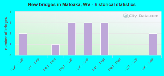
- New bridges - historical statistics
- 21900-1909
- 11920-1929
- 31930-1939
- 31940-1949
- 31950-1959
- 21980-1989

- Reconstructed bridges - Historical Statistics
- 21990-1999
- 22000-2009
- 02010-2019
- 12020-2022

- Bridge Condition - Deck
- 20.0%Good
- 30.0%Satisfactory
- 10.0%Fair
- 40.0%Poor

- Bridge Condition - Superstructure
- 10.0%Good
- 90.0%Fair

- Bridge Condition - Substructure
- 30.0%Satisfactory
- 40.0%Fair
- 30.0%Poor

- Bridge Condition - Channel
- 20.0%Very good
- 20.0%Good
- 60.0%Satisfactory
Find on map >> Show street view
Structure Number: 28A018, Location: 0.02 MI S OF CR 10/4 (Lat: 37.419111, Lng: -81.243500), Route carried "on" structure: State highway 1000, Year Built: 1948, Year Reconstructed: 2021, Status: Open, Structure Length: 1.80m (5.91ft), Average Daily Traffic: 2,500 (year 2018), Truck Traffic: 4%, Average Future Daily Traffic: 3,025 (year 2038), Features Intersected: WIDEMOUTH CREEK, Facility Carried by Structure: WV ROUTE 10
Minimum Vertical Clearance: 30+ m (98+ ft), Kilometerpoint: 10.879, Lanes on structure: 2, Owner: State Highway Agency, Approaching Roadway Width: 9.8m (32.2ft), Skew: 1 degrees, Material/Design: Steel, Design/Construction: Stringer/Multi-beam, Number Of Spans In Main Unit: 1, Length of Maximum Span: 16.9m (55.4ft), Curb or Sidewalk Widths: Left: 1.5m (4.9ft), Right: 1.5m (4.9ft), Curb-To-Curb Width: 10.3m (33.8ft), Out-to-Out Width: 13.7m (44.9ft)
Condition: Deck: Poor, Superstructure: Fair, Substructure: Fair, Channel: Satisfactory, Operating Rating: 88.0 metric tons, Method Used To Determine Operating Rating: Load and Resistance Factor (LRFR), Inventory Rating: 52.6 metric tons, Method Used To Determine Inventory Rating: Load and Resistance Factor (LRFR), Structural Evaluation: Somewhat better than minimum adequacy, Deck Geometry: Meets minimum limits, Waterway Adequacy: Equal to present minimum criteria, Approach Roadway Alignment: Better than present minimum criteria, Designated Inspection Frequency: Every 24 months, Inspection Date: March 2021, Deck Structure Type: Concrete Cast-file-Place, Wearing Surface/Protective System: Wearing Surface: Bituminous
Find on map >> Show street view
Structure Number: 28A019, Location: 0.01 MI N OF CR 10/11 (Lat: 37.417111, Lng: -81.244550), Route carried "on" structure: State highway 1000, Year Built: 1949, Year Reconstructed: 2021, Status: Open, Structure Length: 2.23m (7.32ft), Average Daily Traffic: 2,500 (year 2018), Truck Traffic: 4%, Average Future Daily Traffic: 3,025 (year 2038), Design Load: HS 15, Features Intersected: WIDEMOUTH CREEK, Facility Carried by Structure: WV ROUTE 10
Minimum Vertical Clearance: 30+ m (98+ ft), Kilometerpoint: 11.121, Lanes on structure: 2, Owner: State Highway Agency, Approaching Roadway Width: 10.4m (34.1ft), Skew: 4 degrees, Material/Design: Steel, Design/Construction: Stringer/Multi-beam, Number Of Spans In Main Unit: 1, Length of Maximum Span: 20.1m (65.9ft), Curb or Sidewalk Widths: Left: 0.5m (1.6ft), Right: 1.5m (4.9ft), Curb-To-Curb Width: 10.3m (33.8ft), Out-to-Out Width: 13.0m (42.7ft)
Condition: Deck: Poor, Superstructure: Fair, Substructure: Fair, Channel: Satisfactory, Operating Rating: 79.8 metric tons, Method Used To Determine Operating Rating: Load and Resistance Factor (LRFR), Inventory Rating: 61.7 metric tons, Method Used To Determine Inventory Rating: Load and Resistance Factor (LRFR), Structural Evaluation: Somewhat better than minimum adequacy, Deck Geometry: Meets minimum limits, Waterway Adequacy: Equal to present desirable criteria, Approach Roadway Alignment: Better than present minimum criteria, Length Of Structure Improvement: 2.23m (7.32ft), Designated Inspection Frequency: Every 24 months, Inspection Date: March 2021, Bridge Improvement Cost: $750,000, Roadway Improvement Cost: $250,000, Total Project Cost: $1,000,000 ( Estimate for 2019), Deck Structure Type: Concrete Cast-file-Place, Wearing Surface/Protective System: Wearing Surface: Bituminous
Find on map >> Show street view
Structure Number: 28A02, Location: 0.05 MI. S. OF CR. 10/15 (Lat: 37.420900, Lng: -81.253500), Route carried "on" structure: State highway 1000, Year Built: 1950, Status: Posted for load, Structure Length: 8.70m (28.54ft), Average Daily Traffic: 950 (year 2018), Truck Traffic: 4%, Average Future Daily Traffic: 1,150 (year 2038), Design Load: HS 15, Features Intersected: WIDEMOUTH CK.&NS RR, Facility Carried by Structure: WV ROUTE 10
Minimum Vertical Clearance: 30+ m (98+ ft), Kilometerpoint: 12.231, Lanes on structure: 2, Owner: State Highway Agency, Approaching Roadway Width: 8.5m (27.9ft), Material/Design: Steel continuous, Design/Construction: Stringer/Multi-beam, Number Of Spans In Main Unit: 1, Number Of Approach Spans: 2, Length of Maximum Span: 33.5m (109.9ft), Curb or Sidewalk Widths: Left: 0.9m (3.0ft), Right: 0.9m (3.0ft), Curb-To-Curb Width: 8.6m (28.2ft), Out-to-Out Width: 11.0m (36.1ft)
Condition: Deck: Poor, Superstructure: Fair, Substructure: Poor, Channel: Very good, Operating Rating: 55.3 metric tons, Method Used To Determine Operating Rating: Load Factor (LF), Inventory Rating: 33.6 metric tons, Method Used To Determine Inventory Rating: Load Factor (LF), Structural Evaluation: Meets minimum limits, Deck Geometry: Somewhat better than minimum adequacy, Underclear: Superior to present desirable criteria, Waterway Adequacy: Superior to present desirable criteria, Approach Roadway Alignment: Better than present minimum criteria, Length Of Structure Improvement: 8.70m (28.54ft), Designated Inspection Frequency: Every 24 months, Inspection Date: March 2020, Bridge Improvement Cost: $2,000,000, Roadway Improvement Cost: $200,000, Total Project Cost: $2,200,000 ( Estimate for 2018), Deck Structure Type: Concrete Cast-file-Place, Wearing Surface/Protective System: Wearing Surface: Bituminous
Find on map >> Show street view
Structure Number: 28A021, Location: 0.02 MI N OF CR 10/2 (Lat: 37.430611, Lng: -81.253189), Route carried "on" structure: State highway 1000, Year Built: 1952, Year Reconstructed: 2020, Status: Open, Structure Length: 6.92m (22.70ft), Average Daily Traffic: 700 (year 2019), Truck Traffic: 5%, Average Future Daily Traffic: 735 (year 2039), Design Load: HS 15, Features Intersected: RIGHTHAND FORK & NS RR, Facility Carried by Structure: WV RT 10
Minimum Vertical Clearance: 30+ m (98+ ft), Kilometerpoint: 13.551, Lanes on structure: 2, Owner: State Highway Agency, Approaching Roadway Width: 8.5m (27.9ft), Skew: 2 degrees, Material/Design: Steel continuous, Design/Construction: Stringer/Multi-beam, Number Of Spans In Main Unit: 1, Number Of Approach Spans: 2, Length of Maximum Span: 25.9m (85.0ft), Curb or Sidewalk Widths: Left: 1.5m (4.9ft), Right: 1.5m (4.9ft), Curb-To-Curb Width: 8.5m (27.9ft), Out-to-Out Width: 12.2m (40.0ft)
Condition: Deck: Satisfactory, Superstructure: Good, Substructure: Satisfactory, Channel: Very good, Operating Rating: 60.8 metric tons, Method Used To Determine Operating Rating: Load and Resistance Factor (LRFR), Inventory Rating: 47.2 metric tons, Method Used To Determine Inventory Rating: Load and Resistance Factor (LRFR), Structural Evaluation: Equal to present minimum criteria, Deck Geometry: Somewhat better than minimum adequacy, Waterway Adequacy: Superior to present desirable criteria, Approach Roadway Alignment: Better than present minimum criteria, Designated Inspection Frequency: Every 24 months, Inspection Date: October 2021, Deck Structure Type: Concrete Cast-file-Place
Find on map >> Show street view
Structure Number: 28A036, Location: 1.50 MI N OF CR 10/11 (Lat: 37.426911, Lng: -81.276511), Route carried "on" structure: County highway 1100, Year Built: 1985, Status: Open, Structure Length: 1.11m (3.64ft), Average Daily Traffic: 200 (year 2018), Truck Traffic: 2%, Average Future Daily Traffic: 242 (year 2038), Design Load: HS 20, Features Intersected: LEFTHAND FORK, Facility Carried by Structure: CR 11
Minimum Vertical Clearance: 30+ m (98+ ft), Kilometerpoint: 29.403, Lanes on structure: 2, Owner: State Highway Agency, Approaching Roadway Width: 6.1m (20.0ft), Skew: 5 degrees, Material/Design: Steel, Design/Construction: Stringer/Multi-beam, Number Of Spans In Main Unit: 1, Length of Maximum Span: 9.5m (31.2ft), Curb-To-Curb Width: 6.1m (20.0ft), Out-to-Out Width: 6.1m (20.0ft)
Condition: Deck: Fair, Superstructure: Fair, Substructure: Fair, Channel: Satisfactory, Operating Rating: 63.5 metric tons, Method Used To Determine Operating Rating: Load Factor (LF), Inventory Rating: 38.1 metric tons, Method Used To Determine Inventory Rating: Load Factor (LF), Structural Evaluation: Somewhat better than minimum adequacy, Deck Geometry: Meets minimum limits, Waterway Adequacy: Better than present minimum criteria, Approach Roadway Alignment: Equal to present minimum criteria, Length Of Structure Improvement: 1.11m (3.64ft), Designated Inspection Frequency: Every 24 months, Inspection Date: June 2020, Bridge Improvement Cost: $350,000, Roadway Improvement Cost: $50,000, Total Project Cost: $400,000 ( Estimate for 2018), Deck Structure Type: Wood or Timber, Wearing Surface/Protective System: Wearing Surface: Bituminous
Find on map >> Show street view
Structure Number: 28A154, Location: 0.20 MI.N. OF WV. 10 (Lat: 37.432569, Lng: -81.251819), Route carried "on" structure: County highway 1009, Year Built: 1980, Year Reconstructed: 2013, Status: Open, Structure Length: 1.23m (4.04ft), Average Daily Traffic: 10 (year 2018), Truck Traffic: 2%, Average Future Daily Traffic: 12 (year 2038), Features Intersected: RIGHTHAND FORK, Facility Carried by Structure: COUNTY ROUTE 10/9
Minimum Vertical Clearance: 30+ m (98+ ft), Kilometerpoint: 0.322, Lanes on structure: 1, Owner: State Highway Agency, Approaching Roadway Width: 3.0m (9.8ft), Material/Design: Steel, Design/Construction: Stringer/Multi-beam, Number Of Spans In Main Unit: 1, Length of Maximum Span: 11.7m (38.4ft), Curb or Sidewalk Widths: Left: 0.2m (0.7ft), Right: 0.2m (0.7ft), Curb-To-Curb Width: 3.9m (12.8ft), Out-to-Out Width: 4.3m (14.1ft)
Condition: Deck: Satisfactory, Superstructure: Fair, Substructure: Satisfactory, Channel: Satisfactory, Operating Rating: 60.8 metric tons, Method Used To Determine Operating Rating: Load Factor (LF), Inventory Rating: 36.3 metric tons, Method Used To Determine Inventory Rating: Load Factor (LF), Structural Evaluation: Somewhat better than minimum adequacy, Deck Geometry: Meets minimum limits, Waterway Adequacy: Better than present minimum criteria, Approach Roadway Alignment: Somewhat better than minimum adequacy, Designated Inspection Frequency: Every 24 months, Inspection Date: April 2020, Deck Structure Type: Wood or Timber
Find on map >> Show street view
Structure Number: 28A189, Location: 0.05 MILE EAST OF WV 10 (Lat: 37.417619, Lng: -81.244861), Route carried "on" structure: County highway 1025, Year Built: 1936, Year Reconstructed: 1997, Status: Posted for load, Structure Length: 1.25m (4.10ft), Average Daily Traffic: 100 (year 2019), Truck Traffic: 6%, Average Future Daily Traffic: 120 (year 2039), Features Intersected: RIGHTHAND FORK, Facility Carried by Structure: CO 10/25
Minimum Vertical Clearance: 30+ m (98+ ft), Kilometerpoint: 0.016, Lanes on structure: 1, Owner: State Highway Agency, Approaching Roadway Width: 3.7m (12.1ft), Material/Design: Steel, Design/Construction: Stringer/Multi-beam, Number Of Spans In Main Unit: 1, Length of Maximum Span: 11.7m (38.4ft), Curb or Sidewalk Widths: Left: 0.2m (0.7ft), Right: 0.2m (0.7ft), Curb-To-Curb Width: 4.5m (14.8ft), Out-to-Out Width: 4.9m (16.1ft)
Condition: Deck: Good, Superstructure: Fair, Substructure: Poor, Channel: Good, Operating Rating: 36.3 metric tons, Method Used To Determine Operating Rating: Load Factor (LF), Inventory Rating: 21.8 metric tons, Method Used To Determine Inventory Rating: Load Factor (LF), Structural Evaluation: Meets minimum limits, Deck Geometry: Equal to present minimum criteria, Waterway Adequacy: Equal to present minimum criteria, Approach Roadway Alignment: High priority of corrective action, Bridge Posting: Required (Relationship of Operating Rating to Maximum Legal Load: 20.0 - 29.9% below), Length Of Structure Improvement: 1.25m (4.10ft), Designated Inspection Frequency: Every 24 months, Other Special Inspection Frequency: Every 12 months, Inspection Date: August 2020, Other Special Inspection Date: August 2021, Bridge Improvement Cost: $500,000, Roadway Improvement Cost: $50,000, Total Project Cost: $550,000 ( Estimate for 2019), Deck Structure Type: Wood or Timber, Wearing Surface/Protective System: Wearing Surface: Bituminous
Find on map >> Show street view
Structure Number: 28A199, Location: 0.01 MI WEST OF WV 10 (Lat: 37.419800, Lng: -81.241731), Route carried "on" structure: County highway 1030, Year Built: 1936, Year Reconstructed: 2000, Status: Open, Structure Length: 1.21m (3.97ft), Average Daily Traffic: 30 (year 2019), Truck Traffic: 2%, Average Future Daily Traffic: 36 (year 2039), Features Intersected: RIGHT HAND FORK, Facility Carried by Structure: COUNTY ROUTE 10/30
Minimum Vertical Clearance: 30+ m (98+ ft), Kilometerpoint: 0.016, Lanes on structure: 1, Owner: State Highway Agency, Approaching Roadway Width: 6.1m (20.0ft), Material/Design: Steel, Design/Construction: Stringer/Multi-beam, Number Of Spans In Main Unit: 1, Length of Maximum Span: 11.3m (37.1ft), Curb or Sidewalk Widths: Left: 0.2m (0.7ft), Right: 0.2m (0.7ft), Curb-To-Curb Width: 3.3m (10.8ft), Out-to-Out Width: 3.6m (11.8ft)
Condition: Deck: Satisfactory, Superstructure: Fair, Substructure: Satisfactory, Channel: Satisfactory, Operating Rating: 53.5 metric tons, Method Used To Determine Operating Rating: Load Factor (LF), Inventory Rating: 31.7 metric tons, Method Used To Determine Inventory Rating: Load Factor (LF), Structural Evaluation: Somewhat better than minimum adequacy, Deck Geometry: High priority of replacement, Waterway Adequacy: Better than present minimum criteria, Approach Roadway Alignment: Meets minimum limits, Length Of Structure Improvement: 1.22m (4.00ft), Designated Inspection Frequency: Every 24 months, Inspection Date: May 2021, Bridge Improvement Cost: $400,000, Roadway Improvement Cost: $100,000, Total Project Cost: $500,000 ( Estimate for 2019), Deck Structure Type: Wood or Timber
Find on map >> Show street view
Structure Number: 28A315, Location: 0.10 MILE EAST OF WV 10 (Lat: 37.418950, Lng: -81.244281), Route carried "on" structure: County highway 1027, Year Built: 1936, Year Reconstructed: 1995, Status: Open, Structure Length: 1.11m (3.64ft), Average Daily Traffic: 40 (year 2018), Truck Traffic: 2%, Average Future Daily Traffic: 48 (year 2038), Features Intersected: RIGHTHAND FORK, Facility Carried by Structure: COUNTY ROUTE 10/27
Minimum Vertical Clearance: 30+ m (98+ ft), Kilometerpoint: 0.016, Lanes on structure: 1, Owner: State Highway Agency, Approaching Roadway Width: 10.4m (34.1ft), Skew: 1 degrees, Material/Design: Steel, Design/Construction: Stringer/Multi-beam, Number Of Spans In Main Unit: 1, Length of Maximum Span: 10.2m (33.5ft), Curb or Sidewalk Widths: Left: 0.2m (0.7ft), Right: 0.2m (0.7ft), Curb-To-Curb Width: 4.5m (14.8ft), Out-to-Out Width: 4.9m (16.1ft)
Condition: Deck: Good, Superstructure: Fair, Substructure: Fair, Channel: Good, Operating Rating: 72.6 metric tons, Method Used To Determine Operating Rating: Load Factor (LF), Inventory Rating: 43.5 metric tons, Method Used To Determine Inventory Rating: Load Factor (LF), Structural Evaluation: Somewhat better than minimum adequacy, Deck Geometry: Equal to present minimum criteria, Waterway Adequacy: Better than present minimum criteria, Approach Roadway Alignment: Meets minimum limits, Length Of Structure Improvement: 1.11m (3.64ft), Designated Inspection Frequency: Every 24 months, Inspection Date: July 2020, Bridge Improvement Cost: $325,000, Roadway Improvement Cost: $25,000, Total Project Cost: $350,000 ( Estimate for 2020), Deck Structure Type: Wood or Timber, Wearing Surface/Protective System: Wearing Surface: Bituminous
Find on map >> Show street view
Structure Number: 28A341, Location: 0.04 mile North of WV 10 (Lat: 37.424781, Lng: -81.255789), Route carried "on" structure: Other road 90121, Year Built: 1925, Status: Posted for load, Structure Length: 1.16m (3.81ft), Average Daily Traffic: 20 (year 2018), Truck Traffic: 5%, Average Future Daily Traffic: 24 (year 2038), Features Intersected: Right Fork Widemouth Cr., Facility Carried by Structure: HA 901/21
Minimum Vertical Clearance: 30+ m (98+ ft), Kilometerpoint: 0.064, Lanes on structure: 1, Owner: State Highway Agency, Approaching Roadway Width: 3.0m (9.8ft), Material/Design: Concrete, Design/Construction: Stringer/Multi-beam, Number Of Spans In Main Unit: 1, Length of Maximum Span: 11.1m (36.4ft), Curb-To-Curb Width: 4.2m (13.8ft), Out-to-Out Width: 5.5m (18.0ft)
Condition: Deck: Poor, Superstructure: Fair, Substructure: Poor, Channel: Satisfactory, Operating Rating: 47.2 metric tons, Method Used To Determine Operating Rating: Field evaluation and documented engineering judgment, Inventory Rating: 21.8 metric tons, Method Used To Determine Inventory Rating: Field evaluation and documented engineering judgment, Structural Evaluation: Meets minimum limits, Deck Geometry: Somewhat better than minimum adequacy, Waterway Adequacy: Equal to present desirable criteria, Approach Roadway Alignment: Meets minimum limits, Length Of Structure Improvement: 1.22m (4.00ft), Designated Inspection Frequency: Every 24 months, Inspection Date: September 2020, Bridge Improvement Cost: $350,000, Roadway Improvement Cost: $50,000, Total Project Cost: $400,000 ( Estimate for 2020), Deck Structure Type: Concrete Cast-file-Place, Wearing Surface/Protective System: Wearing Surface: Gravel
Find on map >> Show street view
Structure Number: 28A022, Location: 0.37 MI E OF CR 11/2 (Lat: 37.418069, Lng: -81.250011), Route carried "under" structure: County highway 1011, Year Built: 1945, Structure Length: 0. m, Average Daily Traffic: 250 (year 2019), Truck Traffic: 6%, Features Intersected: NS RAILWAY, Facility Carried by Structure: N S RAILWAY
Minimum Vertical Clearance: 3.91m (12.83ft), Kilometerpoint: 1.223, Lanes under structure: 1, Material/Design: Steel, Design/Construction: Stringer/Multi-beam, Length of Maximum Span: 15.9m (52.2ft)
Find on map >> Show street view
Structure Number: 28A023, Location: 0.14 MI S OF CR 10/3 (Lat: 37.419581, Lng: -81.255300), Route carried "under" structure: County highway 1015, Year Built: 1906, Structure Length: 0. m, Average Daily Traffic: 500 (year 2019), Truck Traffic: 6%, Features Intersected: NORFORK SOUTHERN RW, Facility Carried by Structure: N S RAILWAY
Minimum Vertical Clearance: 6.12m (20.08ft), Kilometerpoint: 0.290, Lanes under structure: 1, Length of Maximum Span: 17.9m (58.7ft)
Find on map >> Show street view
Structure Number: 28A034, Location: 0.27 MI N OF CR 10/11 (Lat: 37.415800, Lng: -81.264331), Route carried "under" structure: County highway 1100, Year Built: 1906, Structure Length: 0. m, Average Daily Traffic: 200 (year 2019), Truck Traffic: 9%, Features Intersected: NS RAILROAD, Facility Carried by Structure: NS RAILWAY
Minimum Vertical Clearance: 6.38m (20.93ft), Kilometerpoint: 27.423, Lanes under structure: 1, Material/Design: Steel, Design/Construction: Stringer/Multi-beam, Length of Maximum Span: 18.1m (59.4ft)
Find on map >> Show street view
Structure Number: 28A035, Location: 1.48 MI NOF CR 10/11 (Lat: 37.425931, Lng: -81.275700), Route carried "under" structure: County highway 1100, Year Built: 1950, Structure Length: 0. m, Average Daily Traffic: 200 (year 2019), Truck Traffic: 6%, Features Intersected: NS RAILWAY, Facility Carried by Structure: NS RAILWAY
Minimum Vertical Clearance: 4.04m (13.25ft), Kilometerpoint: 29.371, Lanes under structure: 1, Material/Design: Steel, Design/Construction: Girder and Floorbeam System, Length of Maximum Span: 17.7m (58.1ft)