Bridge Statistics for Meridian Station, Mississippi (MS)
Condition, Traffic, Stress, Structural Evaluation, Project Costs
- National Bridge Inventory (NBI) Statistics
- 31Number of bridges
- 233ft / 71.0mTotal length
- $519,592,000Total costs
- 20,828Total average daily traffic
- 2,116Total average daily truck traffic
- 27,882Total future (year 2037) average daily traffic
- National Bridge Inventory (NBI) Registered Bridges for Meridian Station
- No street view available for this location
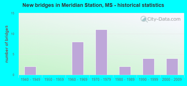
- New bridges - historical statistics
- 21940-1949
- 81960-1969
- 111970-1979
- 21980-1989
- 41990-1999
- 42000-2009

- Bridge Condition - Deck
- 60.9%Good
- 34.8%Satisfactory
- 4.3%Fair

- Bridge Condition - Superstructure
- 30.4%Very good
- 43.5%Good
- 21.7%Satisfactory
- 4.3%Fair

- Bridge Condition - Substructure
- 21.7%Very good
- 21.7%Good
- 43.5%Satisfactory
- 8.7%Fair
- 4.3%Poor

- Bridge Condition - Channel
- 25.8%Very good
- 22.6%Good
- 29.0%Satisfactory
- 9.7%Fair
- 12.9%Poor

- Bridge Condition - Culverts
- 50.0%Very good
- 37.5%Good
- 12.5%Satisfactory
Find on map >> Show street view
Structure Number: 1MS0119, Location: 0.1KM E. OF WHITAKER BLVD (Lat: 32.546106, Lng: -88.604742), Route carried "on" structure: Other road , Year Built: 1960, Status: Open, Structure Length: 0.73m (2.40ft), Average Daily Traffic: 1,000 (year 2015), Truck Traffic: 5%, Average Future Daily Traffic: 2,500 (year 2037), Design Load: H 15, Features Intersected: DRAINAGE DITCH, Facility Carried by Structure: ALLEN ROAD
Minimum Vertical Clearance: 30+ m (98+ ft), Kilometerpoint: 0.000, Lanes on structure: 2, Owner: Navy/Marines, Approaching Roadway Width: 6.6m (21.7ft), Skew: 3 degrees, Material/Design: Concrete, Design/Construction: Culvert, Number Of Spans In Main Unit: 2, Length of Maximum Span: 3.5m (11.5ft), Curb-To-Curb Width: 6.6m (21.7ft), Out-to-Out Width: 12.9m (42.3ft)
Condition: Channel: Satisfactory, Culverts: Satisfactory, Operating Rating: 32.7 metric tons, Method Used To Determine Operating Rating: Load Factor (LF), Inventory Rating: 19.6 metric tons, Method Used To Determine Inventory Rating: Load Factor (LF), Structural Evaluation: Somewhat better than minimum adequacy, Deck Geometry: High priority of corrective action, Waterway Adequacy: Equal to present minimum criteria, Approach Roadway Alignment: Equal to present desirable criteria, Length Of Structure Improvement: 0.73m (2.40ft), Designated Inspection Frequency: Every 24 months, Inspection Date: March 2021, Bridge Improvement Cost: $6,000, Roadway Improvement Cost: $2,000, Total Project Cost: $8,000 ( Estimate for 2021)
Find on map >> Show street view
Structure Number: 1MS0268, Location: 1.3KM E. OF WHITAKER BLVD (Lat: 32.546011, Lng: -88.615172), Route carried "on" structure: Other road , Year Built: 1960, Status: Open, Structure Length: 2.29m (7.51ft), Average Daily Traffic: 1,000 (year 2015), Truck Traffic: 5%, Average Future Daily Traffic: 2,500 (year 2037), Design Load: H 20, Features Intersected: WRIGHT'S CREEK, Facility Carried by Structure: ALLEN ROAD
Minimum Vertical Clearance: 30+ m (98+ ft), Kilometerpoint: 0.000, Lanes on structure: 2, Owner: Navy/Marines, Approaching Roadway Width: 6.9m (22.6ft), Material/Design: Concrete, Design/Construction: Channel Beam, Number Of Spans In Main Unit: 3, Length of Maximum Span: 7.6m (24.9ft), Curb or Sidewalk Widths: Left: 0.5m (1.6ft), Right: 0.5m (1.6ft), Curb-To-Curb Width: 8.5m (27.9ft), Out-to-Out Width: 9.6m (31.5ft)
Condition: Deck: Satisfactory, Superstructure: Satisfactory, Substructure: Satisfactory, Channel: Fair, Operating Rating: 53.2 metric tons, Method Used To Determine Operating Rating: Load Factor (LF), Inventory Rating: 32.0 metric tons, Method Used To Determine Inventory Rating: Load Factor (LF), Structural Evaluation: Equal to present minimum criteria, Deck Geometry: Somewhat better than minimum adequacy, Waterway Adequacy: Better than present minimum criteria, Approach Roadway Alignment: Equal to present desirable criteria, Length Of Structure Improvement: 2.29m (7.51ft), Designated Inspection Frequency: Every 24 months, Inspection Date: March 2021, Bridge Improvement Cost: $72,000, Roadway Improvement Cost: $31,000, Total Project Cost: $103,000 ( Estimate for 2021), Deck Structure Type: Concrete Precast Panels, Wearing Surface/Protective System: Wearing Surface: Bituminous
Find on map >> Show street view
Structure Number: 1MS0269, Location: 0.8KM WEST OF WHITAKER BL (Lat: 32.551567, Lng: -88.591892), Route carried "on" structure: Other road , Year Built: 1960, Status: Open, Structure Length: 2.29m (7.51ft), Average Daily Traffic: 1,000 (year 2015), Truck Traffic: 5%, Average Future Daily Traffic: 2,500 (year 2037), Design Load: H 20, Features Intersected: SEGAR'S CREEK, Facility Carried by Structure: FULLER ROAD
Minimum Vertical Clearance: 30+ m (98+ ft), Kilometerpoint: 0.000, Lanes on structure: 2, Owner: Navy/Marines, Approaching Roadway Width: 7.0m (23.0ft), Material/Design: Concrete, Design/Construction: Channel Beam, Number Of Spans In Main Unit: 3, Length of Maximum Span: 7.6m (24.9ft), Curb or Sidewalk Widths: Left: 0.5m (1.6ft), Right: 0.5m (1.6ft), Curb-To-Curb Width: 8.5m (27.9ft), Out-to-Out Width: 9.6m (31.5ft)
Condition: Deck: Fair, Superstructure: Satisfactory, Substructure: Satisfactory, Channel: Satisfactory, Operating Rating: 53.2 metric tons, Method Used To Determine Operating Rating: Load Factor (LF), Inventory Rating: 32.0 metric tons, Method Used To Determine Inventory Rating: Load Factor (LF), Structural Evaluation: Equal to present minimum criteria, Deck Geometry: Somewhat better than minimum adequacy, Waterway Adequacy: Better than present minimum criteria, Approach Roadway Alignment: Equal to present desirable criteria, Length Of Structure Improvement: 2.29m (7.51ft), Designated Inspection Frequency: Every 24 months, Inspection Date: March 2021, Bridge Improvement Cost: $55,000, Roadway Improvement Cost: $26,000, Total Project Cost: $81,000 ( Estimate for 2021), Deck Structure Type: Concrete Precast Panels, Wearing Surface/Protective System: Wearing Surface: Bituminous
Find on map >> Show street view
Structure Number: 31000390380116A, Location: 11.6 MI N I 59 (Lat: 32.529100, Lng: -88.654508), Route carried "on" structure: State highway 39, Year Built: 1976, Status: Open, Structure Length: 3.66m (12.01ft), Average Daily Traffic: 1,900 (year 2020), Truck Traffic: 14%, Average Future Daily Traffic: 1,900 (year 2040), Design Load: HS 20, Features Intersected: PONTA CREEK
Minimum Vertical Clearance: 30+ m (98+ ft), Kilometerpoint: 0.996, Lanes on structure: 2, Base Highway Network: Yes (Inventory Route: 3, Subroute: 1), Owner: State Highway Agency, Approaching Roadway Width: 13.4m (44.0ft), Material/Design: Prestressed concrete, Design/Construction: Stringer/Multi-beam, Number Of Spans In Main Unit: 3, Length of Maximum Span: 12.2m (40.0ft), Curb-To-Curb Width: 11.7m (38.4ft), Out-to-Out Width: 12.7m (41.7ft)
Condition: Deck: Good, Superstructure: Very good, Substructure: Very good, Channel: Very good, Operating Rating: 63.8 metric tons, Method Used To Determine Operating Rating: Load Factor (LF), Inventory Rating: 38.2 metric tons, Method Used To Determine Inventory Rating: Load Factor (LF), Structural Evaluation: Equal to present desirable criteria, Deck Geometry: Better than present minimum criteria, Waterway Adequacy: Equal to present desirable criteria, Approach Roadway Alignment: Equal to present desirable criteria, Designated Inspection Frequency: Every 24 months, Inspection Date: March 2021, Deck Structure Type: Concrete Cast-file-Place
Find on map >> Show street view
Structure Number: 31000390380116B, Location: 11.6 MI N I 59 (Lat: 32.528736, Lng: -88.654372), Route carried "on" structure: State highway 39, Year Built: 1976, Status: Open, Structure Length: 3.66m (12.01ft), Average Daily Traffic: 1,900 (year 2020), Truck Traffic: 14%, Average Future Daily Traffic: 1,900 (year 2040), Design Load: HS 20, Features Intersected: PONTA CREEK
Minimum Vertical Clearance: 30+ m (98+ ft), Kilometerpoint: 19.415, Lanes on structure: 2, Base Highway Network: Yes (Inventory Route: 3, Subroute: 1), Owner: State Highway Agency, Approaching Roadway Width: 13.4m (44.0ft), Material/Design: Prestressed concrete, Design/Construction: Stringer/Multi-beam, Number Of Spans In Main Unit: 3, Length of Maximum Span: 12.2m (40.0ft), Curb-To-Curb Width: 11.7m (38.4ft), Out-to-Out Width: 12.7m (41.7ft)
Condition: Deck: Good, Superstructure: Very good, Substructure: Good, Channel: Very good, Operating Rating: 63.8 metric tons, Method Used To Determine Operating Rating: Load Factor (LF), Inventory Rating: 38.2 metric tons, Method Used To Determine Inventory Rating: Load Factor (LF), Structural Evaluation: Better than present minimum criteria, Deck Geometry: Better than present minimum criteria, Waterway Adequacy: Equal to present desirable criteria, Approach Roadway Alignment: Equal to present desirable criteria, Designated Inspection Frequency: Every 24 months, Inspection Date: March 2021, Deck Structure Type: Concrete Cast-file-Place
Find on map >> Show street view
Structure Number: 31000390380118A, Location: 11.8 MI N I 59 (Lat: 32.531403, Lng: -88.654564), Route carried "on" structure: State highway 39, Year Built: 1976, Status: Open, Structure Length: 3.66m (12.01ft), Average Daily Traffic: 1,900 (year 2020), Truck Traffic: 14%, Average Future Daily Traffic: 1,900 (year 2040), Design Load: HS 20, Features Intersected: BAKER CREEK
Minimum Vertical Clearance: 30+ m (98+ ft), Kilometerpoint: 0.739, Lanes on structure: 2, Base Highway Network: Yes (Inventory Route: 3, Subroute: 1), Owner: State Highway Agency, Approaching Roadway Width: 13.4m (44.0ft), Material/Design: Prestressed concrete, Design/Construction: Stringer/Multi-beam, Number Of Spans In Main Unit: 3, Length of Maximum Span: 12.2m (40.0ft), Curb-To-Curb Width: 11.7m (38.4ft), Out-to-Out Width: 12.7m (41.7ft)
Condition: Deck: Good, Superstructure: Very good, Substructure: Good, Channel: Very good, Operating Rating: 63.8 metric tons, Method Used To Determine Operating Rating: Load Factor (LF), Inventory Rating: 38.2 metric tons, Method Used To Determine Inventory Rating: Load Factor (LF), Structural Evaluation: Better than present minimum criteria, Deck Geometry: Better than present minimum criteria, Waterway Adequacy: Equal to present desirable criteria, Approach Roadway Alignment: Equal to present desirable criteria, Designated Inspection Frequency: Every 24 months, Inspection Date: March 2021, Deck Structure Type: Concrete Cast-file-Place
Find on map >> Show street view
Structure Number: 31000390380118B, Location: 11.8 MI N I 59 (Lat: 32.531097, Lng: -88.654297), Route carried "on" structure: State highway 39, Year Built: 1976, Status: Open, Structure Length: 3.66m (12.01ft), Average Daily Traffic: 1,900 (year 2020), Truck Traffic: 14%, Average Future Daily Traffic: 1,900 (year 2040), Design Load: HS 20, Features Intersected: BAKER CREEK
Minimum Vertical Clearance: 30+ m (98+ ft), Kilometerpoint: 19.677, Lanes on structure: 2, Base Highway Network: Yes (Inventory Route: 3, Subroute: 1), Owner: State Highway Agency, Approaching Roadway Width: 13.4m (44.0ft), Material/Design: Prestressed concrete, Design/Construction: Stringer/Multi-beam, Number Of Spans In Main Unit: 3, Length of Maximum Span: 12.2m (40.0ft), Curb-To-Curb Width: 11.7m (38.4ft), Out-to-Out Width: 12.7m (41.7ft)
Condition: Deck: Good, Superstructure: Very good, Substructure: Good, Channel: Very good, Operating Rating: 63.8 metric tons, Method Used To Determine Operating Rating: Load Factor (LF), Inventory Rating: 38.2 metric tons, Method Used To Determine Inventory Rating: Load Factor (LF), Structural Evaluation: Better than present minimum criteria, Deck Geometry: Better than present minimum criteria, Waterway Adequacy: Equal to present desirable criteria, Approach Roadway Alignment: Equal to present desirable criteria, Designated Inspection Frequency: Every 24 months, Inspection Date: March 2021, Deck Structure Type: Concrete Cast-file-Place
Find on map >> Show street view
Structure Number: 31008540380023A, Location: 2.3 MI E SR 39 (Lat: 32.534692, Lng: -88.617658), Route carried "on" structure: State highway 854, Year Built: 1962, Status: Open, Structure Length: 0.73m (2.40ft), Average Daily Traffic: 800 (year 2020), Truck Traffic: 11%, Average Future Daily Traffic: 800 (year 2040), Design Load: HS 15, Features Intersected: WRIGHT CREEK TRIB
Minimum Vertical Clearance: 30+ m (98+ ft), Kilometerpoint: 1.709, Lanes on structure: 2, Owner: State Highway Agency, Approaching Roadway Width: 11.6m (38.1ft), Skew: 3 degrees, Material/Design: Concrete, Design/Construction: Culvert, Number Of Spans In Main Unit: 2, Length of Maximum Span: 3.5m (11.5ft)
Condition: Channel: Very good, Culverts: Very good, Inventory Rating: 76.2 metric tons, Method Used To Determine Inventory Rating: Load Factor (LF), Structural Evaluation: Equal to present desirable criteria, Waterway Adequacy: Better than present minimum criteria, Approach Roadway Alignment: Equal to present desirable criteria, Designated Inspection Frequency: Every 24 months, Inspection Date: March 2021
Find on map >> Show street view
Structure Number: 31008540380023B, Location: 2.3 MI E SR 39 (Lat: 32.534450, Lng: -88.617097), Route carried "on" structure: State highway 854, Year Built: 1978, Status: Open, Structure Length: 0.89m (2.92ft), Average Daily Traffic: 800 (year 2020), Truck Traffic: 11%, Average Future Daily Traffic: 800 (year 2040), Design Load: HS 15, Features Intersected: WRIGHT CREEK TRIB
Minimum Vertical Clearance: 30+ m (98+ ft), Kilometerpoint: 3.787, Lanes on structure: 2, Owner: State Highway Agency, Approaching Roadway Width: 11.6m (38.1ft), Skew: 4 degrees, Material/Design: Concrete, Design/Construction: Culvert, Number Of Spans In Main Unit: 2, Length of Maximum Span: 4.3m (14.1ft)
Condition: Channel: Very good, Culverts: Very good, Operating Rating: 96.1 metric tons, Method Used To Determine Operating Rating: Load Factor (LF), Inventory Rating: 57.5 metric tons, Method Used To Determine Inventory Rating: Load Factor (LF), Structural Evaluation: Equal to present desirable criteria, Waterway Adequacy: Better than present minimum criteria, Approach Roadway Alignment: Equal to present desirable criteria, Designated Inspection Frequency: Every 24 months, Inspection Date: March 2021
Find on map >> Show street view
Structure Number: 31008540380030A, Location: 3.0 MI E SR 39 (Lat: 32.541411, Lng: -88.609675), Route carried "on" structure: State highway 854, Year Built: 1962, Status: Open, Structure Length: 3.66m (12.01ft), Average Daily Traffic: 800 (year 2020), Truck Traffic: 11%, Average Future Daily Traffic: 800 (year 2040), Design Load: HS 20+Mod, Features Intersected: WRIGHT CREEK
Minimum Vertical Clearance: 30+ m (98+ ft), Kilometerpoint: 0.637, Lanes on structure: 2, Owner: State Highway Agency, Approaching Roadway Width: 11.9m (39.0ft), Material/Design: Prestressed concrete, Design/Construction: Stringer/Multi-beam, Number Of Spans In Main Unit: 3, Length of Maximum Span: 12.2m (40.0ft), Curb or Sidewalk Widths: Left: 0.3m (1.0ft), Right: 0.3m (1.0ft), Curb-To-Curb Width: 7.9m (25.9ft), Out-to-Out Width: 10.0m (32.8ft)
Condition: Deck: Satisfactory, Superstructure: Very good, Substructure: Very good, Channel: Very good, Operating Rating: 67.8 metric tons, Method Used To Determine Operating Rating: Load Factor (LF), Inventory Rating: 41.1 metric tons, Method Used To Determine Inventory Rating: Load Factor (LF), Structural Evaluation: Equal to present desirable criteria, Deck Geometry: High priority of replacement, Waterway Adequacy: Equal to present desirable criteria, Approach Roadway Alignment: Better than present minimum criteria, Length Of Structure Improvement: 4.50m (14.76ft), Designated Inspection Frequency: Every 24 months, Inspection Date: March 2021, Bridge Improvement Cost: $341,000,000, Roadway Improvement Cost: $34,000,000, Total Project Cost: $511,000,000, Deck Structure Type: Concrete Cast-file-Place, Wearing Surface/Protective System: Wearing Surface: Bituminous
Find on map >> Show street view
Structure Number: 31008540380030B, Location: 3.0 MI E SR 39 (Lat: 32.540175, Lng: -88.607197), Route carried "on" structure: State highway 854, Year Built: 1978, Status: Open, Structure Length: 3.66m (12.01ft), Average Daily Traffic: 800 (year 2020), Truck Traffic: 11%, Average Future Daily Traffic: 800 (year 2040), Design Load: HS 20, Features Intersected: WRIGHT CREEK
Minimum Vertical Clearance: 30+ m (98+ ft), Kilometerpoint: 4.946, Lanes on structure: 2, Owner: State Highway Agency, Approaching Roadway Width: 13.4m (44.0ft), Material/Design: Prestressed concrete continuous, Design/Construction: Stringer/Multi-beam, Number Of Spans In Main Unit: 3, Length of Maximum Span: 12.2m (40.0ft), Curb-To-Curb Width: 11.7m (38.4ft), Out-to-Out Width: 12.6m (41.3ft)
Condition: Deck: Good, Superstructure: Very good, Substructure: Very good, Channel: Very good, Operating Rating: 69.9 metric tons, Method Used To Determine Operating Rating: Load Factor (LF), Inventory Rating: 42.4 metric tons, Method Used To Determine Inventory Rating: Load Factor (LF), Structural Evaluation: Equal to present desirable criteria, Deck Geometry: Better than present minimum criteria, Waterway Adequacy: Equal to present desirable criteria, Approach Roadway Alignment: Equal to present minimum criteria, Designated Inspection Frequency: Every 24 months, Inspection Date: March 2021, Deck Structure Type: Concrete Cast-file-Place
Find on map >> Show street view
Structure Number: SA3500000000024, Location: SEC 25 T 9N R16E (Lat: 32.593556, Lng: -88.608572), Route carried "on" structure: County highway 159, Year Built: 1993, Status: Open, Structure Length: 1.16m (3.81ft), Average Daily Traffic: 100 (year 2019), Truck Traffic: 8%, Average Future Daily Traffic: 150 (year 2040), Design Load: H 15, Features Intersected: BIG REED CREEK, Facility Carried by Structure: ROSSIE COATS ROAD
Minimum Vertical Clearance: 30+ m (98+ ft), Kilometerpoint: 1.448, Lanes on structure: 2, Owner: County Highway Agency, Approaching Roadway Width: 7.6m (24.9ft), Material/Design: Concrete, Design/Construction: Channel Beam, Number Of Spans In Main Unit: 2, Length of Maximum Span: 5.8m (19.0ft), Curb-To-Curb Width: 7.1m (23.3ft), Out-to-Out Width: 7.6m (24.9ft)
Condition: Deck: Satisfactory, Superstructure: Good, Substructure: Satisfactory, Channel: Satisfactory, Operating Rating: 59.0 metric tons, Method Used To Determine Operating Rating: Load Factor (LF) rating reported by rating factor (RF) method using MS18 loading, Inventory Rating: 35.3 metric tons, Method Used To Determine Inventory Rating: Load Factor (LF) rating reported by rating factor (RF) method using MS18 loading, Structural Evaluation: Equal to present minimum criteria, Deck Geometry: Somewhat better than minimum adequacy, Waterway Adequacy: Equal to present minimum criteria, Approach Roadway Alignment: Somewhat better than minimum adequacy, Length Of Structure Improvement: 1.53m (5.02ft), Designated Inspection Frequency: Every 24 months, Inspection Date: May 2021, Bridge Improvement Cost: $300,000, Roadway Improvement Cost: $150,000, Total Project Cost: $450,000 ( Estimate for 2021), Deck Structure Type: Concrete Precast Panels, Wearing Surface/Protective System: Wearing Surface: Monolithic Concrete
Find on map >> Show street view
Structure Number: SA3800000000013, Location: SEC 13 T 8N R16E (Lat: 32.541667, Lng: -88.611083), Route carried "on" structure: County highway 1056, Year Built: 1980, Status: Open, Structure Length: 3.26m (10.70ft), Average Daily Traffic: 80 (year 2020), Truck Traffic: 5%, Average Future Daily Traffic: 120 (year 2041), Design Load: H 15, Features Intersected: WRIGHT CREEK, Facility Carried by Structure: SOULE CHAPEL ROAD
Minimum Vertical Clearance: 30+ m (98+ ft), Kilometerpoint: 0.804, Lanes on structure: 2, Owner: County Highway Agency, Approaching Roadway Width: 7.9m (25.9ft), Material/Design: Concrete, Design/Construction: Channel Beam, Number Of Spans In Main Unit: 5, Length of Maximum Span: 9.4m (30.8ft), Curb-To-Curb Width: 8.1m (26.6ft), Out-to-Out Width: 8.6m (28.2ft)
Condition: Deck: Good, Superstructure: Good, Substructure: Satisfactory, Channel: Satisfactory, Operating Rating: 53.5 metric tons, Method Used To Determine Operating Rating: Load Factor (LF) rating reported by rating factor (RF) method using MS18 loading, Inventory Rating: 32.1 metric tons, Method Used To Determine Inventory Rating: Load Factor (LF) rating reported by rating factor (RF) method using MS18 loading, Structural Evaluation: Equal to present minimum criteria, Deck Geometry: Equal to present minimum criteria, Waterway Adequacy: Better than present minimum criteria, Approach Roadway Alignment: Equal to present minimum criteria, Length Of Structure Improvement: 3.66m (12.01ft), Designated Inspection Frequency: Every 24 months, Inspection Date: Febuary 2021, Bridge Improvement Cost: $480,000, Roadway Improvement Cost: $150,000, Total Project Cost: $630,000 ( Estimate for 2021), Deck Structure Type: Concrete Precast Panels, Wearing Surface/Protective System: Wearing Surface: Monolithic Concrete
Find on map >> Show street view
Structure Number: SA3800000000017, Location: SEC 29 T 8N R17E B (Lat: 32.514722, Lng: -88.586806), Route carried "on" structure: County highway 1056, Year Built: 1993, Status: Open, Structure Length: 2.10m (6.89ft), Average Daily Traffic: 200 (year 2019), Truck Traffic: 8%, Average Future Daily Traffic: 300 (year 2040), Design Load: H 15, Features Intersected: LOST HORSE CREEK, Facility Carried by Structure: FRED CLAYTON RD
Minimum Vertical Clearance: 30+ m (98+ ft), Kilometerpoint: 0.965, Lanes on structure: 2, Owner: County Highway Agency, Approaching Roadway Width: 8.5m (27.9ft), Material/Design: Concrete, Design/Construction: Channel Beam, Number Of Spans In Main Unit: 3, Length of Maximum Span: 9.4m (30.8ft), Curb-To-Curb Width: 8.1m (26.6ft), Out-to-Out Width: 8.6m (28.2ft)
Condition: Deck: Good, Superstructure: Good, Substructure: Good, Channel: Satisfactory, Operating Rating: 53.5 metric tons, Method Used To Determine Operating Rating: Load Factor (LF) rating reported by rating factor (RF) method using MS18 loading, Inventory Rating: 32.1 metric tons, Method Used To Determine Inventory Rating: Load Factor (LF) rating reported by rating factor (RF) method using MS18 loading, Structural Evaluation: Better than present minimum criteria, Deck Geometry: Somewhat better than minimum adequacy, Waterway Adequacy: Equal to present desirable criteria, Approach Roadway Alignment: Equal to present desirable criteria, Length Of Structure Improvement: 2.84m (9.32ft), Designated Inspection Frequency: Every 24 months, Inspection Date: Febuary 2021, Bridge Improvement Cost: $400,000, Roadway Improvement Cost: $150,000, Total Project Cost: $550,000 ( Estimate for 2021), Deck Structure Type: Concrete Precast Panels, Wearing Surface/Protective System: Wearing Surface: Monolithic Concrete
Find on map >> Show street view
Structure Number: SA3800000000262, Location: SEC 3 T 8N R16E (Lat: 32.566375, Lng: -88.641403), Route carried "on" structure: County highway 1092, Year Built: 1975, Status: Open, Structure Length: 1.74m (5.71ft), Average Daily Traffic: 125 (year 2021), Truck Traffic: 10%, Average Future Daily Traffic: 175 (year 2041), Design Load: H 15, Features Intersected: CREEK, Facility Carried by Structure: CHARLIE JOHNSON RD
Minimum Vertical Clearance: 30+ m (98+ ft), Kilometerpoint: 0.482, Lanes on structure: 2, Owner: County Highway Agency, Approaching Roadway Width: 8.8m (28.9ft), Material/Design: Concrete, Design/Construction: Channel Beam, Number Of Spans In Main Unit: 3, Length of Maximum Span: 5.8m (19.0ft), Curb-To-Curb Width: 8.2m (26.9ft), Out-to-Out Width: 8.6m (28.2ft)
Condition: Deck: Satisfactory, Superstructure: Satisfactory, Substructure: Satisfactory, Channel: Good, Operating Rating: 59.4 metric tons, Method Used To Determine Operating Rating: Load Factor (LF), Inventory Rating: 35.6 metric tons, Method Used To Determine Inventory Rating: Load Factor (LF), Structural Evaluation: Equal to present minimum criteria, Deck Geometry: Somewhat better than minimum adequacy, Waterway Adequacy: Equal to present minimum criteria, Approach Roadway Alignment: Equal to present desirable criteria, Length Of Structure Improvement: 2.10m (6.89ft), Designated Inspection Frequency: Every 12 months, Inspection Date: August 2021, Bridge Improvement Cost: $300,000, Roadway Improvement Cost: $150,000, Total Project Cost: $450,000 ( Estimate for 2021), Deck Structure Type: Concrete Precast Panels, Wearing Surface/Protective System: Wearing Surface: Monolithic Concrete
Find on map >> Show street view
Structure Number: SA3800000000263, Location: SEC 3 T 8N R16E (Lat: 32.560236, Lng: -88.641381), Route carried "on" structure: County highway 1094, Year Built: 1976, Status: Open, Structure Length: 1.74m (5.71ft), Average Daily Traffic: 100 (year 2017), Average Future Daily Traffic: 150 (year 2040), Design Load: H 15, Features Intersected: MOSLEY BRANCH, Facility Carried by Structure: ANTIOCH ROAD
Minimum Vertical Clearance: 30+ m (98+ ft), Kilometerpoint: 0.965, Lanes on structure: 2, Owner: County Highway Agency, Approaching Roadway Width: 9.1m (29.9ft), Material/Design: Concrete, Design/Construction: Channel Beam, Number Of Spans In Main Unit: 3, Length of Maximum Span: 5.8m (19.0ft), Curb-To-Curb Width: 8.2m (26.9ft), Out-to-Out Width: 8.6m (28.2ft)
Condition: Deck: Satisfactory, Superstructure: Good, Substructure: Satisfactory, Channel: Good, Operating Rating: 59.0 metric tons, Method Used To Determine Operating Rating: Load Factor (LF) rating reported by rating factor (RF) method using MS18 loading, Inventory Rating: 35.3 metric tons, Method Used To Determine Inventory Rating: Load Factor (LF) rating reported by rating factor (RF) method using MS18 loading, Structural Evaluation: Equal to present minimum criteria, Deck Geometry: Equal to present minimum criteria, Waterway Adequacy: Better than present minimum criteria, Approach Roadway Alignment: Equal to present minimum criteria, Length Of Structure Improvement: 2.10m (6.89ft), Designated Inspection Frequency: Every 24 months, Inspection Date: August 2020, Bridge Improvement Cost: $170,000, Roadway Improvement Cost: $150,000, Total Project Cost: $320,000 ( Estimate for 2017), Deck Structure Type: Concrete Precast Panels, Wearing Surface/Protective System: Wearing Surface: Monolithic Concrete
Find on map >> Show street view
Structure Number: SA3800000000264, Location: SEC 3 T 8N R16E (Lat: 32.563233, Lng: -88.642886), Route carried "on" structure: County highway 1094, Year Built: 2009, Status: Open, Structure Length: 1.20m (3.94ft), Average Daily Traffic: 100 (year 2017), Average Future Daily Traffic: 150 (year 2038), Design Load: HS 20, Features Intersected: MOSLEY BRANCH, Facility Carried by Structure: ANTIOCH ROAD
Minimum Vertical Clearance: 30+ m (98+ ft), Kilometerpoint: 1.448, Lanes on structure: 2, Owner: County Highway Agency, Approaching Roadway Width: 6.7m (22.0ft), Skew: 1 degrees, Material/Design: Concrete, Design/Construction: Culvert, Number Of Spans In Main Unit: 2, Length of Maximum Span: 4.9m (16.1ft)
Condition: Channel: Satisfactory, Culverts: Very good, Operating Rating: 54.8 metric tons, Method Used To Determine Operating Rating: Load Factor (LF) rating reported by rating factor (RF) method using MS18 loading, Inventory Rating: 32.7 metric tons, Method Used To Determine Inventory Rating: Load Factor (LF) rating reported by rating factor (RF) method using MS18 loading, Structural Evaluation: Equal to present desirable criteria, Waterway Adequacy: Superior to present desirable criteria, Approach Roadway Alignment: Equal to present desirable criteria, Length Of Structure Improvement: 1.14m (3.74ft), Designated Inspection Frequency: Every 24 months, Inspection Date: March 2020, Bridge Improvement Cost: $150,000, Roadway Improvement Cost: $150,000, Total Project Cost: $300,000 ( Estimate for 2017)
Find on map >> Show street view
Structure Number: SA3800000000265, Location: SEC 4 T 8N R16E (Lat: 32.575972, Lng: -88.666139), Route carried "on" structure: County highway 1097, Year Built: 1974, Status: Posted for load, Structure Length: 1.74m (5.71ft), Average Daily Traffic: 90 (year 2020), Truck Traffic: 2%, Average Future Daily Traffic: 135 (year 2041), Design Load: HS 20, Features Intersected: MOSLEY CREEK, Facility Carried by Structure: KEMPDALE RD
Minimum Vertical Clearance: 30+ m (98+ ft), Kilometerpoint: 1.287, Lanes on structure: 2, Owner: County Highway Agency, Approaching Roadway Width: 8.5m (27.9ft), Material/Design: Concrete, Design/Construction: Channel Beam, Number Of Spans In Main Unit: 3, Length of Maximum Span: 5.8m (19.0ft), Curb-To-Curb Width: 8.2m (26.9ft), Out-to-Out Width: 8.6m (28.2ft)
Condition: Deck: Satisfactory, Superstructure: Satisfactory, Substructure: Satisfactory, Channel: Good, Operating Rating: 54.1 metric tons, Method Used To Determine Operating Rating: Load Factor (LF), Inventory Rating: 32.4 metric tons, Method Used To Determine Inventory Rating: Load Factor (LF), Structural Evaluation: Equal to present minimum criteria, Deck Geometry: Equal to present minimum criteria, Waterway Adequacy: Better than present minimum criteria, Approach Roadway Alignment: Equal to present minimum criteria, Length Of Structure Improvement: 2.10m (6.89ft), Designated Inspection Frequency: Every 12 months, Inspection Date: August 2021, Bridge Improvement Cost: $400,000, Roadway Improvement Cost: $150,000, Total Project Cost: $550,000 ( Estimate for 2021), Deck Structure Type: Concrete Precast Panels, Wearing Surface/Protective System: Wearing Surface: Monolithic Concrete
Find on map >> Show street view
Structure Number: SA3800000000267, Location: SEC 11 T 8N R16E (Lat: 32.555494, Lng: -88.628072), Route carried "on" structure: County highway 1093, Year Built: 1976, Status: Open, Structure Length: 2.32m (7.61ft), Average Daily Traffic: 110 (year 2017), Truck Traffic: 8%, Average Future Daily Traffic: 165 (year 2040), Design Load: H 15, Features Intersected: WRIGHT CREEK, Facility Carried by Structure: CHARLIE JOHNSON RD
Minimum Vertical Clearance: 30+ m (98+ ft), Kilometerpoint: 0.965, Lanes on structure: 2, Owner: County Highway Agency, Approaching Roadway Width: 8.8m (28.9ft), Material/Design: Concrete, Design/Construction: Channel Beam, Number Of Spans In Main Unit: 4, Length of Maximum Span: 5.8m (19.0ft), Curb-To-Curb Width: 8.1m (26.6ft), Out-to-Out Width: 8.6m (28.2ft)
Condition: Deck: Good, Superstructure: Good, Substructure: Fair, Channel: Good, Operating Rating: 59.0 metric tons, Method Used To Determine Operating Rating: Load Factor (LF) rating reported by rating factor (RF) method using MS18 loading, Inventory Rating: 35.3 metric tons, Method Used To Determine Inventory Rating: Load Factor (LF) rating reported by rating factor (RF) method using MS18 loading, Structural Evaluation: Somewhat better than minimum adequacy, Deck Geometry: Somewhat better than minimum adequacy, Waterway Adequacy: Better than present minimum criteria, Approach Roadway Alignment: Equal to present minimum criteria, Length Of Structure Improvement: 2.83m (9.28ft), Designated Inspection Frequency: Every 24 months, Inspection Date: August 2020, Bridge Improvement Cost: $210,000, Roadway Improvement Cost: $150,000, Total Project Cost: $360,000 ( Estimate for 2017), Deck Structure Type: Concrete Precast Panels, Wearing Surface/Protective System: Wearing Surface: Monolithic Concrete
Find on map >> Show street view
Structure Number: SA3800000000272, Location: SEC 13 T 8N R16E B (Lat: 32.533500, Lng: -88.614097), Route carried "on" structure: County highway 1056, Year Built: 2005, Status: Open, Structure Length: 2.10m (6.89ft), Average Daily Traffic: 570 (year 2017), Truck Traffic: 8%, Average Future Daily Traffic: 855 (year 2040), Design Load: HS 20, Features Intersected: PONTA CREEK, Facility Carried by Structure: CHIP PICKERING DR
Minimum Vertical Clearance: 30+ m (98+ ft), Kilometerpoint: 4.667, Lanes on structure: 2, Owner: County Highway Agency, Approaching Roadway Width: 7.9m (25.9ft), Material/Design: Concrete, Design/Construction: Channel Beam, Number Of Spans In Main Unit: 3, Length of Maximum Span: 9.4m (30.8ft), Curb-To-Curb Width: 8.6m (28.2ft), Out-to-Out Width: 9.4m (30.8ft)
Condition: Deck: Good, Superstructure: Satisfactory, Substructure: Very good, Channel: Good, Operating Rating: 62.5 metric tons, Method Used To Determine Operating Rating: Load Factor (LF) rating reported by rating factor (RF) method using MS18 loading, Inventory Rating: 37.6 metric tons, Method Used To Determine Inventory Rating: Load Factor (LF) rating reported by rating factor (RF) method using MS18 loading, Structural Evaluation: Equal to present minimum criteria, Deck Geometry: Somewhat better than minimum adequacy, Waterway Adequacy: Equal to present desirable criteria, Approach Roadway Alignment: Equal to present desirable criteria, Length Of Structure Improvement: 2.83m (9.28ft), Designated Inspection Frequency: Every 24 months, Inspection Date: August 2020, Bridge Improvement Cost: $200,000, Roadway Improvement Cost: $150,000, Total Project Cost: $350,000 ( Estimate for 2017), Deck Structure Type: Concrete Precast Panels, Wearing Surface/Protective System: Wearing Surface: Monolithic Concrete
Find on map >> Show street view
Structure Number: SA3800000000273, Location: SEC 16 T 8N R16E B (Lat: 32.537236, Lng: -88.663675), Route carried "on" structure: County highway 456, Year Built: 1993, Status: Open, Structure Length: 1.74m (5.71ft), Average Daily Traffic: 490 (year 2017), Truck Traffic: 8%, Average Future Daily Traffic: 735 (year 2040), Design Load: H 15, Features Intersected: BRANCH, Facility Carried by Structure: SUNSHINE RD
Minimum Vertical Clearance: 30+ m (98+ ft), Kilometerpoint: 11.426, Lanes on structure: 2, Owner: County Highway Agency, Approaching Roadway Width: 8.5m (27.9ft), Material/Design: Concrete, Design/Construction: Channel Beam, Number Of Spans In Main Unit: 3, Length of Maximum Span: 5.8m (19.0ft), Curb-To-Curb Width: 7.2m (23.6ft), Out-to-Out Width: 7.6m (24.9ft)
Condition: Deck: Satisfactory, Superstructure: Good, Substructure: Satisfactory, Channel: Satisfactory, Operating Rating: 59.0 metric tons, Method Used To Determine Operating Rating: Load Factor (LF) rating reported by rating factor (RF) method using MS18 loading, Inventory Rating: 35.3 metric tons, Method Used To Determine Inventory Rating: Load Factor (LF) rating reported by rating factor (RF) method using MS18 loading, Structural Evaluation: Equal to present minimum criteria, Deck Geometry: Meets minimum limits, Waterway Adequacy: Better than present minimum criteria, Approach Roadway Alignment: Meets minimum limits, Length Of Structure Improvement: 2.10m (6.89ft), Designated Inspection Frequency: Every 24 months, Inspection Date: April 2020, Bridge Improvement Cost: $300,000, Roadway Improvement Cost: $150,000, Total Project Cost: $450,000 ( Estimate for 2020), Deck Structure Type: Concrete Precast Panels, Wearing Surface/Protective System: Wearing Surface: Bituminous
Find on map >> Show street view
Structure Number: SA3800000000274, Location: SEC 16 T 8N R16E (Lat: 32.534006, Lng: -88.660950), Route carried "on" structure: County highway 1634, Year Built: 1946, Status: Posted for load, Structure Length: 3.05m (10.01ft), Average Daily Traffic: 243 (year 2021), Truck Traffic: 8%, Average Future Daily Traffic: 362 (year 2041), Design Load: H 15, Features Intersected: CREEK, Facility Carried by Structure: OLD HWY 39
Minimum Vertical Clearance: 30+ m (98+ ft), Kilometerpoint: 6.759, Lanes on structure: 2, Owner: County Highway Agency, Approaching Roadway Width: 7.0m (23.0ft), Material/Design: Steel, Design/Construction: Stringer/Multi-beam, Number Of Spans In Main Unit: 3, Length of Maximum Span: 12.2m (40.0ft), Curb or Sidewalk Widths: Left: 0.7m (2.3ft), Right: 0.7m (2.3ft), Curb-To-Curb Width: 7.9m (25.9ft), Out-to-Out Width: 9.3m (30.5ft)
Condition: Deck: Satisfactory, Superstructure: Fair, Substructure: Poor, Channel: Poor, Operating Rating: 36.2 metric tons, Method Used To Determine Operating Rating: Load Factor (LF), Inventory Rating: 21.9 metric tons, Method Used To Determine Inventory Rating: Load Factor (LF), Structural Evaluation: Meets minimum limits, Deck Geometry: Somewhat better than minimum adequacy, Waterway Adequacy: Better than present minimum criteria, Approach Roadway Alignment: Equal to present desirable criteria, Bridge Posting: Required (Relationship of Operating Rating to Maximum Legal Load: 0.1 - 9.9% below), Length Of Structure Improvement: 3.66m (12.01ft), Designated Inspection Frequency: Every 12 months, Inspection Date: October 2021, Bridge Improvement Cost: $360,000, Roadway Improvement Cost: $150,000, Total Project Cost: $510,000 ( Estimate for 2021), Deck Structure Type: Concrete Cast-file-Place, Wearing Surface/Protective System: Wearing Surface: Monolithic Concrete
Find on map >> Show street view
Structure Number: SA3800000000277, Location: SEC 21 T 8N R16E (Lat: 32.527375, Lng: -88.663569), Route carried "on" structure: County highway 1634, Year Built: 1946, Status: Open, Structure Length: 1.13m (3.71ft), Average Daily Traffic: 220 (year 2017), Truck Traffic: 8%, Average Future Daily Traffic: 330 (year 2038), Design Load: H 20, Features Intersected: PONTA CREEK, Facility Carried by Structure: OLD HWY 39-
Minimum Vertical Clearance: 30+ m (98+ ft), Kilometerpoint: 5.954, Lanes on structure: 2, Owner: County Highway Agency, Approaching Roadway Width: 9.8m (32.2ft), Material/Design: Concrete, Design/Construction: Culvert, Number Of Spans In Main Unit: 2, Length of Maximum Span: 5.5m (18.0ft), Curb-To-Curb Width: 11.0m (36.1ft), Out-to-Out Width: 11.5m (37.7ft)
Condition: Channel: Fair, Culverts: Good, Operating Rating: 63.5 metric tons, Method Used To Determine Operating Rating: Load Factor (LF) rating reported by rating factor (RF) method using MS18 loading, Inventory Rating: 37.9 metric tons, Method Used To Determine Inventory Rating: Load Factor (LF) rating reported by rating factor (RF) method using MS18 loading, Structural Evaluation: Better than present minimum criteria, Deck Geometry: Equal to present desirable criteria, Waterway Adequacy: Better than present minimum criteria, Approach Roadway Alignment: Equal to present desirable criteria, Length Of Structure Improvement: 1.22m (4.00ft), Designated Inspection Frequency: Every 24 months, Inspection Date: March 2020, Bridge Improvement Cost: $170,000, Roadway Improvement Cost: $150,000, Total Project Cost: $320,000 ( Estimate for 2017)
Find on map >> Show street view
Structure Number: SA3800000000279, Location: SEC 23 T 8N R16E B (Lat: 32.524583, Lng: -88.628528), Route carried "on" structure: County highway 1530, Year Built: 1989, Status: Open, Structure Length: 3.84m (12.60ft), Average Daily Traffic: 1,130 (year 2017), Truck Traffic: 8%, Average Future Daily Traffic: 1,695 (year 2040), Design Load: HS 20, Features Intersected: LIZELIA CREEK, Facility Carried by Structure: LIZELIA ROAD
Minimum Vertical Clearance: 30+ m (98+ ft), Kilometerpoint: 11.104, Lanes on structure: 2, Owner: County Highway Agency, Approaching Roadway Width: 9.1m (29.9ft), Material/Design: Concrete, Design/Construction: Channel Beam, Number Of Spans In Main Unit: 6, Length of Maximum Span: 9.4m (30.8ft), Curb-To-Curb Width: 9.1m (29.9ft), Out-to-Out Width: 10.0m (32.8ft)
Condition: Deck: Good, Superstructure: Good, Substructure: Good, Channel: Good, Operating Rating: 59.3 metric tons, Method Used To Determine Operating Rating: Load Factor (LF) rating reported by rating factor (RF) method using MS18 loading, Inventory Rating: 35.6 metric tons, Method Used To Determine Inventory Rating: Load Factor (LF) rating reported by rating factor (RF) method using MS18 loading, Structural Evaluation: Better than present minimum criteria, Deck Geometry: Somewhat better than minimum adequacy, Waterway Adequacy: Superior to present desirable criteria, Approach Roadway Alignment: Better than present minimum criteria, Length Of Structure Improvement: 4.27m (14.01ft), Designated Inspection Frequency: Every 24 months, Inspection Date: August 2020, Bridge Improvement Cost: $300,000, Roadway Improvement Cost: $150,000, Total Project Cost: $450,000 ( Estimate for 2017), Deck Structure Type: Concrete Precast Panels, Wearing Surface/Protective System: Wearing Surface: Monolithic Concrete
Find on map >> Show street view
Structure Number: SA380000000028, Location: SEC 24 T 8N R16E B (Lat: 32.528417, Lng: -88.607486), Route carried "on" structure: County highway 1056, Year Built: 2005, Status: Open, Structure Length: 3.65m (11.98ft), Average Daily Traffic: 580 (year 2017), Truck Traffic: 8%, Average Future Daily Traffic: 870 (year 2040), Design Load: HS 20, Features Intersected: PONTA CREEK, Facility Carried by Structure: CHIP PICKERING DR
Minimum Vertical Clearance: 30+ m (98+ ft), Kilometerpoint: 3.701, Lanes on structure: 2, Owner: County Highway Agency, Approaching Roadway Width: 8.5m (27.9ft), Material/Design: Prestressed concrete, Design/Construction: Stringer/Multi-beam, Number Of Spans In Main Unit: 3, Length of Maximum Span: 12.2m (40.0ft), Curb-To-Curb Width: 8.5m (27.9ft), Out-to-Out Width: 9.3m (30.5ft)
Condition: Deck: Good, Superstructure: Very good, Substructure: Very good, Channel: Good, Operating Rating: 58.3 metric tons, Method Used To Determine Operating Rating: Load Factor (LF) rating reported by rating factor (RF) method using MS18 loading, Inventory Rating: 33.7 metric tons, Method Used To Determine Inventory Rating: Load Factor (LF) rating reported by rating factor (RF) method using MS18 loading, Structural Evaluation: Equal to present desirable criteria, Deck Geometry: Somewhat better than minimum adequacy, Waterway Adequacy: Equal to present desirable criteria, Approach Roadway Alignment: Equal to present desirable criteria, Length Of Structure Improvement: 4.27m (14.01ft), Designated Inspection Frequency: Every 24 months, Inspection Date: August 2020, Bridge Improvement Cost: $300,000, Roadway Improvement Cost: $150,000, Total Project Cost: $450,000 ( Estimate for 2017), Deck Structure Type: Concrete Cast-file-Place, Wearing Surface/Protective System: Wearing Surface: Monolithic Concrete
Find on map >> Show street view
Structure Number: SA3800000000282, Location: SEC 36 T 8N R16E (Lat: 32.499500, Lng: -88.611889), Route carried "on" structure: County highway 1060, Year Built: 1977, Status: Open, Structure Length: 1.74m (5.71ft), Average Daily Traffic: 70 (year 2017), Truck Traffic: 10%, Average Future Daily Traffic: 105 (year 2040), Design Load: H 15, Features Intersected: WILDHORSE CREEK, Facility Carried by Structure: LOST HORSE ROAD
Minimum Vertical Clearance: 30+ m (98+ ft), Kilometerpoint: 2.896, Lanes on structure: 2, Owner: County Highway Agency, Approaching Roadway Width: 7.3m (24.0ft), Material/Design: Concrete, Design/Construction: Channel Beam, Number Of Spans In Main Unit: 3, Length of Maximum Span: 5.8m (19.0ft), Curb-To-Curb Width: 8.2m (26.9ft), Out-to-Out Width: 8.6m (28.2ft)
Condition: Deck: Good, Superstructure: Good, Substructure: Satisfactory, Channel: Satisfactory, Operating Rating: 59.0 metric tons, Method Used To Determine Operating Rating: Load Factor (LF) rating reported by rating factor (RF) method using MS18 loading, Inventory Rating: 35.3 metric tons, Method Used To Determine Inventory Rating: Load Factor (LF) rating reported by rating factor (RF) method using MS18 loading, Structural Evaluation: Equal to present minimum criteria, Deck Geometry: Equal to present minimum criteria, Waterway Adequacy: Equal to present minimum criteria, Approach Roadway Alignment: Meets minimum limits, Length Of Structure Improvement: 2.10m (6.89ft), Designated Inspection Frequency: Every 24 months, Inspection Date: August 2020, Bridge Improvement Cost: $170,000, Roadway Improvement Cost: $150,000, Total Project Cost: $320,000 ( Estimate for 2017), Deck Structure Type: Concrete Precast Panels, Wearing Surface/Protective System: Wearing Surface: Monolithic Concrete
Find on map >> Show street view
Structure Number: SA3800000000283, Location: SEC 7 T 8N R17E B (Lat: 32.545639, Lng: -88.604831), Route carried "on" structure: County highway 456, Year Built: 1962, Status: Open, Structure Length: 0.64m (2.10ft), Average Daily Traffic: 530 (year 2012), Truck Traffic: 8%, Average Future Daily Traffic: 795 (year 2038), Design Load: HS 20, Features Intersected: BRANCH, Facility Carried by Structure: RABBIT RD
Minimum Vertical Clearance: 30+ m (98+ ft), Kilometerpoint: 17.702, Lanes on structure: 2, Owner: County Highway Agency, Approaching Roadway Width: 9.1m (29.9ft), Material/Design: Concrete, Design/Construction: Culvert, Number Of Spans In Main Unit: 2, Length of Maximum Span: 3.0m (9.8ft), Curb-To-Curb Width: 11.7m (38.4ft), Out-to-Out Width: 12.2m (40.0ft)
Condition: Channel: Poor, Culverts: Good, Operating Rating: 58.3 metric tons, Method Used To Determine Operating Rating: Load Factor (LF) rating reported by rating factor (RF) method using MS18 loading, Inventory Rating: 35.0 metric tons, Method Used To Determine Inventory Rating: Load Factor (LF) rating reported by rating factor (RF) method using MS18 loading, Structural Evaluation: Better than present minimum criteria, Deck Geometry: Better than present minimum criteria, Waterway Adequacy: Better than present minimum criteria, Approach Roadway Alignment: Equal to present desirable criteria, Length Of Structure Improvement: 0.71m (2.33ft), Designated Inspection Frequency: Every 24 months, Inspection Date: March 2020, Bridge Improvement Cost: $120,000, Roadway Improvement Cost: $150,000, Total Project Cost: $270,000 ( Estimate for 2017)
Find on map >> Show street view
Structure Number: SA3800000000285, Location: SEC 17 T 8N R17E B (Lat: 32.540136, Lng: -88.580644), Route carried "on" structure: County highway 456, Year Built: 1965, Status: Open, Structure Length: 0.67m (2.20ft), Average Daily Traffic: 530 (year 2012), Truck Traffic: 8%, Average Future Daily Traffic: 795 (year 2038), Design Load: HS 20, Features Intersected: SEGARS CREEK, Facility Carried by Structure: RABBIT RD
Minimum Vertical Clearance: 30+ m (98+ ft), Kilometerpoint: 20.277, Lanes on structure: 2, Owner: County Highway Agency, Approaching Roadway Width: 9.1m (29.9ft), Material/Design: Concrete, Design/Construction: Culvert, Number Of Spans In Main Unit: 2, Length of Maximum Span: 3.0m (9.8ft), Curb-To-Curb Width: 9.1m (29.9ft), Out-to-Out Width: 9.6m (31.5ft)
Condition: Channel: Poor, Culverts: Good, Operating Rating: 54.1 metric tons, Method Used To Determine Operating Rating: Load Factor (LF) rating reported by rating factor (RF) method using MS18 loading, Inventory Rating: 32.4 metric tons, Method Used To Determine Inventory Rating: Load Factor (LF) rating reported by rating factor (RF) method using MS18 loading, Structural Evaluation: Better than present minimum criteria, Deck Geometry: Equal to present minimum criteria, Waterway Adequacy: Better than present minimum criteria, Approach Roadway Alignment: Equal to present minimum criteria, Length Of Structure Improvement: 0.72m (2.36ft), Designated Inspection Frequency: Every 24 months, Inspection Date: March 2020, Bridge Improvement Cost: $120,000, Roadway Improvement Cost: $150,000, Total Project Cost: $270,000 ( Estimate for 2017)
Find on map >> Show street view
Structure Number: SA3800000000286, Location: SEC 17 T 8N R17E B (Lat: 32.535847, Lng: -88.576167), Route carried "on" structure: County highway 456, Year Built: 1991, Status: Open, Structure Length: 3.84m (12.60ft), Average Daily Traffic: 530 (year 2017), Truck Traffic: 8%, Average Future Daily Traffic: 795 (year 2040), Design Load: H 15, Features Intersected: SEGARS CREEK, Facility Carried by Structure: RABBIT RD
Minimum Vertical Clearance: 30+ m (98+ ft), Kilometerpoint: 21.243, Lanes on structure: 2, Owner: County Highway Agency, Approaching Roadway Width: 9.1m (29.9ft), Material/Design: Concrete, Design/Construction: Channel Beam, Number Of Spans In Main Unit: 6, Length of Maximum Span: 9.4m (30.8ft), Curb-To-Curb Width: 7.2m (23.6ft), Out-to-Out Width: 7.6m (24.9ft)
Condition: Deck: Good, Superstructure: Good, Substructure: Satisfactory, Channel: Satisfactory, Operating Rating: 54.8 metric tons, Method Used To Determine Operating Rating: Load Factor (LF) rating reported by rating factor (RF) method using MS18 loading, Inventory Rating: 32.7 metric tons, Method Used To Determine Inventory Rating: Load Factor (LF) rating reported by rating factor (RF) method using MS18 loading, Structural Evaluation: Equal to present minimum criteria, Deck Geometry: Meets minimum limits, Waterway Adequacy: Better than present minimum criteria, Approach Roadway Alignment: Equal to present desirable criteria, Length Of Structure Improvement: 4.27m (14.01ft), Designated Inspection Frequency: Every 24 months, Inspection Date: August 2020, Bridge Improvement Cost: $340,000, Roadway Improvement Cost: $150,000, Total Project Cost: $490,000 ( Estimate for 2017), Deck Structure Type: Concrete Precast Panels, Wearing Surface/Protective System: Wearing Surface: Bituminous
Find on map >> Show street view
Structure Number: SA3800000000287, Location: SEC 20 T 8N R17E B (Lat: 32.518742, Lng: -88.578378), Route carried "on" structure: County highway 456, Year Built: 1965, Status: Open, Structure Length: 3.26m (10.70ft), Average Daily Traffic: 530 (year 2021), Truck Traffic: 8%, Average Future Daily Traffic: 795 (year 2041), Design Load: H 15, Features Intersected: HORSE CREEK, Facility Carried by Structure: RABBIT ROAD
Minimum Vertical Clearance: 30+ m (98+ ft), Kilometerpoint: 23.335, Lanes on structure: 2, Owner: County Highway Agency, Approaching Roadway Width: 7.1m (23.3ft), Skew: 3 degrees, Material/Design: Concrete, Design/Construction: Channel Beam, Number Of Spans In Main Unit: 5, Length of Maximum Span: 9.4m (30.8ft), Curb or Sidewalk Widths: Left: 0.2m (0.7ft), Right: 0.2m (0.7ft), Curb-To-Curb Width: 7.1m (23.3ft), Out-to-Out Width: 7.5m (24.6ft)
Condition: Deck: Good, Superstructure: Good, Substructure: Fair, Channel: Poor, Operating Rating: 37.5 metric tons, Method Used To Determine Operating Rating: Load Factor (LF), Inventory Rating: 22.5 metric tons, Method Used To Determine Inventory Rating: Load Factor (LF), Structural Evaluation: Somewhat better than minimum adequacy, Deck Geometry: Meets minimum limits, Waterway Adequacy: Better than present minimum criteria, Approach Roadway Alignment: Equal to present minimum criteria, Length Of Structure Improvement: 3.66m (12.01ft), Designated Inspection Frequency: Every 12 months, Inspection Date: October 2021, Bridge Improvement Cost: $360,000, Roadway Improvement Cost: $150,000, Total Project Cost: $510,000 ( Estimate for 2021), Deck Structure Type: Concrete Precast Panels, Wearing Surface/Protective System: Wearing Surface: Bituminous
Find on map >> Show street view
Structure Number: SA3800000000293, Location: SEC 30 T 8N R17E (Lat: 32.509581, Lng: -88.599558), Route carried "on" structure: County highway 1058, Year Built: 2004, Status: Open, Structure Length: 1.18m (3.87ft), Average Daily Traffic: 700 (year 2017), Truck Traffic: 10%, Average Future Daily Traffic: 105 (year 2040), Design Load: HS 20, Features Intersected: HORSE CREEK, Facility Carried by Structure: CHIP PICKERING DR
Minimum Vertical Clearance: 30+ m (98+ ft), Kilometerpoint: 1.770, Lanes on structure: 2, Owner: County Highway Agency, Approaching Roadway Width: 10.4m (34.1ft), Skew: 1 degrees, Material/Design: Concrete, Design/Construction: Culvert, Number Of Spans In Main Unit: 2, Length of Maximum Span: 5.9m (19.4ft)
Condition: Channel: Fair, Culverts: Very good, Operating Rating: 35.3 metric tons, Method Used To Determine Operating Rating: Load Factor (LF) rating reported by rating factor (RF) method using MS18 loading, Inventory Rating: 21.4 metric tons, Method Used To Determine Inventory Rating: Load Factor (LF) rating reported by rating factor (RF) method using MS18 loading, Structural Evaluation: Somewhat better than minimum adequacy, Waterway Adequacy: Superior to present desirable criteria, Approach Roadway Alignment: Equal to present desirable criteria, Length Of Structure Improvement: 1.24m (4.07ft), Designated Inspection Frequency: Every 24 months, Inspection Date: March 2020, Bridge Improvement Cost: $250,000, Roadway Improvement Cost: $150,000, Total Project Cost: $400,000 ( Estimate for 2017)