Bridge Statistics for Mississippi State, Mississippi (MS)
Condition, Traffic, Stress, Structural Evaluation, Project Costs
- National Bridge Inventory (NBI) Statistics
- 22Number of bridges
- 194ft / 59.3mTotal length
- $550,037,000Total costs
- 178,200Total average daily traffic
- 21,380Total average daily truck traffic
- National Bridge Inventory (NBI) Registered Bridges for Mississippi State
- No street view available for this location
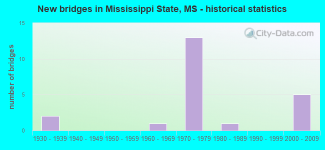
- New bridges - historical statistics
- 21930-1939
- 11960-1969
- 131970-1979
- 11980-1989
- 52000-2009


- Bridge Condition - Superstructure
- 55.6%Very good
- 44.4%Good

- Bridge Condition - Channel
- 20.0%Very good
- 40.0%Good
- 40.0%Satisfactory
Find on map >> Show street view
Structure Number: 2100082053152, Location: 0.5 MI W SR 182 (Lat: 33.476503, Lng: -88.768425), Route carried "on" structure: US 82, Year Built: 2004, Status: Open, Structure Length: 0.87m (2.85ft), Average Daily Traffic: 21,000 (year 2020), Truck Traffic: 13%, Average Future Daily Traffic: 27,000 (year 2040), Design Load: HS 20+Mod, Features Intersected: SAND CREEK TRIBUTARY
Minimum Vertical Clearance: 30+ m (98+ ft), Kilometerpoint: 31.184, Lanes on structure: 4, Base Highway Network: Yes (Inventory Route: 8, Subroute: 1), Owner: State Highway Agency, Approaching Roadway Width: 25.6m (84.0ft), Skew: 13 degrees, Material/Design: Concrete, Design/Construction: Culvert, Number Of Spans In Main Unit: 2, Length of Maximum Span: 3.7m (12.1ft)
Condition: Channel: Good, Culverts: Good, Operating Rating: 54.0 metric tons, Method Used To Determine Operating Rating: Load Factor (LF), Inventory Rating: 32.2 metric tons, Method Used To Determine Inventory Rating: Load Factor (LF), Structural Evaluation: Better than present minimum criteria, Waterway Adequacy: Equal to present minimum criteria, Approach Roadway Alignment: Equal to present desirable criteria, Designated Inspection Frequency: Every 24 months, Inspection Date: June 2020
Find on map >> Show street view
Structure Number: 21000820531523A, Location: 0.2 MI W US 82 (Lat: 33.471583, Lng: -88.763561), Route carried "on" structure: State highway 182, Year Built: 1967, Year Reconstructed: 2004, Status: Open, Structure Length: 3.66m (12.01ft), Average Daily Traffic: 7,000 (year 2020), Truck Traffic: 4%, Average Future Daily Traffic: 9,000 (year 2040), Design Load: HS 20, Features Intersected: SAND CREEK
Minimum Vertical Clearance: 30+ m (98+ ft), Kilometerpoint: 0.739, Lanes on structure: 3, Base Highway Network: Yes (Inventory Route: 18, Subroute: 1), Owner: State Highway Agency, Approaching Roadway Width: 16.5m (54.1ft), Skew: 10 degrees, Material/Design: Prestressed concrete, Design/Construction: Stringer/Multi-beam, Number Of Spans In Main Unit: 3, Length of Maximum Span: 12.2m (40.0ft), Curb or Sidewalk Widths: Left: 0.0m, Right: 0.5m (1.6ft), Curb-To-Curb Width: 14.8m (48.6ft), Out-to-Out Width: 15.6m (51.2ft)
Condition: Deck: Good, Superstructure: Good, Substructure: Good, Channel: Satisfactory, Operating Rating: 44.3 metric tons, Method Used To Determine Operating Rating: Load Factor (LF), Inventory Rating: 19.0 metric tons, Method Used To Determine Inventory Rating: Load Factor (LF), Structural Evaluation: Meets minimum limits, Deck Geometry: Equal to present minimum criteria, Waterway Adequacy: Superior to present desirable criteria, Approach Roadway Alignment: Equal to present desirable criteria, Length Of Structure Improvement: 3.66m (12.01ft), Designated Inspection Frequency: Every 24 months, Inspection Date: July 2020, Bridge Improvement Cost: $112,000,000, Roadway Improvement Cost: $130,000,000, Total Project Cost: $281,000,000, Deck Structure Type: Concrete Cast-file-Place
Find on map >> Show street view
Structure Number: 21000820531523B, Location: 0.2 MI W US 82 (Lat: 33.471211, Lng: -88.763747), Route carried "on" structure: State highway 82, Year Built: 1976, Status: Open, Structure Length: 3.66m (12.01ft), Average Daily Traffic: 7,000 (year 2020), Truck Traffic: 5%, Average Future Daily Traffic: 9,000 (year 2040), Design Load: HS 20, Features Intersected: SAND CREEK
Minimum Vertical Clearance: 30+ m (98+ ft), Kilometerpoint: 19.570, Lanes on structure: 3, Base Highway Network: Yes (Inventory Route: 18, Subroute: 1), Owner: State Highway Agency, Approaching Roadway Width: 12.2m (40.0ft), Skew: 10 degrees, Material/Design: Prestressed concrete, Design/Construction: Stringer/Multi-beam, Number Of Spans In Main Unit: 3, Length of Maximum Span: 12.2m (40.0ft), Curb-To-Curb Width: 14.8m (48.6ft), Out-to-Out Width: 15.8m (51.8ft)
Condition: Deck: Good, Superstructure: Very good, Substructure: Good, Channel: Satisfactory, Operating Rating: 61.1 metric tons, Method Used To Determine Operating Rating: Load Factor (LF), Inventory Rating: 37.0 metric tons, Method Used To Determine Inventory Rating: Load Factor (LF), Structural Evaluation: Better than present minimum criteria, Deck Geometry: Equal to present minimum criteria, Waterway Adequacy: Equal to present desirable criteria, Approach Roadway Alignment: Equal to present desirable criteria, Designated Inspection Frequency: Every 24 months, Inspection Date: July 2020, Deck Structure Type: Concrete Cast-file-Place
Find on map >> Show street view
Structure Number: 21000820531525A, Location: JCT SR 182& US 82 (Lat: 33.472144, Lng: -88.760550), Route carried "on" structure: US 82, Year Built: 1976, Status: Open, Structure Length: 11.30m (37.07ft), Average Daily Traffic: 10,500 (year 2020), Truck Traffic: 13%, Average Future Daily Traffic: 13,500 (year 2040), Design Load: HS 20, Features Intersected: SR 182
Minimum Vertical Clearance: 30+ m (98+ ft), Kilometerpoint: 9.191, Lanes on structure: 3, Lanes under structure: 4, Base Highway Network: Yes (Inventory Route: 8, Subroute: 1), Owner: State Highway Agency, Approaching Roadway Width: 13.4m (44.0ft), Skew: 3 degrees, Material/Design: Prestressed concrete, Design/Construction: Stringer/Multi-beam, Number Of Spans In Main Unit: 2, Number Of Approach Spans: 2, Length of Maximum Span: 33.2m (108.9ft), Curb-To-Curb Width: 14.8m (48.6ft), Out-to-Out Width: 15.8m (51.8ft)
Condition: Deck: Good, Superstructure: Good, Substructure: Good, Operating Rating: 45.2 metric tons, Method Used To Determine Operating Rating: Load Factor (LF), Inventory Rating: 17.2 metric tons, Method Used To Determine Inventory Rating: Load Factor (LF), Structural Evaluation: Meets minimum limits, Deck Geometry: Equal to present minimum criteria, Underclear: Better than present minimum criteria, Approach Roadway Alignment: Equal to present desirable criteria, Designated Inspection Frequency: Every 24 months, Inspection Date: June 2020, Deck Structure Type: Concrete Cast-file-Place
Find on map >> Show street view
Structure Number: 21000820531525B, Location: JCT SR 182 & US 82 (Lat: 33.472653, Lng: -88.761797), Route carried "on" structure: US 82, Year Built: 2004, Status: Open, Structure Length: 11.30m (37.07ft), Average Daily Traffic: 10,500 (year 2020), Truck Traffic: 13%, Average Future Daily Traffic: 13,500 (year 2040), Design Load: HS 20, Features Intersected: SR 182
Minimum Vertical Clearance: 30+ m (98+ ft), Kilometerpoint: 31.936, Lanes on structure: 2, Lanes under structure: 6, Base Highway Network: Yes (Inventory Route: 8, Subroute: 1), Owner: State Highway Agency, Approaching Roadway Width: 12.2m (40.0ft), Skew: 13 degrees, Material/Design: Prestressed concrete continuous, Design/Construction: Stringer/Multi-beam, Number Of Spans In Main Unit: 4, Length of Maximum Span: 33.2m (108.9ft), Curb-To-Curb Width: 12.2m (40.0ft), Out-to-Out Width: 13.0m (42.7ft)
Condition: Deck: Good, Superstructure: Good, Substructure: Good, Operating Rating: 65.3 metric tons, Method Used To Determine Operating Rating: Load Factor (LF), Inventory Rating: 34.7 metric tons, Method Used To Determine Inventory Rating: Load Factor (LF), Structural Evaluation: Better than present minimum criteria, Deck Geometry: Better than present minimum criteria, Underclear: Better than present minimum criteria, Approach Roadway Alignment: Equal to present desirable criteria, Designated Inspection Frequency: Every 24 months, Inspection Date: June 2020, Deck Structure Type: Concrete Cast-file-Place
Find on map >> Show street view
Structure Number: 21000820531530A, Location: 0.5 MI E SR 182 (Lat: 33.469336, Lng: -88.754147), Route carried "on" structure: US 82, Year Built: 1976, Status: Open, Structure Length: 5.14m (16.86ft), Average Daily Traffic: 10,000 (year 2020), Truck Traffic: 14%, Average Future Daily Traffic: 11,500 (year 2040), Design Load: HS 20, Features Intersected: COUNTY RD
Minimum Vertical Clearance: 30+ m (98+ ft), Kilometerpoint: 8.507, Lanes on structure: 2, Lanes under structure: 2, Base Highway Network: Yes (Inventory Route: 8, Subroute: 1), Owner: State Highway Agency, Approaching Roadway Width: 13.4m (44.0ft), Skew: 10 degrees, Material/Design: Prestressed concrete, Design/Construction: Stringer/Multi-beam, Number Of Spans In Main Unit: 1, Number Of Approach Spans: 2, Length of Maximum Span: 26.9m (88.3ft), Curb-To-Curb Width: 11.7m (38.4ft), Out-to-Out Width: 12.7m (41.7ft)
Condition: Deck: Good, Superstructure: Very good, Substructure: Good, Operating Rating: 60.8 metric tons, Method Used To Determine Operating Rating: Load Factor (LF), Inventory Rating: 32.5 metric tons, Method Used To Determine Inventory Rating: Load Factor (LF), Structural Evaluation: Better than present minimum criteria, Deck Geometry: Better than present minimum criteria, Underclear: Better than present minimum criteria, Approach Roadway Alignment: Equal to present desirable criteria, Designated Inspection Frequency: Every 24 months, Inspection Date: June 2020, Deck Structure Type: Concrete Cast-file-Place
Find on map >> Show street view
Structure Number: 21000820531530B, Location: 0.5 MI E SR 182 (Lat: 33.469128, Lng: -88.754672), Route carried "on" structure: US 82, Year Built: 1976, Status: Open, Structure Length: 5.15m (16.90ft), Average Daily Traffic: 10,000 (year 2020), Truck Traffic: 14%, Average Future Daily Traffic: 13,000 (year 2040), Design Load: HS 20, Features Intersected: COUNTY RD
Minimum Vertical Clearance: 30+ m (98+ ft), Kilometerpoint: 32.712, Lanes on structure: 2, Lanes under structure: 2, Base Highway Network: Yes (Inventory Route: 8, Subroute: 1), Owner: State Highway Agency, Approaching Roadway Width: 13.4m (44.0ft), Skew: 10 degrees, Material/Design: Prestressed concrete, Design/Construction: Stringer/Multi-beam, Number Of Spans In Main Unit: 1, Number Of Approach Spans: 2, Length of Maximum Span: 26.9m (88.3ft), Curb-To-Curb Width: 11.7m (38.4ft), Out-to-Out Width: 12.7m (41.7ft)
Condition: Deck: Good, Superstructure: Very good, Substructure: Good, Operating Rating: 60.6 metric tons, Method Used To Determine Operating Rating: Load Factor (LF), Inventory Rating: 32.4 metric tons, Method Used To Determine Inventory Rating: Load Factor (LF), Structural Evaluation: Better than present minimum criteria, Deck Geometry: Better than present minimum criteria, Underclear: Superior to present desirable criteria, Approach Roadway Alignment: Equal to present desirable criteria, Designated Inspection Frequency: Every 24 months, Inspection Date: June 2020, Deck Structure Type: Concrete Cast-file-Place
Find on map >> Show street view
Structure Number: 21000820531533, Location: 4.8 MI W LOWNDES CL (Lat: 33.468972, Lng: -88.749803), Route carried "on" structure: US 82, Year Built: 1976, Status: Open, Structure Length: 0.87m (2.85ft), Average Daily Traffic: 20,000 (year 2020), Truck Traffic: 14%, Average Future Daily Traffic: 26,000 (year 2040), Design Load: HS 20, Features Intersected: SAND CREEK TRIB
Minimum Vertical Clearance: 30+ m (98+ ft), Kilometerpoint: 33.165, Lanes on structure: 4, Base Highway Network: Yes (Inventory Route: 8, Subroute: 1), Owner: State Highway Agency, Approaching Roadway Width: 26.8m (87.9ft), Skew: 13 degrees, Material/Design: Concrete, Design/Construction: Culvert, Number Of Spans In Main Unit: 2, Length of Maximum Span: 3.7m (12.1ft)
Condition: Channel: Very good, Culverts: Good, Inventory Rating: 63.0 metric tons, Method Used To Determine Inventory Rating: Load Factor (LF), Structural Evaluation: Better than present minimum criteria, Waterway Adequacy: Superior to present desirable criteria, Approach Roadway Alignment: Equal to present desirable criteria, Designated Inspection Frequency: Every 24 months, Inspection Date: June 2020
Find on map >> Show street view
Structure Number: 21000820531543, Location: 3.8 MI W LOWDES CL (Lat: 33.469431, Lng: -88.732739), Route carried "on" structure: US 82, Year Built: 1976, Status: Open, Structure Length: 0.65m (2.13ft), Average Daily Traffic: 20,000 (year 2020), Truck Traffic: 14%, Average Future Daily Traffic: 23,000 (year 2040), Design Load: HS 20, Features Intersected: SAND CREEK TRIB
Minimum Vertical Clearance: 30+ m (98+ ft), Kilometerpoint: 34.765, Lanes on structure: 4, Base Highway Network: Yes (Inventory Route: 8, Subroute: 1), Owner: State Highway Agency, Approaching Roadway Width: 26.8m (87.9ft), Skew: 11 degrees, Material/Design: Concrete, Design/Construction: Culvert, Number Of Spans In Main Unit: 2, Length of Maximum Span: 3.0m (9.8ft)
Condition: Channel: Good, Culverts: Good, Inventory Rating: 72.9 metric tons, Method Used To Determine Inventory Rating: Load Factor (LF), Structural Evaluation: Better than present minimum criteria, Waterway Adequacy: Equal to present desirable criteria, Approach Roadway Alignment: Equal to present desirable criteria, Designated Inspection Frequency: Every 24 months, Inspection Date: June 2020
Find on map >> Show street view
Structure Number: 21000820531550A, Location: 3.1 MI W LOWNDES CL (Lat: 33.477469, Lng: -88.724950), Route carried "on" structure: US 82, Year Built: 1976, Status: Open, Structure Length: 6.20m (20.34ft), Average Daily Traffic: 10,000 (year 2020), Truck Traffic: 14%, Average Future Daily Traffic: 11,500 (year 2040), Design Load: HS 20, Features Intersected: SR 182
Minimum Vertical Clearance: 4.85m (15.91ft), Kilometerpoint: 5.340, Lanes on structure: 2, Lanes under structure: 4, Base Highway Network: Yes (Inventory Route: 8, Subroute: 1), Owner: State Highway Agency, Approaching Roadway Width: 13.4m (44.0ft), Skew: 12 degrees, Material/Design: Prestressed concrete, Design/Construction: Stringer/Multi-beam, Number Of Spans In Main Unit: 1, Number Of Approach Spans: 2, Length of Maximum Span: 29.3m (96.1ft), Curb-To-Curb Width: 11.7m (38.4ft), Out-to-Out Width: 12.7m (41.7ft)
Condition: Deck: Good, Superstructure: Very good, Substructure: Good, Operating Rating: 53.1 metric tons, Method Used To Determine Operating Rating: Load Factor (LF), Inventory Rating: 31.7 metric tons, Method Used To Determine Inventory Rating: Load Factor (LF), Structural Evaluation: Better than present minimum criteria, Deck Geometry: Better than present minimum criteria, Underclear: Better than present minimum criteria, Approach Roadway Alignment: Equal to present desirable criteria, Designated Inspection Frequency: Every 24 months, Inspection Date: June 2020, Deck Structure Type: Concrete Cast-file-Place
Find on map >> Show street view
Structure Number: 21000820531550B, Location: 3.1 MI W LOWNDES CL (Lat: 33.476958, Lng: -88.724897), Route carried "on" structure: US 82, Year Built: 1976, Status: Open, Structure Length: 6.20m (20.34ft), Average Daily Traffic: 10,000 (year 2020), Truck Traffic: 14%, Average Future Daily Traffic: 11,500 (year 2040), Design Load: HS 20, Features Intersected: SR 182
Minimum Vertical Clearance: 30+ m (98+ ft), Kilometerpoint: 35.911, Lanes on structure: 2, Lanes under structure: 4, Base Highway Network: Yes (Inventory Route: 8, Subroute: 1), Owner: State Highway Agency, Approaching Roadway Width: 13.4m (44.0ft), Skew: 12 degrees, Material/Design: Prestressed concrete, Design/Construction: Stringer/Multi-beam, Number Of Spans In Main Unit: 1, Number Of Approach Spans: 2, Length of Maximum Span: 29.3m (96.1ft), Curb-To-Curb Width: 11.7m (38.4ft), Out-to-Out Width: 12.7m (41.7ft)
Condition: Deck: Good, Superstructure: Very good, Substructure: Good, Operating Rating: 53.1 metric tons, Method Used To Determine Operating Rating: Load Factor (LF), Inventory Rating: 31.7 metric tons, Method Used To Determine Inventory Rating: Load Factor (LF), Structural Evaluation: Better than present minimum criteria, Deck Geometry: Better than present minimum criteria, Underclear: Better than present minimum criteria, Approach Roadway Alignment: Equal to present desirable criteria, Designated Inspection Frequency: Every 24 months, Inspection Date: June 2020, Deck Structure Type: Concrete Cast-file-Place
Find on map >> Show street view
Structure Number: 31001820530006, Location: 0.6 MI E JCT SR182 & US82 (Lat: 33.475703, Lng: -88.752297), Route carried "on" structure: State highway 182, Year Built: 1935, Status: Open, Structure Length: 0.61m (2.00ft), Average Daily Traffic: 1,500 (year 2020), Truck Traffic: 11%, Average Future Daily Traffic: 1,500 (year 2040), Design Load: H 15, Features Intersected: SAND CREEK TRIB
Minimum Vertical Clearance: 30+ m (98+ ft), Kilometerpoint: 20.748, Lanes on structure: 2, Owner: State Highway Agency, Approaching Roadway Width: 9.8m (32.2ft), Material/Design: Concrete, Design/Construction: Culvert, Number Of Spans In Main Unit: 1, Length of Maximum Span: 6.1m (20.0ft)
Condition: Channel: Satisfactory, Culverts: Good, Operating Rating: 34.0 metric tons, Method Used To Determine Operating Rating: Load Factor (LF), Inventory Rating: 20.4 metric tons, Method Used To Determine Inventory Rating: Load Factor (LF), Structural Evaluation: Somewhat better than minimum adequacy, Waterway Adequacy: Equal to present minimum criteria, Approach Roadway Alignment: Equal to present desirable criteria, Designated Inspection Frequency: Every 24 months, Inspection Date: June 2020
Find on map >> Show street view
Structure Number: 31001820530011, Location: 1.1 MI E JCT SR182 & US82 (Lat: 33.477075, Lng: -88.742458), Route carried "on" structure: State highway 182, Year Built: 1935, Status: Open, Structure Length: 0.67m (2.20ft), Average Daily Traffic: 1,500 (year 2020), Truck Traffic: 11%, Average Future Daily Traffic: 1,500 (year 2040), Design Load: H 15, Features Intersected: SAND CREEK TRIB
Minimum Vertical Clearance: 30+ m (98+ ft), Kilometerpoint: 21.684, Lanes on structure: 2, Owner: State Highway Agency, Approaching Roadway Width: 7.3m (24.0ft), Material/Design: Concrete, Design/Construction: Culvert, Number Of Spans In Main Unit: 1, Length of Maximum Span: 6.7m (22.0ft), Curb or Sidewalk Widths: Left: 0.2m (0.7ft), Right: 0.2m (0.7ft), Curb-To-Curb Width: 7.3m (24.0ft), Out-to-Out Width: 8.4m (27.6ft)
Condition: Channel: Good, Culverts: Good, Operating Rating: 49.2 metric tons, Method Used To Determine Operating Rating: Load Factor (LF), Inventory Rating: 29.5 metric tons, Method Used To Determine Inventory Rating: Load Factor (LF), Structural Evaluation: Better than present minimum criteria, Deck Geometry: Meets minimum limits, Waterway Adequacy: Equal to present minimum criteria, Approach Roadway Alignment: Equal to present desirable criteria, Length Of Structure Improvement: 1.34m (4.40ft), Designated Inspection Frequency: Every 24 months, Inspection Date: June 2020, Bridge Improvement Cost: $85,000,000, Roadway Improvement Cost: $9,000,000, Total Project Cost: $269,000,000
Find on map >> Show street view
Structure Number: SA5300000000097, Location: SEC 16 T18N R15E B (Lat: 33.425556, Lng: -88.736667), Route carried "on" structure: County highway 735, Year Built: 1979, Status: Open, Structure Length: 0.79m (2.59ft), Average Daily Traffic: 1,600 (year 2012), Truck Traffic: 8%, Average Future Daily Traffic: 2,400 (year 2032), Design Load: HS 20, Features Intersected: BCH OF CATALPA CREEK, Facility Carried by Structure: ARTESIA ROAD
Minimum Vertical Clearance: 30+ m (98+ ft), Kilometerpoint: 3.540, Lanes on structure: 2, Owner: County Highway Agency, Approaching Roadway Width: 9.1m (29.9ft), Skew: 3 degrees, Material/Design: Concrete, Design/Construction: Culvert, Number Of Spans In Main Unit: 1, Length of Maximum Span: 6.1m (20.0ft)
Condition: Channel: Very good, Culverts: Good, Operating Rating: 43.2 metric tons, Method Used To Determine Operating Rating: Allowable Stress (AS), Inventory Rating: 32.4 metric tons, Method Used To Determine Inventory Rating: Allowable Stress (AS), Structural Evaluation: Better than present minimum criteria, Waterway Adequacy: Equal to present desirable criteria, Approach Roadway Alignment: Equal to present desirable criteria, Designated Inspection Frequency: Every 24 months, Inspection Date: November 2019
Find on map >> Show street view
Structure Number: SA5300000000149, Location: SEC 20 T19N R15E (Lat: 33.497972, Lng: -88.748639), Route carried "on" structure: County highway 39, Year Built: 2000, Status: Open, Structure Length: 0.66m (2.17ft), Average Daily Traffic: 100 (year 2012), Average Future Daily Traffic: 150 (year 2032), Design Load: HS 20, Features Intersected: SAND CREEK, Facility Carried by Structure: PAT STATION ROAD
Minimum Vertical Clearance: 30+ m (98+ ft), Kilometerpoint: 0.804, Lanes on structure: 2, Owner: County Highway Agency, Approaching Roadway Width: 9.1m (29.9ft), Material/Design: Concrete, Design/Construction: Culvert, Number Of Spans In Main Unit: 2, Length of Maximum Span: 3.0m (9.8ft)
Condition: Channel: Good, Culverts: Good, Operating Rating: 43.2 metric tons, Method Used To Determine Operating Rating: Allowable Stress (AS), Inventory Rating: 32.4 metric tons, Method Used To Determine Inventory Rating: Allowable Stress (AS), Structural Evaluation: Better than present minimum criteria, Waterway Adequacy: Better than present minimum criteria, Approach Roadway Alignment: Equal to present desirable criteria, Designated Inspection Frequency: Every 24 months, Inspection Date: January 2020
Find on map >> Show street view
Structure Number: SA530000000015, Location: SEC 20 T19N R15E (Lat: 33.494028, Lng: -88.757500), Route carried "on" structure: County highway 39, Year Built: 1988, Status: Open, Structure Length: 1.52m (4.99ft), Average Daily Traffic: 100 (year 2012), Average Future Daily Traffic: 150 (year 2032), Design Load: H 15, Features Intersected: BCH OF SAND CREEK, Facility Carried by Structure: PAT STATION ROAD
Minimum Vertical Clearance: 30+ m (98+ ft), Kilometerpoint: 1.770, Lanes on structure: 2, Owner: County Highway Agency, Approaching Roadway Width: 6.1m (20.0ft), Material/Design: Concrete, Design/Construction: Channel Beam, Number Of Spans In Main Unit: 2, Length of Maximum Span: 9.4m (30.8ft), Curb or Sidewalk Widths: Left: 0.2m (0.7ft), Right: 0.2m (0.7ft), Curb-To-Curb Width: 8.2m (26.9ft), Out-to-Out Width: 8.7m (28.5ft)
Condition: Deck: Good, Superstructure: Good, Substructure: Good, Channel: Satisfactory, Operating Rating: 32.4 metric tons, Method Used To Determine Operating Rating: Allowable Stress (AS), Inventory Rating: 17.1 metric tons, Method Used To Determine Inventory Rating: Allowable Stress (AS), Structural Evaluation: Somewhat better than minimum adequacy, Deck Geometry: Equal to present minimum criteria, Waterway Adequacy: Equal to present desirable criteria, Approach Roadway Alignment: Equal to present desirable criteria, Length Of Structure Improvement: 1.52m (4.99ft), Designated Inspection Frequency: Every 24 months, Inspection Date: January 2020, Bridge Improvement Cost: $23,000, Roadway Improvement Cost: $10,000, Total Project Cost: $37,000, Deck Structure Type: Concrete Precast Panels, Wearing Surface/Protective System: Wearing Surface: Gravel
Find on map >> Show street view
Structure Number: 21000820531525A, Location: JCT SR 182& US 82 (Lat: 33.472519, Lng: -88.761200), Route carried "under" structure: US 182, Year Built: 1976, Structure Length: 0. m, Average Daily Traffic: 8,000 (year 2017), Truck Traffic: 10%, Features Intersected: SR 182, Facility Carried by Structure: US 82
Minimum Vertical Clearance: 5.30m (17.39ft), Kilometerpoint: 0.496, Lanes on structure: 3, Lanes under structure: 4, Material/Design: Prestressed concrete, Design/Construction: Stringer/Multi-beam, Length of Maximum Span: 33.2m (108.9ft)
Find on map >> Show street view
Structure Number: 21000820531525A, Location: JCT SR 182& US 82 (Lat: 33.472331, Lng: -88.760889), Route carried "under" structure: US 182, Year Built: 1976, Structure Length: 0. m, Average Daily Traffic: 8,000 (year 2017), Truck Traffic: 10%, Features Intersected: SR 182, Facility Carried by Structure: US 82
Minimum Vertical Clearance: 4.97m (16.31ft), Kilometerpoint: 19.861, Lanes on structure: 3, Lanes under structure: 4, Material/Design: Prestressed concrete, Design/Construction: Stringer/Multi-beam, Length of Maximum Span: 33.2m (108.9ft)
Find on map >> Show street view
Structure Number: 21000820531525B, Location: JCT SR 182 & US 82 (Lat: 33.472431, Lng: -88.761431), Route carried "under" structure: State highway 182, Year Built: 2004, Structure Length: 0. m, Average Daily Traffic: 8,000 (year 2017), Truck Traffic: 10%, Features Intersected: SR 182, Facility Carried by Structure: US 82
Minimum Vertical Clearance: 5.27m (17.29ft), Kilometerpoint: 0.518, Lanes on structure: 2, Lanes under structure: 6, Material/Design: Prestressed concrete continuous, Design/Construction: Stringer/Multi-beam, Length of Maximum Span: 33.2m (108.9ft)
Find on map >> Show street view
Structure Number: 21000820531525B, Location: JCT SR 182 & US 82 (Lat: 33.472250, Lng: -88.761111), Route carried "under" structure: State highway 182, Year Built: 2004, Structure Length: 0. m, Average Daily Traffic: 8,000 (year 2017), Truck Traffic: 10%, Features Intersected: SR 182, Facility Carried by Structure: US 82
Minimum Vertical Clearance: 5.06m (16.60ft), Kilometerpoint: 19.838, Lanes on structure: 2, Lanes under structure: 6, Material/Design: Prestressed concrete continuous, Design/Construction: Stringer/Multi-beam, Length of Maximum Span: 33.2m (108.9ft)
Find on map >> Show street view
Structure Number: 21000820531550A, Location: 3.1 MI W LOWNDES CL (Lat: 33.477189, Lng: -88.725089), Route carried "under" structure: State highway 182, Year Built: 1976, Structure Length: 0. m, Average Daily Traffic: 2,800 (year 2017), Truck Traffic: 8%, Features Intersected: SR 182, Facility Carried by Structure: US 82
Minimum Vertical Clearance: 4.85m (15.91ft), Kilometerpoint: 23.297, Lanes on structure: 2, Lanes under structure: 4, Material/Design: Prestressed concrete, Design/Construction: Stringer/Multi-beam, Length of Maximum Span: 29.3m (96.1ft)
Find on map >> Show street view
Structure Number: 21000820531550B, Location: 3.1 MI W LOWNDES CL (Lat: 33.477200, Lng: -88.724781), Route carried "under" structure: State highway 182, Year Built: 1976, Structure Length: 0. m, Average Daily Traffic: 2,600 (year 2017), Truck Traffic: 8%, Features Intersected: SR 182, Facility Carried by Structure: US 82
Minimum Vertical Clearance: 5.49m (18.01ft), Kilometerpoint: 23.326, Lanes on structure: 2, Lanes under structure: 4, Material/Design: Prestressed concrete, Design/Construction: Stringer/Multi-beam, Length of Maximum Span: 29.3m (96.1ft)