Bridge Statistics for Montrose, Illinois (IL)
Condition, Traffic, Stress, Structural Evaluation, Project Costs
- National Bridge Inventory (NBI) Statistics
- 27Number of bridges
- 167ft / 51.2mTotal length
- $787,000Total costs
- 95,705Total average daily traffic
- 47,964Total average daily truck traffic
- National Bridge Inventory (NBI) Registered Bridges for Montrose
- No street view available for this location
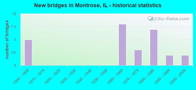
- New bridges - historical statistics
- 51900-1909
- 81960-1969
- 31970-1979
- 71980-1989
- 21990-1999
- 22000-2009


- Bridge Condition - Deck
- 15.0%Very good
- 55.0%Good
- 25.0%Satisfactory
- 5.0%Fair

- Bridge Condition - Superstructure
- 15.0%Very good
- 55.0%Good
- 20.0%Satisfactory
- 5.0%Fair
- 5.0%Serious

- Bridge Condition - Substructure
- 30.0%Very good
- 30.0%Good
- 30.0%Satisfactory
- 5.0%Fair
- 5.0%Poor

- Bridge Condition - Channel
- 31.6%Very good
- 26.3%Good
- 36.8%Satisfactory
- 5.3%Fair

- Bridge Condition - Culverts
- 33.3%Good
- 66.7%Fair
Find on map >> Show street view
Structure Number: 180035, Location: 1.4MI NE EFF CO LINE (Lat: 39.183781, Lng: -88.345156), Route carried "on" structure: County highway , Year Built: 1968, Status: Open, Structure Length: 7.05m (23.13ft), Average Daily Traffic: 100 (year 2021), Truck Traffic: 11%, Average Future Daily Traffic: 183 (year 2032), Design Load: HS 15, Features Intersected: I-70, Facility Carried by Structure: TR 68
Minimum Vertical Clearance: 30+ m (98+ ft), Kilometerpoint: 1.014, Lanes on structure: 2, Lanes under structure: 4, Owner: State Highway Agency, Approaching Roadway Width: 4.9m (16.1ft), Skew: 1 degrees, Material/Design: Steel continuous, Design/Construction: Stringer/Multi-beam, Number Of Spans In Main Unit: 4, Length of Maximum Span: 21.8m (71.5ft), Curb-To-Curb Width: 8.1m (26.6ft), Out-to-Out Width: 9.1m (29.9ft)
Condition: Deck: Satisfactory, Superstructure: Good, Substructure: Good, Operating Rating: 54.1 metric tons, Method Used To Determine Operating Rating: Load Factor (LF) rating reported by rating factor (RF) method using MS18 loading, Inventory Rating: 32.4 metric tons, Method Used To Determine Inventory Rating: Load Factor (LF) rating reported by rating factor (RF) method using MS18 loading, Structural Evaluation: Better than present minimum criteria, Deck Geometry: Equal to present minimum criteria, Underclear: Meets minimum limits, Approach Roadway Alignment: Better than present minimum criteria, Designated Inspection Frequency: Every 24 months, Inspection Date: January 2021, Deck Structure Type: Concrete Cast-file-Place
Find on map >> Show street view
Structure Number: 180057, Location: .5 MI N EFFHAM LINE (Lat: 39.179878, Lng: -88.377583), Route carried "on" structure: Other road , Year Built: 1981, Status: Open, Structure Length: 3.32m (10.89ft), Average Daily Traffic: 2,650 (year 2021), Truck Traffic: 21%, Average Future Daily Traffic: 1,991 (year 2032), Design Load: HS 25 or greater, Features Intersected: SPRING POINT CREEK, Facility Carried by Structure: FAP 828
Minimum Vertical Clearance: 30+ m (98+ ft), Kilometerpoint: 20.181, Lanes on structure: 2, Base Highway Network: Yes, Owner: State Highway Agency, Approaching Roadway Width: 7.6m (24.9ft), Material/Design: Concrete continuous, Design/Construction: Slab, Number Of Spans In Main Unit: 3, Length of Maximum Span: 11.3m (37.1ft), Curb-To-Curb Width: 10.4m (34.1ft), Out-to-Out Width: 11.0m (36.1ft)
Condition: Deck: Good, Superstructure: Good, Substructure: Good, Channel: Satisfactory, Operating Rating: 52.8 metric tons, Method Used To Determine Operating Rating: Load Factor (LF) rating reported by rating factor (RF) method using MS18 loading, Inventory Rating: 31.4 metric tons, Method Used To Determine Inventory Rating: Load Factor (LF) rating reported by rating factor (RF) method using MS18 loading, Structural Evaluation: Better than present minimum criteria, Deck Geometry: Somewhat better than minimum adequacy, Waterway Adequacy: Better than present minimum criteria, Approach Roadway Alignment: Equal to present desirable criteria, Length Of Structure Improvement: 3.32m (10.89ft), Designated Inspection Frequency: Every 12 months, Inspection Date: September 2021, Bridge Improvement Cost: $471,000, Roadway Improvement Cost: $78,000, Total Project Cost: $549,000, Deck Structure Type: Concrete Cast-file-Place, Wearing Surface/Protective System: Deck Protection: Epoxy Coated Reinforcing
Find on map >> Show street view
Structure Number: 183128, Location: 2.0 MI SW ROSYLN (Lat: 39.222031, Lng: -88.411911), Route carried "on" structure: County highway , Year Built: 1979, Status: Open, Structure Length: 1.40m (4.59ft), Average Daily Traffic: 100 (year 2021), Truck Traffic: 7%, Average Future Daily Traffic: 52 (year 2032), Design Load: HS 20, Features Intersected: SPRING POINT CREEK, Facility Carried by Structure: TR 181
Minimum Vertical Clearance: 30+ m (98+ ft), Kilometerpoint: 0.676, Lanes on structure: 2, Owner: Town or Township Highway Agency, Approaching Roadway Width: 4.9m (16.1ft), Skew: 3 degrees, Material/Design: Prestressed concrete, Design/Construction: Box Beam or Girders - Multiple, Number Of Spans In Main Unit: 1, Length of Maximum Span: 13.4m (44.0ft), Curb-To-Curb Width: 8.2m (26.9ft), Out-to-Out Width: 8.3m (27.2ft)
Condition: Deck: Good, Superstructure: Good, Substructure: Satisfactory, Channel: Good, Operating Rating: 44.4 metric tons, Method Used To Determine Operating Rating: Assigned rating based on Load Factor Design (LFD) reported by rating factor (RF) using MS18 loading, Inventory Rating: 32.4 metric tons, Method Used To Determine Inventory Rating: Assigned rating based on Load Factor Design (LFD) reported by rating factor (RF) using MS18 loading, Structural Evaluation: Equal to present minimum criteria, Deck Geometry: Equal to present minimum criteria, Waterway Adequacy: Equal to present minimum criteria, Approach Roadway Alignment: Equal to present desirable criteria, Designated Inspection Frequency: Every 24 months, Inspection Date: March 2021, Deck Structure Type: Concrete Precast Panels, Wearing Surface/Protective System: Wearing Surface: Gravel
Find on map >> Show street view
Structure Number: 183136, Location: 4.5 MI W JEWETT (Lat: 39.208647, Lng: -88.335911), Route carried "on" structure: County highway , Year Built: 1979, Status: Open, Structure Length: 1.95m (6.40ft), Average Daily Traffic: 100 (year 2021), Truck Traffic: 7%, Average Future Daily Traffic: 79 (year 2032), Design Load: HS 20, Features Intersected: SPRING POINT CREEK, Facility Carried by Structure: TR 82
Minimum Vertical Clearance: 30+ m (98+ ft), Kilometerpoint: 2.301, Lanes on structure: 2, Owner: Town or Township Highway Agency, Approaching Roadway Width: 5.2m (17.1ft), Skew: 4 degrees, Material/Design: Prestressed concrete, Design/Construction: Box Beam or Girders - Multiple, Number Of Spans In Main Unit: 1, Length of Maximum Span: 18.9m (62.0ft), Curb-To-Curb Width: 8.2m (26.9ft), Out-to-Out Width: 8.3m (27.2ft)
Condition: Deck: Good, Superstructure: Good, Substructure: Good, Channel: Good, Operating Rating: 44.4 metric tons, Method Used To Determine Operating Rating: Assigned rating based on Load Factor Design (LFD) reported by rating factor (RF) using MS18 loading, Inventory Rating: 32.4 metric tons, Method Used To Determine Inventory Rating: Assigned rating based on Load Factor Design (LFD) reported by rating factor (RF) using MS18 loading, Structural Evaluation: Better than present minimum criteria, Deck Geometry: Equal to present minimum criteria, Waterway Adequacy: Equal to present minimum criteria, Approach Roadway Alignment: Somewhat better than minimum adequacy, Designated Inspection Frequency: Every 48 months, Inspection Date: March 2019, Deck Structure Type: Concrete Precast Panels, Wearing Surface/Protective System: Wearing Surface: Gravel
Find on map >> Show street view
Structure Number: 183149, Location: 2.8 MI NW MONTROSE (Lat: 39.193017, Lng: -88.404942), Route carried "on" structure: County highway , Year Built: 1983, Status: Open, Structure Length: 1.37m (4.49ft), Average Daily Traffic: 150 (year 2021), Truck Traffic: 3%, Average Future Daily Traffic: 131 (year 2032), Design Load: HS 20, Features Intersected: SPRING POINT CREEK, Facility Carried by Structure: TR 203
Minimum Vertical Clearance: 30+ m (98+ ft), Kilometerpoint: 5.697, Lanes on structure: 2, Owner: Town or Township Highway Agency, Approaching Roadway Width: 5.2m (17.1ft), Material/Design: Prestressed concrete, Design/Construction: Box Beam or Girders - Multiple, Number Of Spans In Main Unit: 1, Length of Maximum Span: 13.4m (44.0ft), Curb-To-Curb Width: 8.2m (26.9ft), Out-to-Out Width: 8.2m (26.9ft)
Condition: Deck: Good, Superstructure: Good, Substructure: Satisfactory, Channel: Satisfactory, Operating Rating: 44.4 metric tons, Method Used To Determine Operating Rating: Assigned rating based on Load Factor Design (LFD) reported by rating factor (RF) using MS18 loading, Inventory Rating: 32.4 metric tons, Method Used To Determine Inventory Rating: Assigned rating based on Load Factor Design (LFD) reported by rating factor (RF) using MS18 loading, Structural Evaluation: Equal to present minimum criteria, Deck Geometry: Somewhat better than minimum adequacy, Waterway Adequacy: Equal to present minimum criteria, Approach Roadway Alignment: Equal to present desirable criteria, Designated Inspection Frequency: Every 24 months, Inspection Date: March 2021, Deck Structure Type: Concrete Precast Panels, Wearing Surface/Protective System: Wearing Surface: Gravel
Find on map >> Show street view
Structure Number: 183159, Location: 3.1 MI W OF WOODBURY (Lat: 39.192964, Lng: -88.361578), Route carried "on" structure: County highway , Year Built: 1987, Status: Open, Structure Length: 1.16m (3.81ft), Average Daily Traffic: 75 (year 2021), Truck Traffic: 5%, Average Future Daily Traffic: 79 (year 2032), Design Load: HS 20, Features Intersected: SPRING POINT CREEK, Facility Carried by Structure: TR 205
Minimum Vertical Clearance: 30+ m (98+ ft), Kilometerpoint: 1.400, Lanes on structure: 2, Owner: Town or Township Highway Agency, Approaching Roadway Width: 7.3m (24.0ft), Skew: 1 degrees, Material/Design: Concrete, Design/Construction: Channel Beam, Number Of Spans In Main Unit: 1, Length of Maximum Span: 10.4m (34.1ft), Curb-To-Curb Width: 8.0m (26.2ft), Out-to-Out Width: 8.0m (26.2ft)
Condition: Deck: Good, Superstructure: Good, Substructure: Very good, Channel: Very good, Operating Rating: 44.4 metric tons, Method Used To Determine Operating Rating: Assigned rating based on Load Factor Design (LFD) reported by rating factor (RF) using MS18 loading, Inventory Rating: 32.4 metric tons, Method Used To Determine Inventory Rating: Assigned rating based on Load Factor Design (LFD) reported by rating factor (RF) using MS18 loading, Structural Evaluation: Better than present minimum criteria, Deck Geometry: Equal to present minimum criteria, Waterway Adequacy: Equal to present minimum criteria, Approach Roadway Alignment: Equal to present minimum criteria, Designated Inspection Frequency: Every 48 months, Inspection Date: March 2021, Deck Structure Type: Concrete Precast Panels, Wearing Surface/Protective System: Wearing Surface: Gravel
Find on map >> Show street view
Structure Number: 183187, Location: 3.5 MI NE MONTROSE (Lat: 39.202142, Lng: -88.347569), Route carried "on" structure: County highway , Year Built: 2001, Status: Open, Structure Length: 4.68m (15.35ft), Average Daily Traffic: 75 (year 2021), Truck Traffic: 5%, Average Future Daily Traffic: 52 (year 2032), Design Load: HS 20, Features Intersected: SPRING POINT CREEK, Facility Carried by Structure: TR 66
Minimum Vertical Clearance: 30+ m (98+ ft), Kilometerpoint: 3.186, Lanes on structure: 2, Owner: Town or Township Highway Agency, Approaching Roadway Width: 4.9m (16.1ft), Skew: 3 degrees, Material/Design: Prestressed concrete, Design/Construction: Box Beam or Girders - Multiple, Number Of Spans In Main Unit: 3, Length of Maximum Span: 15.2m (49.9ft), Curb-To-Curb Width: 8.5m (27.9ft), Out-to-Out Width: 8.5m (27.9ft)
Condition: Deck: Good, Superstructure: Good, Substructure: Good, Channel: Very good, Operating Rating: 44.1 metric tons, Method Used To Determine Operating Rating: Assigned rating based on Load Factor Design (LFD) reported by rating factor (RF) using MS18 loading, Inventory Rating: 32.4 metric tons, Method Used To Determine Inventory Rating: Assigned rating based on Load Factor Design (LFD) reported by rating factor (RF) using MS18 loading, Structural Evaluation: Better than present minimum criteria, Deck Geometry: Better than present minimum criteria, Waterway Adequacy: Equal to present desirable criteria, Approach Roadway Alignment: Equal to present desirable criteria, Designated Inspection Frequency: Every 48 months, Inspection Date: March 2021, Deck Structure Type: Concrete Precast Panels, Wearing Surface/Protective System: Wearing Surface: Gravel
Find on map >> Show street view
Structure Number: 183188, Location: T9N R7E Sec 22 (Lat: 39.214753, Lng: -88.414308), Route carried "on" structure: County highway , Year Built: 2002, Status: Open, Structure Length: 1.52m (4.99ft), Average Daily Traffic: 20 (year 2021), Truck Traffic: 5%, Average Future Daily Traffic: 75 (year 2038), Design Load: HS 20, Features Intersected: Spring Point Creek, Facility Carried by Structure: TR 189
Minimum Vertical Clearance: 30+ m (98+ ft), Kilometerpoint: 4.876, Lanes on structure: 2, Owner: Town or Township Highway Agency, Approaching Roadway Width: 4.9m (16.1ft), Material/Design: Prestressed concrete, Design/Construction: Box Beam or Girders - Multiple, Number Of Spans In Main Unit: 1, Length of Maximum Span: 14.6m (47.9ft), Curb-To-Curb Width: 8.2m (26.9ft), Out-to-Out Width: 8.3m (27.2ft)
Condition: Deck: Good, Superstructure: Good, Substructure: Very good, Channel: Very good, Operating Rating: 70.6 metric tons, Method Used To Determine Operating Rating: Load Factor (LF) rating reported by rating factor (RF) method using MS18 loading, Inventory Rating: 42.1 metric tons, Method Used To Determine Inventory Rating: Load Factor (LF) rating reported by rating factor (RF) method using MS18 loading, Structural Evaluation: Better than present minimum criteria, Deck Geometry: Equal to present minimum criteria, Waterway Adequacy: Equal to present desirable criteria, Approach Roadway Alignment: Equal to present desirable criteria, Designated Inspection Frequency: Every 48 months, Inspection Date: Febuary 2022, Deck Structure Type: Concrete Precast Panels, Wearing Surface/Protective System: Wearing Surface: Gravel
Find on map >> Show street view
Structure Number: 250016, Location: MONTROSE INT (Lat: 39.168950, Lng: -88.379239), Route carried "on" structure: Interstate 70, Year Built: 1960, Status: Open, Structure Length: 3.69m (12.11ft), Average Daily Traffic: 13,000 (year 2021), Truck Traffic: 58%, Average Future Daily Traffic: 10,067 (year 2032), Design Load: HS 20+Mod, Features Intersected: FAP-828
Minimum Vertical Clearance: 30+ m (98+ ft), Kilometerpoint: 176.267, Lanes on structure: 2, Lanes under structure: 2, Base Highway Network: Yes, Owner: State Highway Agency, Approaching Roadway Width: 11.6m (38.1ft), Skew: 1 degrees, Material/Design: Steel continuous, Design/Construction: Stringer/Multi-beam, Number Of Spans In Main Unit: 3, Length of Maximum Span: 12.8m (42.0ft), Curb-To-Curb Width: 12.3m (40.4ft), Out-to-Out Width: 13.2m (43.3ft)
Condition: Deck: Satisfactory, Superstructure: Satisfactory, Substructure: Satisfactory, Operating Rating: 65.4 metric tons, Method Used To Determine Operating Rating: Load Factor (LF) rating reported by rating factor (RF) method using MS18 loading, Inventory Rating: 35.3 metric tons, Method Used To Determine Inventory Rating: Load Factor (LF) rating reported by rating factor (RF) method using MS18 loading, Structural Evaluation: Equal to present minimum criteria, Deck Geometry: Better than present minimum criteria, Underclear: Equal to present minimum criteria, Approach Roadway Alignment: Equal to present desirable criteria, Designated Inspection Frequency: Every 24 months, Inspection Date: June 2020, Deck Structure Type: Concrete Cast-file-Place, Wearing Surface/Protective System: Wearing Surface: Other
Find on map >> Show street view
Structure Number: 250017, Location: MONTROSE INT (Lat: 39.168983, Lng: -88.379017), Route carried "on" structure: Interstate 70, Year Built: 1960, Status: Open, Structure Length: 3.69m (12.11ft), Average Daily Traffic: 13,000 (year 2021), Truck Traffic: 58%, Average Future Daily Traffic: 10,067 (year 2032), Design Load: HS 20+Mod, Features Intersected: FAP-828
Minimum Vertical Clearance: 30+ m (98+ ft), Kilometerpoint: 176.283, Lanes on structure: 2, Lanes under structure: 2, Base Highway Network: Yes, Owner: State Highway Agency, Approaching Roadway Width: 11.6m (38.1ft), Skew: 1 degrees, Material/Design: Steel continuous, Design/Construction: Stringer/Multi-beam, Number Of Spans In Main Unit: 3, Length of Maximum Span: 12.8m (42.0ft), Curb-To-Curb Width: 12.3m (40.4ft), Out-to-Out Width: 13.2m (43.3ft)
Condition: Deck: Satisfactory, Superstructure: Satisfactory, Substructure: Satisfactory, Operating Rating: 65.4 metric tons, Method Used To Determine Operating Rating: Load Factor (LF) rating reported by rating factor (RF) method using MS18 loading, Inventory Rating: 35.3 metric tons, Method Used To Determine Inventory Rating: Load Factor (LF) rating reported by rating factor (RF) method using MS18 loading, Structural Evaluation: Equal to present minimum criteria, Deck Geometry: Better than present minimum criteria, Underclear: Equal to present minimum criteria, Approach Roadway Alignment: Equal to present desirable criteria, Designated Inspection Frequency: Every 24 months, Inspection Date: June 2020, Deck Structure Type: Concrete Cast-file-Place, Wearing Surface/Protective System: Wearing Surface: Other
Find on map >> Show street view
Structure Number: 250052, Location: 6.5 MI E US-45 INT (Lat: 39.163425, Lng: -88.416544), Route carried "on" structure: County highway , Year Built: 1960, Status: Open, Structure Length: 6.83m (22.41ft), Average Daily Traffic: 275 (year 2018), Truck Traffic: 7%, Average Future Daily Traffic: 187 (year 2032), Design Load: HS 15, Features Intersected: FAI-70, Facility Carried by Structure: CH-13
Minimum Vertical Clearance: 4.90m (16.08ft), Kilometerpoint: 0.949, Lanes on structure: 2, Lanes under structure: 4, Owner: State Highway Agency, Approaching Roadway Width: 6.1m (20.0ft), Skew: 1 degrees, Material/Design: Steel continuous, Design/Construction: Stringer/Multi-beam, Number Of Spans In Main Unit: 4, Length of Maximum Span: 21.0m (68.9ft), Curb or Sidewalk Widths: Left: 0.6m (2.0ft), Right: 0.6m (2.0ft), Curb-To-Curb Width: 7.3m (24.0ft), Out-to-Out Width: 9.1m (29.9ft)
Condition: Deck: Good, Superstructure: Satisfactory, Substructure: Good, Operating Rating: 47.6 metric tons, Method Used To Determine Operating Rating: Load Factor (LF) rating reported by rating factor (RF) method using MS18 loading, Inventory Rating: 28.5 metric tons, Method Used To Determine Inventory Rating: Load Factor (LF) rating reported by rating factor (RF) method using MS18 loading, Structural Evaluation: Equal to present minimum criteria, Deck Geometry: Somewhat better than minimum adequacy, Underclear: High priority of corrective action, Approach Roadway Alignment: Equal to present desirable criteria, Designated Inspection Frequency: Every 24 months, Inspection Date: January 2021, Deck Structure Type: Concrete Cast-file-Place, Wearing Surface/Protective System: Deck Protection: Epoxy Coated Reinforcing
Find on map >> Show street view
Structure Number: 252019, Location: S EDGE MONTROSE (Lat: 39.153925, Lng: -88.379208), Route carried "on" structure: Other road , Year Built: 1909, Year Reconstructed: 1937, Status: Open, Structure Length: 0.67m (2.20ft), Average Daily Traffic: 2,900 (year 2021), Truck Traffic: 19%, Average Future Daily Traffic: 3,052 (year 2032), Features Intersected: STREAM, Facility Carried by Structure: FAP-828 (CC-MONT B
Minimum Vertical Clearance: 30+ m (98+ ft), Kilometerpoint: 1.915, Lanes on structure: 2, Base Highway Network: Yes, Owner: State Highway Agency, Approaching Roadway Width: 7.3m (24.0ft), Material/Design: Concrete, Design/Construction: Culvert, Number Of Spans In Main Unit: 2, Length of Maximum Span: 3.3m (10.8ft)
Condition: Channel: Good, Culverts: Fair, Operating Rating: 64.5 metric tons, Method Used To Determine Operating Rating: Load Factor (LF) rating reported by rating factor (RF) method using MS18 loading, Inventory Rating: 38.6 metric tons, Method Used To Determine Inventory Rating: Load Factor (LF) rating reported by rating factor (RF) method using MS18 loading, Structural Evaluation: Somewhat better than minimum adequacy, Waterway Adequacy: Better than present minimum criteria, Approach Roadway Alignment: Equal to present desirable criteria, Designated Inspection Frequency: Every 24 months, Other Special Inspection Frequency: Every 6 months, Inspection Date: September 2021, Other Special Inspection Date: December 2021
Find on map >> Show street view
Structure Number: 253045, Location: 3.5 MI NE DIETERICH (Lat: 39.115217, Lng: -88.360506), Route carried "on" structure: County highway , Year Built: 1909, Status: Closed, Structure Length: 0.79m (2.59ft), Average Daily Traffic: 25 (year 2021), Truck Traffic: 8%, Average Future Daily Traffic: 10 (year 2032), Features Intersected: DRAINAGE DITCH, Facility Carried by Structure: TR-6
Minimum Vertical Clearance: 30+ m (98+ ft), Kilometerpoint: 1.947, Lanes on structure: 2, Owner: Town or Township Highway Agency, Approaching Roadway Width: 6.1m (20.0ft), Material/Design: Steel, Design/Construction: Stringer/Multi-beam, Number Of Spans In Main Unit: 2, Length of Maximum Span: 4.0m (13.1ft), Curb-To-Curb Width: 5.8m (19.0ft), Out-to-Out Width: 5.8m (19.0ft)
Condition: Deck: Fair, Superstructure: Serious, Substructure: Poor, Channel: Fair, Operating Rating: 3.6 metric tons, Method Used To Determine Operating Rating: Load Factor (LF) rating reported by rating factor (RF) method using MS18 loading, Inventory Rating: 1.6 metric tons, Method Used To Determine Inventory Rating: Load Factor (LF) rating reported by rating factor (RF) method using MS18 loading, Deck Geometry: Meets minimum limits, Waterway Adequacy: High priority of corrective action, Approach Roadway Alignment: Equal to present minimum criteria, Bridge Posting: Required (Relationship of Operating Rating to Maximum Legal Load: > 39.9% below), Length Of Structure Improvement: 1.43m (4.69ft), Designated Inspection Frequency: Every 24 months, Inspection Date: November 2020, Bridge Improvement Cost: $52,000, Roadway Improvement Cost: $5,000, Total Project Cost: $78,000, Deck Structure Type: Concrete Cast-file-Place, Wearing Surface/Protective System: Wearing Surface: Gravel
Find on map >> Show street view
Structure Number: 253145, Location: 2 MI SW MONTROSE (Lat: 39.130661, Lng: -88.397869), Route carried "on" structure: County highway , Year Built: 1909, Status: Posted for load, Structure Length: 0.76m (2.49ft), Average Daily Traffic: 10 (year 2018), Truck Traffic: 10%, Average Future Daily Traffic: 11 (year 2032), Features Intersected: LITTLE SALT CREEK, Facility Carried by Structure: TR-316
Minimum Vertical Clearance: 30+ m (98+ ft), Kilometerpoint: 0.290, Lanes on structure: 1, Owner: Town or Township Highway Agency, Approaching Roadway Width: 6.1m (20.0ft), Material/Design: Steel, Design/Construction: Stringer/Multi-beam, Number Of Spans In Main Unit: 1, Length of Maximum Span: 7.3m (24.0ft), Curb-To-Curb Width: 4.7m (15.4ft), Out-to-Out Width: 4.9m (16.1ft)
Condition: Deck: Satisfactory, Superstructure: Fair, Substructure: Fair, Channel: Satisfactory, Operating Rating: 11.3 metric tons, Method Used To Determine Operating Rating: Load Factor (LF) rating reported by rating factor (RF) method using MS18 loading, Inventory Rating: 6.8 metric tons, Method Used To Determine Inventory Rating: Load Factor (LF) rating reported by rating factor (RF) method using MS18 loading, Structural Evaluation: High priority of replacement, Deck Geometry: Better than present minimum criteria, Waterway Adequacy: Equal to present desirable criteria, Approach Roadway Alignment: Equal to present minimum criteria, Bridge Posting: Required (Relationship of Operating Rating to Maximum Legal Load: > 39.9% below), Length Of Structure Improvement: 1.37m (4.49ft), Designated Inspection Frequency: Every 24 months, Inspection Date: January 2021, Bridge Improvement Cost: $42,000, Roadway Improvement Cost: $5,000, Total Project Cost: $64,000, Deck Structure Type: Concrete Cast-file-Place, Wearing Surface/Protective System: Wearing Surface: Gravel
Find on map >> Show street view
Structure Number: 253203, Location: 2 MI SW MONTROSE (Lat: 39.129847, Lng: -88.416606), Route carried "on" structure: County highway , Year Built: 1973, Status: Open, Structure Length: 0.82m (2.69ft), Average Daily Traffic: 250 (year 2018), Truck Traffic: 6%, Average Future Daily Traffic: 214 (year 2032), Features Intersected: LITTLE SALT CREEK, Facility Carried by Structure: CH-13
Minimum Vertical Clearance: 30+ m (98+ ft), Kilometerpoint: 4.715, Lanes on structure: 2, Owner: County Highway Agency, Approaching Roadway Width: 8.5m (27.9ft), Material/Design: Concrete, Design/Construction: Culvert, Number Of Spans In Main Unit: 2, Length of Maximum Span: 4.0m (13.1ft)
Condition: Channel: Satisfactory, Culverts: Good, Operating Rating: 40.5 metric tons, Method Used To Determine Operating Rating: Field evaluation and documented engineering judgment, Inventory Rating: 24.3 metric tons, Method Used To Determine Inventory Rating: Field evaluation and documented engineering judgment, Structural Evaluation: Equal to present minimum criteria, Waterway Adequacy: Better than present minimum criteria, Approach Roadway Alignment: Equal to present desirable criteria, Designated Inspection Frequency: Every 24 months, Inspection Date: December 2020, Wearing Surface/Protective System: Wearing Surface: Gravel
Find on map >> Show street view
Structure Number: 25321, Location: 2MI W MONTROSE (Lat: 39.150081, Lng: -88.416550), Route carried "on" structure: County highway , Year Built: 1984, Status: Open, Structure Length: 0.79m (2.59ft), Average Daily Traffic: 275 (year 2018), Truck Traffic: 7%, Average Future Daily Traffic: 187 (year 2032), Design Load: HS 20, Features Intersected: FIRST SALT CREEK, Facility Carried by Structure: CH-13 PUMPING STA
Minimum Vertical Clearance: 30+ m (98+ ft), Kilometerpoint: 2.462, Lanes on structure: 2, Owner: County Highway Agency, Approaching Roadway Width: 8.5m (27.9ft), Material/Design: Prestressed concrete, Design/Construction: Box Beam or Girders - Multiple, Number Of Spans In Main Unit: 1, Length of Maximum Span: 7.0m (23.0ft), Curb-To-Curb Width: 8.5m (27.9ft), Out-to-Out Width: 8.5m (27.9ft)
Condition: Deck: Very good, Superstructure: Very good, Substructure: Satisfactory, Channel: Satisfactory, Operating Rating: 56.1 metric tons, Method Used To Determine Operating Rating: Load Factor (LF) rating reported by rating factor (RF) method using MS18 loading, Inventory Rating: 33.4 metric tons, Method Used To Determine Inventory Rating: Load Factor (LF) rating reported by rating factor (RF) method using MS18 loading, Structural Evaluation: Equal to present minimum criteria, Deck Geometry: Equal to present minimum criteria, Waterway Adequacy: Better than present minimum criteria, Approach Roadway Alignment: Equal to present desirable criteria, Designated Inspection Frequency: Every 24 months, Inspection Date: January 2021, Deck Structure Type: Concrete Precast Panels, Wearing Surface/Protective System: Wearing Surface: Gravel
Find on map >> Show street view
Structure Number: 258604, Location: MP 22.68 (Lat: 39.149036, Lng: -88.418356), Route carried "on" structure: US 40, Year Built: 1909, Status: Open, Structure Length: 0.70m (2.30ft), Average Daily Traffic: 3,150 (year 2021), Truck Traffic: 13%, Average Future Daily Traffic: 3,213 (year 2032), Features Intersected: STREAM
Minimum Vertical Clearance: 30+ m (98+ ft), Kilometerpoint: 172.935, Lanes on structure: 2, Base Highway Network: Yes, Owner: State Highway Agency, Approaching Roadway Width: 7.3m (24.0ft), Skew: 5 degrees, Material/Design: Concrete, Design/Construction: Culvert, Number Of Spans In Main Unit: 1, Length of Maximum Span: 6.7m (22.0ft)
Condition: Channel: Satisfactory, Culverts: Fair, Operating Rating: 43.1 metric tons, Method Used To Determine Operating Rating: Field evaluation and documented engineering judgment, Inventory Rating: 25.9 metric tons, Method Used To Determine Inventory Rating: Field evaluation and documented engineering judgment, Structural Evaluation: Somewhat better than minimum adequacy, Waterway Adequacy: Equal to present desirable criteria, Approach Roadway Alignment: Equal to present desirable criteria, Designated Inspection Frequency: Every 24 months, Inspection Date: August 2021
Find on map >> Show street view
Structure Number: 403049, Location: 2 MI E EFFINGHAM CL (Lat: 39.143744, Lng: -88.317014), Route carried "on" structure: County highway , Year Built: 1909, Status: Posted for load, Structure Length: 0.85m (2.79ft), Average Daily Traffic: 50 (year 2021), Truck Traffic: 8%, Average Future Daily Traffic: 51 (year 2032), Features Intersected: ISLAND CREEK, Facility Carried by Structure: TR-44
Minimum Vertical Clearance: 30+ m (98+ ft), Kilometerpoint: 0.145, Lanes on structure: 1, Owner: Town or Township Highway Agency, Approaching Roadway Width: 4.9m (16.1ft), Material/Design: Steel, Design/Construction: Stringer/Multi-beam, Number Of Spans In Main Unit: 1, Length of Maximum Span: 8.2m (26.9ft), Curb-To-Curb Width: 6.6m (21.7ft), Out-to-Out Width: 6.6m (21.7ft)
Condition: Deck: Satisfactory, Superstructure: Satisfactory, Substructure: Satisfactory, Channel: Satisfactory, Operating Rating: 35.6 metric tons, Method Used To Determine Operating Rating: Load Factor (LF) rating reported by rating factor (RF) method using MS18 loading, Inventory Rating: 17.5 metric tons, Method Used To Determine Inventory Rating: Load Factor (LF) rating reported by rating factor (RF) method using MS18 loading, Structural Evaluation: Somewhat better than minimum adequacy, Deck Geometry: Somewhat better than minimum adequacy, Waterway Adequacy: Somewhat better than minimum adequacy, Approach Roadway Alignment: Meets minimum limits, Bridge Posting: Required (Relationship of Operating Rating to Maximum Legal Load: > 39.9% below), Length Of Structure Improvement: 1.46m (4.79ft), Designated Inspection Frequency: Every 24 months, Inspection Date: December 2021, Bridge Improvement Cost: $64,000, Roadway Improvement Cost: $6,000, Total Project Cost: $96,000, Deck Structure Type: Concrete Cast-file-Place, Wearing Surface/Protective System: Wearing Surface: Bituminous
Find on map >> Show street view
Structure Number: 403164, Location: 8.5 MI N WHEELER (Lat: 39.167094, Lng: -88.320986), Route carried "on" structure: County highway , Year Built: 1980, Status: Open, Structure Length: 1.74m (5.71ft), Average Daily Traffic: 300 (year 2021), Truck Traffic: 13%, Average Future Daily Traffic: 255 (year 2032), Design Load: HS 20, Features Intersected: WEBSTER BRANCH, Facility Carried by Structure: TR-11
Minimum Vertical Clearance: 30+ m (98+ ft), Kilometerpoint: 3.573, Lanes on structure: 2, Owner: Town or Township Highway Agency, Approaching Roadway Width: 7.9m (25.9ft), Skew: 3 degrees, Material/Design: Prestressed concrete, Design/Construction: Box Beam or Girders - Multiple, Number Of Spans In Main Unit: 1, Length of Maximum Span: 16.2m (53.1ft), Curb-To-Curb Width: 8.3m (27.2ft), Out-to-Out Width: 8.3m (27.2ft)
Condition: Deck: Good, Superstructure: Good, Substructure: Very good, Channel: Good, Operating Rating: 44.4 metric tons, Method Used To Determine Operating Rating: Assigned rating based on Load Factor Design (LFD) reported by rating factor (RF) using MS18 loading, Inventory Rating: 32.4 metric tons, Method Used To Determine Inventory Rating: Assigned rating based on Load Factor Design (LFD) reported by rating factor (RF) using MS18 loading, Structural Evaluation: Better than present minimum criteria, Deck Geometry: Somewhat better than minimum adequacy, Waterway Adequacy: Equal to present desirable criteria, Approach Roadway Alignment: Better than present minimum criteria, Designated Inspection Frequency: Every 48 months, Inspection Date: January 2022, Deck Structure Type: Concrete Precast Panels
Find on map >> Show street view
Structure Number: 403178, Location: 1.5MI N ISLAND GROVE (Lat: 39.126636, Lng: -88.335431), Route carried "on" structure: County highway , Year Built: 1982, Status: Open, Structure Length: 2.13m (6.99ft), Average Daily Traffic: 100 (year 2021), Truck Traffic: 6%, Average Future Daily Traffic: 128 (year 2032), Design Load: HS 20, Features Intersected: ISLAND CREEK, Facility Carried by Structure: TR-32
Minimum Vertical Clearance: 30+ m (98+ ft), Kilometerpoint: 4.587, Lanes on structure: 2, Owner: Town or Township Highway Agency, Approaching Roadway Width: 7.3m (24.0ft), Material/Design: Prestressed concrete, Design/Construction: Box Beam or Girders - Multiple, Number Of Spans In Main Unit: 1, Length of Maximum Span: 20.7m (67.9ft), Curb-To-Curb Width: 8.3m (27.2ft), Out-to-Out Width: 8.3m (27.2ft)
Condition: Deck: Good, Superstructure: Good, Substructure: Very good, Channel: Very good, Operating Rating: 44.4 metric tons, Method Used To Determine Operating Rating: Assigned rating based on Load Factor Design (LFD) reported by rating factor (RF) using MS18 loading, Inventory Rating: 32.4 metric tons, Method Used To Determine Inventory Rating: Assigned rating based on Load Factor Design (LFD) reported by rating factor (RF) using MS18 loading, Structural Evaluation: Better than present minimum criteria, Deck Geometry: Equal to present minimum criteria, Waterway Adequacy: Equal to present desirable criteria, Approach Roadway Alignment: Better than present minimum criteria, Designated Inspection Frequency: Every 48 months, Inspection Date: January 2022, Deck Structure Type: Concrete Precast Panels
Find on map >> Show street view
Structure Number: 403199, Location: 3 MI NE ISLAND GROVE (Lat: 39.144958, Lng: -88.315719), Route carried "on" structure: County highway , Year Built: 1989, Status: Open, Structure Length: 1.04m (3.41ft), Average Daily Traffic: 100 (year 2021), Truck Traffic: 4%, Average Future Daily Traffic: 153 (year 2032), Design Load: HS 20, Features Intersected: ISLAND CREEK, Facility Carried by Structure: TR-39
Minimum Vertical Clearance: 30+ m (98+ ft), Kilometerpoint: 3.862, Lanes on structure: 2, Owner: Town or Township Highway Agency, Approaching Roadway Width: 7.3m (24.0ft), Material/Design: Prestressed concrete, Design/Construction: Box Beam or Girders - Multiple, Number Of Spans In Main Unit: 1, Length of Maximum Span: 10.1m (33.1ft), Curb-To-Curb Width: 8.3m (27.2ft), Out-to-Out Width: 8.3m (27.2ft)
Condition: Deck: Good, Superstructure: Good, Substructure: Good, Channel: Good, Operating Rating: 44.4 metric tons, Method Used To Determine Operating Rating: Assigned rating based on Load Factor Design (LFD) reported by rating factor (RF) using MS18 loading, Inventory Rating: 32.4 metric tons, Method Used To Determine Inventory Rating: Assigned rating based on Load Factor Design (LFD) reported by rating factor (RF) using MS18 loading, Structural Evaluation: Better than present minimum criteria, Deck Geometry: Equal to present minimum criteria, Waterway Adequacy: Equal to present desirable criteria, Approach Roadway Alignment: Equal to present desirable criteria, Designated Inspection Frequency: Every 48 months, Inspection Date: Febuary 2021, Deck Structure Type: Concrete Precast Panels, Wearing Surface/Protective System: Wearing Surface: Bituminous
Find on map >> Show street view
Structure Number: 403217, Location: 2.5 MI N ISLAND GROV (Lat: 39.131458, Lng: -88.331225), Route carried "on" structure: County highway , Year Built: 1993, Status: Open, Structure Length: 1.88m (6.17ft), Average Daily Traffic: 300 (year 2021), Truck Traffic: 5%, Average Future Daily Traffic: 459 (year 2032), Design Load: HS 20, Features Intersected: ISLAND CREEK, Facility Carried by Structure: CH-6
Minimum Vertical Clearance: 30+ m (98+ ft), Kilometerpoint: 2.591, Lanes on structure: 2, Owner: County Highway Agency, Approaching Roadway Width: 6.1m (20.0ft), Skew: 2 degrees, Material/Design: Prestressed concrete, Design/Construction: Box Beam or Girders - Multiple, Number Of Spans In Main Unit: 1, Length of Maximum Span: 17.9m (58.7ft), Curb-To-Curb Width: 8.5m (27.9ft), Out-to-Out Width: 8.5m (27.9ft)
Condition: Deck: Very good, Superstructure: Very good, Substructure: Very good, Channel: Very good, Operating Rating: 44.1 metric tons, Method Used To Determine Operating Rating: Assigned rating based on Load Factor Design (LFD) reported by rating factor (RF) using MS18 loading, Inventory Rating: 32.4 metric tons, Method Used To Determine Inventory Rating: Assigned rating based on Load Factor Design (LFD) reported by rating factor (RF) using MS18 loading, Structural Evaluation: Equal to present desirable criteria, Deck Geometry: Equal to present minimum criteria, Waterway Adequacy: Equal to present desirable criteria, Approach Roadway Alignment: Equal to present desirable criteria, Designated Inspection Frequency: Every 48 months, Inspection Date: March 2019, Deck Structure Type: Concrete Precast Panels
Find on map >> Show street view
Structure Number: 403227, Location: 1.5 MI NW IS GROVE (Lat: 39.118386, Lng: -88.354850), Route carried "on" structure: County highway , Year Built: 1998, Status: Open, Structure Length: 2.33m (7.64ft), Average Daily Traffic: 100 (year 2021), Truck Traffic: 8%, Average Future Daily Traffic: 128 (year 2032), Design Load: HS 20, Features Intersected: ISLAND CREEK, Facility Carried by Structure: TR 75
Minimum Vertical Clearance: 30+ m (98+ ft), Kilometerpoint: 0.499, Lanes on structure: 2, Owner: Town or Township Highway Agency, Approaching Roadway Width: 7.3m (24.0ft), Skew: 3 degrees, Material/Design: Prestressed concrete, Design/Construction: Box Beam or Girders - Multiple, Number Of Spans In Main Unit: 3, Length of Maximum Span: 7.6m (24.9ft), Curb-To-Curb Width: 7.3m (24.0ft), Out-to-Out Width: 7.3m (24.0ft)
Condition: Deck: Very good, Superstructure: Very good, Substructure: Very good, Channel: Very good, Operating Rating: 44.1 metric tons, Method Used To Determine Operating Rating: Assigned rating based on Load Factor Design (LFD) reported by rating factor (RF) using MS18 loading, Inventory Rating: 32.4 metric tons, Method Used To Determine Inventory Rating: Assigned rating based on Load Factor Design (LFD) reported by rating factor (RF) using MS18 loading, Structural Evaluation: Equal to present desirable criteria, Deck Geometry: Equal to present minimum criteria, Waterway Adequacy: Equal to present desirable criteria, Approach Roadway Alignment: Equal to present minimum criteria, Designated Inspection Frequency: Every 48 months, Inspection Date: Febuary 2021, Deck Structure Type: Concrete Precast Panels, Wearing Surface/Protective System: Deck Protection: Epoxy Coated Reinforcing
Find on map >> Show street view
Structure Number: 180035, Location: 1.4MI NE EFF CO LINE (Lat: 39.183661, Lng: -88.345092), Route carried "under" structure: Interstate 70, Year Built: 1968, Structure Length: 0. m, Average Daily Traffic: 26,000 (year 2021), Truck Traffic: 58%, Features Intersected: I-70, Facility Carried by Structure: TR 68
Minimum Vertical Clearance: 5.11m (16.77ft), Kilometerpoint: 179.743, Lanes on structure: 2, Lanes under structure: 4, Material/Design: Steel continuous, Design/Construction: Stringer/Multi-beam, Length of Maximum Span: 21.8m (71.5ft)
Find on map >> Show street view
Structure Number: 250016, Location: MONTROSE INT (Lat: 39.168778, Lng: -88.379239), Route carried "under" structure: Other road , Year Built: 1960, Structure Length: 0. m, Average Daily Traffic: 3,400 (year 2018), Truck Traffic: 17%, Features Intersected: FAP-828, Facility Carried by Structure: FAI-70 EB
Minimum Vertical Clearance: 4.50m (14.76ft), Kilometerpoint: 0.241, Lanes on structure: 2, Lanes under structure: 2, Material/Design: Steel continuous, Design/Construction: Stringer/Multi-beam, Length of Maximum Span: 12.8m (42.0ft)
Find on map >> Show street view
Structure Number: 250017, Location: MONTROSE INT (Lat: 39.168950, Lng: -88.379239), Route carried "under" structure: Other road , Year Built: 1960, Structure Length: 0. m, Average Daily Traffic: 3,400 (year 2018), Truck Traffic: 17%, Features Intersected: FAP-828, Facility Carried by Structure: FAI-70 WB
Minimum Vertical Clearance: 4.52m (14.83ft), Kilometerpoint: 0.209, Lanes on structure: 2, Lanes under structure: 2, Material/Design: Steel continuous, Design/Construction: Stringer/Multi-beam, Length of Maximum Span: 12.8m (42.0ft)
Find on map >> Show street view
Structure Number: 250052, Location: 6.5 MI E US-45 INT (Lat: 39.163289, Lng: -88.416539), Route carried "under" structure: Interstate 70, Year Built: 1960, Structure Length: 0. m, Average Daily Traffic: 25,800 (year 2021), Truck Traffic: 58%, Features Intersected: FAI-70, Facility Carried by Structure: CH-13
Minimum Vertical Clearance: 4.90m (16.08ft), Kilometerpoint: 173.000, Lanes on structure: 2, Lanes under structure: 4, Material/Design: Steel continuous, Design/Construction: Stringer/Multi-beam, Length of Maximum Span: 21.0m (68.9ft)