Bridge Statistics for Mount Pulaski, Illinois (IL)
Condition, Traffic, Stress, Structural Evaluation, Project Costs
- National Bridge Inventory (NBI) Statistics
- 20Number of bridges
- 154ft / 46.7mTotal length
- $86,000Total costs
- 24,065Total average daily traffic
- 4,021Total average daily truck traffic
- National Bridge Inventory (NBI) Registered Bridges for Mount Pulaski
- No street view available for this location
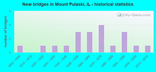
- New bridges - historical statistics
- 11900-1909
- 11920-1929
- 11930-1939
- 11940-1949
- 31950-1959
- 31960-1969
- 41970-1979
- 11980-1989
- 31990-1999
- 12000-2009
- 12010-2019


- Bridge Condition - Deck
- 37.5%Good
- 37.5%Satisfactory
- 12.5%Fair
- 12.5%Serious

- Bridge Condition - Superstructure
- 25.0%Good
- 50.0%Satisfactory
- 12.5%Fair
- 12.5%Serious

- Bridge Condition - Substructure
- 12.5%Very good
- 50.0%Satisfactory
- 12.5%Fair
- 25.0%Poor

- Bridge Condition - Channel
- 25.0%Very good
- 43.8%Good
- 12.5%Satisfactory
- 18.8%Fair

- Bridge Condition - Culverts
- 33.3%Very good
- 33.3%Good
- 22.2%Satisfactory
- 11.1%Fair
Find on map >> Show street view
Structure Number: 540021, Location: 3.9M N IL54-MT PUL.* (Lat: 40.054378, Lng: -89.282033), Route carried "on" structure: State highway 121, Year Built: 1928, Year Reconstructed: 1990, Status: Open, Structure Length: 17.47m (57.32ft), Average Daily Traffic: 3,550 (year 2021), Truck Traffic: 15%, Average Future Daily Traffic: 3,865 (year 2032), Design Load: HS 20, Features Intersected: SALT CREEK
Minimum Vertical Clearance: 30+ m (98+ ft), Kilometerpoint: 157.679, Lanes on structure: 2, Base Highway Network: Yes, Owner: State Highway Agency, Approaching Roadway Width: 9.8m (32.2ft), Material/Design: Steel continuous, Design/Construction: Stringer/Multi-beam, Number Of Spans In Main Unit: 3, Number Of Approach Spans: 7, Length of Maximum Span: 21.0m (68.9ft), Curb-To-Curb Width: 9.8m (32.2ft), Out-to-Out Width: 10.7m (35.1ft)
Condition: Deck: Good, Superstructure: Satisfactory, Substructure: Satisfactory, Channel: Very good, Operating Rating: 54.8 metric tons, Method Used To Determine Operating Rating: Load Factor (LF) rating reported by rating factor (RF) method using MS18 loading, Inventory Rating: 32.7 metric tons, Method Used To Determine Inventory Rating: Load Factor (LF) rating reported by rating factor (RF) method using MS18 loading, Structural Evaluation: Equal to present minimum criteria, Deck Geometry: Meets minimum limits, Waterway Adequacy: Superior to present desirable criteria, Approach Roadway Alignment: Equal to present desirable criteria, Designated Inspection Frequency: Every 24 months, Underwater Inspection Frequency: Every 24 months, Inspection Date: July 2021, Underwater Inspection Date: July 2021, Deck Structure Type: Concrete Cast-file-Place, Wearing Surface/Protective System: Wearing Surface: Other, Deck Protection: Epoxy Coated Reinforcing
Find on map >> Show street view
Structure Number: 54003, Location: SE EDGE MT. PULASKI (Lat: 40.000953, Lng: -89.272389), Route carried "on" structure: State highway 54, Year Built: 1971, Status: Open, Structure Length: 9.20m (30.18ft), Average Daily Traffic: 1,200 (year 2021), Truck Traffic: 14%, Average Future Daily Traffic: 1,255 (year 2032), Design Load: HS 20, Features Intersected: IL 121 & IC RR
Minimum Vertical Clearance: 30+ m (98+ ft), Kilometerpoint: 34.680, Lanes on structure: 2, Lanes under structure: 2, Base Highway Network: Yes, Owner: State Highway Agency, Approaching Roadway Width: 12.8m (42.0ft), Material/Design: Steel continuous, Design/Construction: Box Beam or Girders - Single/Spread, Number Of Spans In Main Unit: 4, Length of Maximum Span: 27.4m (89.9ft), Curb-To-Curb Width: 13.1m (43.0ft), Out-to-Out Width: 14.1m (46.3ft)
Condition: Deck: Fair, Superstructure: Fair, Substructure: Satisfactory, Operating Rating: 97.2 metric tons, Method Used To Determine Operating Rating: Load Factor (LF) rating reported by rating factor (RF) method using MS18 loading, Inventory Rating: 73.9 metric tons, Method Used To Determine Inventory Rating: Load Factor (LF) rating reported by rating factor (RF) method using MS18 loading, Structural Evaluation: Somewhat better than minimum adequacy, Deck Geometry: Better than present minimum criteria, Underclear: Superior to present desirable criteria, Approach Roadway Alignment: Equal to present desirable criteria, Designated Inspection Frequency: Every 24 months, Inspection Date: August 2021, Deck Structure Type: Concrete Cast-file-Place, Wearing Surface/Protective System: Wearing Surface: Bituminous, Membrane: Built-up
Find on map >> Show street view
Structure Number: 54203, Location: 2.7MI N MT PULASKI (Lat: 40.056672, Lng: -89.282031), Route carried "on" structure: State highway 121, Year Built: 1991, Status: Open, Structure Length: 1.68m (5.51ft), Average Daily Traffic: 3,550 (year 2021), Truck Traffic: 15%, Average Future Daily Traffic: 3,865 (year 2032), Design Load: HS 20, Features Intersected: FORK SALT CREEK
Minimum Vertical Clearance: 30+ m (98+ ft), Kilometerpoint: 157.937, Lanes on structure: 2, Base Highway Network: Yes, Owner: State Highway Agency, Approaching Roadway Width: 12.2m (40.0ft), Material/Design: Concrete, Design/Construction: Culvert, Number Of Spans In Main Unit: 5, Length of Maximum Span: 3.0m (9.8ft)
Condition: Channel: Good, Culverts: Very good, Operating Rating: 53.1 metric tons, Method Used To Determine Operating Rating: Load Factor (LF) rating reported by rating factor (RF) method using MS18 loading, Inventory Rating: 31.8 metric tons, Method Used To Determine Inventory Rating: Load Factor (LF) rating reported by rating factor (RF) method using MS18 loading, Structural Evaluation: Better than present minimum criteria, Waterway Adequacy: Superior to present desirable criteria, Approach Roadway Alignment: Equal to present desirable criteria, Designated Inspection Frequency: Every 48 months, Inspection Date: September 2018, Deck Structure Type: Concrete Cast-file-Place
Find on map >> Show street view
Structure Number: 542032, Location: 3.5 MI N MT PULASKI (Lat: 40.031322, Lng: -89.282164), Route carried "on" structure: State highway 121, Year Built: 1998, Status: Open, Structure Length: 0.67m (2.20ft), Average Daily Traffic: 3,550 (year 2021), Truck Traffic: 15%, Average Future Daily Traffic: 3,865 (year 2032), Design Load: HS 20, Features Intersected: BRANCH SALT CREEK
Minimum Vertical Clearance: 30+ m (98+ ft), Kilometerpoint: 155.120, Lanes on structure: 2, Base Highway Network: Yes, Owner: State Highway Agency, Approaching Roadway Width: 12.0m (39.4ft), Material/Design: Concrete continuous, Design/Construction: Culvert, Number Of Spans In Main Unit: 2, Length of Maximum Span: 3.0m (9.8ft)
Condition: Channel: Very good, Culverts: Good, Operating Rating: 55.1 metric tons, Method Used To Determine Operating Rating: Load Factor (LF) rating reported by rating factor (RF) method using MS18 loading, Inventory Rating: 33.0 metric tons, Method Used To Determine Inventory Rating: Load Factor (LF) rating reported by rating factor (RF) method using MS18 loading, Structural Evaluation: Better than present minimum criteria, Waterway Adequacy: Superior to present desirable criteria, Approach Roadway Alignment: Equal to present desirable criteria, Designated Inspection Frequency: Every 48 months, Inspection Date: December 2020
Find on map >> Show street view
Structure Number: 542033, Location: 0.8 MI N MT PULASKI (Lat: 40.068117, Lng: -89.289617), Route carried "on" structure: State highway 121, Year Built: 1998, Status: Open, Structure Length: 1.00m (3.28ft), Average Daily Traffic: 3,550 (year 2021), Truck Traffic: 15%, Average Future Daily Traffic: 3,815 (year 2032), Design Load: HS 20, Features Intersected: BRANCH SALT CREEK
Minimum Vertical Clearance: 30+ m (98+ ft), Kilometerpoint: 159.385, Lanes on structure: 2, Base Highway Network: Yes, Owner: State Highway Agency, Approaching Roadway Width: 12.0m (39.4ft), Skew: 2 degrees, Material/Design: Concrete continuous, Design/Construction: Culvert, Number Of Spans In Main Unit: 3, Length of Maximum Span: 3.1m (10.2ft)
Condition: Channel: Very good, Culverts: Very good, Operating Rating: 69.3 metric tons, Method Used To Determine Operating Rating: Load Factor (LF) rating reported by rating factor (RF) method using MS18 loading, Inventory Rating: 41.8 metric tons, Method Used To Determine Inventory Rating: Load Factor (LF) rating reported by rating factor (RF) method using MS18 loading, Structural Evaluation: Equal to present desirable criteria, Waterway Adequacy: Superior to present desirable criteria, Approach Roadway Alignment: Equal to present desirable criteria, Designated Inspection Frequency: Every 48 months, Inspection Date: May 2020
Find on map >> Show street view
Structure Number: 543904, Location: 2.5 MI W MT PULASKI (Lat: 40.019222, Lng: -89.341069), Route carried "on" structure: County highway , Year Built: 1934, Status: Open, Structure Length: 0.75m (2.46ft), Average Daily Traffic: 1,200 (year 2016), Truck Traffic: 36%, Average Future Daily Traffic: 803 (year 2032), Features Intersected: SALT CK OVERFLOW, Facility Carried by Structure: MT PULASKI-ELKHART
Minimum Vertical Clearance: 30+ m (98+ ft), Kilometerpoint: 20.583, Lanes on structure: 2, Owner: County Highway Agency, Approaching Roadway Width: 7.3m (24.0ft), Material/Design: Concrete continuous, Design/Construction: Culvert, Number Of Spans In Main Unit: 3, Length of Maximum Span: 2.4m (7.9ft)
Condition: Channel: Good, Culverts: Fair, Operating Rating: 47.3 metric tons, Method Used To Determine Operating Rating: Load Factor (LF) rating reported by rating factor (RF) method using MS18 loading, Inventory Rating: 28.5 metric tons, Method Used To Determine Inventory Rating: Load Factor (LF) rating reported by rating factor (RF) method using MS18 loading, Structural Evaluation: Somewhat better than minimum adequacy, Waterway Adequacy: Better than present minimum criteria, Approach Roadway Alignment: Equal to present desirable criteria, Designated Inspection Frequency: Every 24 months, Inspection Date: January 2021
Find on map >> Show street view
Structure Number: 544351, Location: 5 MI S 2 MI E LINC. (Lat: 40.066397, Lng: -89.291653), Route carried "on" structure: County highway , Year Built: 1983, Status: Open, Structure Length: 0.95m (3.12ft), Average Daily Traffic: 100 (year 2016), Truck Traffic: 8%, Average Future Daily Traffic: 75 (year 2032), Design Load: HS 20+Mod, Features Intersected: SALT CREEK TRIBUTARY, Facility Carried by Structure: TR 175
Minimum Vertical Clearance: 30+ m (98+ ft), Kilometerpoint: 5.616, Lanes on structure: 2, Owner: Town or Township Highway Agency, Approaching Roadway Width: 4.7m (15.4ft), Skew: 4 degrees, Material/Design: Concrete continuous, Design/Construction: Culvert, Number Of Spans In Main Unit: 2, Length of Maximum Span: 4.7m (15.4ft), Curb-To-Curb Width: 7.3m (24.0ft), Out-to-Out Width: 7.3m (24.0ft)
Condition: Channel: Good, Culverts: Good, Operating Rating: 44.4 metric tons, Method Used To Determine Operating Rating: Assigned rating based on Load Factor Design (LFD) reported by rating factor (RF) using MS18 loading, Inventory Rating: 32.4 metric tons, Method Used To Determine Inventory Rating: Assigned rating based on Load Factor Design (LFD) reported by rating factor (RF) using MS18 loading, Structural Evaluation: Better than present minimum criteria, Deck Geometry: Equal to present minimum criteria, Waterway Adequacy: Better than present minimum criteria, Approach Roadway Alignment: Equal to present minimum criteria, Designated Inspection Frequency: Every 48 months, Inspection Date: January 2018, Wearing Surface/Protective System: Wearing Surface: Gravel
Find on map >> Show street view
Structure Number: 544952, Location: 1.3 mi S IL 121 (Lat: 39.973439, Lng: -89.247083), Route carried "on" structure: County highway , Year Built: 2019, Status: Open, Structure Length: 0.74m (2.43ft), Average Daily Traffic: 50 (year 2016), Truck Traffic: 10%, Average Future Daily Traffic: 51 (year 2038), Features Intersected: Local Drainage, Facility Carried by Structure: 1842nd Av(TR 268)
Minimum Vertical Clearance: 30+ m (98+ ft), Kilometerpoint: 3.363, Lanes on structure: 2, Owner: Town or Township Highway Agency, Approaching Roadway Width: 7.0m (23.0ft), Skew: 1 degrees, Material/Design: Concrete, Design/Construction: Culvert, Number Of Spans In Main Unit: 2, Length of Maximum Span: 3.2m (10.5ft), Curb-To-Curb Width: 7.0m (23.0ft)
Condition: Channel: Good, Culverts: Very good, Operating Rating: 64.8 metric tons, Method Used To Determine Operating Rating: Load and Resistance Factor Rating (LRFR) rating reported by rating factor(RF) method using HL-93 loadings, Inventory Rating: 49.9 metric tons, Method Used To Determine Inventory Rating: Load and Resistance Factor Rating (LRFR) rating reported by rating factor(RF) method using HL-93 loadings, Structural Evaluation: Equal to present desirable criteria, Deck Geometry: Somewhat better than minimum adequacy, Waterway Adequacy: Better than present minimum criteria, Approach Roadway Alignment: Equal to present desirable criteria, Designated Inspection Frequency: Every 48 months, Inspection Date: November 2021, Deck Structure Type: Other
Find on map >> Show street view
Structure Number: 545106, Location: 1.5 W 3 MI N MT PLSK (Lat: 40.040897, Lng: -89.339197), Route carried "on" structure: County highway , Year Built: 1970, Status: Open, Structure Length: 1.68m (5.51ft), Average Daily Traffic: 20 (year 2016), Average Future Daily Traffic: 25 (year 2032), Design Load: HS 15, Features Intersected: SALT CK TRIB, Facility Carried by Structure: TR 194
Minimum Vertical Clearance: 30+ m (98+ ft), Kilometerpoint: 0.418, Lanes on structure: 2, Owner: Town or Township Highway Agency, Approaching Roadway Width: 4.9m (16.1ft), Material/Design: Concrete continuous, Design/Construction: Slab, Number Of Spans In Main Unit: 3, Length of Maximum Span: 16.2m (53.1ft), Curb-To-Curb Width: 6.7m (22.0ft), Out-to-Out Width: 7.3m (24.0ft)
Condition: Deck: Good, Superstructure: Good, Substructure: Satisfactory, Channel: Fair, Operating Rating: 43.7 metric tons, Method Used To Determine Operating Rating: Field evaluation and documented engineering judgment, Inventory Rating: 26.2 metric tons, Method Used To Determine Inventory Rating: Field evaluation and documented engineering judgment, Structural Evaluation: Equal to present minimum criteria, Deck Geometry: Somewhat better than minimum adequacy, Waterway Adequacy: Better than present minimum criteria, Approach Roadway Alignment: Equal to present desirable criteria, Designated Inspection Frequency: Every 24 months, Inspection Date: January 2020, Deck Structure Type: Concrete Cast-file-Place, Wearing Surface/Protective System: Wearing Surface: Gravel
Find on map >> Show street view
Structure Number: 545107, Location: 2 W 1 MI N MT PLSKI (Lat: 40.033814, Lng: -89.333408), Route carried "on" structure: County highway , Year Built: 1958, Status: Open, Structure Length: 1.46m (4.79ft), Average Daily Traffic: 50 (year 2016), Truck Traffic: 8%, Average Future Daily Traffic: 59 (year 2032), Design Load: HS 15, Features Intersected: SALT CK TRIB, Facility Carried by Structure: TR 195
Minimum Vertical Clearance: 30+ m (98+ ft), Kilometerpoint: 2.108, Lanes on structure: 2, Owner: Town or Township Highway Agency, Approaching Roadway Width: 4.4m (14.4ft), Material/Design: Concrete continuous, Design/Construction: Slab, Number Of Spans In Main Unit: 3, Length of Maximum Span: 5.4m (17.7ft), Curb-To-Curb Width: 6.7m (22.0ft), Out-to-Out Width: 7.3m (24.0ft)
Condition: Deck: Satisfactory, Superstructure: Satisfactory, Substructure: Poor, Channel: Fair, Operating Rating: 43.7 metric tons, Method Used To Determine Operating Rating: Load Factor (LF) rating reported by rating factor (RF) method using MS18 loading, Inventory Rating: 26.2 metric tons, Method Used To Determine Inventory Rating: Load Factor (LF) rating reported by rating factor (RF) method using MS18 loading, Structural Evaluation: Meets minimum limits, Deck Geometry: Somewhat better than minimum adequacy, Waterway Adequacy: Equal to present minimum criteria, Approach Roadway Alignment: Equal to present desirable criteria, Designated Inspection Frequency: Every 24 months, Inspection Date: January 2020, Deck Structure Type: Concrete Cast-file-Place, Wearing Surface/Protective System: Wearing Surface: Gravel
Find on map >> Show street view
Structure Number: 54511, Location: 1 MI E LAKE FORK (Lat: 39.964639, Lng: -89.329925), Route carried "on" structure: County highway , Year Built: 1958, Status: Posted for load, Structure Length: 1.40m (4.59ft), Average Daily Traffic: 20 (year 2016), Truck Traffic: 15%, Average Future Daily Traffic: 10 (year 2032), Design Load: HS 15, Features Intersected: LAKE FORK CK TRIB, Facility Carried by Structure: TR 212
Minimum Vertical Clearance: 30+ m (98+ ft), Kilometerpoint: 2.832, Lanes on structure: 2, Owner: Town or Township Highway Agency, Approaching Roadway Width: 5.5m (18.0ft), Skew: 2 degrees, Material/Design: Concrete, Design/Construction: Slab, Number Of Spans In Main Unit: 3, Length of Maximum Span: 5.2m (17.1ft), Curb-To-Curb Width: 7.3m (24.0ft), Out-to-Out Width: 7.9m (25.9ft)
Condition: Deck: Satisfactory, Superstructure: Satisfactory, Substructure: Satisfactory, Channel: Satisfactory, Operating Rating: 37.9 metric tons, Method Used To Determine Operating Rating: Load Factor (LF) rating reported by rating factor (RF) method using MS18 loading, Inventory Rating: 22.7 metric tons, Method Used To Determine Inventory Rating: Load Factor (LF) rating reported by rating factor (RF) method using MS18 loading, Structural Evaluation: Equal to present minimum criteria, Deck Geometry: Equal to present minimum criteria, Waterway Adequacy: Equal to present minimum criteria, Approach Roadway Alignment: Equal to present desirable criteria, Bridge Posting: Required (Relationship of Operating Rating to Maximum Legal Load: 30.0 - 39.9% below), Length Of Structure Improvement: 1.40m (4.59ft), Designated Inspection Frequency: Every 24 months, Inspection Date: January 2021, Bridge Improvement Cost: $57,000, Roadway Improvement Cost: $6,000, Total Project Cost: $86,000, Deck Structure Type: Concrete Cast-file-Place, Wearing Surface/Protective System: Wearing Surface: Gravel
Find on map >> Show street view
Structure Number: 545116, Location: 1 N 1.5 MI W MT PLSK (Lat: 40.028878, Lng: -89.310739), Route carried "on" structure: County highway , Year Built: 1955, Year Reconstructed: 1996, Status: Open, Structure Length: 0.85m (2.79ft), Average Daily Traffic: 50 (year 2016), Truck Traffic: 8%, Average Future Daily Traffic: 75 (year 2032), Design Load: H 15, Features Intersected: SALT CK TRIB, Facility Carried by Structure: TR 218
Minimum Vertical Clearance: 30+ m (98+ ft), Kilometerpoint: 1.786, Lanes on structure: 2, Owner: Town or Township Highway Agency, Approaching Roadway Width: 4.9m (16.1ft), Material/Design: Concrete, Design/Construction: Slab, Number Of Spans In Main Unit: 1, Length of Maximum Span: 7.9m (25.9ft), Curb-To-Curb Width: 6.1m (20.0ft), Out-to-Out Width: 6.9m (22.6ft)
Condition: Deck: Satisfactory, Superstructure: Satisfactory, Substructure: Fair, Channel: Satisfactory, Operating Rating: 53.8 metric tons, Method Used To Determine Operating Rating: Load Factor (LF) rating reported by rating factor (RF) method using MS18 loading, Inventory Rating: 32.4 metric tons, Method Used To Determine Inventory Rating: Load Factor (LF) rating reported by rating factor (RF) method using MS18 loading, Structural Evaluation: Somewhat better than minimum adequacy, Deck Geometry: Somewhat better than minimum adequacy, Waterway Adequacy: Equal to present minimum criteria, Approach Roadway Alignment: Equal to present desirable criteria, Designated Inspection Frequency: Every 24 months, Inspection Date: January 2020, Deck Structure Type: Concrete Cast-file-Place, Wearing Surface/Protective System: Wearing Surface: Gravel
Find on map >> Show street view
Structure Number: 545121, Location: 4.5 S 1 MI E MT PLSK (Lat: 39.944267, Lng: -89.268208), Route carried "on" structure: County highway , Year Built: 1964, Status: Open, Structure Length: 5.25m (17.22ft), Average Daily Traffic: 50 (year 2016), Truck Traffic: 16%, Average Future Daily Traffic: 50 (year 2032), Design Load: HS 15, Features Intersected: LAKE FORK CK, Facility Carried by Structure: TR 240
Minimum Vertical Clearance: 30+ m (98+ ft), Kilometerpoint: 6.035, Lanes on structure: 2, Owner: Town or Township Highway Agency, Approaching Roadway Width: 5.8m (19.0ft), Skew: 2 degrees, Material/Design: Prestressed concrete, Design/Construction: Box Beam or Girders - Multiple, Number Of Spans In Main Unit: 4, Length of Maximum Span: 14.9m (48.9ft), Curb-To-Curb Width: 7.6m (24.9ft), Out-to-Out Width: 8.2m (26.9ft)
Condition: Deck: Serious, Superstructure: Serious, Substructure: Poor, Channel: Fair, Operating Rating: 42.1 metric tons, Method Used To Determine Operating Rating: Load Factor (LF) rating reported by rating factor (RF) method using MS18 loading, Inventory Rating: 24.9 metric tons, Method Used To Determine Inventory Rating: Load Factor (LF) rating reported by rating factor (RF) method using MS18 loading, Structural Evaluation: High priority of corrective action, Deck Geometry: Equal to present minimum criteria, Waterway Adequacy: Equal to present minimum criteria, Approach Roadway Alignment: Equal to present minimum criteria, Designated Inspection Frequency: Every 24 months, Other Special Inspection Frequency: Every 12 months, Inspection Date: November 2021, Other Special Inspection Date: November 2021, Deck Structure Type: Concrete Precast Panels, Wearing Surface/Protective System: Wearing Surface: Gravel
Find on map >> Show street view
Structure Number: 545122, Location: 2.5 NW MT PLKSKY (Lat: 40.028308, Lng: -89.329683), Route carried "on" structure: County highway , Year Built: 2006, Status: Open, Structure Length: 0.96m (3.15ft), Average Daily Traffic: 100 (year 2016), Truck Traffic: 8%, Average Future Daily Traffic: 29 (year 2032), Design Load: HS 20, Features Intersected: SALT CR TRIB, Facility Carried by Structure: TR-196
Minimum Vertical Clearance: 30+ m (98+ ft), Kilometerpoint: 2.221, Lanes on structure: 2, Owner: Town or Township Highway Agency, Approaching Roadway Width: 5.8m (19.0ft), Material/Design: Prestressed concrete, Design/Construction: Box Beam or Girders - Multiple, Number Of Spans In Main Unit: 1, Length of Maximum Span: 9.1m (29.9ft), Curb-To-Curb Width: 7.3m (24.0ft), Out-to-Out Width: 7.3m (24.0ft)
Condition: Deck: Good, Superstructure: Good, Substructure: Very good, Channel: Very good, Operating Rating: 68.4 metric tons, Method Used To Determine Operating Rating: Load Factor (LF) rating reported by rating factor (RF) method using MS18 loading, Inventory Rating: 40.8 metric tons, Method Used To Determine Inventory Rating: Load Factor (LF) rating reported by rating factor (RF) method using MS18 loading, Structural Evaluation: Better than present minimum criteria, Deck Geometry: Equal to present minimum criteria, Waterway Adequacy: Equal to present minimum criteria, Approach Roadway Alignment: Equal to present desirable criteria, Designated Inspection Frequency: Every 48 months, Inspection Date: January 2018, Deck Structure Type: Concrete Precast Panels, Wearing Surface/Protective System: Wearing Surface: Gravel
Find on map >> Show street view
Structure Number: 54515, Location: 3 MI E LAKE FORK (Lat: 39.951983, Lng: -89.310708), Route carried "on" structure: County highway , Year Built: 1962, Status: Open, Structure Length: 0.78m (2.56ft), Average Daily Traffic: 100 (year 2016), Truck Traffic: 33%, Average Future Daily Traffic: 50 (year 2032), Design Load: HS 15, Features Intersected: LOCAL DRAINAGE, Facility Carried by Structure: TR 218
Minimum Vertical Clearance: 30+ m (98+ ft), Kilometerpoint: 10.348, Lanes on structure: 2, Owner: Town or Township Highway Agency, Approaching Roadway Width: 5.5m (18.0ft), Material/Design: Concrete continuous, Design/Construction: Culvert, Number Of Spans In Main Unit: 2, Length of Maximum Span: 3.8m (12.5ft), Curb-To-Curb Width: 7.4m (24.3ft), Out-to-Out Width: 7.9m (25.9ft)
Condition: Channel: Good, Culverts: Satisfactory, Operating Rating: 36.9 metric tons, Method Used To Determine Operating Rating: Load Factor (LF) rating reported by rating factor (RF) method using MS18 loading, Inventory Rating: 22.4 metric tons, Method Used To Determine Inventory Rating: Load Factor (LF) rating reported by rating factor (RF) method using MS18 loading, Structural Evaluation: Equal to present minimum criteria, Deck Geometry: Equal to present minimum criteria, Waterway Adequacy: Equal to present desirable criteria, Approach Roadway Alignment: Equal to present desirable criteria, Designated Inspection Frequency: Every 24 months, Inspection Date: November 2021, Wearing Surface/Protective System: Wearing Surface: Gravel
Find on map >> Show street view
Structure Number: 545152, Location: .5 N 1.5 MI E LK FK (Lat: 39.975506, Lng: -89.316378), Route carried "on" structure: County highway , Year Built: 1974, Status: Open, Structure Length: 1.12m (3.67ft), Average Daily Traffic: 50 (year 2016), Truck Traffic: 2%, Average Future Daily Traffic: 25 (year 2032), Design Load: HS 15, Features Intersected: LAKE FORK CK TR 1B, Facility Carried by Structure: TR 221
Minimum Vertical Clearance: 30+ m (98+ ft), Kilometerpoint: 2.189, Lanes on structure: 2, Owner: Town or Township Highway Agency, Approaching Roadway Width: 4.9m (16.1ft), Skew: 4 degrees, Material/Design: Concrete continuous, Design/Construction: Culvert, Number Of Spans In Main Unit: 2, Length of Maximum Span: 5.4m (17.7ft), Curb-To-Curb Width: 7.2m (23.6ft), Out-to-Out Width: 7.7m (25.3ft)
Condition: Channel: Good, Culverts: Satisfactory, Operating Rating: 43.7 metric tons, Method Used To Determine Operating Rating: Load Factor (LF) rating reported by rating factor (RF) method using MS18 loading, Inventory Rating: 26.2 metric tons, Method Used To Determine Inventory Rating: Load Factor (LF) rating reported by rating factor (RF) method using MS18 loading, Structural Evaluation: Equal to present minimum criteria, Deck Geometry: Somewhat better than minimum adequacy, Waterway Adequacy: Better than present minimum criteria, Approach Roadway Alignment: Equal to present desirable criteria, Designated Inspection Frequency: Every 24 months, Inspection Date: November 2021, Wearing Surface/Protective System: Wearing Surface: Gravel
Find on map >> Show street view
Structure Number: 545153, Location: 1MI.W.1MI.S.MT.PULAS (Lat: 39.986408, Lng: -89.310867), Route carried "on" structure: County highway , Year Built: 1963, Status: Open, Structure Length: 0.76m (2.49ft), Average Daily Traffic: 150 (year 2016), Truck Traffic: 16%, Average Future Daily Traffic: 25 (year 2032), Design Load: HS 15, Features Intersected: LAKE FORK TRIBUTARY, Facility Carried by Structure: TR 218
Minimum Vertical Clearance: 30+ m (98+ ft), Kilometerpoint: 6.518, Lanes on structure: 2, Owner: Town or Township Highway Agency, Approaching Roadway Width: 5.5m (18.0ft), Skew: 4 degrees, Material/Design: Concrete continuous, Design/Construction: Culvert, Number Of Spans In Main Unit: 2, Length of Maximum Span: 3.7m (12.1ft), Curb-To-Curb Width: 7.4m (24.3ft), Out-to-Out Width: 7.9m (25.9ft)
Condition: Channel: Good, Culverts: Good, Operating Rating: 37.6 metric tons, Method Used To Determine Operating Rating: Load Factor (LF) rating reported by rating factor (RF) method using MS18 loading, Inventory Rating: 22.7 metric tons, Method Used To Determine Inventory Rating: Load Factor (LF) rating reported by rating factor (RF) method using MS18 loading, Structural Evaluation: Equal to present minimum criteria, Deck Geometry: Somewhat better than minimum adequacy, Waterway Adequacy: Better than present minimum criteria, Approach Roadway Alignment: Equal to present desirable criteria, Designated Inspection Frequency: Every 24 months, Inspection Date: November 2021, Wearing Surface/Protective System: Wearing Surface: Gravel
Find on map >> Show street view
Structure Number: 54003, Location: SE EDGE MT. PULASKI (Lat: 40.000589, Lng: -89.272581), Route carried "under" structure: State highway 121, Year Built: 1971, Structure Length: 0. m, Average Daily Traffic: 3,050 (year 2021), Truck Traffic: 19%, Features Intersected: IL 121 & IC RR, Facility Carried by Structure: IL 54
Minimum Vertical Clearance: 7.26m (23.82ft), Kilometerpoint: 151.322, Lanes on structure: 2, Lanes under structure: 2, Material/Design: Steel continuous, Design/Construction: Box Beam or Girders - Single/Spread, Length of Maximum Span: 27.4m (89.9ft)
Find on map >> Show street view
Structure Number: 540033, Location: .7M N IL54-MT PULASK (Lat: 40.008792, Lng: -89.277419), Route carried "under" structure: State highway 121, Year Built: 1940, Structure Length: 0. m, Average Daily Traffic: 3,050 (year 2021), Truck Traffic: 19%, Features Intersected: IL 121, Facility Carried by Structure: IC RR
Minimum Vertical Clearance: 4.27m (14.01ft), Kilometerpoint: 152.417, Lanes under structure: 2, Material/Design: Steel continuous, Design/Construction: Stringer/Multi-beam, Length of Maximum Span: 13.7m (44.9ft)
Find on map >> Show street view
Structure Number: 543, Location: IN S MT PULASKI (Lat: 40.003228, Lng: -89.287897), Route carried "under" structure: County highway , Year Built: 1900, Structure Length: 0. m, Average Daily Traffic: 625 (year 2016), Truck Traffic: 6%, Features Intersected: CH 1, Facility Carried by Structure: ILL CENT RR
Minimum Vertical Clearance: 3.51m (11.52ft), Kilometerpoint: 2.173, Lanes under structure: 2, Material/Design: Concrete, Design/Construction: Slab, Length of Maximum Span: 7.3m (24.0ft)