Bridge Statistics for Myrtle, Mississippi (MS)
Condition, Traffic, Stress, Structural Evaluation, Project Costs
- National Bridge Inventory (NBI) Statistics
- 20Number of bridges
- 253ft / 76.5mTotal length
- $2,001,938,000Total costs
- 87,725Total average daily traffic
- 19,676Total average daily truck traffic
- National Bridge Inventory (NBI) Registered Bridges for Myrtle
- No street view available for this location
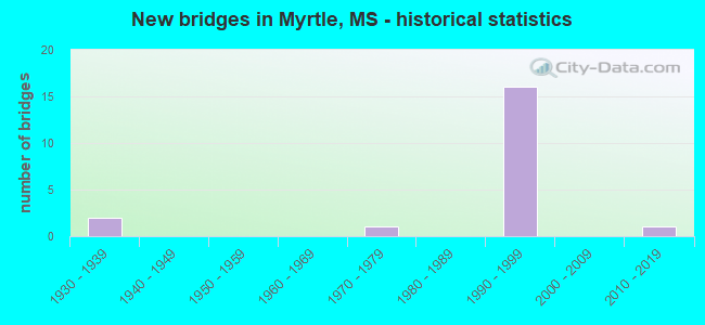
- New bridges - historical statistics
- 21930-1939
- 11970-1979
- 161990-1999
- 12010-2019


- Bridge Condition - Deck
- 7.1%Very good
- 57.1%Good
- 35.7%Satisfactory

- Bridge Condition - Superstructure
- 28.6%Very good
- 42.9%Good
- 7.1%Satisfactory
- 21.4%Fair

- Bridge Condition - Substructure
- 7.1%Very good
- 57.1%Good
- 21.4%Satisfactory
- 7.1%Fair
- 7.1%Serious

- Bridge Condition - Channel
- 7.1%Very good
- 57.1%Good
- 28.6%Satisfactory
- 7.1%Fair
Find on map >> Show street view
Structure Number: 21000780730553, Location: 1.8 MI E BENTON CL (Lat: 34.573225, Lng: -89.128619), Route carried "on" structure: State highway 178, Year Built: 1938, Status: Posted for load, Structure Length: 4.88m (16.01ft), Average Daily Traffic: 880 (year 2020), Truck Traffic: 11%, Average Future Daily Traffic: 880 (year 2040), Design Load: H 15, Features Intersected: W BRANCH
Minimum Vertical Clearance: 30+ m (98+ ft), Kilometerpoint: 2.881, Lanes on structure: 2, Owner: State Highway Agency, Approaching Roadway Width: 12.2m (40.0ft), Material/Design: Steel, Design/Construction: Stringer/Multi-beam, Number Of Spans In Main Unit: 8, Length of Maximum Span: 6.1m (20.0ft), Curb or Sidewalk Widths: Left: 0.2m (0.7ft), Right: 0.2m (0.7ft), Curb-To-Curb Width: 7.3m (24.0ft), Out-to-Out Width: 8.1m (26.6ft)
Condition: Deck: Satisfactory, Superstructure: Fair, Substructure: Serious, Channel: Satisfactory, Structural Evaluation: High priority of replacement, Deck Geometry: Meets minimum limits, Waterway Adequacy: Better than present minimum criteria, Approach Roadway Alignment: Equal to present desirable criteria, Bridge Posting: Required (Relationship of Operating Rating to Maximum Legal Load: 10.0 - 19.9% below), Length Of Structure Improvement: 6.31m (20.70ft), Designated Inspection Frequency: Every 12 months, Inspection Date: March 2021, Bridge Improvement Cost: $576,000,000, Roadway Improvement Cost: $58,000,000, Total Project Cost: $999,999,000, Deck Structure Type: Concrete Cast-file-Place, Wearing Surface/Protective System: Wearing Surface: Bituminous
Find on map >> Show street view
Structure Number: 21000780730568A, Location: 5.2 MI E BENTON CL (Lat: 34.548011, Lng: -89.119967), Route carried "on" structure: Interstate 22, Year Built: 1992, Status: Open, Structure Length: 7.11m (23.33ft), Average Daily Traffic: 11,000 (year 2020), Truck Traffic: 37%, Average Future Daily Traffic: 12,500 (year 2040), Design Load: HS 20, Features Intersected: LOCKS CREEK
Minimum Vertical Clearance: 30+ m (98+ ft), Kilometerpoint: 32.856, Lanes on structure: 2, Base Highway Network: Yes (Inventory Route: 2, Subroute: 1), Owner: State Highway Agency, Approaching Roadway Width: 13.4m (44.0ft), Skew: 14 degrees, Material/Design: Prestressed concrete continuous, Design/Construction: Stringer/Multi-beam, Number Of Spans In Main Unit: 3, Length of Maximum Span: 30.5m (100.1ft), Curb-To-Curb Width: 12.8m (42.0ft), Out-to-Out Width: 13.7m (44.9ft)
Condition: Deck: Satisfactory, Superstructure: Good, Substructure: Good, Channel: Good, Operating Rating: 57.2 metric tons, Method Used To Determine Operating Rating: Load Factor (LF), Inventory Rating: 24.5 metric tons, Method Used To Determine Inventory Rating: Load Factor (LF), Structural Evaluation: Equal to present minimum criteria, Deck Geometry: Equal to present desirable criteria, Waterway Adequacy: Equal to present desirable criteria, Approach Roadway Alignment: Equal to present desirable criteria, Designated Inspection Frequency: Every 24 months, Inspection Date: November 2021, Deck Structure Type: Concrete Cast-file-Place, Wearing Surface/Protective System: Wearing Surface: Low Slump Concrete
Find on map >> Show street view
Structure Number: 21000780730568B, Location: 5.2 MI E BENTON CL (Lat: 34.547933, Lng: -89.120461), Route carried "on" structure: Interstate 22, Year Built: 1992, Status: Open, Structure Length: 7.11m (23.33ft), Average Daily Traffic: 9,500 (year 2020), Truck Traffic: 41%, Average Future Daily Traffic: 10,500 (year 2040), Design Load: HS 20, Features Intersected: LOCKS CREEK
Minimum Vertical Clearance: 30+ m (98+ ft), Kilometerpoint: 8.314, Lanes on structure: 3, Base Highway Network: Yes (Inventory Route: 2, Subroute: 1), Owner: State Highway Agency, Approaching Roadway Width: 16.2m (53.1ft), Skew: 14 degrees, Material/Design: Prestressed concrete continuous, Design/Construction: Stringer/Multi-beam, Number Of Spans In Main Unit: 3, Length of Maximum Span: 30.5m (100.1ft), Curb-To-Curb Width: 16.1m (52.8ft), Out-to-Out Width: 17.0m (55.8ft)
Condition: Deck: Good, Superstructure: Good, Substructure: Good, Channel: Satisfactory, Operating Rating: 57.8 metric tons, Method Used To Determine Operating Rating: Load Factor (LF), Inventory Rating: 26.6 metric tons, Method Used To Determine Inventory Rating: Load Factor (LF), Structural Evaluation: Equal to present minimum criteria, Deck Geometry: Equal to present minimum criteria, Waterway Adequacy: Equal to present desirable criteria, Approach Roadway Alignment: Equal to present desirable criteria, Designated Inspection Frequency: Every 24 months, Inspection Date: November 2021, Deck Structure Type: Concrete Cast-file-Place
Find on map >> Show street view
Structure Number: 21000780730584, Location: 4.8 MI E BENTON CL (Lat: 34.539947, Lng: -89.094206), Route carried "on" structure: State highway 178, Year Built: 1938, Status: Open, Structure Length: 4.57m (14.99ft), Average Daily Traffic: 2,600 (year 2020), Truck Traffic: 6%, Average Future Daily Traffic: 2,600 (year 2040), Design Load: H 15, Features Intersected: MUD CREEK
Minimum Vertical Clearance: 30+ m (98+ ft), Kilometerpoint: 7.897, Lanes on structure: 2, Owner: State Highway Agency, Approaching Roadway Width: 9.8m (32.2ft), Material/Design: Steel, Design/Construction: Stringer/Multi-beam, Number Of Spans In Main Unit: 5, Length of Maximum Span: 9.1m (29.9ft), Curb or Sidewalk Widths: Left: 0.2m (0.7ft), Right: 0.2m (0.7ft), Curb-To-Curb Width: 7.3m (24.0ft), Out-to-Out Width: 8.1m (26.6ft)
Condition: Deck: Satisfactory, Superstructure: Fair, Substructure: Fair, Channel: Satisfactory, Operating Rating: 45.7 metric tons, Method Used To Determine Operating Rating: Load Factor (LF), Inventory Rating: 27.4 metric tons, Method Used To Determine Inventory Rating: Load Factor (LF), Structural Evaluation: Somewhat better than minimum adequacy, Deck Geometry: High priority of replacement, Waterway Adequacy: Better than present minimum criteria, Approach Roadway Alignment: Equal to present desirable criteria, Length Of Structure Improvement: 5.91m (19.39ft), Designated Inspection Frequency: Every 24 months, Inspection Date: August 2021, Bridge Improvement Cost: $533,000,000, Roadway Improvement Cost: $53,000,000, Total Project Cost: $999,999,000, Deck Structure Type: Concrete Cast-file-Place, Wearing Surface/Protective System: Wearing Surface: Bituminous
Find on map >> Show street view
Structure Number: 21000780730586A, Location: 7.0 MI E BENTON CL (Lat: 34.536850, Lng: -89.091839), Route carried "on" structure: Interstate 22, Year Built: 1992, Status: Open, Structure Length: 5.84m (19.16ft), Average Daily Traffic: 11,000 (year 2020), Truck Traffic: 37%, Average Future Daily Traffic: 12,500 (year 2040), Design Load: HS 20, Features Intersected: LITTLE MUD CREEK
Minimum Vertical Clearance: 30+ m (98+ ft), Kilometerpoint: 29.990, Lanes on structure: 2, Base Highway Network: Yes (Inventory Route: 2, Subroute: 1), Owner: State Highway Agency, Approaching Roadway Width: 13.4m (44.0ft), Skew: 10 degrees, Material/Design: Prestressed concrete, Design/Construction: Stringer/Multi-beam, Number Of Spans In Main Unit: 1, Number Of Approach Spans: 2, Length of Maximum Span: 33.5m (109.9ft), Curb-To-Curb Width: 12.8m (42.0ft), Out-to-Out Width: 13.7m (44.9ft)
Condition: Deck: Good, Superstructure: Very good, Substructure: Satisfactory, Channel: Good, Operating Rating: 62.4 metric tons, Method Used To Determine Operating Rating: Load Factor (LF), Inventory Rating: 28.8 metric tons, Method Used To Determine Inventory Rating: Load Factor (LF), Structural Evaluation: Equal to present minimum criteria, Deck Geometry: Equal to present desirable criteria, Waterway Adequacy: Equal to present desirable criteria, Approach Roadway Alignment: Equal to present desirable criteria, Designated Inspection Frequency: Every 24 months, Inspection Date: November 2021, Deck Structure Type: Concrete Cast-file-Place
Find on map >> Show street view
Structure Number: 21000780730586B, Location: 7.0 MI E BENTON CL (Lat: 34.536919, Lng: -89.092500), Route carried "on" structure: Interstate 22, Year Built: 1992, Status: Open, Structure Length: 5.84m (19.16ft), Average Daily Traffic: 11,000 (year 2020), Truck Traffic: 37%, Average Future Daily Traffic: 12,500 (year 2040), Design Load: HS 20, Features Intersected: LITTLE MUD CREEK
Minimum Vertical Clearance: 30+ m (98+ ft), Kilometerpoint: 11.159, Lanes on structure: 2, Base Highway Network: Yes (Inventory Route: 2, Subroute: 1), Owner: State Highway Agency, Approaching Roadway Width: 13.4m (44.0ft), Skew: 10 degrees, Material/Design: Prestressed concrete, Design/Construction: Stringer/Multi-beam, Number Of Spans In Main Unit: 1, Number Of Approach Spans: 2, Length of Maximum Span: 33.5m (109.9ft), Curb-To-Curb Width: 12.8m (42.0ft), Out-to-Out Width: 13.7m (44.9ft)
Condition: Deck: Good, Superstructure: Good, Substructure: Good, Channel: Good, Operating Rating: 62.4 metric tons, Method Used To Determine Operating Rating: Load Factor (LF), Inventory Rating: 28.9 metric tons, Method Used To Determine Inventory Rating: Load Factor (LF), Structural Evaluation: Better than present minimum criteria, Deck Geometry: Equal to present desirable criteria, Waterway Adequacy: Equal to present desirable criteria, Approach Roadway Alignment: Equal to present desirable criteria, Designated Inspection Frequency: Every 24 months, Inspection Date: November 2021, Deck Structure Type: Concrete Cast-file-Place
Find on map >> Show street view
Structure Number: 41000780730564, Location: 4.8 MI E BENTON CL (Lat: 34.549664, Lng: -89.126086), Route carried "on" structure: County highway , Year Built: 1993, Status: Open, Structure Length: 10.13m (33.23ft), Average Daily Traffic: 170 (year 2020), Truck Traffic: 13%, Average Future Daily Traffic: 170 (year 2040), Design Load: HS 20, Features Intersected: I 22, Facility Carried by Structure: COUNTY ROAD 515
Minimum Vertical Clearance: 30+ m (98+ ft), Kilometerpoint: 14.061, Lanes on structure: 3, Lanes under structure: 4, Owner: State Highway Agency, Approaching Roadway Width: 15.8m (51.8ft), Skew: 1 degrees, Material/Design: Prestressed concrete continuous, Design/Construction: Stringer/Multi-beam, Number Of Spans In Main Unit: 4, Length of Maximum Span: 27.7m (90.9ft), Curb-To-Curb Width: 15.9m (52.2ft), Out-to-Out Width: 16.7m (54.8ft)
Condition: Deck: Good, Superstructure: Very good, Substructure: Good, Operating Rating: 52.7 metric tons, Method Used To Determine Operating Rating: Load Factor (LF), Inventory Rating: 24.3 metric tons, Method Used To Determine Inventory Rating: Load Factor (LF), Structural Evaluation: Equal to present minimum criteria, Deck Geometry: Better than present minimum criteria, Underclear: Better than present minimum criteria, Approach Roadway Alignment: Equal to present desirable criteria, Designated Inspection Frequency: Every 24 months, Inspection Date: November 2021, Deck Structure Type: Concrete Cast-file-Place
Find on map >> Show street view
Structure Number: 41000780730577, Location: 6.1 MI E BENTON CL (Lat: 34.541917, Lng: -89.105269), Route carried "on" structure: County highway , Year Built: 1993, Status: Open, Structure Length: 10.26m (33.66ft), Average Daily Traffic: 950 (year 2020), Truck Traffic: 5%, Average Future Daily Traffic: 950 (year 2040), Design Load: HS 20, Features Intersected: I 22, Facility Carried by Structure: COUNTY ROAD 51
Minimum Vertical Clearance: 30+ m (98+ ft), Kilometerpoint: 9.027, Lanes on structure: 2, Lanes under structure: 4, Owner: State Highway Agency, Approaching Roadway Width: 9.8m (32.2ft), Skew: 2 degrees, Material/Design: Prestressed concrete continuous, Design/Construction: Stringer/Multi-beam, Number Of Spans In Main Unit: 4, Length of Maximum Span: 29.9m (98.1ft), Curb-To-Curb Width: 9.8m (32.2ft), Out-to-Out Width: 10.6m (34.8ft)
Condition: Deck: Good, Superstructure: Very good, Substructure: Good, Operating Rating: 57.6 metric tons, Method Used To Determine Operating Rating: Load Factor (LF), Inventory Rating: 26.2 metric tons, Method Used To Determine Inventory Rating: Load Factor (LF), Structural Evaluation: Equal to present minimum criteria, Deck Geometry: Equal to present minimum criteria, Underclear: Equal to present desirable criteria, Approach Roadway Alignment: Equal to present desirable criteria, Designated Inspection Frequency: Every 24 months, Inspection Date: November 2021, Deck Structure Type: Concrete Cast-file-Place
Find on map >> Show street view
Structure Number: SA730000000001, Location: SEC 16 T 6S R 2E B (Lat: 34.561997, Lng: -89.099111), Route carried "on" structure: County highway 461, Year Built: 1999, Status: Open, Structure Length: 2.10m (6.89ft), Average Daily Traffic: 175 (year 2018), Truck Traffic: 8%, Average Future Daily Traffic: 263 (year 2038), Design Load: HS 20, Features Intersected: AYERS CREEK, Facility Carried by Structure: CO. RD. 69
Minimum Vertical Clearance: 30+ m (98+ ft), Kilometerpoint: 7.724, Lanes on structure: 2, Owner: County Highway Agency, Approaching Roadway Width: 9.0m (29.5ft), Material/Design: Concrete, Design/Construction: Channel Beam, Number Of Spans In Main Unit: 3, Length of Maximum Span: 5.8m (19.0ft), Curb-To-Curb Width: 8.5m (27.9ft), Out-to-Out Width: 9.3m (30.5ft)
Condition: Deck: Good, Superstructure: Good, Substructure: Good, Channel: Good, Operating Rating: 62.5 metric tons, Method Used To Determine Operating Rating: Load Factor (LF) rating reported by rating factor (RF) method using MS18 loading, Inventory Rating: 37.6 metric tons, Method Used To Determine Inventory Rating: Load Factor (LF) rating reported by rating factor (RF) method using MS18 loading, Structural Evaluation: Better than present minimum criteria, Deck Geometry: Equal to present minimum criteria, Waterway Adequacy: Equal to present desirable criteria, Approach Roadway Alignment: Equal to present desirable criteria, Designated Inspection Frequency: Every 24 months, Inspection Date: November 2020, Deck Structure Type: Concrete Cast-file-Place, Wearing Surface/Protective System: Wearing Surface: Monolithic Concrete
Find on map >> Show street view
Structure Number: SA7300000000011, Location: SEC 18 T 6S R 2E B (Lat: 34.556244, Lng: -89.124467), Route carried "on" structure: City street 756, Year Built: 1991, Status: Open, Structure Length: 5.79m (19.00ft), Average Daily Traffic: 500 (year 2018), Truck Traffic: 8%, Average Future Daily Traffic: 750 (year 2038), Design Load: HS 20, Features Intersected: LOCKES CREEK, Facility Carried by Structure: WILLOW DRIVE
Minimum Vertical Clearance: 30+ m (98+ ft), Kilometerpoint: 0.482, Lanes on structure: 2, Owner: City or Municipal Highway Agency, Approaching Roadway Width: 9.8m (32.2ft), Skew: 4 degrees, Material/Design: Prestressed concrete, Design/Construction: Stringer/Multi-beam, Number Of Spans In Main Unit: 3, Length of Maximum Span: 27.4m (89.9ft), Curb-To-Curb Width: 9.8m (32.2ft), Out-to-Out Width: 10.6m (34.8ft)
Condition: Deck: Good, Superstructure: Very good, Substructure: Very good, Channel: Fair, Operating Rating: 43.2 metric tons, Method Used To Determine Operating Rating: Allowable Stress (AS), Inventory Rating: 32.4 metric tons, Method Used To Determine Inventory Rating: Allowable Stress (AS), Structural Evaluation: Equal to present desirable criteria, Deck Geometry: Equal to present minimum criteria, Waterway Adequacy: Equal to present desirable criteria, Approach Roadway Alignment: Equal to present desirable criteria, Length Of Structure Improvement: 6.84m (22.44ft), Designated Inspection Frequency: Every 24 months, Inspection Date: November 2020, Deck Structure Type: Concrete Cast-file-Place, Wearing Surface/Protective System: Wearing Surface: Monolithic Concrete
Find on map >> Show street view
Structure Number: SA7300000000016, Location: SEC 32 T 6S R 2E (Lat: 34.523892, Lng: -89.115883), Route carried "on" structure: County highway 162, Year Built: 1997, Status: Open, Structure Length: 3.63m (11.91ft), Average Daily Traffic: 125 (year 2018), Truck Traffic: 8%, Average Future Daily Traffic: 188 (year 2038), Design Load: HS 20, Features Intersected: LOCKES CREEK, Facility Carried by Structure: COUNTY ROAD 54
Minimum Vertical Clearance: 30+ m (98+ ft), Kilometerpoint: 1.126, Lanes on structure: 2, Owner: County Highway Agency, Approaching Roadway Width: 8.5m (27.9ft), Material/Design: Prestressed concrete, Design/Construction: Stringer/Multi-beam, Number Of Spans In Main Unit: 5, Length of Maximum Span: 9.4m (30.8ft), Curb or Sidewalk Widths: Left: 0.2m (0.7ft), Right: 0.2m (0.7ft), Curb-To-Curb Width: 7.9m (25.9ft), Out-to-Out Width: 8.3m (27.2ft)
Condition: Deck: Very good, Superstructure: Good, Substructure: Good, Channel: Good, Operating Rating: 75.5 metric tons, Method Used To Determine Operating Rating: Load Factor (LF) rating reported by rating factor (RF) method using MS18 loading, Inventory Rating: 15.2 metric tons, Method Used To Determine Inventory Rating: Load Factor (LF) rating reported by rating factor (RF) method using MS18 loading, Structural Evaluation: Meets minimum limits, Deck Geometry: Somewhat better than minimum adequacy, Waterway Adequacy: Equal to present minimum criteria, Approach Roadway Alignment: Equal to present minimum criteria, Length Of Structure Improvement: 4.65m (15.26ft), Designated Inspection Frequency: Every 24 months, Inspection Date: November 2020, Bridge Improvement Cost: $644,000, Roadway Improvement Cost: $100,000, Total Project Cost: $966,000 ( Estimate for 2020), Deck Structure Type: Concrete Cast-file-Place, Wearing Surface/Protective System: Wearing Surface: Monolithic Concrete
Find on map >> Show street view
Structure Number: SA7300000000077, Location: SEC 6 T 7S R 2E B (Lat: 34.499950, Lng: -89.135878), Route carried "on" structure: County highway 163, Year Built: 1999, Year Reconstructed: 2011, Status: Posted for load, Structure Length: 1.83m (6.00ft), Average Daily Traffic: 75 (year 2014), Average Future Daily Traffic: 113 (year 2034), Features Intersected: DRAINAGE DITCH, Facility Carried by Structure: COUNTY ROAD 515
Minimum Vertical Clearance: 30+ m (98+ ft), Kilometerpoint: 7.402, Lanes on structure: 2, Owner: County Highway Agency, Approaching Roadway Width: 5.8m (19.0ft), Material/Design: Steel, Design/Construction: Stringer/Multi-beam, Number Of Spans In Main Unit: 1, Length of Maximum Span: 16.6m (54.5ft), Curb-To-Curb Width: 7.9m (25.9ft), Out-to-Out Width: 7.9m (25.9ft)
Condition: Deck: Satisfactory, Superstructure: Satisfactory, Substructure: Satisfactory, Channel: Good, Operating Rating: 16.7 metric tons, Method Used To Determine Operating Rating: Load Factor (LF), Inventory Rating: 10.0 metric tons, Method Used To Determine Inventory Rating: Load Factor (LF), Structural Evaluation: High priority of replacement, Deck Geometry: Equal to present minimum criteria, Waterway Adequacy: Equal to present desirable criteria, Approach Roadway Alignment: High priority of corrective action, Bridge Posting: Required (Relationship of Operating Rating to Maximum Legal Load: > 39.9% below), Length Of Structure Improvement: 1.83m (6.00ft), Designated Inspection Frequency: Every 24 months, Inspection Date: June 2021, Bridge Improvement Cost: $59,000, Roadway Improvement Cost: $130,000, Total Project Cost: $237,000, Deck Structure Type: Concrete Cast-file-Place
Find on map >> Show street view
Structure Number: SA7300000000078, Location: SEC 6 T 7S R 2E (Lat: 34.500083, Lng: -89.126833), Route carried "on" structure: County highway 167, Year Built: 1973, Status: Posted for load, Structure Length: 4.21m (13.81ft), Average Daily Traffic: 50 (year 2013), Truck Traffic: 8%, Average Future Daily Traffic: 75 (year 2035), Features Intersected: LOCKES CREEK, Facility Carried by Structure: COUNTY ROAD 50
Minimum Vertical Clearance: 30+ m (98+ ft), Kilometerpoint: 0.965, Lanes on structure: 2, Owner: County Highway Agency, Approaching Roadway Width: 5.2m (17.1ft), Skew: 1 degrees, Material/Design: Steel, Design/Construction: Girder and Floorbeam System, Number Of Spans In Main Unit: 1, Number Of Approach Spans: 4, Length of Maximum Span: 15.2m (49.9ft), Curb-To-Curb Width: 7.0m (23.0ft), Out-to-Out Width: 7.0m (23.0ft)
Condition: Deck: Satisfactory, Superstructure: Fair, Substructure: Satisfactory, Channel: Satisfactory, Operating Rating: 3.6 metric tons, Method Used To Determine Operating Rating: Load Factor (LF), Inventory Rating: 2.5 metric tons, Method Used To Determine Inventory Rating: Load Factor (LF), Structural Evaluation: High priority of replacement, Deck Geometry: Somewhat better than minimum adequacy, Waterway Adequacy: Better than present minimum criteria, Approach Roadway Alignment: High priority of corrective action, Bridge Posting: Required (Relationship of Operating Rating to Maximum Legal Load: > 39.9% below), Length Of Structure Improvement: 4.88m (16.01ft), Designated Inspection Frequency: Every 12 months, Inspection Date: November 2021, Bridge Improvement Cost: $142,000, Roadway Improvement Cost: $200,000, Total Project Cost: $455,000, Deck Structure Type: Concrete Cast-file-Place, Wearing Surface/Protective System: Wearing Surface: Monolithic Concrete
Find on map >> Show street view
Structure Number: SA7300000000151, Location: SEC 16 T 6S R 2E B (Lat: 34.562050, Lng: -89.092125), Route carried "on" structure: County highway 461, Year Built: 1999, Status: Open, Structure Length: 0.75m (2.46ft), Average Daily Traffic: 175 (year 2020), Truck Traffic: 10%, Average Future Daily Traffic: 263 (year 2040), Design Load: HS 20, Features Intersected: BEULAH CREEK, Facility Carried by Structure: COUNTY ROAD 69
Minimum Vertical Clearance: 30+ m (98+ ft), Kilometerpoint: 7.724, Lanes on structure: 2, Owner: County Highway Agency, Approaching Roadway Width: 9.0m (29.5ft), Material/Design: Concrete, Design/Construction: Culvert, Number Of Spans In Main Unit: 2, Length of Maximum Span: 3.8m (12.5ft)
Condition: Channel: Good, Culverts: Good, Operating Rating: 69.0 metric tons, Method Used To Determine Operating Rating: Load Factor (LF) rating reported by rating factor (RF) method using MS18 loading, Inventory Rating: 41.5 metric tons, Method Used To Determine Inventory Rating: Load Factor (LF) rating reported by rating factor (RF) method using MS18 loading, Structural Evaluation: Better than present minimum criteria, Waterway Adequacy: Equal to present desirable criteria, Approach Roadway Alignment: Equal to present desirable criteria, Designated Inspection Frequency: Every 24 months, Inspection Date: November 2021
Find on map >> Show street view
Structure Number: SA7300000000152, Location: SEC 16 T 6S R 2E B (Lat: 34.562131, Lng: -89.074447), Route carried "on" structure: County highway 461, Year Built: 1999, Status: Open, Structure Length: 0.65m (2.13ft), Average Daily Traffic: 175 (year 2020), Truck Traffic: 10%, Average Future Daily Traffic: 263 (year 2040), Design Load: HS 20, Features Intersected: NOVELL CREEK, Facility Carried by Structure: COUNTY ROAD 69
Minimum Vertical Clearance: 30+ m (98+ ft), Kilometerpoint: 7.724, Lanes on structure: 2, Owner: County Highway Agency, Approaching Roadway Width: 9.0m (29.5ft), Skew: 1 degrees, Material/Design: Concrete, Design/Construction: Culvert, Number Of Spans In Main Unit: 2, Length of Maximum Span: 3.2m (10.5ft)
Condition: Channel: Good, Culverts: Good, Operating Rating: 66.1 metric tons, Method Used To Determine Operating Rating: Load Factor (LF) rating reported by rating factor (RF) method using MS18 loading, Inventory Rating: 39.5 metric tons, Method Used To Determine Inventory Rating: Load Factor (LF) rating reported by rating factor (RF) method using MS18 loading, Structural Evaluation: Better than present minimum criteria, Waterway Adequacy: Equal to present desirable criteria, Approach Roadway Alignment: Equal to present desirable criteria, Designated Inspection Frequency: Every 24 months, Inspection Date: November 2021
Find on map >> Show street view
Structure Number: SA7300000000156, Location: SEC 22 T 6S R 2E (Lat: 34.547492, Lng: -89.071472), Route carried "on" structure: County highway 142, Year Built: 2011, Status: Open, Structure Length: 1.83m (6.00ft), Average Daily Traffic: 350 (year 2018), Truck Traffic: 8%, Average Future Daily Traffic: 525 (year 2038), Features Intersected: NOVELL CREEK, Facility Carried by Structure: COUNTY ROAD 478
Minimum Vertical Clearance: 30+ m (98+ ft), Kilometerpoint: 4.184, Lanes on structure: 2, Owner: County Highway Agency, Approaching Roadway Width: 5.7m (18.7ft), Material/Design: Steel, Design/Construction: Stringer/Multi-beam, Number Of Spans In Main Unit: 3, Length of Maximum Span: 9.1m (29.9ft), Curb-To-Curb Width: 7.1m (23.3ft), Out-to-Out Width: 7.6m (24.9ft)
Condition: Deck: Good, Superstructure: Good, Substructure: Good, Channel: Very good, Operating Rating: 54.1 metric tons, Method Used To Determine Operating Rating: Load Factor (LF) rating reported by rating factor (RF) method using MS18 loading, Inventory Rating: 32.4 metric tons, Method Used To Determine Inventory Rating: Load Factor (LF) rating reported by rating factor (RF) method using MS18 loading, Structural Evaluation: Better than present minimum criteria, Deck Geometry: Meets minimum limits, Waterway Adequacy: Superior to present desirable criteria, Approach Roadway Alignment: Equal to present desirable criteria, Length Of Structure Improvement: 2.10m (6.89ft), Designated Inspection Frequency: Every 24 months, Inspection Date: November 2020, Bridge Improvement Cost: $188,000, Roadway Improvement Cost: $36,000, Total Project Cost: $282,000 ( Estimate for 2020), Deck Structure Type: Concrete Cast-file-Place
Find on map >> Show street view
Structure Number: 41000780730564, Location: 4.8 MI E BENTON CL (Lat: 34.550250, Lng: -89.125969), Route carried "under" structure: Interstate 22, Year Built: 1993, Structure Length: 0. m, Average Daily Traffic: 11,000 (year 2017), Truck Traffic: 8%, Features Intersected: I 22, Facility Carried by Structure: COUNTY ROAD 515
Minimum Vertical Clearance: 5.12m (16.80ft), Kilometerpoint: 33.461, Lanes on structure: 3, Lanes under structure: 4, Material/Design: Prestressed concrete continuous, Design/Construction: Stringer/Multi-beam, Length of Maximum Span: 28.0m (91.9ft)
Find on map >> Show street view
Structure Number: 41000780730564, Location: 4.8 MI E BENTON CL (Lat: 34.550011, Lng: -89.126019), Route carried "under" structure: Interstate 22, Year Built: 1993, Structure Length: 0. m, Average Daily Traffic: 11,000 (year 2017), Truck Traffic: 8%, Features Intersected: I 22, Facility Carried by Structure: COUNTY ROAD 515
Minimum Vertical Clearance: 6.07m (19.91ft), Kilometerpoint: 7.754, Lanes on structure: 3, Lanes under structure: 4, Material/Design: Prestressed concrete continuous, Design/Construction: Stringer/Multi-beam, Length of Maximum Span: 28.0m (91.9ft)
Find on map >> Show street view
Structure Number: 41000780730577, Location: 6.1 MI E BENTON CL (Lat: 34.542539, Lng: -89.105281), Route carried "under" structure: Interstate 22, Year Built: 1993, Structure Length: 0. m, Average Daily Traffic: 8,500 (year 2017), Truck Traffic: 8%, Features Intersected: I 22, Facility Carried by Structure: COUNTY ROAD 51
Minimum Vertical Clearance: 5.18m (16.99ft), Kilometerpoint: 31.379, Lanes on structure: 2, Lanes under structure: 4, Material/Design: Prestressed concrete continuous, Design/Construction: Stringer/Multi-beam, Length of Maximum Span: 29.9m (98.1ft)
Find on map >> Show street view
Structure Number: 41000780730577, Location: 6.1 MI E BENTON CL (Lat: 34.542269, Lng: -89.105269), Route carried "under" structure: Interstate 22, Year Built: 1993, Structure Length: 0. m, Average Daily Traffic: 8,500 (year 2017), Truck Traffic: 8%, Features Intersected: I 22, Facility Carried by Structure: COUNTY ROAD 51
Minimum Vertical Clearance: 5.82m (19.09ft), Kilometerpoint: 9.843, Lanes on structure: 2, Lanes under structure: 4, Material/Design: Prestressed concrete continuous, Design/Construction: Stringer/Multi-beam, Length of Maximum Span: 29.9m (98.1ft)