Bridge Statistics for Norco, California (CA)
Condition, Traffic, Stress, Structural Evaluation, Project Costs
- National Bridge Inventory (NBI) Statistics
- 32Number of bridges
- 955ft / 291mTotal length
- $3,892,000Total costs
- 1,381,171Total average daily traffic
- 121,311Total average daily truck traffic
- National Bridge Inventory (NBI) Registered Bridges for Norco
- No street view available for this location
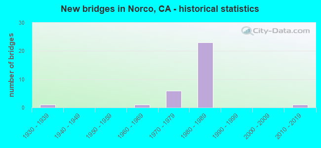
- New bridges - historical statistics
- 11930-1939
- 11960-1969
- 61970-1979
- 231980-1989
- 12010-2019


- Bridge Condition - Deck
- 69.6%Good
- 26.1%Fair
- 4.3%Poor

- Bridge Condition - Superstructure
- 60.9%Good
- 39.1%Fair

- Bridge Condition - Substructure
- 65.2%Good
- 4.3%Satisfactory
- 30.4%Fair

- Bridge Condition - Channel
- 64.3%Excellent
- 28.6%Very good
- 7.1%Good

- Bridge Condition - Culverts
- 50.0%Good
- 50.0%Satisfactory
Find on map >> Show street view
Structure Number: 56 053, Location: 08-RIV-010-R24.55 (Lat: 33.924247, Lng: -116.689381), Route carried "on" structure: County highway , Year Built: 1966, Status: Open, Structure Length: 8.38m (27.49ft), Average Daily Traffic: 750 (year 2012), Truck Traffic: 2%, Average Future Daily Traffic: 1,000 (year 2037), Design Load: HS 20, Features Intersected: INTERSTATE 10 & WB RAMP, Facility Carried by Structure: VERBENIA AVE
Minimum Vertical Clearance: 30+ m (98+ ft), Kilometerpoint: 0.000, Lanes on structure: 2, Lanes under structure: 9, Base Highway Network: Yes, Owner: State Highway Agency, Approaching Roadway Width: 9.8m (32.2ft), Material/Design: Concrete continuous, Design/Construction: Box Beam or Girders - Multiple, Number Of Spans In Main Unit: 3, Length of Maximum Span: 32.0m (105.0ft), Curb-To-Curb Width: 9.8m (32.2ft), Out-to-Out Width: 10.4m (34.1ft)
Condition: Deck: Good, Superstructure: Good, Substructure: Fair, Operating Rating: 41.8 metric tons, Method Used To Determine Operating Rating: Load and Resistance Factor Rating (LRFR) rating reported by rating factor(RF) method using HL-93 loadings, Inventory Rating: 32.4 metric tons, Method Used To Determine Inventory Rating: Load and Resistance Factor Rating (LRFR) rating reported by rating factor(RF) method using HL-93 loadings, Structural Evaluation: Somewhat better than minimum adequacy, Deck Geometry: Equal to present minimum criteria, Underclear: Meets minimum limits, Approach Roadway Alignment: Equal to present desirable criteria, Designated Inspection Frequency: Every 24 months, Inspection Date: October 2020, Deck Structure Type: Concrete Cast-file-Place, Wearing Surface/Protective System: Wearing Surface: Bituminous
Find on map >> Show street view
Structure Number: 56 0536L, Location: 08-RIV-015-46.16-NRCO (Lat: 33.945842, Lng: -117.554947), Route carried "on" structure: Interstate 15, Year Built: 1988, Status: Open, Structure Length: 55.76m (182.94ft), Average Daily Traffic: 75,000 (year 2012), Truck Traffic: 11%, Average Future Daily Traffic: 104,800 (year 2038), Design Load: HS 20+Mod, Features Intersected: SANTA ANA RIVER
Minimum Vertical Clearance: 30+ m (98+ ft), Kilometerpoint: 46.160, Lanes on structure: 3, Base Highway Network: Yes (, Subroute: 1), Owner: State Highway Agency, Approaching Roadway Width: 16.2m (53.1ft), Skew: 9 degrees, Material/Design: Prestressed concrete continuous, Design/Construction: Box Beam or Girders - Multiple, Number Of Spans In Main Unit: 11, Length of Maximum Span: 53.0m (173.9ft), Curb-To-Curb Width: 16.2m (53.1ft), Out-to-Out Width: 17.3m (56.8ft)
Condition: Deck: Good, Superstructure: Good, Substructure: Good, Channel: Very good, Operating Rating: 54.1 metric tons, Method Used To Determine Operating Rating: Assigned rating based on Load Factor Design (LFD) reported in metric tons, Inventory Rating: 32.4 metric tons, Method Used To Determine Inventory Rating: Assigned rating based on Load Factor Design (LFD) reported in metric tons, Structural Evaluation: Better than present minimum criteria, Deck Geometry: Equal to present minimum criteria, Waterway Adequacy: Equal to present desirable criteria, Approach Roadway Alignment: Equal to present desirable criteria, Designated Inspection Frequency: Every 24 months, Inspection Date: April 2020, Deck Structure Type: Concrete Cast-file-Place
Find on map >> Show street view
Structure Number: 56 0536R, Location: 08-RIV-015-46.16-NRCO (Lat: 33.945956, Lng: -117.554533), Route carried "on" structure: Interstate 15, Year Built: 1988, Status: Open, Structure Length: 55.76m (182.94ft), Average Daily Traffic: 75,000 (year 2012), Truck Traffic: 11%, Average Future Daily Traffic: 104,800 (year 2038), Design Load: HS 20+Mod, Features Intersected: SANTA ANA RIVER
Minimum Vertical Clearance: 30+ m (98+ ft), Kilometerpoint: 46.160, Lanes on structure: 3, Base Highway Network: Yes (, Subroute: 1), Owner: State Highway Agency, Approaching Roadway Width: 16.2m (53.1ft), Skew: 9 degrees, Material/Design: Prestressed concrete continuous, Design/Construction: Box Beam or Girders - Multiple, Number Of Spans In Main Unit: 11, Length of Maximum Span: 53.0m (173.9ft), Curb-To-Curb Width: 16.2m (53.1ft), Out-to-Out Width: 17.3m (56.8ft)
Condition: Deck: Good, Superstructure: Good, Substructure: Good, Channel: Very good, Operating Rating: 54.1 metric tons, Method Used To Determine Operating Rating: Assigned rating based on Load Factor Design (LFD) reported in metric tons, Inventory Rating: 32.4 metric tons, Method Used To Determine Inventory Rating: Assigned rating based on Load Factor Design (LFD) reported in metric tons, Structural Evaluation: Better than present minimum criteria, Deck Geometry: Equal to present minimum criteria, Waterway Adequacy: Equal to present desirable criteria, Approach Roadway Alignment: Equal to present desirable criteria, Designated Inspection Frequency: Every 24 months, Inspection Date: April 2020, Deck Structure Type: Concrete Cast-file-Place
Find on map >> Show street view
Structure Number: 56 066, Location: 08-RIV-060-R4.55 (Lat: 34.019522, Lng: -117.480650), Route carried "on" structure: County highway R166, Year Built: 1975, Status: Open, Structure Length: 8.05m (26.41ft), Average Daily Traffic: 19,500 (year 2016), Truck Traffic: 9%, Average Future Daily Traffic: 20,471 (year 2038), Design Load: HS 20+Mod, Features Intersected: STATE ROUTE 60, Facility Carried by Structure: PEDLEY ROAD
Minimum Vertical Clearance: 30+ m (98+ ft), Kilometerpoint: 0.000, Lanes on structure: 2, Lanes under structure: 10, Owner: State Highway Agency, Approaching Roadway Width: 15.5m (50.9ft), Skew: 2 degrees, Material/Design: Prestressed concrete continuous, Design/Construction: Box Beam or Girders - Multiple, Number Of Spans In Main Unit: 2, Length of Maximum Span: 41.1m (134.8ft), Curb or Sidewalk Widths: Left: 1.5m (4.9ft), Right: 0.0m, Curb-To-Curb Width: 15.5m (50.9ft), Out-to-Out Width: 17.7m (58.1ft)
Condition: Deck: Good, Superstructure: Good, Substructure: Good, Operating Rating: 55.1 metric tons, Method Used To Determine Operating Rating: Load and Resistance Factor Rating (LRFR) rating reported by rating factor(RF) method using HL-93 loadings, Inventory Rating: 41.5 metric tons, Method Used To Determine Inventory Rating: Load and Resistance Factor Rating (LRFR) rating reported by rating factor(RF) method using HL-93 loadings, Structural Evaluation: Better than present minimum criteria, Deck Geometry: Superior to present desirable criteria, Underclear: Equal to present minimum criteria, Approach Roadway Alignment: Equal to present desirable criteria, Designated Inspection Frequency: Every 24 months, Inspection Date: December 2021, Deck Structure Type: Concrete Cast-file-Place
Find on map >> Show street view
Structure Number: 56 0665, Location: 08-RIV-015-42.88-NRCO (Lat: 33.898375, Lng: -117.560228), Route carried "on" structure: City street , Year Built: 1989, Year Reconstructed: 1997, Status: Open, Structure Length: 8.78m (28.81ft), Average Daily Traffic: 6,914 (year 2016), Truck Traffic: 1%, Average Future Daily Traffic: 7,994 (year 2037), Design Load: HS 20+Mod, Features Intersected: INTERSTATE 15, Facility Carried by Structure: HIDDEN VALLEY PKWY
Minimum Vertical Clearance: 30+ m (98+ ft), Kilometerpoint: 0.000, Lanes on structure: 5, Lanes under structure: 8, Owner: State Highway Agency, Approaching Roadway Width: 31.1m (102.0ft), Skew: 2 degrees, Material/Design: Prestressed concrete continuous, Design/Construction: Box Beam or Girders - Multiple, Number Of Spans In Main Unit: 2, Length of Maximum Span: 45.2m (148.3ft), Curb or Sidewalk Widths: Left: 0.0m, Right: 1.5m (4.9ft), Curb-To-Curb Width: 31.1m (102.0ft), Out-to-Out Width: 34.3m (112.5ft)
Condition: Deck: Good, Superstructure: Fair, Substructure: Fair, Operating Rating: 54.1 metric tons, Method Used To Determine Operating Rating: Assigned rating based on Load Factor Design (LFD) reported in metric tons, Inventory Rating: 32.4 metric tons, Method Used To Determine Inventory Rating: Assigned rating based on Load Factor Design (LFD) reported in metric tons, Structural Evaluation: Somewhat better than minimum adequacy, Deck Geometry: Superior to present desirable criteria, Underclear: Equal to present minimum criteria, Approach Roadway Alignment: Superior to present desirable criteria, Designated Inspection Frequency: Every 24 months, Inspection Date: March 2020, Deck Structure Type: Concrete Cast-file-Place
Find on map >> Show street view
Structure Number: 56 0667L, Location: 08-RIV-015-43.64-NRCO (Lat: 33.909531, Lng: -117.558814), Route carried "on" structure: Interstate 15, Year Built: 1989, Status: Open, Structure Length: 4.34m (14.24ft), Average Daily Traffic: 75,000 (year 2012), Truck Traffic: 11%, Average Future Daily Traffic: 106,040 (year 2037), Design Load: HS 20+Mod, Features Intersected: SECOND STREET
Minimum Vertical Clearance: 30+ m (98+ ft), Kilometerpoint: 43.640, Lanes on structure: 3, Lanes under structure: 4, Base Highway Network: Yes (, Subroute: 1), Owner: State Highway Agency, Approaching Roadway Width: 15.4m (50.5ft), Skew: 1 degrees, Material/Design: Prestressed concrete, Design/Construction: Box Beam or Girders - Multiple, Number Of Spans In Main Unit: 1, Length of Maximum Span: 43.4m (142.4ft), Curb-To-Curb Width: 15.4m (50.5ft), Out-to-Out Width: 16.5m (54.1ft)
Condition: Deck: Good, Superstructure: Fair, Substructure: Fair, Operating Rating: 54.1 metric tons, Method Used To Determine Operating Rating: Assigned rating based on Load Factor Design (LFD) reported in metric tons, Inventory Rating: 32.4 metric tons, Method Used To Determine Inventory Rating: Assigned rating based on Load Factor Design (LFD) reported in metric tons, Structural Evaluation: Somewhat better than minimum adequacy, Deck Geometry: Somewhat better than minimum adequacy, Underclear: Meets minimum limits, Approach Roadway Alignment: Superior to present desirable criteria, Designated Inspection Frequency: Every 24 months, Inspection Date: March 2020, Deck Structure Type: Concrete Cast-file-Place
Find on map >> Show street view
Structure Number: 56 0667R, Location: 08-RIV-015-43.64-NRCO (Lat: 33.909572, Lng: -117.558386), Route carried "on" structure: Interstate 15, Year Built: 1989, Year Reconstructed: 1997, Status: Open, Structure Length: 4.34m (14.24ft), Average Daily Traffic: 75,000 (year 2016), Truck Traffic: 11%, Average Future Daily Traffic: 106,040 (year 2037), Design Load: HS 20+Mod, Features Intersected: SECOND STREET
Minimum Vertical Clearance: 30+ m (98+ ft), Kilometerpoint: 43.640, Lanes on structure: 4, Lanes under structure: 4, Base Highway Network: Yes (, Subroute: 1), Owner: State Highway Agency, Approaching Roadway Width: 19.2m (63.0ft), Skew: 1 degrees, Material/Design: Prestressed concrete, Design/Construction: Box Beam or Girders - Multiple, Number Of Spans In Main Unit: 1, Length of Maximum Span: 43.4m (142.4ft), Curb-To-Curb Width: 19.2m (63.0ft), Out-to-Out Width: 20.3m (66.6ft)
Condition: Deck: Fair, Superstructure: Fair, Substructure: Fair, Operating Rating: 54.1 metric tons, Method Used To Determine Operating Rating: Assigned rating based on Load Factor Design (LFD) reported in metric tons, Inventory Rating: 32.4 metric tons, Method Used To Determine Inventory Rating: Assigned rating based on Load Factor Design (LFD) reported in metric tons, Structural Evaluation: Somewhat better than minimum adequacy, Deck Geometry: Somewhat better than minimum adequacy, Underclear: Meets minimum limits, Approach Roadway Alignment: Superior to present desirable criteria, Designated Inspection Frequency: Every 24 months, Inspection Date: March 2020, Deck Structure Type: Concrete Cast-file-Place
Find on map >> Show street view
Structure Number: 56 0668L, Location: 08-RIV-015-44.12-NRCO (Lat: 33.916478, Lng: -117.557361), Route carried "on" structure: Interstate 15, Year Built: 1989, Status: Open, Structure Length: 3.14m (10.30ft), Average Daily Traffic: 75,000 (year 2012), Truck Traffic: 11%, Average Future Daily Traffic: 106,040 (year 2037), Design Load: HS 20+Mod, Features Intersected: THIRD STREET
Minimum Vertical Clearance: 30+ m (98+ ft), Kilometerpoint: 44.120, Lanes on structure: 3, Lanes under structure: 2, Base Highway Network: Yes (, Subroute: 1), Owner: State Highway Agency, Approaching Roadway Width: 15.4m (50.5ft), Material/Design: Prestressed concrete, Design/Construction: Box Beam or Girders - Multiple, Number Of Spans In Main Unit: 1, Length of Maximum Span: 31.4m (103.0ft), Curb-To-Curb Width: 15.4m (50.5ft), Out-to-Out Width: 16.5m (54.1ft)
Condition: Deck: Good, Superstructure: Fair, Substructure: Good, Operating Rating: 54.1 metric tons, Method Used To Determine Operating Rating: Assigned rating based on Load Factor Design (LFD) reported in metric tons, Inventory Rating: 32.4 metric tons, Method Used To Determine Inventory Rating: Assigned rating based on Load Factor Design (LFD) reported in metric tons, Structural Evaluation: Somewhat better than minimum adequacy, Deck Geometry: Somewhat better than minimum adequacy, Underclear: Better than present minimum criteria, Approach Roadway Alignment: Equal to present desirable criteria, Designated Inspection Frequency: Every 24 months, Inspection Date: March 2020, Deck Structure Type: Concrete Cast-file-Place
Find on map >> Show street view
Structure Number: 56 0668R, Location: 08-RIV-015-44.12-NRCO (Lat: 33.916486, Lng: -117.557006), Route carried "on" structure: Interstate 15, Year Built: 1989, Status: Open, Structure Length: 3.14m (10.30ft), Average Daily Traffic: 75,000 (year 2012), Truck Traffic: 11%, Average Future Daily Traffic: 106,040 (year 2037), Design Load: HS 20+Mod, Features Intersected: THIRD STREET
Minimum Vertical Clearance: 30+ m (98+ ft), Kilometerpoint: 44.120, Lanes on structure: 3, Lanes under structure: 2, Base Highway Network: Yes (, Subroute: 1), Owner: State Highway Agency, Approaching Roadway Width: 15.4m (50.5ft), Material/Design: Prestressed concrete, Design/Construction: Box Beam or Girders - Multiple, Number Of Spans In Main Unit: 1, Length of Maximum Span: 31.4m (103.0ft), Curb-To-Curb Width: 15.4m (50.5ft), Out-to-Out Width: 16.5m (54.1ft)
Condition: Deck: Good, Superstructure: Fair, Substructure: Fair, Operating Rating: 54.1 metric tons, Method Used To Determine Operating Rating: Assigned rating based on Load Factor Design (LFD) reported in metric tons, Inventory Rating: 32.4 metric tons, Method Used To Determine Inventory Rating: Assigned rating based on Load Factor Design (LFD) reported in metric tons, Structural Evaluation: Somewhat better than minimum adequacy, Deck Geometry: Somewhat better than minimum adequacy, Underclear: Equal to present minimum criteria, Approach Roadway Alignment: Equal to present desirable criteria, Designated Inspection Frequency: Every 24 months, Inspection Date: March 2020, Deck Structure Type: Concrete Cast-file-Place
Find on map >> Show street view
Structure Number: 56 0669, Location: 08-RIV-015-44.66-NRCO (Lat: 33.924194, Lng: -117.556939), Route carried "on" structure: City street R149, Year Built: 1989, Status: Open, Structure Length: 6.95m (22.80ft), Average Daily Traffic: 6,000 (year 2012), Truck Traffic: 10%, Average Future Daily Traffic: 6,950 (year 2037), Design Load: HS 20+Mod, Features Intersected: INTERSTATE 15, Facility Carried by Structure: FOURTH STREET
Minimum Vertical Clearance: 30+ m (98+ ft), Kilometerpoint: 0.000, Lanes on structure: 2, Lanes under structure: 6, Owner: State Highway Agency, Approaching Roadway Width: 12.2m (40.0ft), Material/Design: Prestressed concrete continuous, Design/Construction: Box Beam or Girders - Multiple, Number Of Spans In Main Unit: 2, Length of Maximum Span: 34.8m (114.2ft), Curb or Sidewalk Widths: Left: 1.5m (4.9ft), Right: 3.4m (11.2ft), Curb-To-Curb Width: 12.2m (40.0ft), Out-to-Out Width: 18.3m (60.0ft)
Condition: Deck: Good, Superstructure: Fair, Substructure: Good, Operating Rating: 54.1 metric tons, Method Used To Determine Operating Rating: Assigned rating based on Load Factor Design (LFD) reported in metric tons, Inventory Rating: 32.4 metric tons, Method Used To Determine Inventory Rating: Assigned rating based on Load Factor Design (LFD) reported in metric tons, Structural Evaluation: Somewhat better than minimum adequacy, Deck Geometry: Somewhat better than minimum adequacy, Underclear: Equal to present minimum criteria, Approach Roadway Alignment: Superior to present desirable criteria, Designated Inspection Frequency: Every 24 months, Inspection Date: March 2020, Deck Structure Type: Concrete Cast-file-Place
Find on map >> Show street view
Structure Number: 56 0671, Location: 08-RIV-015-45.60-NRCO (Lat: 33.937625, Lng: -117.556411), Route carried "on" structure: City street R151, Year Built: 1988, Status: Open, Structure Length: 7.76m (25.46ft), Average Daily Traffic: 13,000 (year 2012), Truck Traffic: 1%, Average Future Daily Traffic: 14,737 (year 2037), Design Load: HS 20+Mod, Features Intersected: INTERSTATE 15, Facility Carried by Structure: SIXTH STREET
Minimum Vertical Clearance: 30+ m (98+ ft), Kilometerpoint: 0.000, Lanes on structure: 5, Lanes under structure: 6, Owner: State Highway Agency, Approaching Roadway Width: 20.7m (67.9ft), Skew: 22 degrees, Material/Design: Prestressed concrete continuous, Design/Construction: Box Beam or Girders - Multiple, Number Of Spans In Main Unit: 2, Length of Maximum Span: 41.5m (136.2ft), Curb or Sidewalk Widths: Left: 1.5m (4.9ft), Right: 1.5m (4.9ft), Curb-To-Curb Width: 20.7m (67.9ft), Out-to-Out Width: 24.4m (80.1ft)
Condition: Deck: Fair, Superstructure: Fair, Substructure: Fair, Operating Rating: 54.1 metric tons, Method Used To Determine Operating Rating: Assigned rating based on Load Factor Design (LFD) reported in metric tons, Inventory Rating: 32.4 metric tons, Method Used To Determine Inventory Rating: Assigned rating based on Load Factor Design (LFD) reported in metric tons, Structural Evaluation: Somewhat better than minimum adequacy, Deck Geometry: Somewhat better than minimum adequacy, Underclear: Somewhat better than minimum adequacy, Approach Roadway Alignment: Superior to present desirable criteria, Designated Inspection Frequency: Every 24 months, Inspection Date: March 2020, Deck Structure Type: Concrete Cast-file-Place
Find on map >> Show street view
Structure Number: 56 0690F, Location: 08-RIV-060-R0.54 (Lat: 34.021775, Lng: -117.548422), Route carried "on" structure: Ramp State highway 60, Year Built: 1987, Status: Open, Structure Length: 48.72m (159.84ft), Average Daily Traffic: 13,800 (year 2019), Truck Traffic: 7%, Average Future Daily Traffic: 16,322 (year 2040), Design Load: HS 20+Mod, Features Intersected: RTE 15, RTE 60, RIV. AVE
Minimum Vertical Clearance: 6.25m (20.51ft), Kilometerpoint: 0.540, Lanes on structure: 2, Lanes under structure: 16, Base Highway Network: Yes (, Subroute: 1), Owner: State Highway Agency, Approaching Roadway Width: 10.5m (34.4ft), Skew: 9 degrees, Material/Design: Prestressed concrete continuous, Design/Construction: Box Beam or Girders - Multiple, Number Of Spans In Main Unit: 10, Length of Maximum Span: 54.3m (178.1ft), Curb-To-Curb Width: 10.5m (34.4ft), Out-to-Out Width: 11.6m (38.1ft)
Condition: Deck: Fair, Superstructure: Good, Substructure: Fair, Operating Rating: 54.1 metric tons, Method Used To Determine Operating Rating: Assigned rating based on Load Factor Design (LFD) reported in metric tons, Inventory Rating: 32.4 metric tons, Method Used To Determine Inventory Rating: Assigned rating based on Load Factor Design (LFD) reported in metric tons, Structural Evaluation: Somewhat better than minimum adequacy, Deck Geometry: Better than present minimum criteria, Underclear: High priority of corrective action, Approach Roadway Alignment: Equal to present desirable criteria, Designated Inspection Frequency: Every 24 months, Inspection Date: December 2021, Deck Structure Type: Concrete Cast-file-Place
Find on map >> Show street view
Structure Number: 56 0698, Location: 08-RIV-015-45.89-NRCO (Lat: 33.941981, Lng: -117.556014), Route carried "on" structure: City street , Year Built: 1988, Status: Open, Structure Length: 7.59m (24.90ft), Average Daily Traffic: 4,000 (year 2012), Truck Traffic: 1%, Average Future Daily Traffic: 4,635 (year 2037), Design Load: HS 20+Mod, Features Intersected: INTERSTATE 15, Facility Carried by Structure: DETROIT STREET
Minimum Vertical Clearance: 30+ m (98+ ft), Kilometerpoint: 0.000, Lanes on structure: 2, Lanes under structure: 7, Owner: State Highway Agency, Approaching Roadway Width: 12.2m (40.0ft), Material/Design: Prestressed concrete continuous, Design/Construction: Box Beam or Girders - Multiple, Number Of Spans In Main Unit: 2, Length of Maximum Span: 38.7m (127.0ft), Curb or Sidewalk Widths: Left: 1.5m (4.9ft), Right: 3.4m (11.2ft), Curb-To-Curb Width: 12.2m (40.0ft), Out-to-Out Width: 18.3m (60.0ft)
Condition: Deck: Fair, Superstructure: Fair, Substructure: Good, Operating Rating: 54.1 metric tons, Method Used To Determine Operating Rating: Assigned rating based on Load Factor Design (LFD) reported in metric tons, Inventory Rating: 32.4 metric tons, Method Used To Determine Inventory Rating: Assigned rating based on Load Factor Design (LFD) reported in metric tons, Structural Evaluation: Somewhat better than minimum adequacy, Deck Geometry: Equal to present minimum criteria, Underclear: High priority of corrective action, Approach Roadway Alignment: Superior to present desirable criteria, Designated Inspection Frequency: Every 24 months, Inspection Date: March 2020, Deck Structure Type: Concrete Cast-file-Place
Find on map >> Show street view
Structure Number: 56C0296, Location: 0.12 MI. S/O SECOND ST. (Lat: 33.908175, Lng: -117.576886), Route carried "on" structure: City street , Year Built: 1979, Status: Open, Structure Length: 0.99m (3.25ft), Average Daily Traffic: 3,437 (year 2006), Truck Traffic: 1%, Average Future Daily Traffic: 8,327 (year 2036), Design Load: HS 20, Features Intersected: NORTH NORCO CHANNEL, Facility Carried by Structure: PARKRIDGE AVENUE
Minimum Vertical Clearance: 30+ m (98+ ft), Kilometerpoint: 0.000, Lanes on structure: 2, Owner: City or Municipal Highway Agency, Approaching Roadway Width: 10.8m (35.4ft), Material/Design: Concrete, Design/Construction: Slab, Number Of Spans In Main Unit: 1, Length of Maximum Span: 9.5m (31.2ft), Curb or Sidewalk Widths: Left: 0.3m (1.0ft), Right: 0.3m (1.0ft), Curb-To-Curb Width: 13.4m (44.0ft), Out-to-Out Width: 18.3m (60.0ft)
Condition: Deck: Good, Superstructure: Good, Substructure: Good, Channel: Excellent, Operating Rating: 99.8 metric tons, Method Used To Determine Operating Rating: Load Factor (LF), Inventory Rating: 61.2 metric tons, Method Used To Determine Inventory Rating: Load Factor (LF), Structural Evaluation: Better than present minimum criteria, Deck Geometry: Better than present minimum criteria, Waterway Adequacy: Superior to present desirable criteria, Approach Roadway Alignment: Better than present minimum criteria, Designated Inspection Frequency: Every 48 months, Inspection Date: April 2018, Deck Structure Type: Concrete Cast-file-Place, Wearing Surface/Protective System: Wearing Surface: Bituminous
Find on map >> Show street view
Structure Number: 56C0297, Location: 300' S/O SECOND STREET (Lat: 33.908875, Lng: -117.575853), Route carried "on" structure: City street , Year Built: 1979, Status: Open, Structure Length: 1.29m (4.23ft), Average Daily Traffic: 2,550 (year 2010), Truck Traffic: 1%, Average Future Daily Traffic: 4,204 (year 2040), Design Load: HS 20, Features Intersected: NORTH NORCO CHANNEL, Facility Carried by Structure: WESTERN AVENUE
Minimum Vertical Clearance: 30+ m (98+ ft), Kilometerpoint: 0.000, Lanes on structure: 2, Owner: City or Municipal Highway Agency, Approaching Roadway Width: 11.0m (36.1ft), Skew: 3 degrees, Material/Design: Concrete, Design/Construction: Slab, Number Of Spans In Main Unit: 1, Length of Maximum Span: 12.3m (40.4ft), Curb or Sidewalk Widths: Left: 0.3m (1.0ft), Right: 0.2m (0.7ft), Curb-To-Curb Width: 11.0m (36.1ft), Out-to-Out Width: 18.3m (60.0ft)
Condition: Deck: Good, Superstructure: Good, Substructure: Good, Channel: Excellent, Operating Rating: 99.8 metric tons, Method Used To Determine Operating Rating: Load Factor (LF), Inventory Rating: 70.3 metric tons, Method Used To Determine Inventory Rating: Load Factor (LF), Structural Evaluation: Better than present minimum criteria, Deck Geometry: Somewhat better than minimum adequacy, Waterway Adequacy: Superior to present desirable criteria, Approach Roadway Alignment: Equal to present desirable criteria, Designated Inspection Frequency: Every 24 months, Inspection Date: April 2020, Deck Structure Type: Concrete Cast-file-Place, Wearing Surface/Protective System: Wearing Surface: Bituminous
Find on map >> Show street view
Structure Number: 56C0298, Location: 0.16 MI E/O PARKRIDGE AVE (Lat: 33.909356, Lng: -117.575511), Route carried "on" structure: City street , Year Built: 1979, Status: Open, Structure Length: 1.05m (3.44ft), Average Daily Traffic: 4,352 (year 2006), Truck Traffic: 1%, Average Future Daily Traffic: 8,327 (year 2036), Design Load: HS 20, Features Intersected: NORTH NORCO CHANNEL, Facility Carried by Structure: 2ND STREET
Minimum Vertical Clearance: 30+ m (98+ ft), Kilometerpoint: 0.000, Lanes on structure: 2, Owner: City or Municipal Highway Agency, Approaching Roadway Width: 7.0m (23.0ft), Skew: 2 degrees, Material/Design: Concrete, Design/Construction: Slab, Number Of Spans In Main Unit: 1, Length of Maximum Span: 10.1m (33.1ft), Curb or Sidewalk Widths: Left: 0.3m (1.0ft), Right: 0.3m (1.0ft), Curb-To-Curb Width: 8.8m (28.9ft), Out-to-Out Width: 18.3m (60.0ft)
Condition: Deck: Good, Superstructure: Good, Substructure: Good, Channel: Excellent, Operating Rating: 99.8 metric tons, Method Used To Determine Operating Rating: Load Factor (LF), Inventory Rating: 62.2 metric tons, Method Used To Determine Inventory Rating: Load Factor (LF), Structural Evaluation: Better than present minimum criteria, Deck Geometry: Meets minimum limits, Waterway Adequacy: Superior to present desirable criteria, Approach Roadway Alignment: Equal to present desirable criteria, Designated Inspection Frequency: Every 48 months, Inspection Date: April 2018, Deck Structure Type: Concrete Cast-file-Place, Wearing Surface/Protective System: Wearing Surface: Bituminous
Find on map >> Show street view
Structure Number: 56C0299, Location: 0.12 MI N/O SECOND STREET (Lat: 33.911381, Lng: -117.571311), Route carried "on" structure: City street , Year Built: 1979, Status: Open, Structure Length: 0.99m (3.25ft), Average Daily Traffic: 3,000 (year 2004), Truck Traffic: 2%, Average Future Daily Traffic: 6,243 (year 2036), Design Load: HS 20, Features Intersected: NORTH NORCO CHANNEL, Facility Carried by Structure: PACIFIC AVENUE
Minimum Vertical Clearance: 30+ m (98+ ft), Kilometerpoint: 0.000, Lanes on structure: 2, Owner: City or Municipal Highway Agency, Approaching Roadway Width: 9.7m (31.8ft), Material/Design: Concrete, Design/Construction: Slab, Number Of Spans In Main Unit: 1, Length of Maximum Span: 9.5m (31.2ft), Curb or Sidewalk Widths: Left: 0.3m (1.0ft), Right: 0.3m (1.0ft), Curb-To-Curb Width: 9.7m (31.8ft), Out-to-Out Width: 18.2m (59.7ft)
Condition: Deck: Good, Superstructure: Good, Substructure: Satisfactory, Channel: Excellent, Operating Rating: 90.1 metric tons, Method Used To Determine Operating Rating: Load Factor (LF), Inventory Rating: 54.1 metric tons, Method Used To Determine Inventory Rating: Load Factor (LF), Structural Evaluation: Equal to present minimum criteria, Deck Geometry: Meets minimum limits, Waterway Adequacy: Superior to present desirable criteria, Approach Roadway Alignment: Equal to present desirable criteria, Designated Inspection Frequency: Every 48 months, Inspection Date: April 2018, Deck Structure Type: Concrete Cast-file-Place, Wearing Surface/Protective System: Wearing Surface: Bituminous
Find on map >> Show street view
Structure Number: 56C03, Location: 0.2 MI N/O SECOND STREET (Lat: 33.911394, Lng: -117.566758), Route carried "on" structure: City street , Year Built: 1979, Status: Open, Structure Length: 1.06m (3.48ft), Average Daily Traffic: 2,753 (year 2010), Truck Traffic: 1%, Average Future Daily Traffic: 4,204 (year 2040), Design Load: HS 20, Features Intersected: NORTH NORCO CHANNEL, Facility Carried by Structure: MOUNTAIN AVENUE
Minimum Vertical Clearance: 30+ m (98+ ft), Kilometerpoint: 0.000, Lanes on structure: 2, Owner: City or Municipal Highway Agency, Approaching Roadway Width: 6.7m (22.0ft), Skew: 2 degrees, Material/Design: Concrete, Design/Construction: Slab, Number Of Spans In Main Unit: 1, Length of Maximum Span: 10.2m (33.5ft), Curb or Sidewalk Widths: Left: 0.3m (1.0ft), Right: 0.2m (0.7ft), Curb-To-Curb Width: 11.0m (36.1ft), Out-to-Out Width: 18.3m (60.0ft)
Condition: Deck: Good, Superstructure: Good, Substructure: Good, Channel: Excellent, Operating Rating: 99.8 metric tons, Method Used To Determine Operating Rating: Load Factor (LF), Inventory Rating: 59.9 metric tons, Method Used To Determine Inventory Rating: Load Factor (LF), Structural Evaluation: Better than present minimum criteria, Deck Geometry: Somewhat better than minimum adequacy, Waterway Adequacy: Superior to present desirable criteria, Approach Roadway Alignment: Equal to present desirable criteria, Designated Inspection Frequency: Every 48 months, Inspection Date: April 2020, Deck Structure Type: Concrete Cast-file-Place, Wearing Surface/Protective System: Wearing Surface: Bituminous
Find on map >> Show street view
Structure Number: 56C031, Location: 0.4 MI W/O ROUTE 177 HWY. (Lat: 33.712814, Lng: -115.407806), Route carried "on" structure: County highway , Year Built: 1982, Status: Open, Structure Length: 0.70m (2.30ft), Average Daily Traffic: 200 (year 2019), Truck Traffic: 5%, Average Future Daily Traffic: 248 (year 2038), Design Load: HS 20, Features Intersected: LARRY DITCH, Facility Carried by Structure: RAGSDALE ROAD
Minimum Vertical Clearance: 30+ m (98+ ft), Kilometerpoint: 0.000, Lanes on structure: 2, Owner: County Highway Agency, Approaching Roadway Width: 7.6m (24.9ft), Skew: 1 degrees, Material/Design: Concrete, Design/Construction: Culvert, Number Of Spans In Main Unit: 2, Length of Maximum Span: 3.0m (9.8ft)
Condition: Channel: Very good, Culverts: Satisfactory, Operating Rating: 54.1 metric tons, Method Used To Determine Operating Rating: Field evaluation and documented engineering judgment, Inventory Rating: 32.4 metric tons, Method Used To Determine Inventory Rating: Field evaluation and documented engineering judgment, Structural Evaluation: Equal to present minimum criteria, Waterway Adequacy: Superior to present desirable criteria, Approach Roadway Alignment: Equal to present desirable criteria, Designated Inspection Frequency: Every 48 months, Inspection Date: June 2019
Find on map >> Show street view
Structure Number: 56C0319, Location: 200' W/O ROUTE 15 FWY (Lat: 33.916572, Lng: -117.558072), Route carried "on" structure: City street , Year Built: 1989, Status: Open, Structure Length: 1.58m (5.18ft), Average Daily Traffic: 2,753 (year 2010), Truck Traffic: 1%, Average Future Daily Traffic: 4,204 (year 2040), Design Load: HS 20, Features Intersected: NORTH NORCO CHANNEL, Facility Carried by Structure: 3RD STREET
Minimum Vertical Clearance: 30+ m (98+ ft), Kilometerpoint: 0.000, Lanes on structure: 2, Owner: City or Municipal Highway Agency, Approaching Roadway Width: 12.2m (40.0ft), Material/Design: Concrete continuous, Design/Construction: Slab, Number Of Spans In Main Unit: 2, Length of Maximum Span: 7.9m (25.9ft), Curb or Sidewalk Widths: Left: 1.5m (4.9ft), Right: 3.4m (11.2ft), Curb-To-Curb Width: 12.2m (40.0ft), Out-to-Out Width: 18.3m (60.0ft)
Condition: Deck: Fair, Superstructure: Fair, Substructure: Good, Channel: Excellent, Operating Rating: 34.0 metric tons, Method Used To Determine Operating Rating: Load and Resistance Factor Rating (LRFR) rating reported by rating factor(RF) method using HL-93 loadings, Inventory Rating: 26.2 metric tons, Method Used To Determine Inventory Rating: Load and Resistance Factor Rating (LRFR) rating reported by rating factor(RF) method using HL-93 loadings, Structural Evaluation: Somewhat better than minimum adequacy, Deck Geometry: Equal to present minimum criteria, Waterway Adequacy: Superior to present desirable criteria, Approach Roadway Alignment: Equal to present desirable criteria, Designated Inspection Frequency: Every 24 months, Inspection Date: April 2020, Deck Structure Type: Concrete Cast-file-Place
Find on map >> Show street view
Structure Number: 56C0361, Location: 0.15 MI N/O 5TH STREET (Lat: 33.933464, Lng: -117.554111), Route carried "on" structure: City street , Year Built: 1986, Status: Open, Structure Length: 1.11m (3.64ft), Average Daily Traffic: 4,000 (year 2004), Truck Traffic: 1%, Average Future Daily Traffic: 8,327 (year 2036), Design Load: HS 20, Features Intersected: NORTH NORCO CHANNEL, Facility Carried by Structure: SIERRA AVENUE
Minimum Vertical Clearance: 30+ m (98+ ft), Kilometerpoint: 0.000, Lanes on structure: 2, Owner: City or Municipal Highway Agency, Approaching Roadway Width: 8.1m (26.6ft), Material/Design: Concrete, Design/Construction: Slab, Number Of Spans In Main Unit: 1, Length of Maximum Span: 10.7m (35.1ft), Curb-To-Curb Width: 8.1m (26.6ft), Out-to-Out Width: 20.1m (65.9ft)
Condition: Deck: Good, Superstructure: Good, Substructure: Good, Channel: Excellent, Operating Rating: 98.8 metric tons, Method Used To Determine Operating Rating: Load Factor (LF), Inventory Rating: 59.3 metric tons, Method Used To Determine Inventory Rating: Load Factor (LF), Structural Evaluation: Better than present minimum criteria, Deck Geometry: High priority of corrective action, Waterway Adequacy: Superior to present desirable criteria, Approach Roadway Alignment: Equal to present desirable criteria, Designated Inspection Frequency: Every 48 months, Inspection Date: April 2018, Deck Structure Type: Concrete Cast-file-Place, Wearing Surface/Protective System: Wearing Surface: Bituminous
Find on map >> Show street view
Structure Number: 56C0391, Location: 50' E/O ROUTE 15 FREEWAY (Lat: 33.930953, Lng: -117.555642), Route carried "on" structure: City street , Year Built: 1989, Status: Open, Structure Length: 0.82m (2.69ft), Average Daily Traffic: 3,922 (year 2006), Truck Traffic: 1%, Average Future Daily Traffic: 4,162 (year 2036), Features Intersected: NORTH NORCO CHANNEL, Facility Carried by Structure: 5TH STREET
Minimum Vertical Clearance: 30+ m (98+ ft), Kilometerpoint: 0.000, Lanes on structure: 2, Owner: City or Municipal Highway Agency, Approaching Roadway Width: 12.2m (40.0ft), Material/Design: Concrete, Design/Construction: Culvert, Number Of Spans In Main Unit: 2, Length of Maximum Span: 3.7m (12.1ft), Curb or Sidewalk Widths: Left: 1.5m (4.9ft), Right: 0.2m (0.7ft), Curb-To-Curb Width: 12.2m (40.0ft), Out-to-Out Width: 30.5m (100.1ft)
Condition: Channel: Excellent, Culverts: Good, Operating Rating: 54.1 metric tons, Method Used To Determine Operating Rating: Field evaluation and documented engineering judgment, Inventory Rating: 32.4 metric tons, Method Used To Determine Inventory Rating: Field evaluation and documented engineering judgment, Structural Evaluation: Better than present minimum criteria, Deck Geometry: Equal to present minimum criteria, Waterway Adequacy: Superior to present desirable criteria, Approach Roadway Alignment: Equal to present desirable criteria, Designated Inspection Frequency: Every 48 months, Inspection Date: April 2018
Find on map >> Show street view
Structure Number: 56C0442, Location: 0.3 MI N/O 2ND STREET (Lat: 33.914833, Lng: -117.560136), Route carried "on" structure: City street , Year Built: 1980, Status: Open, Structure Length: 1.08m (3.54ft), Average Daily Traffic: 29,360 (year 2006), Truck Traffic: 2%, Average Future Daily Traffic: 37,467 (year 2036), Design Load: HS 20, Features Intersected: NORTH NORCO CHANNEL, Facility Carried by Structure: HAMNER AVENUE
Minimum Vertical Clearance: 30+ m (98+ ft), Kilometerpoint: 0.000, Lanes on structure: 5, Owner: City or Municipal Highway Agency, Approaching Roadway Width: 26.2m (86.0ft), Skew: 2 degrees, Material/Design: Concrete, Design/Construction: Slab, Number Of Spans In Main Unit: 1, Length of Maximum Span: 10.4m (34.1ft), Curb-To-Curb Width: 26.2m (86.0ft), Out-to-Out Width: 33.5m (109.9ft)
Condition: Deck: Good, Superstructure: Good, Substructure: Good, Channel: Excellent, Operating Rating: 54.1 metric tons, Method Used To Determine Operating Rating: Assigned rating based on Load Factor Design (LFD) reported in metric tons, Inventory Rating: 32.4 metric tons, Method Used To Determine Inventory Rating: Assigned rating based on Load Factor Design (LFD) reported in metric tons, Structural Evaluation: Better than present minimum criteria, Deck Geometry: Superior to present desirable criteria, Waterway Adequacy: Superior to present desirable criteria, Approach Roadway Alignment: Equal to present desirable criteria, Designated Inspection Frequency: Every 48 months, Inspection Date: April 2018, Deck Structure Type: Concrete Cast-file-Place
Find on map >> Show street view
Structure Number: 56C0446, Location: 0.5 MI. N/O SIXTH STREET (Lat: 33.945142, Lng: -117.558264), Route carried "on" structure: City street , Year Built: 1939, Year Reconstructed: 1995, Status: Open, Structure Length: 20.60m (67.59ft), Average Daily Traffic: 14,880 (year 2010), Truck Traffic: 5%, Average Future Daily Traffic: 18,424 (year 2040), Design Load: H 15, Features Intersected: SANTA ANA RIVER, Facility Carried by Structure: HAMNER AVENUE
Minimum Vertical Clearance: 30+ m (98+ ft), Kilometerpoint: 0.000, Lanes on structure: 2, Owner: City or Municipal Highway Agency, Approaching Roadway Width: 11.6m (38.1ft), Material/Design: Concrete continuous, Design/Construction: Tee Beam, Number Of Spans In Main Unit: 11, Length of Maximum Span: 21.3m (69.9ft), Curb or Sidewalk Widths: Left: 0.0m, Right: 1.2m (3.9ft), Curb-To-Curb Width: 9.1m (29.9ft), Out-to-Out Width: 11.2m (36.7ft)
Condition: Deck: Poor, Superstructure: Good, Substructure: Good, Channel: Good, Operating Rating: 17.5 metric tons, Method Used To Determine Operating Rating: Load and Resistance Factor Rating (LRFR) rating reported by rating factor(RF) method using HL-93 loadings, Inventory Rating: 11.7 metric tons, Method Used To Determine Inventory Rating: Load and Resistance Factor Rating (LRFR) rating reported by rating factor(RF) method using HL-93 loadings, Structural Evaluation: High priority of corrective action, Deck Geometry: Meets minimum limits, Waterway Adequacy: Equal to present desirable criteria, Approach Roadway Alignment: Superior to present desirable criteria, Length Of Structure Improvement: 20.60m (67.59ft), Designated Inspection Frequency: Every 24 months, Inspection Date: April 2020, Bridge Improvement Cost: $2,317,000, Roadway Improvement Cost: $463,000, Total Project Cost: $3,892,000 ( Estimate for 2017), Deck Structure Type: Concrete Cast-file-Place
Find on map >> Show street view
Structure Number: 56C0563, Location: 0.3 M N/O BLUFF ST. (Lat: 33.923650, Lng: -117.597483), Route carried "on" structure: County highway , Year Built: 2012, Status: Open, Structure Length: 36.57m (119.98ft), Average Daily Traffic: 14,000 (year 2015), Truck Traffic: 1%, Average Future Daily Traffic: 17,285 (year 2040), Design Load: HS 20+Mod, Features Intersected: SANTA ANA RIVER, Facility Carried by Structure: RIVER ROAD
Minimum Vertical Clearance: 30+ m (98+ ft), Kilometerpoint: 0.000, Lanes on structure: 4, Owner: County Highway Agency, Approaching Roadway Width: 20.0m (65.6ft), Skew: 1 degrees, Material/Design: Prestressed concrete continuous, Design/Construction: Box Beam or Girders - Multiple, Number Of Spans In Main Unit: 9, Length of Maximum Span: 45.7m (149.9ft), Curb-To-Curb Width: 19.5m (64.0ft), Out-to-Out Width: 23.9m (78.4ft)
Condition: Deck: Fair, Superstructure: Good, Substructure: Good, Channel: Very good, Operating Rating: 54.1 metric tons, Method Used To Determine Operating Rating: Assigned rating based on Load Factor Design (LFD) reported in metric tons, Inventory Rating: 32.4 metric tons, Method Used To Determine Inventory Rating: Assigned rating based on Load Factor Design (LFD) reported in metric tons, Structural Evaluation: Better than present minimum criteria, Deck Geometry: Better than present minimum criteria, Waterway Adequacy: Equal to present desirable criteria, Approach Roadway Alignment: Equal to present desirable criteria, Designated Inspection Frequency: Every 24 months, Inspection Date: March 2021, Deck Structure Type: Concrete Cast-file-Place
Find on map >> Show street view
Structure Number: 56 0665, Location: 08-RIV-015-42.88-NRCO (Lat: 33.898375, Lng: -117.560228), Route carried "under" structure: Interstate 15, Year Built: 1989, Structure Length: 0. m, Average Daily Traffic: 156,000 (year 2016), Features Intersected: INTERSTATE 15, Facility Carried by Structure: HIDDEN VALLEY PKWY
Minimum Vertical Clearance: 5.23m (17.16ft), Kilometerpoint: 42.880, Lanes on structure: 5, Lanes under structure: 8, Material/Design: Prestressed concrete continuous, Design/Construction: Box Beam or Girders - Multiple, Length of Maximum Span: 45.2m (148.3ft)
Find on map >> Show street view
Structure Number: 56 0667L, Location: 08-RIV-015-43.64-NRCO (Lat: 33.909531, Lng: -117.558814), Route carried "under" structure: City street R107, Year Built: 1989, Structure Length: 0. m, Average Daily Traffic: 12,000 (year 2016), Truck Traffic: 1%, Features Intersected: SECOND STREET, Facility Carried by Structure: INTERSTATE 15 SB
Minimum Vertical Clearance: 5.71m (18.73ft), Kilometerpoint: 0.000, Lanes on structure: 3, Lanes under structure: 4, Material/Design: Prestressed concrete, Design/Construction: Box Beam or Girders - Multiple, Length of Maximum Span: 43.4m (142.4ft)
Find on map >> Show street view
Structure Number: 56 0667R, Location: 08-RIV-015-43.64-NRCO (Lat: 33.909572, Lng: -117.558386), Route carried "under" structure: City street R107, Year Built: 1989, Structure Length: 0. m, Average Daily Traffic: 12,000 (year 2016), Truck Traffic: 1%, Features Intersected: SECOND STREET, Facility Carried by Structure: INTERSTATE 15 NB
Minimum Vertical Clearance: 4.57m (14.99ft), Kilometerpoint: 0.000, Lanes on structure: 4, Lanes under structure: 4, Material/Design: Prestressed concrete, Design/Construction: Box Beam or Girders - Multiple, Length of Maximum Span: 43.4m (142.4ft)
Find on map >> Show street view
Structure Number: 56 0669, Location: 08-RIV-015-44.66-NRCO (Lat: 33.924194, Lng: -117.556939), Route carried "under" structure: Interstate 15, Year Built: 1989, Structure Length: 0. m, Average Daily Traffic: 150,000 (year 2012), Truck Traffic: 11%, Features Intersected: INTERSTATE 15, Facility Carried by Structure: FOURTH STREET
Minimum Vertical Clearance: 5.05m (16.57ft), Kilometerpoint: 44.660, Lanes on structure: 2, Lanes under structure: 6, Material/Design: Prestressed concrete continuous, Design/Construction: Box Beam or Girders - Multiple, Length of Maximum Span: 34.8m (114.2ft)
Find on map >> Show street view
Structure Number: 56 067, Location: 08-RIV-015-45.14-NRCO (Lat: 33.931039, Lng: -117.556569), Route carried "under" structure: Interstate 15, Year Built: 1989, Structure Length: 0. m, Average Daily Traffic: 150,000 (year 2012), Truck Traffic: 11%, Features Intersected: INTERSTATE 15, Facility Carried by Structure: FIFTH STREET
Minimum Vertical Clearance: 5.05m (16.57ft), Kilometerpoint: 45.140, Lanes on structure: 2, Lanes under structure: 6, Material/Design: Prestressed concrete continuous, Design/Construction: Box Beam or Girders - Multiple, Length of Maximum Span: 35.7m (117.1ft)
Find on map >> Show street view
Structure Number: 56 0671, Location: 08-RIV-015-45.60-NRCO (Lat: 33.937625, Lng: -117.556411), Route carried "under" structure: Interstate 15, Year Built: 1988, Structure Length: 0. m, Average Daily Traffic: 152,000 (year 2010), Truck Traffic: 11%, Features Intersected: INTERSTATE 15, Facility Carried by Structure: SIXTH STREET
Minimum Vertical Clearance: 5.05m (16.57ft), Kilometerpoint: 45.600, Lanes on structure: 5, Lanes under structure: 6, Material/Design: Prestressed concrete continuous, Design/Construction: Box Beam or Girders - Multiple, Length of Maximum Span: 41.5m (136.2ft)
Find on map >> Show street view
Structure Number: 56 0698, Location: 08-RIV-015-45.89-NRCO (Lat: 33.941981, Lng: -117.556014), Route carried "under" structure: Interstate 15, Year Built: 1988, Structure Length: 0. m, Average Daily Traffic: 150,000 (year 2012), Truck Traffic: 11%, Features Intersected: INTERSTATE 15, Facility Carried by Structure: DETROIT STREET
Minimum Vertical Clearance: 5.33m (17.49ft), Kilometerpoint: 45.890, Lanes on structure: 2, Lanes under structure: 7, Material/Design: Prestressed concrete continuous, Design/Construction: Box Beam or Girders - Multiple, Length of Maximum Span: 38.7m (127.0ft)