Bridge Statistics for Northumberland, Pennsylvania (PA)
Condition, Traffic, Stress, Structural Evaluation, Project Costs
- National Bridge Inventory (NBI) Statistics
- 12Number of bridges
- 299ft / 90.9mTotal length
- $3,148,000Total costs
- 113,369Total average daily traffic
- 12,894Total average daily truck traffic
- National Bridge Inventory (NBI) Registered Bridges for Northumberland
- No street view available for this location
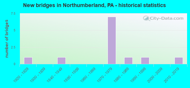
- New bridges - historical statistics
- 11920-1929
- 11940-1949
- 71970-1979
- 11980-1989
- 11990-1999
- 12010-2019


- Bridge Condition - Superstructure
- 40.0%Good
- 20.0%Satisfactory
- 40.0%Fair

- Bridge Condition - Substructure
- 40.0%Good
- 40.0%Satisfactory
- 20.0%Fair

- Bridge Condition - Channel
- 50.0%Satisfactory
- 33.3%Fair
- 16.7%Poor
Find on map >> Show street view
Structure Number: 28954, Location: NORTH'D BORO BLUE HILL BR (Lat: 40.882000, Lng: -76.800586), Route carried "on" structure: US 11, Year Built: 1925, Year Reconstructed: 1978, Status: Open, Structure Length: 41.79m (137.11ft), Average Daily Traffic: 16,116 (year 2020), Truck Traffic: 15%, Average Future Daily Traffic: 20,358 (year 2032), Design Load: HS 20, Features Intersected: W. B. SUSQUEHANNA RIVER
Minimum Vertical Clearance: 30+ m (98+ ft), Kilometerpoint: 0.000, Lanes on structure: 2, Base Highway Network: Yes, Owner: State Highway Agency, Approaching Roadway Width: 13.4m (44.0ft), Navigation Control: Yes ( Vertical Clearance: 999.7m (3,279.9ft), Horizontal Clearance: 9999.9m (32,808.1ft)), Material/Design: Steel continuous, Design/Construction: Stringer/Multi-beam, Number Of Spans In Main Unit: 11, Length of Maximum Span: 40.2m (131.9ft), Curb or Sidewalk Widths: Left: 1.0m (3.3ft), Right: 0.2m (0.7ft), Curb-To-Curb Width: 13.9m (45.6ft), Out-to-Out Width: 15.9m (52.2ft)
Condition: Deck: Good, Superstructure: Good, Substructure: Fair, Channel: Poor, Operating Rating: 56.2 metric tons, Method Used To Determine Operating Rating: Load Factor (LF), Inventory Rating: 33.6 metric tons, Method Used To Determine Inventory Rating: Load Factor (LF), Structural Evaluation: Somewhat better than minimum adequacy, Deck Geometry: Superior to present desirable criteria, Waterway Adequacy: Meets minimum limits, Approach Roadway Alignment: Equal to present minimum criteria, Length Of Structure Improvement: 42.40m (139.11ft), Designated Inspection Frequency: Every 24 months, Underwater Inspection Frequency: Every 24 months, Inspection Date: October 2020, Underwater Inspection Date: July 2021, Bridge Improvement Cost: $233,000, Roadway Improvement Cost: $687,000, Total Project Cost: $3,148,000, Deck Structure Type: Concrete Cast-file-Place, Wearing Surface/Protective System: Wearing Surface: Epoxy Overlay, Deck Protection: Epoxy Coated Reinforcing
Find on map >> Show street view
Structure Number: 28956, Location: 1.5 MI NE OF NORTHD BORO (Lat: 40.908969, Lng: -76.767281), Route carried "on" structure: US 11, Year Built: 1942, Status: Open, Structure Length: 0.91m (2.99ft), Average Daily Traffic: 11,057 (year 2022), Truck Traffic: 8%, Average Future Daily Traffic: 18,844 (year 2032), Features Intersected: JOHNSONS RUN
Minimum Vertical Clearance: 30+ m (98+ ft), Kilometerpoint: 4.281, Lanes on structure: 3, Base Highway Network: Yes, Owner: State Highway Agency, Approaching Roadway Width: 15.8m (51.8ft), Material/Design: Masonry, Design/Construction: Culvert, Number Of Spans In Main Unit: 1, Length of Maximum Span: 9.1m (29.9ft)
Condition: Channel: Fair, Culverts: Satisfactory, Operating Rating: 54.4 metric tons, Method Used To Determine Operating Rating: Field evaluation and documented engineering judgment, Inventory Rating: 32.7 metric tons, Method Used To Determine Inventory Rating: Field evaluation and documented engineering judgment, Structural Evaluation: Equal to present minimum criteria, Waterway Adequacy: Superior to present desirable criteria, Approach Roadway Alignment: Equal to present desirable criteria, Length Of Structure Improvement: 0.90m (2.95ft), Designated Inspection Frequency: Every 23 months, Other Special Inspection Frequency: Every 11 months, Inspection Date: April 2021, Other Special Inspection Date: April 2021
Find on map >> Show street view
Structure Number: 29048, Location: NORTH'D/PACKERS ISLAND BR (Lat: 40.887431, Lng: -76.789769), Route carried "on" structure: State highway 147, Year Built: 1988, Status: Open, Structure Length: 27.25m (89.40ft), Average Daily Traffic: 11,961 (year 2020), Truck Traffic: 7%, Average Future Daily Traffic: 19,703 (year 2032), Design Load: HS 25 or greater, Features Intersected: N. B. SUSQUEHANNA RIVER
Minimum Vertical Clearance: 30+ m (98+ ft), Kilometerpoint: 40.053, Lanes on structure: 2, Base Highway Network: Yes, Owner: State Highway Agency, Approaching Roadway Width: 12.2m (40.0ft), Skew: 1 degrees, Navigation Control: Yes ( Vertical Clearance: 9.8m (32.2ft), Horizontal Clearance: 45.1m (148.0ft)), Material/Design: Prestressed concrete continuous, Design/Construction: Stringer/Multi-beam, Number Of Spans In Main Unit: 6, Length of Maximum Span: 45.1m (148.0ft), Curb or Sidewalk Widths: Left: 0.2m (0.7ft), Right: 1.5m (4.9ft), Curb-To-Curb Width: 12.2m (40.0ft), Out-to-Out Width: 14.9m (48.9ft)
Condition: Deck: Good, Superstructure: Satisfactory, Substructure: Satisfactory, Channel: Fair, Operating Rating: 76.2 metric tons, Method Used To Determine Operating Rating: Load Factor (LF), Inventory Rating: 34.5 metric tons, Method Used To Determine Inventory Rating: Load Factor (LF), Structural Evaluation: Equal to present minimum criteria, Deck Geometry: Somewhat better than minimum adequacy, Waterway Adequacy: Superior to present desirable criteria, Approach Roadway Alignment: Equal to present desirable criteria, Length Of Structure Improvement: 27.70m (90.88ft), Designated Inspection Frequency: Every 24 months, Underwater Inspection Frequency: Every 24 months, Inspection Date: November 2021, Underwater Inspection Date: June 2020, Deck Structure Type: Concrete Cast-file-Place, Wearing Surface/Protective System: Wearing Surface: Monolithic Concrete, Deck Protection: Epoxy Coated Reinforcing
Find on map >> Show street view
Structure Number: 29345, Location: 2.5 MI NE OF NORTH'D BORO (Lat: 40.912542, Lng: -76.766600), Route carried "on" structure: City street , Year Built: 1991, Status: Open, Structure Length: 1.46m (4.79ft), Average Daily Traffic: 150 (year 2021), Truck Traffic: 2%, Average Future Daily Traffic: 232 (year 2043), Design Load: HS 25 or greater, Features Intersected: LITHIA SPRINGS CREEK, Facility Carried by Structure: POINT TWP RD T-702
Minimum Vertical Clearance: 30+ m (98+ ft), Kilometerpoint: 0.000, Lanes on structure: 2, Owner: Town or Township Highway Agency, Approaching Roadway Width: 8.5m (27.9ft), Skew: 3 degrees, Material/Design: Prestressed concrete, Design/Construction: Box Beam or Girders - Single/Spread, Number Of Spans In Main Unit: 1, Length of Maximum Span: 14.0m (45.9ft), Curb or Sidewalk Widths: Left: 0.2m (0.7ft), Right: 0.2m (0.7ft), Curb-To-Curb Width: 8.6m (28.2ft), Out-to-Out Width: 9.7m (31.8ft)
Condition: Deck: Good, Superstructure: Good, Substructure: Good, Channel: Satisfactory, Operating Rating: 76.2 metric tons, Method Used To Determine Operating Rating: Load Factor (LF), Inventory Rating: 44.5 metric tons, Method Used To Determine Inventory Rating: Load Factor (LF), Structural Evaluation: Better than present minimum criteria, Deck Geometry: Equal to present minimum criteria, Waterway Adequacy: Better than present minimum criteria, Approach Roadway Alignment: Equal to present desirable criteria, Length Of Structure Improvement: 1.50m (4.92ft), Designated Inspection Frequency: Every 24 months, Inspection Date: April 2021, Deck Structure Type: Concrete Cast-file-Place, Wearing Surface/Protective System: Wearing Surface: Epoxy Overlay, Deck Protection: Epoxy Coated Reinforcing
Find on map >> Show street view
Structure Number: 31044, Location: 1.7 MI S OF SELINSGROVE (Lat: 40.878972, Lng: -76.799614), Route carried "on" structure: US 11, Year Built: 1975, Status: Open, Structure Length: 13.41m (44.00ft), Average Daily Traffic: 7,571 (year 2021), Truck Traffic: 24%, Average Future Daily Traffic: 10,366 (year 2032), Design Load: HS 20, Features Intersected: OVER PENNS CREEK
Minimum Vertical Clearance: 30+ m (98+ ft), Kilometerpoint: 17.302, Lanes on structure: 2, Base Highway Network: Yes, Owner: State Highway Agency, Approaching Roadway Width: 11.3m (37.1ft), Skew: 12 degrees, Material/Design: Prestressed concrete, Design/Construction: Stringer/Multi-beam, Number Of Spans In Main Unit: 5, Length of Maximum Span: 26.8m (87.9ft), Curb or Sidewalk Widths: Left: 0.2m (0.7ft), Right: 0.2m (0.7ft), Curb-To-Curb Width: 11.9m (39.0ft), Out-to-Out Width: 13.2m (43.3ft)
Condition: Deck: Good, Superstructure: Fair, Substructure: Satisfactory, Channel: Satisfactory, Operating Rating: 51.7 metric tons, Method Used To Determine Operating Rating: Load Factor (LF), Inventory Rating: 30.8 metric tons, Method Used To Determine Inventory Rating: Load Factor (LF), Structural Evaluation: Somewhat better than minimum adequacy, Deck Geometry: Better than present minimum criteria, Waterway Adequacy: Superior to present desirable criteria, Approach Roadway Alignment: Equal to present desirable criteria, Length Of Structure Improvement: 14.40m (47.24ft), Designated Inspection Frequency: Every 24 months, Underwater Inspection Frequency: Every 60 months, Inspection Date: July 2020, Underwater Inspection Date: July 2018, Deck Structure Type: Concrete Cast-file-Place, Wearing Surface/Protective System: Wearing Surface: Monolithic Concrete, Deck Protection: Galvanized Reinforcing
Find on map >> Show street view
Structure Number: 31053, Location: 1 MI N OF SELINSGROVE (Lat: 40.878972, Lng: -76.799614), Route carried "on" structure: US 11, Year Built: 1976, Status: Open, Structure Length: 5.36m (17.59ft), Average Daily Traffic: 9,295 (year 2021), Truck Traffic: 25%, Average Future Daily Traffic: 8,464 (year 2032), Design Load: HS 20, Features Intersected: NEW SR 11/15 OVER SR 522
Minimum Vertical Clearance: 30+ m (98+ ft), Kilometerpoint: 21.876, Lanes on structure: 2, Lanes under structure: 6, Base Highway Network: Yes, Owner: State Highway Agency, Approaching Roadway Width: 16.2m (53.1ft), Skew: 11 degrees, Material/Design: Prestressed concrete, Design/Construction: Stringer/Multi-beam, Number Of Spans In Main Unit: 3, Length of Maximum Span: 33.8m (110.9ft), Curb or Sidewalk Widths: Left: 0.2m (0.7ft), Right: 0.2m (0.7ft), Curb-To-Curb Width: 16.2m (53.1ft), Out-to-Out Width: 17.3m (56.8ft)
Condition: Deck: Good, Superstructure: Fair, Substructure: Good, Operating Rating: 67.1 metric tons, Method Used To Determine Operating Rating: Load Factor (LF), Inventory Rating: 39.0 metric tons, Method Used To Determine Inventory Rating: Load Factor (LF), Structural Evaluation: Somewhat better than minimum adequacy, Deck Geometry: Superior to present desirable criteria, Underclear: Equal to present minimum criteria, Approach Roadway Alignment: Equal to present desirable criteria, Length Of Structure Improvement: 6.30m (20.67ft), Designated Inspection Frequency: Every 24 months, Inspection Date: April 2021, Deck Structure Type: Concrete Cast-file-Place, Wearing Surface/Protective System: Wearing Surface: Epoxy Overlay, Deck Protection: Epoxy Coated Reinforcing
Find on map >> Show street view
Structure Number: 47491, Location: 2.3 MI. N. NORTHUMBERLAND (Lat: 40.921047, Lng: -76.777897), Route carried "on" structure: City street , Year Built: 2012, Status: Open, Structure Length: 0.73m (2.40ft), Average Daily Traffic: 100 (year 2021), Truck Traffic: 1%, Average Future Daily Traffic: 154 (year 2043), Design Load: HS 20, Features Intersected: JOHNSON CREEK, Facility Carried by Structure: T-568 NEITZ ROAD
Minimum Vertical Clearance: 30+ m (98+ ft), Kilometerpoint: 0.000, Lanes on structure: 2, Owner: Town or Township Highway Agency, Approaching Roadway Width: 6.1m (20.0ft), Skew: 1 degrees, Material/Design: Aluminum, Iron, Design/Construction: Culvert, Number Of Spans In Main Unit: 1, Length of Maximum Span: 6.4m (21.0ft)
Condition: Channel: Satisfactory, Culverts: Satisfactory, Operating Rating: 54.4 metric tons, Method Used To Determine Operating Rating: Field evaluation and documented engineering judgment, Inventory Rating: 32.7 metric tons, Method Used To Determine Inventory Rating: Field evaluation and documented engineering judgment, Structural Evaluation: Equal to present minimum criteria, Waterway Adequacy: Better than present minimum criteria, Approach Roadway Alignment: Equal to present desirable criteria, Designated Inspection Frequency: Every 24 months, Inspection Date: April 2021
Find on map >> Show street view
Structure Number: 31049, Location: BORO OF SELINSGROVE (Lat: 40.878972, Lng: -76.799614), Route carried "under" structure: City street E, Year Built: 1976, Structure Length: 0. m, Average Daily Traffic: 100 (year 2009), Truck Traffic: 10%, Features Intersected: OVER PINE ST., Facility Carried by Structure: US TR 11 & 15 SBL
Minimum Vertical Clearance: 4.78m (15.68ft), Kilometerpoint: 0.000, Lanes on structure: 2, Lanes under structure: 2, Material/Design: Prestressed concrete, Design/Construction: Stringer/Multi-beam, Length of Maximum Span: 31.7m (104.0ft)
Find on map >> Show street view
Structure Number: 31053, Location: 1 MI N OF SELINSGROVE (Lat: 40.878972, Lng: -76.799614), Route carried "under" structure: US 11, Year Built: 1976, Structure Length: 0. m, Average Daily Traffic: 19,570 (year 2022), Truck Traffic: 9%, Features Intersected: NEW SR 11/15 OVER SR 522
Minimum Vertical Clearance: 4.56m (14.96ft), Kilometerpoint: 22.912, Lanes on structure: 2, Lanes under structure: 1, Material/Design: Prestressed concrete, Design/Construction: Stringer/Multi-beam, Length of Maximum Span: 33.8m (110.9ft)
Find on map >> Show street view
Structure Number: 31053, Location: 1 MI N OF SELINSGROVE (Lat: 40.878972, Lng: -76.799614), Route carried "under" structure: US 11, Year Built: 1976, Structure Length: 0. m, Average Daily Traffic: 19,839 (year 2022), Truck Traffic: 9%, Features Intersected: NEW SR 11/15 OVER SR 522
Minimum Vertical Clearance: 4.56m (14.96ft), Kilometerpoint: 22.755, Lanes on structure: 2, Lanes under structure: 1, Material/Design: Prestressed concrete, Design/Construction: Stringer/Multi-beam, Length of Maximum Span: 33.8m (110.9ft)
Find on map >> Show street view
Structure Number: 31053, Location: 1 MI N OF SELINSGROVE (Lat: 40.878972, Lng: -76.799614), Route carried "under" structure: US 522, Year Built: 1976, Structure Length: 0. m, Average Daily Traffic: 8,805 (year 2022), Truck Traffic: 6%, Features Intersected: NEW SR 11/15 OVER SR 522, Facility Carried by Structure: 11/15w/STR.MTD.SGN
Minimum Vertical Clearance: 30+ m (98+ ft), Kilometerpoint: 44.812, Lanes on structure: 2, Lanes under structure: 2, Material/Design: Prestressed concrete, Design/Construction: Stringer/Multi-beam, Length of Maximum Span: 33.8m (110.9ft)