Bridge Statistics for Ore City, Texas (TX)
Condition, Traffic, Stress, Structural Evaluation, Project Costs
- National Bridge Inventory (NBI) Statistics
- 13Number of bridges
- 217ft / 66.2mTotal length
- $2,316,000Total costs
- 63,018Total average daily traffic
- 8,400Total average daily truck traffic
- National Bridge Inventory (NBI) Registered Bridges for Ore City
- No street view available for this location
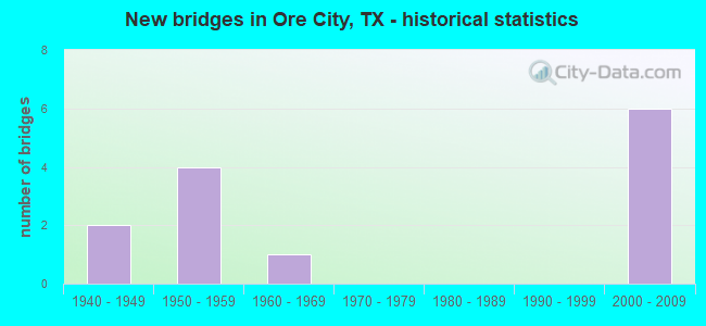
- New bridges - historical statistics
- 21940-1949
- 41950-1959
- 11960-1969
- 62000-2009

- Reconstructed bridges - Historical Statistics
- 11950-1959
- 01960-1969
- 01970-1979
- 01980-1989
- 01990-1999
- 42000-2009


- Bridge Condition - Deck
- 50.0%Good
- 50.0%Satisfactory

- Bridge Condition - Superstructure
- 66.7%Good
- 33.3%Satisfactory

- Bridge Condition - Substructure
- 33.3%Good
- 50.0%Satisfactory
- 16.7%Poor

- Bridge Condition - Channel
- 40.0%Good
- 50.0%Satisfactory
- 10.0%Fair

- Bridge Condition - Culverts
- 33.3%Good
- 66.7%Satisfactory
Find on map >> Show street view
Structure Number: 191550052004045, Location: 1.60 MI E OF US 259 (Lat: 32.851108, Lng: -94.698378), Route carried "on" structure: State highway 155, Year Built: 1954, Status: Open, Structure Length: 35.54m (116.60ft), Average Daily Traffic: 4,762 (year 2020), Truck Traffic: 12%, Average Future Daily Traffic: 6,060 (year 2033), Features Intersected: LAKE OF THE PINES
Minimum Vertical Clearance: 30+ m (98+ ft), Kilometerpoint: 8.533, Lanes on structure: 2, Owner: State Highway Agency, Approaching Roadway Width: 12.2m (40.0ft), Material/Design: Steel continuous, Design/Construction: Stringer/Multi-beam, Number Of Spans In Main Unit: 3, Number Of Approach Spans: 33, Length of Maximum Span: 19.8m (65.0ft), Curb-To-Curb Width: 8.4m (27.6ft), Out-to-Out Width: 9.5m (31.2ft)
Condition: Deck: Satisfactory, Superstructure: Satisfactory, Substructure: Poor, Channel: Fair, Operating Rating: 39.9 metric tons, Method Used To Determine Operating Rating: Load Factor (LF), Inventory Rating: 24.5 metric tons, Method Used To Determine Inventory Rating: Load Factor (LF), Structural Evaluation: Meets minimum limits, Deck Geometry: High priority of corrective action, Waterway Adequacy: Superior to present desirable criteria, Approach Roadway Alignment: Equal to present desirable criteria, Length Of Structure Improvement: 36.67m (120.31ft), Designated Inspection Frequency: Every 24 months, Underwater Inspection Frequency: Every 60 months, Inspection Date: September 2020, Underwater Inspection Date: April 2020, Bridge Improvement Cost: $1,853,000, Roadway Improvement Cost: $463,000, Total Project Cost: $2,316,000, Deck Structure Type: Concrete Cast-file-Place, Wearing Surface/Protective System: Wearing Surface: Bituminous
Find on map >> Show street view
Structure Number: 191550138202001, Location: 3.10 MI NW OF FM 726 (Lat: 32.785272, Lng: -94.678508), Route carried "on" structure: State highway 450, Year Built: 1951, Year Reconstructed: 2006, Status: Open, Structure Length: 0.82m (2.69ft), Average Daily Traffic: 661 (year 2020), Truck Traffic: 14%, Average Future Daily Traffic: 990 (year 2033), Features Intersected: SANDY CREEK
Minimum Vertical Clearance: 30+ m (98+ ft), Kilometerpoint: 2.654, Lanes on structure: 2, Owner: State Highway Agency, Approaching Roadway Width: 7.9m (25.9ft), Material/Design: Concrete, Design/Construction: Culvert, Number Of Spans In Main Unit: 4, Length of Maximum Span: 1.8m (5.9ft)
Condition: Channel: Good, Culverts: Satisfactory, Operating Rating: 32.7 metric tons, Method Used To Determine Operating Rating: Field evaluation and documented engineering judgment, Inventory Rating: 24.5 metric tons, Method Used To Determine Inventory Rating: Field evaluation and documented engineering judgment, Structural Evaluation: Equal to present minimum criteria, Waterway Adequacy: Equal to present minimum criteria, Approach Roadway Alignment: Equal to present desirable criteria, Designated Inspection Frequency: Every 24 months, Inspection Date: September 2020
Find on map >> Show street view
Structure Number: 192300039202017, Location: 0.50 MI S OF SH 155 (Lat: 32.836972, Lng: -94.726367), Route carried "on" structure: US 259, Year Built: 1942, Year Reconstructed: 2009, Status: Open, Structure Length: 1.19m (3.90ft), Average Daily Traffic: 8,219 (year 2020), Truck Traffic: 12%, Average Future Daily Traffic: 12,020 (year 2033), Design Load: H 15, Features Intersected: DRAW
Minimum Vertical Clearance: 30+ m (98+ ft), Kilometerpoint: 8.512, Lanes on structure: 3, Owner: State Highway Agency, Approaching Roadway Width: 21.9m (71.9ft), Skew: 20 degrees, Material/Design: Concrete, Design/Construction: Culvert, Number Of Spans In Main Unit: 6, Length of Maximum Span: 1.8m (5.9ft)
Condition: Channel: Good, Culverts: Good, Operating Rating: 32.7 metric tons, Method Used To Determine Operating Rating: Field evaluation and documented engineering judgment, Inventory Rating: 24.5 metric tons, Method Used To Determine Inventory Rating: Field evaluation and documented engineering judgment, Structural Evaluation: Equal to present minimum criteria, Waterway Adequacy: Equal to present minimum criteria, Approach Roadway Alignment: Equal to present desirable criteria, Designated Inspection Frequency: Every 24 months, Inspection Date: July 2021
Find on map >> Show street view
Structure Number: 192300039202018, Location: 2.20 MI S OF SH 155 (Lat: 32.813022, Lng: -94.718897), Route carried "on" structure: US 259, Year Built: 1942, Year Reconstructed: 1957, Status: Open, Structure Length: 5.33m (17.49ft), Average Daily Traffic: 4,184 (year 2020), Truck Traffic: 12%, Average Future Daily Traffic: 6,010 (year 2033), Design Load: H 15, Features Intersected: MEDDLIN CREEK
Minimum Vertical Clearance: 30+ m (98+ ft), Kilometerpoint: 11.261, Lanes on structure: 2, Owner: State Highway Agency, Approaching Roadway Width: 10.4m (34.1ft), Material/Design: Concrete, Design/Construction: Slab, Number Of Spans In Main Unit: 7, Length of Maximum Span: 7.6m (24.9ft), Curb-To-Curb Width: 10.6m (34.8ft), Out-to-Out Width: 12.0m (39.4ft)
Condition: Deck: Good, Superstructure: Good, Substructure: Satisfactory, Channel: Good, Operating Rating: 45.4 metric tons, Method Used To Determine Operating Rating: Load Factor (LF), Inventory Rating: 27.2 metric tons, Method Used To Determine Inventory Rating: Load Factor (LF), Structural Evaluation: Equal to present minimum criteria, Deck Geometry: Somewhat better than minimum adequacy, Waterway Adequacy: Equal to present minimum criteria, Approach Roadway Alignment: Equal to present desirable criteria, Designated Inspection Frequency: Every 24 months, Inspection Date: July 2021, Deck Structure Type: Concrete Cast-file-Place, Wearing Surface/Protective System: Wearing Surface: Bituminous
Find on map >> Show street view
Structure Number: 192300039202033, Location: 2.20 MI S OF SH 155 (Lat: 32.812528, Lng: -94.718403), Route carried "on" structure: US 259, Year Built: 1957, Status: Open, Structure Length: 5.55m (18.21ft), Average Daily Traffic: 4,035 (year 2020), Truck Traffic: 12%, Average Future Daily Traffic: 6,010 (year 2033), Design Load: HS 20, Features Intersected: MEDDLIN CREEK
Minimum Vertical Clearance: 30+ m (98+ ft), Kilometerpoint: 11.278, Lanes on structure: 2, Owner: State Highway Agency, Approaching Roadway Width: 10.6m (34.8ft), Material/Design: Concrete, Design/Construction: Stringer/Multi-beam, Number Of Spans In Main Unit: 6, Length of Maximum Span: 9.1m (29.9ft), Curb-To-Curb Width: 10.6m (34.8ft), Out-to-Out Width: 11.4m (37.4ft)
Condition: Deck: Good, Superstructure: Good, Substructure: Satisfactory, Channel: Satisfactory, Operating Rating: 68.0 metric tons, Method Used To Determine Operating Rating: Load Factor (LF), Inventory Rating: 40.8 metric tons, Method Used To Determine Inventory Rating: Load Factor (LF), Structural Evaluation: Equal to present minimum criteria, Deck Geometry: Somewhat better than minimum adequacy, Waterway Adequacy: Equal to present minimum criteria, Approach Roadway Alignment: Equal to present desirable criteria, Designated Inspection Frequency: Every 24 months, Inspection Date: July 2021, Deck Structure Type: Concrete Cast-file-Place, Wearing Surface/Protective System: Wearing Surface: Bituminous
Find on map >> Show street view
Structure Number: 192300039202051, Location: 2.10 MI N OF SH 154 (Lat: 32.740050, Lng: -94.747942), Route carried "on" structure: US 259, Year Built: 2001, Status: Open, Structure Length: 1.28m (4.20ft), Average Daily Traffic: 8,938 (year 2020), Truck Traffic: 16%, Average Future Daily Traffic: 12,040 (year 2031), Features Intersected: LITTLE WALNUT CREEK
Minimum Vertical Clearance: 30+ m (98+ ft), Kilometerpoint: 19.904, Lanes on structure: 5, Owner: State Highway Agency, Approaching Roadway Width: 26.2m (86.0ft), Material/Design: Concrete, Design/Construction: Culvert, Number Of Spans In Main Unit: 4, Length of Maximum Span: 3.0m (9.8ft)
Condition: Channel: Satisfactory, Culverts: Good, Operating Rating: 44.4 metric tons, Method Used To Determine Operating Rating: Field evaluation and documented engineering judgment, Inventory Rating: 32.7 metric tons, Method Used To Determine Inventory Rating: Field evaluation and documented engineering judgment, Structural Evaluation: Better than present minimum criteria, Waterway Adequacy: Superior to present desirable criteria, Approach Roadway Alignment: Equal to present desirable criteria, Designated Inspection Frequency: Every 48 months, Inspection Date: July 2019
Find on map >> Show street view
Structure Number: 192300039202052, Location: 1.10 MI N OF FM 726 (Lat: 32.749294, Lng: -94.744736), Route carried "on" structure: US 259, Year Built: 2000, Status: Open, Structure Length: 2.47m (8.10ft), Average Daily Traffic: 8,938 (year 2020), Truck Traffic: 12%, Average Future Daily Traffic: 12,240 (year 2033), Design Load: HS 20, Features Intersected: BEACHMAN CREEK
Minimum Vertical Clearance: 30+ m (98+ ft), Kilometerpoint: 18.726, Lanes on structure: 4, Owner: State Highway Agency, Approaching Roadway Width: 23.2m (76.1ft), Skew: 4 degrees, Material/Design: Concrete, Design/Construction: Culvert, Number Of Spans In Main Unit: 6, Length of Maximum Span: 2.7m (8.9ft)
Condition: Channel: Satisfactory, Culverts: Satisfactory, Operating Rating: 44.4 metric tons, Method Used To Determine Operating Rating: No rating analysis performed, Inventory Rating: 32.7 metric tons, Method Used To Determine Inventory Rating: No rating analysis performed, Structural Evaluation: Equal to present minimum criteria, Waterway Adequacy: Superior to present desirable criteria, Approach Roadway Alignment: Equal to present desirable criteria, Designated Inspection Frequency: Every 48 months, Inspection Date: July 2021
Find on map >> Show street view
Structure Number: 192300039202053, Location: 0.05 MI N OF SH 155 (Lat: 32.844608, Lng: -94.729261), Route carried "on" structure: US 259, Year Built: 2009, Status: Open, Structure Length: 1.43m (4.69ft), Average Daily Traffic: 5,682 (year 2020), Truck Traffic: 15%, Average Future Daily Traffic: 9,120 (year 2031), Design Load: HS 20, Features Intersected: CEDAR SPRINGS CREEK
Minimum Vertical Clearance: 30+ m (98+ ft), Kilometerpoint: 7.646, Lanes on structure: 6, Owner: State Highway Agency, Approaching Roadway Width: 23.2m (76.1ft), Skew: 29 degrees, Material/Design: Concrete, Design/Construction: Culvert, Number Of Spans In Main Unit: 4, Length of Maximum Span: 3.0m (9.8ft)
Condition: Channel: Good, Culverts: Satisfactory, Operating Rating: 44.4 metric tons, Method Used To Determine Operating Rating: No rating analysis performed, Inventory Rating: 32.7 metric tons, Method Used To Determine Inventory Rating: No rating analysis performed, Structural Evaluation: Equal to present minimum criteria, Waterway Adequacy: Superior to present desirable criteria, Approach Roadway Alignment: Equal to present desirable criteria, Designated Inspection Frequency: Every 48 months, Inspection Date: July 2021
Find on map >> Show street view
Structure Number: 192300039202054, Location: INT SH 155 & US 259 (Lat: 32.843786, Lng: -94.728469), Route carried "on" structure: US 259, Year Built: 2009, Status: Open, Structure Length: 3.51m (11.52ft), Average Daily Traffic: 2,798 (year 2020), Truck Traffic: 15%, Average Future Daily Traffic: 4,560 (year 2031), Design Load: HL 93, Features Intersected: SH 155
Minimum Vertical Clearance: 30+ m (98+ ft), Kilometerpoint: 7.731, Lanes on structure: 2, Lanes under structure: 4, Owner: State Highway Agency, Approaching Roadway Width: 11.6m (38.1ft), Material/Design: Prestressed concrete, Design/Construction: Stringer/Multi-beam, Number Of Spans In Main Unit: 1, Length of Maximum Span: 35.1m (115.2ft), Curb-To-Curb Width: 11.3m (37.1ft), Out-to-Out Width: 12.2m (40.0ft)
Condition: Deck: Satisfactory, Superstructure: Good, Substructure: Good, Operating Rating: 54.4 metric tons, Method Used To Determine Operating Rating: Assigned ratings based on Load and Resistance Factor Design (LRFD) reported in metric tons, Inventory Rating: 32.7 metric tons, Method Used To Determine Inventory Rating: Assigned ratings based on Load and Resistance Factor Design (LRFD) reported in metric tons, Structural Evaluation: Better than present minimum criteria, Deck Geometry: Equal to present minimum criteria, Underclear: Somewhat better than minimum adequacy, Approach Roadway Alignment: Equal to present desirable criteria, Designated Inspection Frequency: Every 24 months, Inspection Date: July 2021, Deck Structure Type: Concrete Cast-file-Place
Find on map >> Show street view
Structure Number: 192300039202055, Location: INT SH 155 & US 259 (Lat: 32.843558, Lng: -94.727994), Route carried "on" structure: US 259, Year Built: 2009, Status: Open, Structure Length: 3.51m (11.52ft), Average Daily Traffic: 2,884 (year 2020), Truck Traffic: 15%, Average Future Daily Traffic: 4,560 (year 2031), Design Load: HL 93, Features Intersected: SH 155
Minimum Vertical Clearance: 30+ m (98+ ft), Kilometerpoint: 7.731, Lanes on structure: 2, Lanes under structure: 4, Owner: State Highway Agency, Approaching Roadway Width: 11.6m (38.1ft), Material/Design: Prestressed concrete, Design/Construction: Stringer/Multi-beam, Number Of Spans In Main Unit: 1, Length of Maximum Span: 35.1m (115.2ft), Curb-To-Curb Width: 11.3m (37.1ft), Out-to-Out Width: 12.2m (40.0ft)
Condition: Deck: Satisfactory, Superstructure: Good, Substructure: Good, Operating Rating: 54.4 metric tons, Method Used To Determine Operating Rating: Assigned ratings based on Load and Resistance Factor Design (LRFD) reported in metric tons, Inventory Rating: 32.7 metric tons, Method Used To Determine Inventory Rating: Assigned ratings based on Load and Resistance Factor Design (LRFD) reported in metric tons, Structural Evaluation: Better than present minimum criteria, Deck Geometry: Equal to present minimum criteria, Underclear: Somewhat better than minimum adequacy, Approach Roadway Alignment: Equal to present desirable criteria, Designated Inspection Frequency: Every 24 months, Inspection Date: July 2021, Deck Structure Type: Concrete Cast-file-Place
Find on map >> Show street view
Structure Number: 192300052005044, Location: 0.15 MI E OF US 259 (Lat: 32.843897, Lng: -94.726889), Route carried "on" structure: State highway 155, Year Built: 1954, Year Reconstructed: 2009, Status: Open, Structure Length: 1.83m (6.00ft), Average Daily Traffic: 5,360 (year 2020), Truck Traffic: 13%, Average Future Daily Traffic: 7,390 (year 2033), Design Load: H 20, Features Intersected: CEDAR SPRINGS CREEK
Minimum Vertical Clearance: 30+ m (98+ ft), Kilometerpoint: 2.454, Lanes on structure: 4, Owner: State Highway Agency, Approaching Roadway Width: 29.3m (96.1ft), Skew: 4 degrees, Material/Design: Concrete, Design/Construction: Culvert, Number Of Spans In Main Unit: 4, Length of Maximum Span: 3.0m (9.8ft)
Condition: Channel: Satisfactory, Culverts: Satisfactory, Operating Rating: 39.9 metric tons, Method Used To Determine Operating Rating: Load Factor (LF), Inventory Rating: 23.6 metric tons, Method Used To Determine Inventory Rating: Load Factor (LF), Structural Evaluation: Somewhat better than minimum adequacy, Waterway Adequacy: Superior to present desirable criteria, Approach Roadway Alignment: Equal to present desirable criteria, Designated Inspection Frequency: Every 24 months, Inspection Date: July 2021
Find on map >> Show street view
Structure Number: 192300189501004, Location: 0.15 MI E OF US 259 (Lat: 32.740094, Lng: -94.745456), Route carried "on" structure: State highway 726, Year Built: 1964, Year Reconstructed: 2009, Status: Open, Structure Length: 3.69m (12.11ft), Average Daily Traffic: 1,277 (year 2020), Truck Traffic: 14%, Average Future Daily Traffic: 1,700 (year 2033), Design Load: H 15, Features Intersected: WALNUT CREEK
Minimum Vertical Clearance: 30+ m (98+ ft), Kilometerpoint: 1.036, Lanes on structure: 2, Owner: State Highway Agency, Approaching Roadway Width: 13.4m (44.0ft), Material/Design: Concrete, Design/Construction: Stringer/Multi-beam, Number Of Spans In Main Unit: 4, Length of Maximum Span: 9.1m (29.9ft), Curb-To-Curb Width: 13.1m (43.0ft), Out-to-Out Width: 14.0m (45.9ft)
Condition: Deck: Good, Superstructure: Satisfactory, Substructure: Satisfactory, Channel: Satisfactory, Operating Rating: 56.2 metric tons, Method Used To Determine Operating Rating: Load Factor (LF), Inventory Rating: 33.6 metric tons, Method Used To Determine Inventory Rating: Load Factor (LF), Structural Evaluation: Equal to present minimum criteria, Deck Geometry: Better than present minimum criteria, Waterway Adequacy: Equal to present minimum criteria, Approach Roadway Alignment: Equal to present desirable criteria, Designated Inspection Frequency: Every 24 months, Inspection Date: July 2021, Deck Structure Type: Concrete Cast-file-Place, Wearing Surface/Protective System: Wearing Surface: Bituminous
Find on map >> Show street view
Structure Number: 192300039202055, Location: INT SH 155 & US 259 (Lat: 32.843692, Lng: -94.728142), Route carried "under" structure: State highway 155, Year Built: 2009, Structure Length: 0. m, Average Daily Traffic: 5,280 (year 2013), Truck Traffic: 13%, Features Intersected: US 259 NB, Facility Carried by Structure: US 259 NB
Minimum Vertical Clearance: 5.36m (17.59ft), Kilometerpoint: 2.565, Lanes on structure: 5, Material/Design: Prestressed concrete, Design/Construction: Stringer/Multi-beam, Length of Maximum Span: 35.1m (115.2ft)