Bridge Statistics for Palmer, Illinois (IL)
Condition, Traffic, Stress, Structural Evaluation, Project Costs
- National Bridge Inventory (NBI) Statistics
- 19Number of bridges
- 177ft / 53.5mTotal length
- $869,000Total costs
- 4,705Total average daily traffic
- 598Total average daily truck traffic
- 5,596Total future (year 2032) average daily traffic
- National Bridge Inventory (NBI) Registered Bridges for Palmer
- No street view available for this location
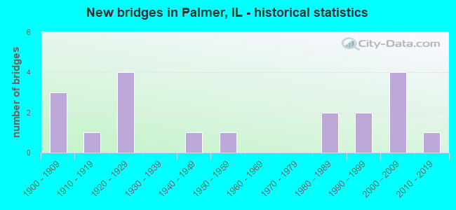
- New bridges - historical statistics
- 31900-1909
- 11910-1919
- 41920-1929
- 11940-1949
- 11950-1959
- 21980-1989
- 21990-1999
- 42000-2009
- 12010-2019


- Bridge Condition - Deck
- 11.8%Very good
- 41.2%Satisfactory
- 17.6%Fair
- 17.6%Poor
- 5.9%Serious
- 5.9%Failed

- Bridge Condition - Superstructure
- 11.8%Very good
- 5.9%Good
- 29.4%Satisfactory
- 11.8%Fair
- 17.6%Poor
- 11.8%Serious
- 5.9%Critical
- 5.9%Failed

- Bridge Condition - Substructure
- 35.3%Very good
- 11.8%Good
- 23.5%Satisfactory
- 11.8%Fair
- 5.9%Serious
- 5.9%Critical
- 5.9%Failed

- Bridge Condition - Channel
- 15.8%Very good
- 10.5%Good
- 36.8%Satisfactory
- 26.3%Fair
- 5.3%Poor
- 5.3%Failed

- Bridge Condition - Culverts
- 50.0%Fair
- 50.0%Serious
Find on map >> Show street view
Structure Number: 110514, Location: 1 mi SW Palmer (Lat: 39.443567, Lng: -89.425250), Route carried "on" structure: State highway 48, Year Built: 2014, Status: Open, Structure Length: 5.49m (18.01ft), Average Daily Traffic: 2,900 (year 2021), Truck Traffic: 12%, Average Future Daily Traffic: 2,956 (year 2032), Design Load: HS 25 or greater, Features Intersected: Bear Creek
Minimum Vertical Clearance: 30+ m (98+ ft), Kilometerpoint: 24.638, Lanes on structure: 2, Base Highway Network: Yes, Owner: State Highway Agency, Approaching Roadway Width: 11.0m (36.1ft), Skew: 3 degrees, Material/Design: Steel continuous, Design/Construction: Stringer/Multi-beam, Number Of Spans In Main Unit: 3, Length of Maximum Span: 21.9m (71.9ft), Curb-To-Curb Width: 11.0m (36.1ft), Out-to-Out Width: 11.9m (39.0ft)
Condition: Deck: Very good, Superstructure: Very good, Substructure: Very good, Channel: Very good, Operating Rating: 66.4 metric tons, Method Used To Determine Operating Rating: Load and Resistance Factor Rating (LRFR) rating reported by rating factor(RF) method using HL-93 loadings, Inventory Rating: 51.2 metric tons, Method Used To Determine Inventory Rating: Load and Resistance Factor Rating (LRFR) rating reported by rating factor(RF) method using HL-93 loadings, Structural Evaluation: Equal to present desirable criteria, Deck Geometry: Somewhat better than minimum adequacy, Waterway Adequacy: Superior to present desirable criteria, Approach Roadway Alignment: Equal to present desirable criteria, Designated Inspection Frequency: Every 48 months, Inspection Date: October 2020, Deck Structure Type: Concrete Cast-file-Place, Wearing Surface/Protective System: Deck Protection: Epoxy Coated Reinforcing
Find on map >> Show street view
Structure Number: 113055, Location: 4.75 M N MORRISONVIL (Lat: 39.498714, Lng: -89.460028), Route carried "on" structure: County highway , Year Built: 1900, Status: Posted for load, Structure Length: 0.79m (2.59ft), Average Daily Traffic: 50 (year 2021), Truck Traffic: 14%, Average Future Daily Traffic: 59 (year 2032), Features Intersected: CLEAR CREEK, Facility Carried by Structure: TR 28
Minimum Vertical Clearance: 30+ m (98+ ft), Kilometerpoint: 0.418, Lanes on structure: 1, Owner: Town or Township Highway Agency, Approaching Roadway Width: 4.3m (14.1ft), Material/Design: Steel, Design/Construction: Stringer/Multi-beam, Number Of Spans In Main Unit: 1, Length of Maximum Span: 7.3m (24.0ft), Curb-To-Curb Width: 4.1m (13.5ft), Out-to-Out Width: 6.2m (20.3ft)
Condition: Deck: Satisfactory, Superstructure: Fair, Substructure: Fair, Channel: Satisfactory, Operating Rating: 16.8 metric tons, Method Used To Determine Operating Rating: Allowable Stress (AS) rating reported by rating factor (RF) method using MS18 loading, Inventory Rating: 11.3 metric tons, Method Used To Determine Inventory Rating: Allowable Stress (AS) rating reported by rating factor (RF) method using MS18 loading, Structural Evaluation: Meets minimum limits, Deck Geometry: Somewhat better than minimum adequacy, Waterway Adequacy: Meets minimum limits, Approach Roadway Alignment: Equal to present minimum criteria, Bridge Posting: Required (Relationship of Operating Rating to Maximum Legal Load: > 39.9% below), Length Of Structure Improvement: 1.43m (4.69ft), Designated Inspection Frequency: Every 24 months, Inspection Date: November 2020, Bridge Improvement Cost: $46,000, Roadway Improvement Cost: $5,000, Total Project Cost: $69,000, Deck Structure Type: Wood or Timber, Wearing Surface/Protective System: Wearing Surface: Wood or Timber
Find on map >> Show street view
Structure Number: 113069, Location: 2 MI ENE MORRISONVLE (Lat: 39.429033, Lng: -89.419483), Route carried "on" structure: County highway , Year Built: 1921, Status: Open, Structure Length: 1.01m (3.31ft), Average Daily Traffic: 50 (year 2021), Truck Traffic: 16%, Average Future Daily Traffic: 50 (year 2032), Features Intersected: MILLER BRANCH, Facility Carried by Structure: TR 68
Minimum Vertical Clearance: 30+ m (98+ ft), Kilometerpoint: 2.543, Lanes on structure: 1, Owner: Town or Township Highway Agency, Approaching Roadway Width: 6.7m (22.0ft), Material/Design: Concrete, Number Of Spans In Main Unit: 1, Length of Maximum Span: 9.1m (29.9ft), Curb-To-Curb Width: 4.9m (16.1ft), Out-to-Out Width: 5.9m (19.4ft)
Condition: Deck: Fair, Superstructure: Poor, Substructure: Good, Channel: Fair, Operating Rating: 32.4 metric tons, Method Used To Determine Operating Rating: Field evaluation and documented engineering judgment, Inventory Rating: 19.4 metric tons, Method Used To Determine Inventory Rating: Field evaluation and documented engineering judgment, Structural Evaluation: Meets minimum limits, Deck Geometry: High priority of corrective action, Waterway Adequacy: Equal to present minimum criteria, Approach Roadway Alignment: Meets minimum limits, Length Of Structure Improvement: 1.01m (3.31ft), Designated Inspection Frequency: Every 24 months, Inspection Date: November 2019, Bridge Improvement Cost: $10,000, Roadway Improvement Cost: $1,000, Total Project Cost: $12,000, Deck Structure Type: Concrete Cast-file-Place, Wearing Surface/Protective System: Wearing Surface: Gravel
Find on map >> Show street view
Structure Number: 113071, Location: 1.75 MI N PALMER (Lat: 39.491472, Lng: -89.415558), Route carried "on" structure: County highway , Year Built: 1916, Status: Posted for load, Structure Length: 3.14m (10.30ft), Average Daily Traffic: 20 (year 2021), Truck Traffic: 20%, Average Future Daily Traffic: 100 (year 2032), Features Intersected: BEAR CREEK, Facility Carried by Structure: TR 70
Minimum Vertical Clearance: 4.85m (15.91ft), Kilometerpoint: 2.623, Lanes on structure: 1, Owner: Town or Township Highway Agency, Approaching Roadway Width: 4.0m (13.1ft), Material/Design: Steel, Design/Construction: Truss - Thru, Number Of Spans In Main Unit: 1, Length of Maximum Span: 30.5m (100.1ft), Curb-To-Curb Width: 4.8m (15.7ft), Out-to-Out Width: 5.6m (18.4ft)
Condition: Deck: Poor, Superstructure: Serious, Substructure: Satisfactory, Channel: Satisfactory, Operating Rating: 18.5 metric tons, Method Used To Determine Operating Rating: Allowable Stress (AS) rating reported by rating factor (RF) method using MS18 loading, Inventory Rating: 12.0 metric tons, Method Used To Determine Inventory Rating: Allowable Stress (AS) rating reported by rating factor (RF) method using MS18 loading, Structural Evaluation: High priority of corrective action, Deck Geometry: Equal to present desirable criteria, Waterway Adequacy: Meets minimum limits, Approach Roadway Alignment: Equal to present desirable criteria, Bridge Posting: Required (Relationship of Operating Rating to Maximum Legal Load: > 39.9% below), Length Of Structure Improvement: 4.11m (13.48ft), Designated Inspection Frequency: Every 24 months, Critical Feature Inspection Frequency: Every 12 months, Inspection Date: November 2020, Critical Feature Inspection Date: November 2020, Bridge Improvement Cost: $169,000, Roadway Improvement Cost: $17,000, Total Project Cost: $254,000, Deck Structure Type: Concrete Cast-file-Place, Wearing Surface/Protective System: Wearing Surface: Gravel
Find on map >> Show street view
Structure Number: 113082, Location: 3.5 E MORRISONVILLE (Lat: 39.415697, Lng: -89.383197), Route carried "on" structure: County highway , Year Built: 1921, Status: Posted for load, Structure Length: 0.79m (2.59ft), Average Daily Traffic: 100 (year 2021), Truck Traffic: 8%, Average Future Daily Traffic: 125 (year 2032), Features Intersected: MILLER BRANCH, Facility Carried by Structure: TR 92
Minimum Vertical Clearance: 30+ m (98+ ft), Kilometerpoint: 3.154, Lanes on structure: 1, Owner: Town or Township Highway Agency, Approaching Roadway Width: 7.3m (24.0ft), Skew: 3 degrees, Material/Design: Concrete, Design/Construction: Slab, Number Of Spans In Main Unit: 1, Length of Maximum Span: 7.0m (23.0ft), Curb-To-Curb Width: 4.9m (16.1ft), Out-to-Out Width: 5.5m (18.0ft)
Condition: Deck: Poor, Superstructure: Poor, Substructure: Satisfactory, Channel: Satisfactory, Operating Rating: 24.3 metric tons, Method Used To Determine Operating Rating: Load Factor (LF) rating reported by rating factor (RF) method using MS18 loading, Inventory Rating: 14.6 metric tons, Method Used To Determine Inventory Rating: Load Factor (LF) rating reported by rating factor (RF) method using MS18 loading, Structural Evaluation: Meets minimum limits, Deck Geometry: High priority of corrective action, Waterway Adequacy: Equal to present minimum criteria, Approach Roadway Alignment: Equal to present minimum criteria, Bridge Posting: Required (Relationship of Operating Rating to Maximum Legal Load: 10.0 - 19.9% below), Length Of Structure Improvement: 1.43m (4.69ft), Designated Inspection Frequency: Every 24 months, Inspection Date: November 2019, Bridge Improvement Cost: $41,000, Roadway Improvement Cost: $4,000, Total Project Cost: $62,000, Deck Structure Type: Concrete Cast-file-Place, Wearing Surface/Protective System: Wearing Surface: Gravel
Find on map >> Show street view
Structure Number: 113094, Location: 1.5 MI SE CLARKSDALE (Lat: 39.474950, Lng: -89.353411), Route carried "on" structure: County highway , Year Built: 1900, Status: Closed, Structure Length: 1.75m (5.74ft), Average Daily Traffic: 20 (year 2021), Truck Traffic: 15%, Average Future Daily Traffic: 29 (year 2032), Features Intersected: BRUSH CREEK, Facility Carried by Structure: TR 116
Minimum Vertical Clearance: 30+ m (98+ ft), Kilometerpoint: 1.062, Lanes on structure: 1, Owner: Town or Township Highway Agency, Approaching Roadway Width: 4.9m (16.1ft), Material/Design: Steel, Design/Construction: Stringer/Multi-beam, Number Of Spans In Main Unit: 2, Length of Maximum Span: 8.7m (28.5ft), Curb-To-Curb Width: 4.4m (14.4ft), Out-to-Out Width: 4.4m (14.4ft)
Condition: Deck: Failed, Superstructure: Failed, Substructure: Failed, Channel: Failed, Deck Geometry: Equal to present minimum criteria, Bridge Posting: Required (Relationship of Operating Rating to Maximum Legal Load: > 39.9% below), Length Of Structure Improvement: 2.44m (8.01ft), Designated Inspection Frequency: Every 24 months, Inspection Date: November 2019, Bridge Improvement Cost: $67,000, Roadway Improvement Cost: $7,000, Total Project Cost: $101,000, Deck Structure Type: Wood or Timber, Wearing Surface/Protective System: Wearing Surface: Wood or Timber
Find on map >> Show street view
Structure Number: 113175, Location: 5 MI N MORRISONVILLE (Lat: 39.502456, Lng: -89.457417), Route carried "on" structure: County highway , Year Built: 1900, Status: Closed, Structure Length: 0.73m (2.40ft), Average Daily Traffic: 20 (year 2021), Average Future Daily Traffic: 29 (year 2032), Features Intersected: CLEAR CREEK, Facility Carried by Structure: TR 221
Minimum Vertical Clearance: 30+ m (98+ ft), Kilometerpoint: 1.674, Lanes on structure: 1, Owner: Town or Township Highway Agency, Approaching Roadway Width: 4.6m (15.1ft), Material/Design: Steel, Design/Construction: Stringer/Multi-beam, Number Of Spans In Main Unit: 1, Length of Maximum Span: 7.0m (23.0ft), Curb-To-Curb Width: 4.6m (15.1ft), Out-to-Out Width: 5.1m (16.7ft)
Condition: Deck: Fair, Superstructure: Critical, Substructure: Fair, Channel: Fair, Deck Geometry: Better than present minimum criteria, Waterway Adequacy: Meets minimum limits, Approach Roadway Alignment: Equal to present minimum criteria, Bridge Posting: Required (Relationship of Operating Rating to Maximum Legal Load: > 39.9% below), Designated Inspection Frequency: Every 24 months, Inspection Date: November 2020, Deck Structure Type: Wood or Timber
Find on map >> Show street view
Structure Number: 113211, Location: 0.75 MI W. PALMER (Lat: 39.451278, Lng: -89.430469), Route carried "on" structure: County highway , Year Built: 1922, Status: Open, Structure Length: 4.39m (14.40ft), Average Daily Traffic: 50 (year 2021), Truck Traffic: 10%, Average Future Daily Traffic: 59 (year 2032), Features Intersected: BEAR CREEK, Facility Carried by Structure: TR 269
Minimum Vertical Clearance: 30+ m (98+ ft), Kilometerpoint: 0.048, Lanes on structure: 1, Owner: Town or Township Highway Agency, Approaching Roadway Width: 6.1m (20.0ft), Material/Design: Concrete, Number Of Spans In Main Unit: 6, Length of Maximum Span: 7.3m (24.0ft), Curb-To-Curb Width: 5.0m (16.4ft), Out-to-Out Width: 5.5m (18.0ft)
Condition: Deck: Serious, Superstructure: Serious, Substructure: Serious, Channel: Fair, Operating Rating: 40.5 metric tons, Method Used To Determine Operating Rating: Load Factor (LF) rating reported by rating factor (RF) method using MS18 loading, Inventory Rating: 24.3 metric tons, Method Used To Determine Inventory Rating: Load Factor (LF) rating reported by rating factor (RF) method using MS18 loading, Structural Evaluation: High priority of corrective action, Deck Geometry: High priority of corrective action, Waterway Adequacy: Equal to present minimum criteria, Approach Roadway Alignment: Equal to present minimum criteria, Length Of Structure Improvement: 5.27m (17.29ft), Designated Inspection Frequency: Every 24 months, Inspection Date: November 2020, Bridge Improvement Cost: $231,000, Roadway Improvement Cost: $23,000, Total Project Cost: $347,000, Deck Structure Type: Concrete Cast-file-Place, Wearing Surface/Protective System: Wearing Surface: Gravel
Find on map >> Show street view
Structure Number: 113276, Location: 3.5 N PALMER (Lat: 39.515775, Lng: -89.403817), Route carried "on" structure: County highway , Year Built: 1920, Status: Posted for load, Structure Length: 0.67m (2.20ft), Average Daily Traffic: 50 (year 2021), Truck Traffic: 28%, Average Future Daily Traffic: 109 (year 2032), Features Intersected: ACHENBACH BRANCH, Facility Carried by Structure: TR 82
Minimum Vertical Clearance: 30+ m (98+ ft), Kilometerpoint: 1.738, Lanes on structure: 1, Owner: Town or Township Highway Agency, Approaching Roadway Width: 4.3m (14.1ft), Material/Design: Concrete continuous, Design/Construction: Slab, Number Of Spans In Main Unit: 2, Length of Maximum Span: 3.2m (10.5ft), Curb-To-Curb Width: 4.6m (15.1ft), Out-to-Out Width: 4.6m (15.1ft)
Condition: Deck: Poor, Superstructure: Poor, Substructure: Critical, Channel: Poor, Operating Rating: 20.3 metric tons, Method Used To Determine Operating Rating: Field evaluation and documented engineering judgment, Inventory Rating: 12.2 metric tons, Method Used To Determine Inventory Rating: Field evaluation and documented engineering judgment, Structural Evaluation: High priority of replacement, Deck Geometry: Better than present minimum criteria, Waterway Adequacy: Meets minimum limits, Approach Roadway Alignment: Equal to present minimum criteria, Bridge Posting: Required (Relationship of Operating Rating to Maximum Legal Load: > 39.9% below), Length Of Structure Improvement: 0.67m (2.20ft), Designated Inspection Frequency: Every 24 months, Other Special Inspection Frequency: Every 12 months, Inspection Date: November 2020, Other Special Inspection Date: April 2021, Bridge Improvement Cost: $16,000, Roadway Improvement Cost: $2,000, Total Project Cost: $24,000, Deck Structure Type: Concrete Cast-file-Place, Wearing Surface/Protective System: Wearing Surface: Gravel
Find on map >> Show street view
Structure Number: 113299, Location: 2.75 M N OF PALMER (Lat: 39.506625, Lng: -89.403714), Route carried "on" structure: County highway , Year Built: 1980, Status: Open, Structure Length: 5.47m (17.95ft), Average Daily Traffic: 250 (year 2021), Truck Traffic: 8%, Average Future Daily Traffic: 301 (year 2032), Design Load: HS 20, Features Intersected: BEAR CREEK, Facility Carried by Structure: FAS 639
Minimum Vertical Clearance: 30+ m (98+ ft), Kilometerpoint: 18.958, Lanes on structure: 2, Owner: County Highway Agency, Approaching Roadway Width: 6.7m (22.0ft), Material/Design: Steel continuous, Design/Construction: Stringer/Multi-beam, Number Of Spans In Main Unit: 3, Length of Maximum Span: 19.8m (65.0ft), Curb-To-Curb Width: 7.3m (24.0ft), Out-to-Out Width: 8.3m (27.2ft)
Condition: Deck: Satisfactory, Superstructure: Good, Substructure: Satisfactory, Channel: Satisfactory, Operating Rating: 73.2 metric tons, Method Used To Determine Operating Rating: Load Factor (LF) rating reported by rating factor (RF) method using MS18 loading, Inventory Rating: 43.7 metric tons, Method Used To Determine Inventory Rating: Load Factor (LF) rating reported by rating factor (RF) method using MS18 loading, Structural Evaluation: Equal to present minimum criteria, Deck Geometry: Somewhat better than minimum adequacy, Waterway Adequacy: Equal to present desirable criteria, Approach Roadway Alignment: Equal to present desirable criteria, Designated Inspection Frequency: Every 24 months, Inspection Date: December 2020, Deck Structure Type: Concrete Cast-file-Place
Find on map >> Show street view
Structure Number: 113301, Location: 3 N OF PALMER (Lat: 39.509928, Lng: -89.397300), Route carried "on" structure: County highway , Year Built: 1987, Status: Open, Structure Length: 6.56m (21.52ft), Average Daily Traffic: 75 (year 2021), Truck Traffic: 8%, Average Future Daily Traffic: 100 (year 2032), Design Load: HS 20, Features Intersected: BEAR CREEK, Facility Carried by Structure: TR 213
Minimum Vertical Clearance: 30+ m (98+ ft), Kilometerpoint: 0.612, Lanes on structure: 2, Owner: Town or Township Highway Agency, Approaching Roadway Width: 4.6m (15.1ft), Material/Design: Steel continuous, Design/Construction: Stringer/Multi-beam, Number Of Spans In Main Unit: 3, Length of Maximum Span: 24.0m (78.7ft), Curb-To-Curb Width: 7.3m (24.0ft), Out-to-Out Width: 7.3m (24.0ft)
Condition: Deck: Very good, Superstructure: Very good, Substructure: Good, Channel: Fair, Operating Rating: 66.4 metric tons, Method Used To Determine Operating Rating: Load Factor (LF) rating reported by rating factor (RF) method using MS18 loading, Inventory Rating: 39.5 metric tons, Method Used To Determine Inventory Rating: Load Factor (LF) rating reported by rating factor (RF) method using MS18 loading, Structural Evaluation: Better than present minimum criteria, Deck Geometry: Equal to present minimum criteria, Waterway Adequacy: Equal to present minimum criteria, Approach Roadway Alignment: Equal to present desirable criteria, Designated Inspection Frequency: Every 48 months, Inspection Date: November 2018, Deck Structure Type: Concrete Cast-file-Place
Find on map >> Show street view
Structure Number: 113365, Location: .25 MI W PALMER (Lat: 39.458608, Lng: -89.421992), Route carried "on" structure: County highway , Year Built: 1992, Status: Open, Structure Length: 4.36m (14.30ft), Average Daily Traffic: 100 (year 2021), Truck Traffic: 3%, Average Future Daily Traffic: 251 (year 2032), Design Load: HS 20, Features Intersected: BEAR CREEK, Facility Carried by Structure: TR 261
Minimum Vertical Clearance: 30+ m (98+ ft), Kilometerpoint: 7.918, Lanes on structure: 2, Owner: Town or Township Highway Agency, Approaching Roadway Width: 5.8m (19.0ft), Skew: 1 degrees, Material/Design: Prestressed concrete, Design/Construction: Box Beam or Girders - Multiple, Number Of Spans In Main Unit: 2, Length of Maximum Span: 21.6m (70.9ft), Curb-To-Curb Width: 7.4m (24.3ft), Out-to-Out Width: 7.4m (24.3ft)
Condition: Deck: Fair, Superstructure: Fair, Substructure: Very good, Channel: Fair, Operating Rating: 44.1 metric tons, Method Used To Determine Operating Rating: Assigned rating based on Load Factor Design (LFD) reported by rating factor (RF) using MS18 loading, Inventory Rating: 32.4 metric tons, Method Used To Determine Inventory Rating: Assigned rating based on Load Factor Design (LFD) reported by rating factor (RF) using MS18 loading, Structural Evaluation: Somewhat better than minimum adequacy, Deck Geometry: Equal to present minimum criteria, Waterway Adequacy: Equal to present desirable criteria, Approach Roadway Alignment: Equal to present desirable criteria, Designated Inspection Frequency: Every 24 months, Inspection Date: November 2020, Deck Structure Type: Concrete Precast Panels
Find on map >> Show street view
Structure Number: 113375, Location: 1.5 NE MORRISONVILLE (Lat: 39.436722, Lng: -89.422392), Route carried "on" structure: County highway , Year Built: 1994, Status: Open, Structure Length: 3.41m (11.19ft), Average Daily Traffic: 20 (year 2021), Truck Traffic: 35%, Average Future Daily Traffic: 50 (year 2032), Design Load: HS 20, Features Intersected: BEAR CREEK, Facility Carried by Structure: TR 277
Minimum Vertical Clearance: 30+ m (98+ ft), Kilometerpoint: 9.511, Lanes on structure: 2, Owner: Town or Township Highway Agency, Approaching Roadway Width: 5.5m (18.0ft), Material/Design: Prestressed concrete, Design/Construction: Box Beam or Girders - Multiple, Number Of Spans In Main Unit: 3, Length of Maximum Span: 15.9m (52.2ft), Curb-To-Curb Width: 7.4m (24.3ft), Out-to-Out Width: 7.4m (24.3ft)
Condition: Deck: Satisfactory, Superstructure: Satisfactory, Substructure: Very good, Channel: Good, Operating Rating: 44.1 metric tons, Method Used To Determine Operating Rating: Assigned rating based on Load Factor Design (LFD) reported by rating factor (RF) using MS18 loading, Inventory Rating: 32.4 metric tons, Method Used To Determine Inventory Rating: Assigned rating based on Load Factor Design (LFD) reported by rating factor (RF) using MS18 loading, Structural Evaluation: Equal to present minimum criteria, Deck Geometry: Equal to present minimum criteria, Waterway Adequacy: Better than present minimum criteria, Approach Roadway Alignment: Equal to present desirable criteria, Designated Inspection Frequency: Every 24 months, Inspection Date: December 2020, Deck Structure Type: Concrete Precast Panels
Find on map >> Show street view
Structure Number: 113397, Location: 2.5 E MORRISONVILLE (Lat: 39.421864, Lng: -89.399050), Route carried "on" structure: County highway , Year Built: 2006, Status: Open, Structure Length: 2.40m (7.87ft), Average Daily Traffic: 400 (year 2021), Truck Traffic: 20%, Average Future Daily Traffic: 601 (year 2032), Design Load: HS 20, Features Intersected: MILLER BRANCH, Facility Carried by Structure: CH 10-FAS 732
Minimum Vertical Clearance: 30+ m (98+ ft), Kilometerpoint: 11.474, Lanes on structure: 2, Owner: County Highway Agency, Approaching Roadway Width: 9.2m (30.2ft), Material/Design: Prestressed concrete, Design/Construction: Box Beam or Girders - Multiple, Number Of Spans In Main Unit: 1, Length of Maximum Span: 23.0m (75.5ft), Curb-To-Curb Width: 9.2m (30.2ft), Out-to-Out Width: 9.2m (30.2ft)
Condition: Deck: Satisfactory, Superstructure: Satisfactory, Substructure: Very good, Channel: Very good, Operating Rating: 44.1 metric tons, Method Used To Determine Operating Rating: Assigned rating based on Load Factor Design (LFD) reported by rating factor (RF) using MS18 loading, Inventory Rating: 32.4 metric tons, Method Used To Determine Inventory Rating: Assigned rating based on Load Factor Design (LFD) reported by rating factor (RF) using MS18 loading, Structural Evaluation: Equal to present minimum criteria, Deck Geometry: Equal to present minimum criteria, Waterway Adequacy: Better than present minimum criteria, Approach Roadway Alignment: Equal to present desirable criteria, Designated Inspection Frequency: Every 24 months, Inspection Date: November 2019, Deck Structure Type: Concrete Precast Panels, Wearing Surface/Protective System: Wearing Surface: Bituminous, Membrane: Built-up
Find on map >> Show street view
Structure Number: 113399, Location: 1.5MI N PALMER (Lat: 39.480475, Lng: -89.432972), Route carried "on" structure: County highway , Year Built: 2005, Status: Open, Structure Length: 2.87m (9.42ft), Average Daily Traffic: 100 (year 2021), Truck Traffic: 20%, Average Future Daily Traffic: 25 (year 2032), Design Load: HS 20, Features Intersected: PRAIRIE FORK, Facility Carried by Structure: TR 235
Minimum Vertical Clearance: 30+ m (98+ ft), Kilometerpoint: 8.594, Lanes on structure: 2, Owner: Town or Township Highway Agency, Approaching Roadway Width: 5.5m (18.0ft), Skew: 1 degrees, Material/Design: Prestressed concrete, Design/Construction: Box Beam or Girders - Multiple, Number Of Spans In Main Unit: 2, Length of Maximum Span: 14.8m (48.6ft), Curb-To-Curb Width: 7.4m (24.3ft), Out-to-Out Width: 7.4m (24.3ft)
Condition: Deck: Satisfactory, Superstructure: Satisfactory, Substructure: Very good, Channel: Satisfactory, Operating Rating: 44.1 metric tons, Method Used To Determine Operating Rating: Assigned rating based on Load Factor Design (LFD) reported by rating factor (RF) using MS18 loading, Inventory Rating: 32.4 metric tons, Method Used To Determine Inventory Rating: Assigned rating based on Load Factor Design (LFD) reported by rating factor (RF) using MS18 loading, Structural Evaluation: Equal to present minimum criteria, Deck Geometry: Equal to present minimum criteria, Waterway Adequacy: Equal to present desirable criteria, Approach Roadway Alignment: Equal to present desirable criteria, Designated Inspection Frequency: Every 24 months, Inspection Date: November 2019, Deck Structure Type: Concrete Precast Panels
Find on map >> Show street view
Structure Number: 1134, Location: 1MI N PALMER (Lat: 39.480508, Lng: -89.425306), Route carried "on" structure: County highway , Year Built: 2005, Status: Open, Structure Length: 5.94m (19.49ft), Average Daily Traffic: 100 (year 2021), Truck Traffic: 20%, Average Future Daily Traffic: 25 (year 2032), Design Load: HS 20, Features Intersected: BEAR CREEK, Facility Carried by Structure: TR 235
Minimum Vertical Clearance: 30+ m (98+ ft), Kilometerpoint: 9.237, Lanes on structure: 2, Owner: Town or Township Highway Agency, Approaching Roadway Width: 5.5m (18.0ft), Material/Design: Prestressed concrete, Design/Construction: Box Beam or Girders - Multiple, Number Of Spans In Main Unit: 4, Length of Maximum Span: 19.1m (62.7ft), Curb-To-Curb Width: 7.4m (24.3ft), Out-to-Out Width: 7.4m (24.3ft)
Condition: Deck: Satisfactory, Superstructure: Satisfactory, Substructure: Satisfactory, Channel: Satisfactory, Operating Rating: 44.1 metric tons, Method Used To Determine Operating Rating: Assigned rating based on Load Factor Design (LFD) reported by rating factor (RF) using MS18 loading, Inventory Rating: 32.4 metric tons, Method Used To Determine Inventory Rating: Assigned rating based on Load Factor Design (LFD) reported by rating factor (RF) using MS18 loading, Structural Evaluation: Equal to present minimum criteria, Deck Geometry: Equal to present minimum criteria, Waterway Adequacy: Equal to present desirable criteria, Approach Roadway Alignment: Equal to present desirable criteria, Designated Inspection Frequency: Every 24 months, Inspection Date: November 2019, Deck Structure Type: Concrete Precast Panels
Find on map >> Show street view
Structure Number: 113401, Location: 2 M S PALMER (Lat: 39.423600, Lng: -89.402061), Route carried "on" structure: County highway , Year Built: 2006, Status: Open, Structure Length: 2.40m (7.87ft), Average Daily Traffic: 200 (year 2016), Truck Traffic: 12%, Average Future Daily Traffic: 301 (year 2032), Design Load: HS 20, Features Intersected: MILLER BRANCH, Facility Carried by Structure: CH-5,FAS 639
Minimum Vertical Clearance: 30+ m (98+ ft), Kilometerpoint: 28.758, Lanes on structure: 2, Owner: County Highway Agency, Approaching Roadway Width: 7.3m (24.0ft), Material/Design: Prestressed concrete, Design/Construction: Box Beam or Girders - Multiple, Number Of Spans In Main Unit: 1, Length of Maximum Span: 23.1m (75.8ft), Curb-To-Curb Width: 9.2m (30.2ft), Out-to-Out Width: 9.2m (30.2ft)
Condition: Deck: Satisfactory, Superstructure: Satisfactory, Substructure: Very good, Channel: Very good, Operating Rating: 44.1 metric tons, Method Used To Determine Operating Rating: Assigned rating based on Load Factor Design (LFD) reported by rating factor (RF) using MS18 loading, Inventory Rating: 32.4 metric tons, Method Used To Determine Inventory Rating: Assigned rating based on Load Factor Design (LFD) reported by rating factor (RF) using MS18 loading, Structural Evaluation: Equal to present minimum criteria, Deck Geometry: Equal to present minimum criteria, Waterway Adequacy: Equal to present desirable criteria, Approach Roadway Alignment: Equal to present desirable criteria, Designated Inspection Frequency: Every 24 months, Inspection Date: December 2020, Deck Structure Type: Concrete Precast Panels, Wearing Surface/Protective System: Wearing Surface: Bituminous, Membrane: Built-up
Find on map >> Show street view
Structure Number: 115011, Location: 0.12 MI N PALMER (Lat: 39.467564, Lng: -89.407814), Route carried "on" structure: County highway , Year Built: 1947, Status: Posted for load, Structure Length: 0.70m (2.30ft), Average Daily Traffic: 150 (year 2021), Truck Traffic: 13%, Average Future Daily Traffic: 401 (year 2032), Design Load: HS 15, Features Intersected: SIMPSONS BRANCH, Facility Carried by Structure: FAS 639
Minimum Vertical Clearance: 30+ m (98+ ft), Kilometerpoint: 23.721, Lanes on structure: 2, Owner: County Highway Agency, Approaching Roadway Width: 7.6m (24.9ft), Material/Design: Concrete continuous, Design/Construction: Culvert, Number Of Spans In Main Unit: 2, Length of Maximum Span: 3.0m (9.8ft)
Condition: Channel: Good, Culverts: Fair, Operating Rating: 25.3 metric tons, Method Used To Determine Operating Rating: Allowable Stress (AS) rating reported by rating factor (RF) method using MS18 loading, Inventory Rating: 17.2 metric tons, Method Used To Determine Inventory Rating: Allowable Stress (AS) rating reported by rating factor (RF) method using MS18 loading, Structural Evaluation: Somewhat better than minimum adequacy, Waterway Adequacy: Equal to present desirable criteria, Approach Roadway Alignment: Equal to present desirable criteria, Bridge Posting: Required (Relationship of Operating Rating to Maximum Legal Load: 20.0 - 29.9% below), Designated Inspection Frequency: Every 24 months, Inspection Date: November 2020
Find on map >> Show street view
Structure Number: 115025, Location: 4MI E MORRISONVILLE (Lat: 39.407142, Lng: -89.371186), Route carried "on" structure: County highway , Year Built: 1957, Status: Open, Structure Length: 0.65m (2.13ft), Average Daily Traffic: 50 (year 2021), Truck Traffic: 4%, Average Future Daily Traffic: 25 (year 2032), Features Intersected: MILLER BRANCH, Facility Carried by Structure: TR 307
Minimum Vertical Clearance: 30+ m (98+ ft), Kilometerpoint: 8.964, Lanes on structure: 2, Owner: Town or Township Highway Agency, Approaching Roadway Width: 6.7m (22.0ft), Skew: 2 degrees, Material/Design: Steel, Design/Construction: Culvert, Number Of Spans In Main Unit: 3, Length of Maximum Span: 2.0m (6.6ft)
Condition: Channel: Satisfactory, Culverts: Serious, Operating Rating: 46.0 metric tons, Method Used To Determine Operating Rating: Load Factor (LF) rating reported by rating factor (RF) method using MS18 loading, Inventory Rating: 27.5 metric tons, Method Used To Determine Inventory Rating: Load Factor (LF) rating reported by rating factor (RF) method using MS18 loading, Structural Evaluation: High priority of corrective action, Waterway Adequacy: Better than present minimum criteria, Approach Roadway Alignment: Equal to present desirable criteria, Designated Inspection Frequency: Every 24 months, Other Special Inspection Frequency: Every 12 months, Inspection Date: November 2019, Other Special Inspection Date: January 2021