Bridge Statistics for Paris, Arkansas (AR)
Condition, Traffic, Stress, Structural Evaluation, Project Costs
- National Bridge Inventory (NBI) Statistics
- 19Number of bridges
- 144ft / 44.2mTotal length
- $982,000Total costs
- 41,108Total average daily traffic
- 1,172Total average daily truck traffic
- 51,803Total future (year 2006) average daily traffic
- National Bridge Inventory (NBI) Registered Bridges for Paris
- No street view available for this location
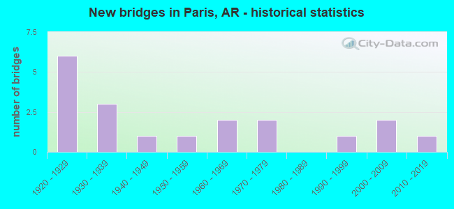
- New bridges - historical statistics
- 61920-1929
- 31930-1939
- 11940-1949
- 11950-1959
- 21960-1969
- 21970-1979
- 11990-1999
- 22000-2009
- 12010-2019

- Reconstructed bridges - Historical Statistics
- 41950-1959
- 11960-1969
- 11970-1979
- 01980-1989
- 01990-1999
- 02000-2009
- 12010-2019


- Bridge Condition - Deck
- 13.3%Good
- 60.0%Satisfactory
- 26.7%Fair

- Bridge Condition - Superstructure
- 6.7%Very good
- 53.3%Satisfactory
- 13.3%Fair
- 26.7%Poor

- Bridge Condition - Substructure
- 6.7%Very good
- 6.7%Good
- 40.0%Satisfactory
- 46.7%Fair

- Bridge Condition - Channel
- 10.5%Very good
- 26.3%Good
- 52.6%Satisfactory
- 10.5%Fair

- Bridge Condition - Culverts
- 25.0%Very good
- 25.0%Good
- 50.0%Satisfactory
Find on map >> Show street view
Structure Number: 378, Location: 6.64 MI E of Franklin Co. (Lat: 35.297158, Lng: -93.803078), Route carried "on" structure: State highway 22, Year Built: 1928, Year Reconstructed: 1957, Status: Open, Structure Length: 0.91m (2.99ft), Average Daily Traffic: 4,800 (year 2018), Truck Traffic: 7%, Average Future Daily Traffic: 6,309 (year 2028), Design Load: H 20, Features Intersected: Gack Creek-Logan Co.
Minimum Vertical Clearance: 30+ m (98+ ft), Kilometerpoint: 10.684, Lanes on structure: 2, Base Highway Network: Yes, Owner: State Highway Agency, Approaching Roadway Width: 12.2m (40.0ft), Skew: 3 degrees, Material/Design: Concrete, Design/Construction: Tee Beam, Number Of Spans In Main Unit: 1, Length of Maximum Span: 9.1m (29.9ft), Curb-To-Curb Width: 12.2m (40.0ft), Out-to-Out Width: 12.8m (42.0ft)
Condition: Deck: Good, Superstructure: Satisfactory, Substructure: Satisfactory, Channel: Satisfactory, Operating Rating: 54.4 metric tons, Method Used To Determine Operating Rating: Load Factor (LF), Inventory Rating: 32.7 metric tons, Method Used To Determine Inventory Rating: Load Factor (LF), Structural Evaluation: Equal to present minimum criteria, Deck Geometry: Equal to present minimum criteria, Waterway Adequacy: Equal to present desirable criteria, Approach Roadway Alignment: Equal to present desirable criteria, Designated Inspection Frequency: Every 24 months, Critical Feature Inspection Frequency: Every 24 months, Inspection Date: May 2020, Deck Structure Type: Concrete Cast-file-Place, Wearing Surface/Protective System: Wearing Surface: Bituminous
Find on map >> Show street view
Structure Number: 381, Location: 10.19 MI E OF FRANKLIN CO (Lat: 35.292178, Lng: -93.741389), Route carried "on" structure: State highway 22, Year Built: 1928, Year Reconstructed: 1957, Status: Open, Structure Length: 0.91m (2.99ft), Average Daily Traffic: 7,000 (year 2018), Truck Traffic: 1%, Average Future Daily Traffic: 10,067 (year 2028), Design Load: H 20, Features Intersected: Mine Brook-Logan Co.
Minimum Vertical Clearance: 30+ m (98+ ft), Kilometerpoint: 16.396, Lanes on structure: 2, Base Highway Network: Yes, Owner: State Highway Agency, Approaching Roadway Width: 12.2m (40.0ft), Material/Design: Concrete, Design/Construction: Tee Beam, Number Of Spans In Main Unit: 1, Length of Maximum Span: 8.5m (27.9ft), Curb-To-Curb Width: 12.2m (40.0ft), Out-to-Out Width: 12.8m (42.0ft)
Condition: Deck: Satisfactory, Superstructure: Satisfactory, Substructure: Satisfactory, Channel: Good, Operating Rating: 54.4 metric tons, Method Used To Determine Operating Rating: Load Factor (LF), Inventory Rating: 32.7 metric tons, Method Used To Determine Inventory Rating: Load Factor (LF), Structural Evaluation: Equal to present minimum criteria, Deck Geometry: Somewhat better than minimum adequacy, Waterway Adequacy: Equal to present desirable criteria, Approach Roadway Alignment: Equal to present desirable criteria, Designated Inspection Frequency: Every 24 months, Critical Feature Inspection Frequency: Every 24 months, Inspection Date: May 2020, Deck Structure Type: Concrete Cast-file-Place, Wearing Surface/Protective System: Wearing Surface: Bituminous
Find on map >> Show street view
Structure Number: 382, Location: 10.35 MI E OF FRANKLIN CO (Lat: 35.292069, Lng: -93.738489), Route carried "on" structure: State highway 22, Year Built: 1928, Year Reconstructed: 1957, Status: Open, Structure Length: 7.99m (26.21ft), Average Daily Traffic: 7,000 (year 2018), Truck Traffic: 1%, Average Future Daily Traffic: 10,067 (year 2028), Design Load: H 20, Features Intersected: Short Mountain Creek
Minimum Vertical Clearance: 30+ m (98+ ft), Kilometerpoint: 16.654, Lanes on structure: 2, Base Highway Network: Yes, Owner: State Highway Agency, Approaching Roadway Width: 12.2m (40.0ft), Material/Design: Steel, Design/Construction: Stringer/Multi-beam, Number Of Spans In Main Unit: 1, Number Of Approach Spans: 6, Length of Maximum Span: 25.0m (82.0ft), Curb or Sidewalk Widths: Left: 0.5m (1.6ft), Right: 0.5m (1.6ft), Curb-To-Curb Width: 8.5m (27.9ft), Out-to-Out Width: 9.4m (30.8ft)
Condition: Deck: Satisfactory, Superstructure: Poor, Substructure: Fair, Channel: Good, Operating Rating: 39.0 metric tons, Method Used To Determine Operating Rating: Load Factor (LF), Inventory Rating: 23.6 metric tons, Method Used To Determine Inventory Rating: Load Factor (LF), Structural Evaluation: Meets minimum limits, Deck Geometry: Meets minimum limits, Waterway Adequacy: Equal to present desirable criteria, Approach Roadway Alignment: Equal to present desirable criteria, Designated Inspection Frequency: Every 24 months, Critical Feature Inspection Frequency: Every 24 months, Other Special Inspection Frequency: Every 24 months, Inspection Date: May 2020, Other Special Inspection Date: April 2021, Deck Structure Type: Concrete Cast-file-Place, Wearing Surface/Protective System: Wearing Surface: Bituminous
Find on map >> Show street view
Structure Number: 398, Location: 2.8 MI NE JCT SH 288 &309 (Lat: 35.348689, Lng: -93.748289), Route carried "on" structure: State highway 309, Year Built: 1966, Year Reconstructed: 2017, Status: Open, Structure Length: 6.77m (22.21ft), Average Daily Traffic: 1,300 (year 2018), Truck Traffic: 13%, Average Future Daily Traffic: 1,611 (year 2028), Design Load: H 15, Features Intersected: Six Mile Creek-Logan Co.
Minimum Vertical Clearance: 30+ m (98+ ft), Kilometerpoint: 6.532, Lanes on structure: 2, Owner: State Highway Agency, Approaching Roadway Width: 7.3m (24.0ft), Material/Design: Steel, Design/Construction: Stringer/Multi-beam, Number Of Spans In Main Unit: 5, Length of Maximum Span: 13.4m (44.0ft), Curb or Sidewalk Widths: Left: 0.5m (1.6ft), Right: 0.5m (1.6ft), Curb-To-Curb Width: 7.3m (24.0ft), Out-to-Out Width: 9.1m (29.9ft)
Condition: Deck: Fair, Superstructure: Satisfactory, Substructure: Satisfactory, Channel: Very good, Operating Rating: 36.3 metric tons, Method Used To Determine Operating Rating: Load Factor (LF), Inventory Rating: 28.1 metric tons, Method Used To Determine Inventory Rating: Load Factor (LF), Structural Evaluation: Equal to present minimum criteria, Deck Geometry: Meets minimum limits, Waterway Adequacy: Equal to present desirable criteria, Approach Roadway Alignment: Better than present minimum criteria, Length Of Structure Improvement: 6.77m (22.21ft), Designated Inspection Frequency: Every 24 months, Critical Feature Inspection Frequency: Every 24 months, Inspection Date: September 2021, Total Project Cost: $297,000, Deck Structure Type: Concrete Cast-file-Place, Wearing Surface/Protective System: Wearing Surface: Monolithic Concrete
Find on map >> Show street view
Structure Number: 4344, Location: 2.38 MI N SH 22 (Lat: 35.330417, Lng: -93.791167), Route carried "on" structure: County highway 65, Year Built: 1978, Status: Open, Structure Length: 5.85m (19.19ft), Average Daily Traffic: 490 (year 2018), Truck Traffic: 1%, Average Future Daily Traffic: 83 (year 2007), Design Load: H 15, Features Intersected: Six Mile Creek-Logan Co., Facility Carried by Structure: N Carbon City Road
Minimum Vertical Clearance: 30+ m (98+ ft), Kilometerpoint: 3.829, Lanes on structure: 2, Owner: County Highway Agency, Approaching Roadway Width: 7.3m (24.0ft), Skew: 2 degrees, Material/Design: Steel, Design/Construction: Stringer/Multi-beam, Number Of Spans In Main Unit: 3, Length of Maximum Span: 27.4m (89.9ft), Curb-To-Curb Width: 7.3m (24.0ft), Out-to-Out Width: 8.2m (26.9ft)
Condition: Deck: Good, Superstructure: Very good, Substructure: Very good, Channel: Very good, Operating Rating: 49.9 metric tons, Method Used To Determine Operating Rating: Load Factor (LF), Inventory Rating: 29.9 metric tons, Method Used To Determine Inventory Rating: Load Factor (LF), Structural Evaluation: Better than present minimum criteria, Deck Geometry: Meets minimum limits, Waterway Adequacy: Equal to present desirable criteria, Approach Roadway Alignment: Better than present minimum criteria, Designated Inspection Frequency: Every 24 months, Critical Feature Inspection Frequency: Every 24 months, Inspection Date: October 2020, Deck Structure Type: Concrete Cast-file-Place, Wearing Surface/Protective System: Wearing Surface: Monolithic Concrete
Find on map >> Show street view
Structure Number: 14804, Location: 0.45 MI W SH 309 (Lat: 35.309661, Lng: -93.743331), Route carried "on" structure: County highway 64, Year Built: 1928, Year Reconstructed: 1976, Status: Posted for load, Structure Length: 2.83m (9.28ft), Average Daily Traffic: 50 (year 2018), Truck Traffic: 2%, Average Future Daily Traffic: 40 (year 2007), Design Load: H 15, Features Intersected: Short Mountain Creek
Minimum Vertical Clearance: 30+ m (98+ ft), Kilometerpoint: 0.917, Lanes on structure: 2, Owner: County Highway Agency, Approaching Roadway Width: 5.5m (18.0ft), Material/Design: Steel, Design/Construction: Truss - Thru, Number Of Spans In Main Unit: 1, Length of Maximum Span: 28.0m (91.9ft), Curb-To-Curb Width: 5.8m (19.0ft), Out-to-Out Width: 6.6m (21.7ft)
Condition: Deck: Satisfactory, Superstructure: Poor, Substructure: Fair, Channel: Satisfactory, Operating Rating: 13.8 metric tons, Method Used To Determine Operating Rating: Load Factor (LF), Inventory Rating: 8.3 metric tons, Method Used To Determine Inventory Rating: Load Factor (LF), Structural Evaluation: High priority of replacement, Deck Geometry: Meets minimum limits, Waterway Adequacy: Somewhat better than minimum adequacy, Approach Roadway Alignment: Somewhat better than minimum adequacy, Bridge Posting: Required (Relationship of Operating Rating to Maximum Legal Load: > 39.9% below), Length Of Structure Improvement: 3.66m (12.01ft), Designated Inspection Frequency: Every 24 months, Critical Feature Inspection Frequency: Every 24 months, Inspection Date: October 2021, Critical Feature Inspection Date: October 2021, Roadway Improvement Cost: $109,000, Total Project Cost: $309,000, Deck Structure Type: Concrete Cast-file-Place, Wearing Surface/Protective System: Wearing Surface: Monolithic Concrete
Find on map >> Show street view
Structure Number: 14814, Location: 3.3 MI E SH 309 (Lat: 35.309722, Lng: -93.675778), Route carried "on" structure: County highway 68, Year Built: 1942, Status: Open, Structure Length: 1.25m (4.10ft), Average Daily Traffic: 270 (year 2017), Truck Traffic: 1%, Average Future Daily Traffic: 138 (year 2007), Design Load: H 15, Features Intersected: Hegwood Creek Logan Co., Facility Carried by Structure: Old Military Road
Minimum Vertical Clearance: 30+ m (98+ ft), Kilometerpoint: 20.868, Lanes on structure: 2, Owner: County Highway Agency, Approaching Roadway Width: 6.7m (22.0ft), Skew: 4 degrees, Material/Design: Concrete, Design/Construction: Slab, Number Of Spans In Main Unit: 2, Length of Maximum Span: 6.4m (21.0ft), Curb or Sidewalk Widths: Left: 0.3m (1.0ft), Right: 0.3m (1.0ft), Curb-To-Curb Width: 6.7m (22.0ft), Out-to-Out Width: 7.3m (24.0ft)
Condition: Deck: Satisfactory, Superstructure: Satisfactory, Substructure: Good, Channel: Satisfactory, Operating Rating: 35.4 metric tons, Method Used To Determine Operating Rating: Load Factor (LF), Inventory Rating: 21.8 metric tons, Method Used To Determine Inventory Rating: Load Factor (LF), Structural Evaluation: Equal to present minimum criteria, Deck Geometry: Meets minimum limits, Waterway Adequacy: Equal to present minimum criteria, Approach Roadway Alignment: Equal to present minimum criteria, Designated Inspection Frequency: Every 24 months, Critical Feature Inspection Frequency: Every 24 months, Inspection Date: December 2020, Deck Structure Type: Concrete Cast-file-Place, Wearing Surface/Protective System: Wearing Surface: Monolithic Concrete
Find on map >> Show street view
Structure Number: 14815, Location: 1.45 MI NO SH 22 (Lat: 35.315831, Lng: -93.686111), Route carried "on" structure: County highway 71, Year Built: 1935, Year Reconstructed: 1960, Status: Open, Structure Length: 1.46m (4.79ft), Average Daily Traffic: 44 (year 2018), Truck Traffic: 1%, Average Future Daily Traffic: 125 (year 2007), Design Load: H 15, Features Intersected: Hegwood Creek-Logan Co.
Minimum Vertical Clearance: 30+ m (98+ ft), Kilometerpoint: 2.285, Lanes on structure: 1, Owner: County Highway Agency, Approaching Roadway Width: 4.3m (14.1ft), Material/Design: Steel, Design/Construction: Stringer/Multi-beam, Number Of Spans In Main Unit: 3, Length of Maximum Span: 5.5m (18.0ft), Curb or Sidewalk Widths: Left: 0.1m (0.3ft), Right: 0.1m (0.3ft), Curb-To-Curb Width: 4.1m (13.5ft), Out-to-Out Width: 4.3m (14.1ft)
Condition: Deck: Fair, Superstructure: Poor, Substructure: Fair, Channel: Fair, Operating Rating: 54.4 metric tons, Method Used To Determine Operating Rating: Load Factor (LF), Inventory Rating: 32.7 metric tons, Method Used To Determine Inventory Rating: Load Factor (LF), Structural Evaluation: Meets minimum limits, Deck Geometry: Somewhat better than minimum adequacy, Waterway Adequacy: Equal to present minimum criteria, Approach Roadway Alignment: Equal to present minimum criteria, Length Of Structure Improvement: 1.46m (4.79ft), Designated Inspection Frequency: Every 24 months, Other Special Inspection Frequency: Every 24 months, Inspection Date: August 2021, Other Special Inspection Date: August 2020, Total Project Cost: $29,000, Deck Structure Type: Open Grating, Wearing Surface/Protective System: Wearing Surface: Other
Find on map >> Show street view
Structure Number: 14818, Location: 1.8 MI N SH 22 (Lat: 35.321619, Lng: -93.702639), Route carried "on" structure: County highway 74, Year Built: 1966, Status: Posted for load, Structure Length: 3.26m (10.70ft), Average Daily Traffic: 237 (year 2018), Truck Traffic: 1%, Average Future Daily Traffic: 325 (year 2007), Design Load: H 15, Features Intersected: Hegwood Creek-Logan Co., Facility Carried by Structure: Kalamazoo Rd.
Minimum Vertical Clearance: 30+ m (98+ ft), Kilometerpoint: 4.265, Lanes on structure: 2, Owner: County Highway Agency, Approaching Roadway Width: 6.1m (20.0ft), Material/Design: Steel, Design/Construction: Stringer/Multi-beam, Number Of Spans In Main Unit: 3, Length of Maximum Span: 10.7m (35.1ft), Curb or Sidewalk Widths: Left: 0.3m (1.0ft), Right: 0.3m (1.0ft), Curb-To-Curb Width: 6.1m (20.0ft), Out-to-Out Width: 6.7m (22.0ft)
Condition: Deck: Satisfactory, Superstructure: Satisfactory, Substructure: Satisfactory, Channel: Satisfactory, Operating Rating: 30.8 metric tons, Method Used To Determine Operating Rating: Load Factor (LF), Inventory Rating: 18.1 metric tons, Method Used To Determine Inventory Rating: Load Factor (LF), Structural Evaluation: Somewhat better than minimum adequacy, Deck Geometry: Meets minimum limits, Waterway Adequacy: Equal to present desirable criteria, Approach Roadway Alignment: Equal to present desirable criteria, Bridge Posting: Required (Relationship of Operating Rating to Maximum Legal Load: 20.0 - 29.9% below), Designated Inspection Frequency: Every 24 months, Critical Feature Inspection Frequency: Every 24 months, Inspection Date: August 2021, Deck Structure Type: Concrete Cast-file-Place, Wearing Surface/Protective System: Wearing Surface: Monolithic Concrete
Find on map >> Show street view
Structure Number: 14845, Location: 0.36 MI W SH 309 (Lat: 35.267778, Lng: -93.688278), Route carried "on" structure: County highway 702, Year Built: 1930, Status: Posted for load, Structure Length: 1.71m (5.61ft), Average Daily Traffic: 135 (year 2018), Truck Traffic: 1%, Average Future Daily Traffic: 54 (year 2007), Design Load: H 15, Features Intersected: Short Mountain Creek, Facility Carried by Structure: Johnson Road-Logan
Minimum Vertical Clearance: 30+ m (98+ ft), Kilometerpoint: 0.579, Lanes on structure: 1, Owner: County Highway Agency, Approaching Roadway Width: 5.5m (18.0ft), Material/Design: Steel, Design/Construction: Stringer/Multi-beam, Number Of Spans In Main Unit: 1, Length of Maximum Span: 14.6m (47.9ft), Curb-To-Curb Width: 4.4m (14.4ft), Out-to-Out Width: 4.5m (14.8ft)
Condition: Deck: Satisfactory, Superstructure: Fair, Substructure: Fair, Channel: Satisfactory, Operating Rating: 27.2 metric tons, Method Used To Determine Operating Rating: Load Factor (LF), Inventory Rating: 16.3 metric tons, Method Used To Determine Inventory Rating: Load Factor (LF), Structural Evaluation: Somewhat better than minimum adequacy, Deck Geometry: High priority of replacement, Waterway Adequacy: Equal to present desirable criteria, Approach Roadway Alignment: High priority of corrective action, Bridge Posting: Required (Relationship of Operating Rating to Maximum Legal Load: > 39.9% below), Length Of Structure Improvement: 1.71m (5.61ft), Designated Inspection Frequency: Every 24 months, Critical Feature Inspection Frequency: Every 24 months, Inspection Date: August 2021, Total Project Cost: $36,000, Deck Structure Type: Aluminum, Wearing Surface/Protective System: Wearing Surface: Other
Find on map >> Show street view
Structure Number: 14848, Location: .01 MI E SH 109 (Lat: 35.243056, Lng: -93.772500), Route carried "on" structure: County highway 731, Year Built: 1973, Status: Open, Structure Length: 0.91m (2.99ft), Average Daily Traffic: 36 (year 2018), Truck Traffic: 1%, Average Future Daily Traffic: 67 (year 2006), Features Intersected: Chigger Creek-Logan Co., Facility Carried by Structure: Daniels Lane
Minimum Vertical Clearance: 30+ m (98+ ft), Kilometerpoint: 0.016, Lanes on structure: 1, Owner: County Highway Agency, Approaching Roadway Width: 4.6m (15.1ft), Material/Design: Steel, Design/Construction: Stringer/Multi-beam, Number Of Spans In Main Unit: 1, Length of Maximum Span: 8.2m (26.9ft), Curb or Sidewalk Widths: Left: 0.1m (0.3ft), Right: 0.1m (0.3ft), Curb-To-Curb Width: 4.0m (13.1ft), Out-to-Out Width: 4.1m (13.5ft)
Condition: Deck: Satisfactory, Superstructure: Fair, Substructure: Satisfactory, Channel: Satisfactory, Operating Rating: 39.0 metric tons, Method Used To Determine Operating Rating: Load Factor (LF), Inventory Rating: 23.6 metric tons, Method Used To Determine Inventory Rating: Load Factor (LF), Structural Evaluation: Somewhat better than minimum adequacy, Deck Geometry: Somewhat better than minimum adequacy, Waterway Adequacy: Somewhat better than minimum adequacy, Approach Roadway Alignment: High priority of corrective action, Length Of Structure Improvement: 0.91m (2.99ft), Designated Inspection Frequency: Every 24 months, Other Special Inspection Frequency: Every 24 months, Inspection Date: January 2021, Other Special Inspection Date: January 2022, Total Project Cost: $17,000, Deck Structure Type: Open Grating, Wearing Surface/Protective System: Wearing Surface: Other
Find on map >> Show street view
Structure Number: 19257, Location: 0.12 MI N SH 22 (Lat: 35.293917, Lng: -93.732389), Route carried "on" structure: City street 50030, Year Built: 1935, Status: Posted for load, Structure Length: 1.40m (4.59ft), Average Daily Traffic: 416 (year 2018), Truck Traffic: 1%, Average Future Daily Traffic: 537 (year 2007), Features Intersected: West Creek-Logan Co., Facility Carried by Structure: N Roseville- Paris
Minimum Vertical Clearance: 30+ m (98+ ft), Kilometerpoint: 0.193, Lanes on structure: 1, Owner: City or Municipal Highway Agency, Approaching Roadway Width: 6.1m (20.0ft), Skew: 1 degrees, Material/Design: Steel, Design/Construction: Truss - Thru, Number Of Spans In Main Unit: 2, Length of Maximum Span: 9.4m (30.8ft), Curb-To-Curb Width: 5.3m (17.4ft), Out-to-Out Width: 5.8m (19.0ft)
Condition: Deck: Fair, Superstructure: Poor, Substructure: Fair, Channel: Fair, Operating Rating: 2.7 metric tons, Method Used To Determine Operating Rating: Allowable Stress (AS), Structural Evaluation: High priority of replacement, Deck Geometry: High priority of replacement, Waterway Adequacy: Equal to present minimum criteria, Approach Roadway Alignment: Somewhat better than minimum adequacy, Bridge Posting: Required (Relationship of Operating Rating to Maximum Legal Load: > 39.9% below), Length Of Structure Improvement: 2.13m (6.99ft), Designated Inspection Frequency: Every 24 months, Critical Feature Inspection Frequency: Every 24 months, Inspection Date: April 2021, Critical Feature Inspection Date: April 2021, Roadway Improvement Cost: $109,000, Total Project Cost: $237,000, Deck Structure Type: Concrete Cast-file-Place, Wearing Surface/Protective System: Wearing Surface: Monolithic Concrete
Find on map >> Show street view
Structure Number: 2145, Location: 1.75 S E DRIGGS (Lat: 35.221553, Lng: -93.745278), Route carried "on" structure: County highway 40, Year Built: 1993, Status: Open, Structure Length: 1.22m (4.00ft), Average Daily Traffic: 221 (year 2018), Average Future Daily Traffic: 123 (year 2007), Features Intersected: Chigger Creek-Logan Co., Facility Carried by Structure: Reveille Valley Rd
Minimum Vertical Clearance: 30+ m (98+ ft), Kilometerpoint: 2.589, Lanes on structure: 2, Owner: County Highway Agency, Approaching Roadway Width: 7.3m (24.0ft), Material/Design: Concrete, Design/Construction: Channel Beam, Number Of Spans In Main Unit: 2, Length of Maximum Span: 5.5m (18.0ft), Curb or Sidewalk Widths: Left: 0.2m (0.7ft), Right: 0.2m (0.7ft), Curb-To-Curb Width: 7.2m (23.6ft), Out-to-Out Width: 7.5m (24.6ft)
Condition: Deck: Fair, Superstructure: Satisfactory, Substructure: Fair, Channel: Good, Operating Rating: 32.7 metric tons, Method Used To Determine Operating Rating: Load Factor (LF), Inventory Rating: 20.0 metric tons, Method Used To Determine Inventory Rating: Load Factor (LF), Structural Evaluation: Somewhat better than minimum adequacy, Deck Geometry: Meets minimum limits, Waterway Adequacy: Equal to present desirable criteria, Approach Roadway Alignment: Equal to present desirable criteria, Designated Inspection Frequency: Every 24 months, Critical Feature Inspection Frequency: Every 24 months, Inspection Date: May 2020, Deck Structure Type: Concrete Precast Panels, Wearing Surface/Protective System: Wearing Surface: Monolithic Concrete
Find on map >> Show street view
Structure Number: 23171, Location: 3.12 Mi SW SH 309 (Lat: 35.312333, Lng: -93.787222), Route carried "on" structure: County highway 64, Year Built: 2008, Status: Posted for load, Structure Length: 1.89m (6.20ft), Average Daily Traffic: 50 (year 2018), Truck Traffic: 2%, Average Future Daily Traffic: 27 (year 2007), Features Intersected: Three Mile Creek-Logan, Facility Carried by Structure: Short Mountain Rd.
Minimum Vertical Clearance: 30+ m (98+ ft), Kilometerpoint: 5.311, Lanes on structure: 1, Owner: County Highway Agency, Approaching Roadway Width: 6.1m (20.0ft), Material/Design: Steel, Design/Construction: Orthotropic, Number Of Spans In Main Unit: 1, Length of Maximum Span: 17.7m (58.1ft), Curb or Sidewalk Widths: Left: 0.2m (0.7ft), Right: 0.2m (0.7ft), Curb-To-Curb Width: 5.1m (16.7ft), Out-to-Out Width: 5.5m (18.0ft)
Condition: Deck: Satisfactory, Superstructure: Satisfactory, Substructure: Fair, Channel: Good, Operating Rating: 23.6 metric tons, Method Used To Determine Operating Rating: Load Factor (LF), Inventory Rating: 13.6 metric tons, Method Used To Determine Inventory Rating: Load Factor (LF), Structural Evaluation: Meets minimum limits, Deck Geometry: High priority of corrective action, Waterway Adequacy: Meets minimum limits, Approach Roadway Alignment: Better than present minimum criteria, Bridge Posting: Required (Relationship of Operating Rating to Maximum Legal Load: 30.0 - 39.9% below), Designated Inspection Frequency: Every 24 months, Critical Feature Inspection Frequency: Every 24 months, Inspection Date: August 2021, Critical Feature Inspection Date: August 2021, Deck Structure Type: Steel plate, Wearing Surface/Protective System: Wearing Surface: Other
Find on map >> Show street view
Structure Number: 23474, Location: 0.53 Mi. N. Hwy. 22 (Lat: 35.305528, Lng: -93.791806), Route carried "on" structure: County highway 65, Year Built: 2011, Status: Open, Structure Length: 0.84m (2.76ft), Average Daily Traffic: 620 (year 2018), Truck Traffic: 1%, Average Future Daily Traffic: 83 (year 2007), Features Intersected: Ditch - Logan Co., Facility Carried by Structure: N. Carbon City Rd.
Minimum Vertical Clearance: 30+ m (98+ ft), Kilometerpoint: 0.853, Lanes on structure: 2, Owner: County Highway Agency, Approaching Roadway Width: 6.7m (22.0ft), Material/Design: Concrete, Design/Construction: Culvert, Number Of Spans In Main Unit: 3, Length of Maximum Span: 2.4m (7.9ft)
Condition: Channel: Good, Culverts: Very good, Operating Rating: 53.5 metric tons, Method Used To Determine Operating Rating: Load Factor (LF), Inventory Rating: 31.8 metric tons, Method Used To Determine Inventory Rating: Load Factor (LF), Structural Evaluation: Better than present minimum criteria, Waterway Adequacy: Equal to present desirable criteria, Approach Roadway Alignment: Equal to present desirable criteria, Designated Inspection Frequency: Every 24 months, Critical Feature Inspection Frequency: Every 24 months, Inspection Date: May 2021
Find on map >> Show street view
Structure Number: A0487, Location: 3 MI EAST JCT 309 @ PARIS (Lat: 35.295019, Lng: -93.678378), Route carried "on" structure: State highway 22, Year Built: 1928, Year Reconstructed: 1963, Status: Open, Structure Length: 0.91m (2.99ft), Average Daily Traffic: 7,589 (year 2015), Truck Traffic: 1%, Average Future Daily Traffic: 7,114 (year 2028), Design Load: H 20, Features Intersected: Hagwood Creek-Logan Co.
Minimum Vertical Clearance: 30+ m (98+ ft), Kilometerpoint: 22.172, Lanes on structure: 2, Base Highway Network: Yes, Owner: State Highway Agency, Approaching Roadway Width: 12.2m (40.0ft), Material/Design: Concrete, Design/Construction: Tee Beam, Number Of Spans In Main Unit: 1, Length of Maximum Span: 9.1m (29.9ft), Curb or Sidewalk Widths: Left: 0.2m (0.7ft), Right: 0.2m (0.7ft), Curb-To-Curb Width: 12.3m (40.4ft), Out-to-Out Width: 13.0m (42.7ft)
Condition: Deck: Satisfactory, Superstructure: Satisfactory, Substructure: Satisfactory, Channel: Satisfactory, Operating Rating: 39.9 metric tons, Method Used To Determine Operating Rating: Load Factor (LF), Inventory Rating: 23.6 metric tons, Method Used To Determine Inventory Rating: Load Factor (LF), Structural Evaluation: Somewhat better than minimum adequacy, Deck Geometry: Somewhat better than minimum adequacy, Waterway Adequacy: Equal to present desirable criteria, Approach Roadway Alignment: Better than present minimum criteria, Length Of Structure Improvement: 0.91m (2.99ft), Designated Inspection Frequency: Every 24 months, Critical Feature Inspection Frequency: Every 24 months, Inspection Date: May 2020, Total Project Cost: $57,000, Deck Structure Type: Concrete Cast-file-Place, Wearing Surface/Protective System: Wearing Surface: Bituminous
Find on map >> Show street view
Structure Number: M177, Location: 7.87 MI N SH 10 (Lat: 35.237669, Lng: -93.772889), Route carried "on" structure: State highway 109, Year Built: 1952, Status: Open, Structure Length: 0.79m (2.59ft), Average Daily Traffic: 1,750 (year 2018), Truck Traffic: 3%, Average Future Daily Traffic: 2,013 (year 2028), Design Load: H 15, Features Intersected: Creek-Logan Co.
Minimum Vertical Clearance: 30+ m (98+ ft), Kilometerpoint: 12.662, Lanes on structure: 2, Owner: State Highway Agency, Approaching Roadway Width: 8.5m (27.9ft), Material/Design: Concrete, Design/Construction: Culvert, Number Of Spans In Main Unit: 3, Length of Maximum Span: 2.7m (8.9ft), Curb-To-Curb Width: 9.8m (32.2ft), Out-to-Out Width: 10.4m (34.1ft)
Condition: Channel: Satisfactory, Culverts: Satisfactory, Operating Rating: 50.8 metric tons, Method Used To Determine Operating Rating: Load Factor (LF), Inventory Rating: 30.8 metric tons, Method Used To Determine Inventory Rating: Load Factor (LF), Structural Evaluation: Equal to present minimum criteria, Deck Geometry: Somewhat better than minimum adequacy, Waterway Adequacy: Better than present minimum criteria, Approach Roadway Alignment: Better than present minimum criteria, Designated Inspection Frequency: Every 24 months, Critical Feature Inspection Frequency: Every 24 months, Inspection Date: May 2020
Find on map >> Show street view
Structure Number: M1771, Location: 0.2 Mi S Jct Hwy 22 PARIS (Lat: 35.289628, Lng: -93.729969), Route carried "on" structure: State highway 109, Year Built: 1928, Status: Open, Structure Length: 1.58m (5.18ft), Average Daily Traffic: 4,300 (year 2018), Truck Traffic: 1%, Average Future Daily Traffic: 6,711 (year 2028), Design Load: H 15, Features Intersected: Creek - Logan Co.
Minimum Vertical Clearance: 30+ m (98+ ft), Kilometerpoint: 23.078, Lanes on structure: 2, Owner: State Highway Agency, Approaching Roadway Width: 9.1m (29.9ft), Skew: 7 degrees, Material/Design: Concrete, Design/Construction: Culvert, Number Of Spans In Main Unit: 2, Length of Maximum Span: 7.3m (24.0ft), Curb or Sidewalk Widths: Left: 2.4m (7.9ft), Right: 2.7m (8.9ft), Curb-To-Curb Width: 9.1m (29.9ft), Out-to-Out Width: 14.6m (47.9ft)
Condition: Channel: Satisfactory, Culverts: Satisfactory, Operating Rating: 38.1 metric tons, Method Used To Determine Operating Rating: Load Factor (LF), Inventory Rating: 22.7 metric tons, Method Used To Determine Inventory Rating: Load Factor (LF), Structural Evaluation: Equal to present minimum criteria, Deck Geometry: Meets minimum limits, Waterway Adequacy: Equal to present minimum criteria, Approach Roadway Alignment: Equal to present desirable criteria, Designated Inspection Frequency: Every 24 months, Critical Feature Inspection Frequency: Every 24 months, Inspection Date: May 2020
Find on map >> Show street view
Structure Number: X1093, Location: CARBON CITY (Lat: 35.297194, Lng: -93.784056), Route carried "on" structure: State highway 22, Year Built: 2002, Status: Open, Structure Length: 1.68m (5.51ft), Average Daily Traffic: 4,800 (year 2018), Truck Traffic: 7%, Average Future Daily Traffic: 6,309 (year 2028), Design Load: H 20, Features Intersected: Anderson Creek
Minimum Vertical Clearance: 30+ m (98+ ft), Kilometerpoint: 12.424, Lanes on structure: 2, Base Highway Network: Yes, Owner: State Highway Agency, Approaching Roadway Width: 11.0m (36.1ft), Material/Design: Concrete, Design/Construction: Culvert, Number Of Spans In Main Unit: 5, Length of Maximum Span: 3.4m (11.2ft)
Condition: Channel: Satisfactory, Culverts: Good, Operating Rating: 30.8 metric tons, Method Used To Determine Operating Rating: Load Factor (LF), Inventory Rating: 18.1 metric tons, Method Used To Determine Inventory Rating: Load Factor (LF), Structural Evaluation: Somewhat better than minimum adequacy, Waterway Adequacy: Equal to present desirable criteria, Approach Roadway Alignment: Equal to present desirable criteria, Designated Inspection Frequency: Every 24 months, Critical Feature Inspection Frequency: Every 24 months, Inspection Date: August 2021