Bridge Statistics for Pesotum, Illinois (IL)
Condition, Traffic, Stress, Structural Evaluation, Project Costs
- National Bridge Inventory (NBI) Statistics
- 23Number of bridges
- 187ft / 57.4mTotal length
- $933,000Total costs
- 126,310Total average daily traffic
- 39,142Total average daily truck traffic
- National Bridge Inventory (NBI) Registered Bridges for Pesotum
- No street view available for this location
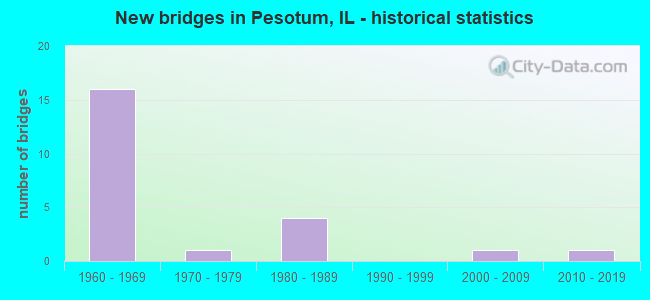
- New bridges - historical statistics
- 161960-1969
- 11970-1979
- 41980-1989
- 12000-2009
- 12010-2019

- Reconstructed bridges - Historical Statistics
- 21990-1999
- 12000-2009


- Bridge Condition - Deck
- 12.5%Very good
- 56.3%Good
- 18.8%Satisfactory
- 12.5%Fair

- Bridge Condition - Superstructure
- 12.5%Very good
- 43.8%Good
- 31.3%Satisfactory
- 6.3%Serious
- 6.3%Critical

- Bridge Condition - Substructure
- 31.3%Very good
- 50.0%Good
- 18.8%Satisfactory

- Bridge Condition - Channel
- 40.0%Very good
- 60.0%Good
Find on map >> Show street view
Structure Number: 100145, Location: 1 MI W OF PESOTUM (Lat: 39.915547, Lng: -88.293661), Route carried "on" structure: County highway , Year Built: 1963, Year Reconstructed: 2000, Status: Open, Structure Length: 9.68m (31.76ft), Average Daily Traffic: 175 (year 2021), Truck Traffic: 1%, Average Future Daily Traffic: 85 (year 2032), Design Load: HS 15, Features Intersected: I-57, Facility Carried by Structure: TR 297 B
Minimum Vertical Clearance: 30+ m (98+ ft), Kilometerpoint: 6.067, Lanes on structure: 2, Lanes under structure: 4, Owner: State Highway Agency, Approaching Roadway Width: 6.7m (22.0ft), Skew: 4 degrees, Material/Design: Steel continuous, Design/Construction: Stringer/Multi-beam, Number Of Spans In Main Unit: 4, Length of Maximum Span: 29.9m (98.1ft), Curb-To-Curb Width: 8.5m (27.9ft), Out-to-Out Width: 9.5m (31.2ft)
Condition: Deck: Good, Superstructure: Satisfactory, Substructure: Good, Operating Rating: 59.9 metric tons, Method Used To Determine Operating Rating: Load Factor (LF) rating reported by rating factor (RF) method using MS18 loading, Inventory Rating: 36.0 metric tons, Method Used To Determine Inventory Rating: Load Factor (LF) rating reported by rating factor (RF) method using MS18 loading, Structural Evaluation: Equal to present minimum criteria, Deck Geometry: Equal to present minimum criteria, Underclear: Meets minimum limits, Approach Roadway Alignment: Equal to present desirable criteria, Length Of Structure Improvement: 9.69m (31.79ft), Designated Inspection Frequency: Every 24 months, Inspection Date: November 2021, Bridge Improvement Cost: $622,000, Roadway Improvement Cost: $62,000, Total Project Cost: $933,000, Deck Structure Type: Concrete Cast-file-Place, Wearing Surface/Protective System: Deck Protection: Epoxy Coated Reinforcing
Find on map >> Show street view
Structure Number: 100181, Location: NW OF PESOTUM (Lat: 39.937289, Lng: -88.303600), Route carried "on" structure: County highway , Year Built: 1965, Status: Open, Structure Length: 6.77m (22.21ft), Average Daily Traffic: 50 (year 2021), Average Future Daily Traffic: 56 (year 2032), Design Load: HS 15, Features Intersected: I-57, Facility Carried by Structure: TR 283
Minimum Vertical Clearance: 30+ m (98+ ft), Kilometerpoint: 3.927, Lanes on structure: 2, Lanes under structure: 4, Owner: State Highway Agency, Approaching Roadway Width: 5.5m (18.0ft), Material/Design: Steel continuous, Design/Construction: Stringer/Multi-beam, Number Of Spans In Main Unit: 4, Length of Maximum Span: 20.5m (67.3ft), Curb or Sidewalk Widths: Left: 0.6m (2.0ft), Right: 0.6m (2.0ft), Curb-To-Curb Width: 7.3m (24.0ft), Out-to-Out Width: 9.1m (29.9ft)
Condition: Deck: Good, Superstructure: Good, Substructure: Good, Operating Rating: 40.5 metric tons, Method Used To Determine Operating Rating: Allowable Stress (AS) rating reported by rating factor (RF) method using MS18 loading, Inventory Rating: 25.3 metric tons, Method Used To Determine Inventory Rating: Allowable Stress (AS) rating reported by rating factor (RF) method using MS18 loading, Structural Evaluation: Equal to present minimum criteria, Deck Geometry: Equal to present minimum criteria, Underclear: Somewhat better than minimum adequacy, Approach Roadway Alignment: Better than present minimum criteria, Designated Inspection Frequency: Every 24 months, Inspection Date: December 2020, Deck Structure Type: Concrete Cast-file-Place
Find on map >> Show street view
Structure Number: 100198, Location: S OF PESOTUM (Lat: 39.905558, Lng: -88.279419), Route carried "on" structure: Interstate 57, Year Built: 1963, Status: Temporarily open, Structure Length: 3.71m (12.17ft), Average Daily Traffic: 12,450 (year 2021), Truck Traffic: 34%, Average Future Daily Traffic: 10,942 (year 2032), Design Load: HS 20+Mod, Features Intersected: FAP 804(US 45)
Minimum Vertical Clearance: 30+ m (98+ ft), Kilometerpoint: 353.644, Lanes on structure: 2, Lanes under structure: 2, Base Highway Network: Yes, Owner: State Highway Agency, Approaching Roadway Width: 11.6m (38.1ft), Material/Design: Steel continuous, Design/Construction: Stringer/Multi-beam, Number Of Spans In Main Unit: 3, Length of Maximum Span: 12.6m (41.3ft), Curb-To-Curb Width: 11.9m (39.0ft), Out-to-Out Width: 13.3m (43.6ft)
Condition: Deck: Satisfactory, Superstructure: Serious, Substructure: Satisfactory, Operating Rating: 49.2 metric tons, Method Used To Determine Operating Rating: Load Factor (LF) rating reported by rating factor (RF) method using MS18 loading, Inventory Rating: 29.5 metric tons, Method Used To Determine Inventory Rating: Load Factor (LF) rating reported by rating factor (RF) method using MS18 loading, Structural Evaluation: High priority of corrective action, Deck Geometry: Equal to present minimum criteria, Underclear: Meets minimum limits, Approach Roadway Alignment: Equal to present desirable criteria, Designated Inspection Frequency: Every 12 months, Inspection Date: November 2021, Deck Structure Type: Concrete Cast-file-Place, Wearing Surface/Protective System: Wearing Surface: Latex Concrete
Find on map >> Show street view
Structure Number: 100199, Location: S OF PESOTUM (Lat: 39.905714, Lng: -88.279636), Route carried "on" structure: Interstate 57, Year Built: 1963, Status: Open, Structure Length: 3.71m (12.17ft), Average Daily Traffic: 12,900 (year 2021), Truck Traffic: 33%, Average Future Daily Traffic: 12,013 (year 2032), Design Load: HS 20+Mod, Features Intersected: US 45(FAS 1671)
Minimum Vertical Clearance: 30+ m (98+ ft), Kilometerpoint: 353.660, Lanes on structure: 2, Lanes under structure: 2, Base Highway Network: Yes, Owner: State Highway Agency, Approaching Roadway Width: 11.6m (38.1ft), Material/Design: Steel continuous, Design/Construction: Stringer/Multi-beam, Number Of Spans In Main Unit: 3, Length of Maximum Span: 12.6m (41.3ft), Curb-To-Curb Width: 11.9m (39.0ft), Out-to-Out Width: 13.3m (43.6ft)
Condition: Deck: Fair, Superstructure: Critical, Substructure: Good, Operating Rating: 49.6 metric tons, Method Used To Determine Operating Rating: Load Factor (LF) rating reported by rating factor (RF) method using MS18 loading, Inventory Rating: 29.8 metric tons, Method Used To Determine Inventory Rating: Load Factor (LF) rating reported by rating factor (RF) method using MS18 loading, Structural Evaluation: High priority of replacement, Deck Geometry: Equal to present minimum criteria, Underclear: Meets minimum limits, Approach Roadway Alignment: Equal to present desirable criteria, Designated Inspection Frequency: Every 12 months, Other Special Inspection Frequency: Every 1 months, Inspection Date: November 2021, Other Special Inspection Date: Febuary 2022, Deck Structure Type: Concrete Cast-file-Place, Wearing Surface/Protective System: Wearing Surface: Latex Concrete
Find on map >> Show street view
Structure Number: 1002, Location: S OF PESOTUM (Lat: 39.901828, Lng: -88.274453), Route carried "on" structure: Interstate 57, Year Built: 1968, Year Reconstructed: 2003, Status: Open, Structure Length: 11.12m (36.48ft), Average Daily Traffic: 12,450 (year 2021), Truck Traffic: 34%, Average Future Daily Traffic: 10,942 (year 2032), Design Load: HS 20+Mod, Features Intersected: IC RR & TR 132
Minimum Vertical Clearance: 30+ m (98+ ft), Kilometerpoint: 353.032, Lanes on structure: 2, Lanes under structure: 2, Base Highway Network: Yes, Owner: State Highway Agency, Approaching Roadway Width: 12.5m (41.0ft), Skew: 3 degrees, Material/Design: Steel continuous, Design/Construction: Stringer/Multi-beam, Number Of Spans In Main Unit: 6, Length of Maximum Span: 22.2m (72.8ft), Curb-To-Curb Width: 12.6m (41.3ft), Out-to-Out Width: 13.6m (44.6ft)
Condition: Deck: Satisfactory, Superstructure: Satisfactory, Substructure: Good, Operating Rating: 89.1 metric tons, Method Used To Determine Operating Rating: Load Factor (LF) rating reported by rating factor (RF) method using MS18 loading, Inventory Rating: 54.8 metric tons, Method Used To Determine Inventory Rating: Load Factor (LF) rating reported by rating factor (RF) method using MS18 loading, Structural Evaluation: Equal to present minimum criteria, Deck Geometry: Better than present minimum criteria, Underclear: Better than present minimum criteria, Approach Roadway Alignment: Equal to present desirable criteria, Designated Inspection Frequency: Every 24 months, Inspection Date: December 2020, Deck Structure Type: Concrete Cast-file-Place, Wearing Surface/Protective System: Deck Protection: Epoxy Coated Reinforcing
Find on map >> Show street view
Structure Number: 100246, Location: .5 MI E OF PESOTUM (Lat: 39.915350, Lng: -88.260694), Route carried "on" structure: County highway , Year Built: 1984, Status: Open, Structure Length: 1.52m (4.99ft), Average Daily Traffic: 100 (year 2021), Truck Traffic: 22%, Average Future Daily Traffic: 141 (year 2032), Design Load: HS 20, Features Intersected: HACKETT BRANCH, Facility Carried by Structure: CH 16(FAS 527)
Minimum Vertical Clearance: 30+ m (98+ ft), Kilometerpoint: 0.402, Lanes on structure: 2, Owner: Town or Township Highway Agency, Approaching Roadway Width: 7.3m (24.0ft), Material/Design: Prestressed concrete, Design/Construction: Box Beam or Girders - Multiple, Number Of Spans In Main Unit: 1, Length of Maximum Span: 14.3m (46.9ft), Curb-To-Curb Width: 9.1m (29.9ft), Out-to-Out Width: 9.1m (29.9ft)
Condition: Deck: Good, Superstructure: Good, Substructure: Very good, Channel: Good, Operating Rating: 59.6 metric tons, Method Used To Determine Operating Rating: Load Factor (LF) rating reported by rating factor (RF) method using MS18 loading, Inventory Rating: 36.9 metric tons, Method Used To Determine Inventory Rating: Load Factor (LF) rating reported by rating factor (RF) method using MS18 loading, Structural Evaluation: Better than present minimum criteria, Deck Geometry: Better than present minimum criteria, Waterway Adequacy: Better than present minimum criteria, Approach Roadway Alignment: Equal to present desirable criteria, Designated Inspection Frequency: Every 48 months, Inspection Date: January 2020, Deck Structure Type: Concrete Precast Panels, Wearing Surface/Protective System: Wearing Surface: Bituminous, Membrane: Built-up
Find on map >> Show street view
Structure Number: 103339, Location: 0.7 MI SE PESOTUM (Lat: 39.908108, Lng: -88.263314), Route carried "on" structure: County highway , Year Built: 1966, Year Reconstructed: 1995, Status: Open, Structure Length: 0.99m (3.25ft), Average Daily Traffic: 775 (year 2021), Truck Traffic: 9%, Average Future Daily Traffic: 1,297 (year 2032), Design Load: HS 15, Features Intersected: HACKETT BRANCH, Facility Carried by Structure: TR 301
Minimum Vertical Clearance: 30+ m (98+ ft), Kilometerpoint: 1.094, Lanes on structure: 2, Owner: County Highway Agency, Approaching Roadway Width: 7.9m (25.9ft), Material/Design: Prestressed concrete, Design/Construction: Box Beam or Girders - Multiple, Number Of Spans In Main Unit: 1, Length of Maximum Span: 8.9m (29.2ft), Curb-To-Curb Width: 8.5m (27.9ft), Out-to-Out Width: 8.6m (28.2ft)
Condition: Deck: Satisfactory, Superstructure: Satisfactory, Substructure: Satisfactory, Channel: Good, Operating Rating: 66.4 metric tons, Method Used To Determine Operating Rating: Load Factor (LF) rating reported by rating factor (RF) method using MS18 loading, Inventory Rating: 39.9 metric tons, Method Used To Determine Inventory Rating: Load Factor (LF) rating reported by rating factor (RF) method using MS18 loading, Structural Evaluation: Equal to present minimum criteria, Deck Geometry: Somewhat better than minimum adequacy, Waterway Adequacy: Equal to present desirable criteria, Approach Roadway Alignment: Equal to present desirable criteria, Designated Inspection Frequency: Every 24 months, Inspection Date: January 2022, Deck Structure Type: Concrete Precast Panels, Wearing Surface/Protective System: Wearing Surface: Bituminous, Membrane: Preformed Fabric
Find on map >> Show street view
Structure Number: 104089, Location: 2.4 MI SW PESOTUM (Lat: 39.893769, Lng: -88.307856), Route carried "on" structure: County highway , Year Built: 1972, Status: Open, Structure Length: 1.37m (4.49ft), Average Daily Traffic: 75 (year 2021), Truck Traffic: 9%, Average Future Daily Traffic: 169 (year 2032), Design Load: HS 15, Features Intersected: HAYES BRANCH, Facility Carried by Structure: TR 307
Minimum Vertical Clearance: 30+ m (98+ ft), Kilometerpoint: 4.490, Lanes on structure: 2, Owner: Town or Township Highway Agency, Approaching Roadway Width: 7.3m (24.0ft), Skew: 1 degrees, Material/Design: Prestressed concrete, Design/Construction: Box Beam or Girders - Multiple, Number Of Spans In Main Unit: 1, Length of Maximum Span: 13.7m (44.9ft), Curb-To-Curb Width: 5.8m (19.0ft), Out-to-Out Width: 8.0m (26.2ft)
Condition: Deck: Good, Superstructure: Good, Substructure: Good, Channel: Good, Operating Rating: 44.4 metric tons, Method Used To Determine Operating Rating: Load Factor (LF) rating reported by rating factor (RF) method using MS18 loading, Inventory Rating: 26.6 metric tons, Method Used To Determine Inventory Rating: Load Factor (LF) rating reported by rating factor (RF) method using MS18 loading, Structural Evaluation: Equal to present minimum criteria, Deck Geometry: Meets minimum limits, Waterway Adequacy: Equal to present minimum criteria, Approach Roadway Alignment: Better than present minimum criteria, Designated Inspection Frequency: Every 24 months, Inspection Date: January 2022, Deck Structure Type: Concrete Precast Panels, Wearing Surface/Protective System: Wearing Surface: Gravel
Find on map >> Show street view
Structure Number: 104195, Location: 0.8 MI NE PESOTUM (Lat: 39.922592, Lng: -88.260222), Route carried "on" structure: County highway , Year Built: 1984, Status: Open, Structure Length: 1.71m (5.61ft), Average Daily Traffic: 75 (year 2021), Average Future Daily Traffic: 85 (year 2032), Design Load: HS 20, Features Intersected: HACKETT BRANCH, Facility Carried by Structure: TR 295 B
Minimum Vertical Clearance: 30+ m (98+ ft), Kilometerpoint: 0.805, Lanes on structure: 2, Owner: Town or Township Highway Agency, Approaching Roadway Width: 4.9m (16.1ft), Material/Design: Prestressed concrete, Design/Construction: Box Beam or Girders - Multiple, Number Of Spans In Main Unit: 1, Length of Maximum Span: 16.8m (55.1ft), Curb-To-Curb Width: 8.2m (26.9ft), Out-to-Out Width: 8.2m (26.9ft)
Condition: Deck: Very good, Superstructure: Very good, Substructure: Very good, Channel: Very good, Operating Rating: 44.4 metric tons, Method Used To Determine Operating Rating: Assigned rating based on Load Factor Design (LFD) reported by rating factor (RF) using MS18 loading, Inventory Rating: 32.4 metric tons, Method Used To Determine Inventory Rating: Assigned rating based on Load Factor Design (LFD) reported by rating factor (RF) using MS18 loading, Structural Evaluation: Equal to present desirable criteria, Deck Geometry: Equal to present minimum criteria, Waterway Adequacy: Equal to present minimum criteria, Approach Roadway Alignment: Equal to present minimum criteria, Designated Inspection Frequency: Every 48 months, Inspection Date: March 2018, Deck Structure Type: Concrete Precast Panels, Wearing Surface/Protective System: Wearing Surface: Gravel
Find on map >> Show street view
Structure Number: 104347, Location: 1.7 MI NE PESOTUM (Lat: 39.937131, Lng: -88.257825), Route carried "on" structure: County highway , Year Built: 1988, Status: Open, Structure Length: 1.34m (4.40ft), Average Daily Traffic: 50 (year 2021), Average Future Daily Traffic: 56 (year 2032), Design Load: HS 20, Features Intersected: HACKETT BRANCH, Facility Carried by Structure: TR 283
Minimum Vertical Clearance: 30+ m (98+ ft), Kilometerpoint: 7.821, Lanes on structure: 2, Owner: Town or Township Highway Agency, Approaching Roadway Width: 4.9m (16.1ft), Material/Design: Prestressed concrete, Design/Construction: Box Beam or Girders - Multiple, Number Of Spans In Main Unit: 1, Length of Maximum Span: 13.1m (43.0ft), Curb-To-Curb Width: 8.2m (26.9ft), Out-to-Out Width: 8.2m (26.9ft)
Condition: Deck: Good, Superstructure: Good, Substructure: Very good, Channel: Very good, Operating Rating: 44.4 metric tons, Method Used To Determine Operating Rating: Assigned rating based on Load Factor Design (LFD) reported by rating factor (RF) using MS18 loading, Inventory Rating: 32.4 metric tons, Method Used To Determine Inventory Rating: Assigned rating based on Load Factor Design (LFD) reported by rating factor (RF) using MS18 loading, Structural Evaluation: Better than present minimum criteria, Deck Geometry: Equal to present minimum criteria, Waterway Adequacy: Equal to present minimum criteria, Approach Roadway Alignment: Equal to present minimum criteria, Designated Inspection Frequency: Every 48 months, Inspection Date: March 2018, Deck Structure Type: Concrete Precast Panels, Wearing Surface/Protective System: Wearing Surface: Gravel
Find on map >> Show street view
Structure Number: 104464, Location: 1 MI S OF PESOTUM (Lat: 39.893603, Lng: -88.262536), Route carried "on" structure: County highway , Year Built: 2002, Status: Open, Structure Length: 2.06m (6.76ft), Average Daily Traffic: 10 (year 2021), Average Future Daily Traffic: 33 (year 2032), Design Load: HS 20, Features Intersected: HACKETT BRANCH, Facility Carried by Structure: TR 307 A
Minimum Vertical Clearance: 30+ m (98+ ft), Kilometerpoint: 0.161, Lanes on structure: 2, Owner: Town or Township Highway Agency, Approaching Roadway Width: 4.3m (14.1ft), Skew: 2 degrees, Material/Design: Prestressed concrete, Design/Construction: Box Beam or Girders - Multiple, Number Of Spans In Main Unit: 1, Length of Maximum Span: 20.1m (65.9ft), Curb-To-Curb Width: 8.5m (27.9ft), Out-to-Out Width: 8.5m (27.9ft)
Condition: Deck: Good, Superstructure: Good, Substructure: Very good, Channel: Very good, Operating Rating: 44.1 metric tons, Method Used To Determine Operating Rating: Assigned rating based on Load Factor Design (LFD) reported by rating factor (RF) using MS18 loading, Inventory Rating: 32.4 metric tons, Method Used To Determine Inventory Rating: Assigned rating based on Load Factor Design (LFD) reported by rating factor (RF) using MS18 loading, Structural Evaluation: Better than present minimum criteria, Deck Geometry: Better than present minimum criteria, Waterway Adequacy: Equal to present desirable criteria, Approach Roadway Alignment: Equal to present desirable criteria, Designated Inspection Frequency: Every 48 months, Inspection Date: January 2020, Deck Structure Type: Concrete Precast Panels
Find on map >> Show street view
Structure Number: 104554, Location: 3.3 MI E Pesotum (Lat: 39.923086, Lng: -88.212436), Route carried "on" structure: County highway , Year Built: 2012, Status: Open, Structure Length: 1.15m (3.77ft), Average Daily Traffic: 75 (year 2021), Average Future Daily Traffic: 175 (year 2034), Design Load: HS 25 or greater, Features Intersected: Stream, Facility Carried by Structure: TR 295 B
Minimum Vertical Clearance: 30+ m (98+ ft), Kilometerpoint: 4.908, Lanes on structure: 2, Owner: Town or Township Highway Agency, Approaching Roadway Width: 5.5m (18.0ft), Material/Design: Prestressed concrete, Design/Construction: Box Beam or Girders - Multiple, Number Of Spans In Main Unit: 1, Length of Maximum Span: 10.6m (34.8ft), Curb-To-Curb Width: 8.2m (26.9ft), Out-to-Out Width: 8.2m (26.9ft)
Condition: Deck: Very good, Superstructure: Very good, Substructure: Very good, Channel: Very good, Operating Rating: 44.1 metric tons, Method Used To Determine Operating Rating: Assigned rating based on Load Factor Design (LFD) reported by rating factor (RF) using MS18 loading, Inventory Rating: 32.4 metric tons, Method Used To Determine Inventory Rating: Assigned rating based on Load Factor Design (LFD) reported by rating factor (RF) using MS18 loading, Structural Evaluation: Equal to present desirable criteria, Deck Geometry: Equal to present minimum criteria, Waterway Adequacy: Better than present minimum criteria, Approach Roadway Alignment: Equal to present desirable criteria, Designated Inspection Frequency: Every 48 months, Inspection Date: August 2019, Deck Structure Type: Concrete Precast Panels, Wearing Surface/Protective System: Wearing Surface: Gravel
Find on map >> Show street view
Structure Number: 210034, Location: 5 MI N OF US 36 (Lat: 39.863911, Lng: -88.264839), Route carried "on" structure: County highway , Year Built: 1969, Status: Open, Structure Length: 6.78m (22.24ft), Average Daily Traffic: 1,050 (year 2017), Truck Traffic: 11%, Average Future Daily Traffic: 945 (year 2032), Design Load: HS 15, Features Intersected: I-57, Facility Carried by Structure: FAS 522(CH 6)
Minimum Vertical Clearance: 30+ m (98+ ft), Kilometerpoint: 2.333, Lanes on structure: 2, Lanes under structure: 4, Owner: State Highway Agency, Approaching Roadway Width: 6.7m (22.0ft), Material/Design: Steel continuous, Design/Construction: Stringer/Multi-beam, Number Of Spans In Main Unit: 4, Length of Maximum Span: 20.6m (67.6ft), Curb-To-Curb Width: 8.1m (26.6ft), Out-to-Out Width: 9.1m (29.9ft)
Condition: Deck: Good, Superstructure: Satisfactory, Substructure: Good, Operating Rating: 43.7 metric tons, Method Used To Determine Operating Rating: Allowable Stress (AS) rating reported by rating factor (RF) method using MS18 loading, Inventory Rating: 28.8 metric tons, Method Used To Determine Inventory Rating: Allowable Stress (AS) rating reported by rating factor (RF) method using MS18 loading, Structural Evaluation: Equal to present minimum criteria, Deck Geometry: Meets minimum limits, Underclear: Meets minimum limits, Approach Roadway Alignment: Better than present minimum criteria, Designated Inspection Frequency: Every 24 months, Inspection Date: January 2022, Deck Structure Type: Concrete Cast-file-Place
Find on map >> Show street view
Structure Number: 214101, Location: 1 MI W OF HAYES (Lat: 39.863906, Lng: -88.298714), Route carried "on" structure: County highway , Year Built: 1966, Status: Open, Structure Length: 2.35m (7.71ft), Average Daily Traffic: 250 (year 2017), Truck Traffic: 1%, Average Future Daily Traffic: 263 (year 2032), Design Load: HS 15, Features Intersected: HAYES BRANCH, Facility Carried by Structure: CH 6
Minimum Vertical Clearance: 30+ m (98+ ft), Kilometerpoint: 10.814, Lanes on structure: 2, Owner: County Highway Agency, Approaching Roadway Width: 9.1m (29.9ft), Material/Design: Concrete continuous, Design/Construction: Slab, Number Of Spans In Main Unit: 3, Length of Maximum Span: 8.7m (28.5ft), Curb-To-Curb Width: 7.3m (24.0ft), Out-to-Out Width: 8.4m (27.6ft)
Condition: Deck: Good, Superstructure: Good, Substructure: Good, Channel: Good, Operating Rating: 41.5 metric tons, Method Used To Determine Operating Rating: Load Factor (LF) rating reported by rating factor (RF) method using MS18 loading, Inventory Rating: 24.9 metric tons, Method Used To Determine Inventory Rating: Load Factor (LF) rating reported by rating factor (RF) method using MS18 loading, Structural Evaluation: Equal to present minimum criteria, Deck Geometry: Somewhat better than minimum adequacy, Waterway Adequacy: Better than present minimum criteria, Approach Roadway Alignment: Better than present minimum criteria, Designated Inspection Frequency: Every 24 months, Inspection Date: December 2020, Deck Structure Type: Concrete Cast-file-Place, Wearing Surface/Protective System: Wearing Surface: Gravel
Find on map >> Show street view
Structure Number: 214102, Location: 0.9 MI E OF HAYES (Lat: 39.863931, Lng: -88.261172), Route carried "on" structure: County highway , Year Built: 1969, Status: Open, Structure Length: 1.80m (5.91ft), Average Daily Traffic: 1,050 (year 2017), Truck Traffic: 11%, Average Future Daily Traffic: 945 (year 2032), Design Load: HS 15, Features Intersected: HACKETT BRANCH, Facility Carried by Structure: FAS 522(CH 6)
Minimum Vertical Clearance: 30+ m (98+ ft), Kilometerpoint: 2.655, Lanes on structure: 2, Owner: County Highway Agency, Approaching Roadway Width: 10.4m (34.1ft), Material/Design: Prestressed concrete, Design/Construction: Box Beam or Girders - Multiple, Number Of Spans In Main Unit: 1, Length of Maximum Span: 17.6m (57.7ft), Curb-To-Curb Width: 8.4m (27.6ft), Out-to-Out Width: 9.3m (30.5ft)
Condition: Deck: Good, Superstructure: Good, Substructure: Good, Channel: Good, Operating Rating: 39.2 metric tons, Method Used To Determine Operating Rating: Load Factor (LF) rating reported by rating factor (RF) method using MS18 loading, Inventory Rating: 23.7 metric tons, Method Used To Determine Inventory Rating: Load Factor (LF) rating reported by rating factor (RF) method using MS18 loading, Structural Evaluation: Equal to present minimum criteria, Deck Geometry: Meets minimum limits, Waterway Adequacy: Better than present minimum criteria, Approach Roadway Alignment: Better than present minimum criteria, Designated Inspection Frequency: Every 24 months, Inspection Date: December 2020, Deck Structure Type: Concrete Precast Panels, Wearing Surface/Protective System: Wearing Surface: Gravel, Membrane: Built-up
Find on map >> Show street view
Structure Number: 21413, Location: 1.5 MI NE OF HAYES (Lat: 39.879139, Lng: -88.264419), Route carried "on" structure: County highway , Year Built: 1981, Status: Open, Structure Length: 1.31m (4.30ft), Average Daily Traffic: 25 (year 2017), Truck Traffic: 4%, Average Future Daily Traffic: 30 (year 2032), Design Load: HS 20, Features Intersected: HACKETT BRANCH, Facility Carried by Structure: TR 1 B
Minimum Vertical Clearance: 30+ m (98+ ft), Kilometerpoint: 0.032, Lanes on structure: 1, Owner: Town or Township Highway Agency, Approaching Roadway Width: 3.0m (9.8ft), Material/Design: Steel, Design/Construction: Stringer/Multi-beam, Number Of Spans In Main Unit: 1, Length of Maximum Span: 12.8m (42.0ft), Curb-To-Curb Width: 5.3m (17.4ft), Out-to-Out Width: 5.5m (18.0ft)
Condition: Deck: Fair, Superstructure: Satisfactory, Substructure: Satisfactory, Channel: Good, Operating Rating: 70.6 metric tons, Method Used To Determine Operating Rating: Allowable Stress (AS) rating reported by rating factor (RF) method using MS18 loading, Inventory Rating: 51.5 metric tons, Method Used To Determine Inventory Rating: Allowable Stress (AS) rating reported by rating factor (RF) method using MS18 loading, Structural Evaluation: Equal to present minimum criteria, Deck Geometry: High priority of corrective action, Waterway Adequacy: Better than present minimum criteria, Approach Roadway Alignment: Equal to present minimum criteria, Designated Inspection Frequency: Every 24 months, Inspection Date: January 2021, Deck Structure Type: Concrete Cast-file-Place, Wearing Surface/Protective System: Wearing Surface: Wood or Timber
Find on map >> Show street view
Structure Number: 100145, Location: 1 MI W OF PESOTUM (Lat: 39.915542, Lng: -88.292772), Route carried "under" structure: Interstate 57, Year Built: 1963, Structure Length: 0. m, Average Daily Traffic: 25,800 (year 2021), Truck Traffic: 33%, Features Intersected: I-57, Facility Carried by Structure: TR 297 B
Minimum Vertical Clearance: 5.11m (16.77ft), Kilometerpoint: 355.237, Lanes on structure: 2, Lanes under structure: 4, Material/Design: Steel continuous, Design/Construction: Stringer/Multi-beam, Length of Maximum Span: 29.9m (98.1ft)
Find on map >> Show street view
Structure Number: 100181, Location: NW OF PESOTUM (Lat: 39.937289, Lng: -88.302969), Route carried "under" structure: Interstate 57, Year Built: 1965, Structure Length: 0. m, Average Daily Traffic: 25,800 (year 2021), Truck Traffic: 33%, Features Intersected: I-57, Facility Carried by Structure: TR 283
Minimum Vertical Clearance: 5.00m (16.40ft), Kilometerpoint: 357.924, Lanes on structure: 2, Lanes under structure: 4, Material/Design: Steel continuous, Design/Construction: Stringer/Multi-beam, Length of Maximum Span: 20.5m (67.3ft)
Find on map >> Show street view
Structure Number: 100198, Location: S OF PESOTUM (Lat: 39.905750, Lng: -88.279586), Route carried "under" structure: US 45, Year Built: 1963, Structure Length: 0. m, Average Daily Traffic: 3,650 (year 2021), Truck Traffic: 8%, Features Intersected: FAP 804(US 45), Facility Carried by Structure: I-57(NB)
Minimum Vertical Clearance: 4.34m (14.24ft), Kilometerpoint: 372.167, Lanes on structure: 2, Lanes under structure: 2, Material/Design: Steel continuous, Design/Construction: Stringer/Multi-beam, Length of Maximum Span: 12.6m (41.3ft)
Find on map >> Show street view
Structure Number: 100199, Location: S OF PESOTUM (Lat: 39.905550, Lng: -88.279881), Route carried "under" structure: US 45, Year Built: 1963, Structure Length: 0. m, Average Daily Traffic: 3,300 (year 2021), Truck Traffic: 8%, Features Intersected: US 45(FAS 1671), Facility Carried by Structure: I-57(SB)
Minimum Vertical Clearance: 4.34m (14.24ft), Kilometerpoint: 372.135, Lanes on structure: 2, Lanes under structure: 2, Material/Design: Steel continuous, Design/Construction: Stringer/Multi-beam, Length of Maximum Span: 12.6m (41.3ft)
Find on map >> Show street view
Structure Number: 1002, Location: S OF PESOTUM (Lat: 39.901931, Lng: -88.274589), Route carried "under" structure: County highway , Year Built: 1968, Structure Length: 0. m, Average Daily Traffic: 650 (year 2021), Truck Traffic: 3%, Features Intersected: IC RR & TR 132, Facility Carried by Structure: I-57(SB)
Minimum Vertical Clearance: 7.62m (25.00ft), Kilometerpoint: 0.724, Lanes on structure: 2, Lanes under structure: 2, Material/Design: Steel continuous, Design/Construction: Stringer/Multi-beam, Length of Maximum Span: 22.2m (72.8ft)
Find on map >> Show street view
Structure Number: 100201, Location: S OF PESOTUM (Lat: 39.902203, Lng: -88.274547), Route carried "under" structure: County highway , Year Built: 1968, Structure Length: 0. m, Average Daily Traffic: 650 (year 2021), Truck Traffic: 3%, Features Intersected: IC RR & TR 132, Facility Carried by Structure: I-57(NB)
Minimum Vertical Clearance: 7.62m (25.00ft), Kilometerpoint: 0.692, Lanes on structure: 2, Lanes under structure: 2, Material/Design: Steel continuous, Design/Construction: Stringer/Multi-beam, Length of Maximum Span: 22.2m (72.8ft)
Find on map >> Show street view
Structure Number: 210034, Location: 5 MI N OF US 36 (Lat: 39.863911, Lng: -88.264839), Route carried "under" structure: Interstate 57, Year Built: 1969, Structure Length: 0. m, Average Daily Traffic: 24,900 (year 2021), Truck Traffic: 34%, Features Intersected: I-57, Facility Carried by Structure: FAS 522(CH 6)
Minimum Vertical Clearance: 4.95m (16.24ft), Kilometerpoint: 348.590, Lanes on structure: 2, Lanes under structure: 4, Material/Design: Steel continuous, Design/Construction: Stringer/Multi-beam, Length of Maximum Span: 20.6m (67.6ft)