Bridge Statistics for Pocahontas, Illinois (IL)
Condition, Traffic, Stress, Structural Evaluation, Project Costs
- National Bridge Inventory (NBI) Statistics
- 21Number of bridges
- 344ft / 105mTotal length
- $302,000Total costs
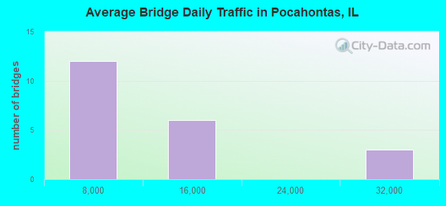
- 168,575Total average daily traffic
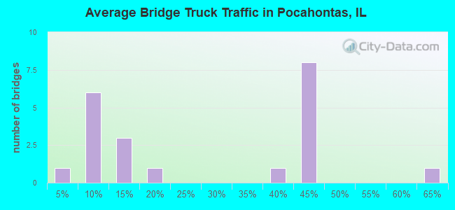
- 64,901Total average daily truck traffic
- National Bridge Inventory (NBI) Registered Bridges for Pocahontas
- No street view available for this location
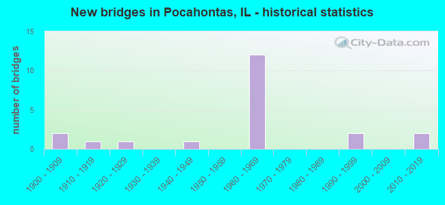
- New bridges - historical statistics
- 21900-1909
- 11910-1919
- 11920-1929
- 11940-1949
- 121960-1969
- 21990-1999
- 22010-2019
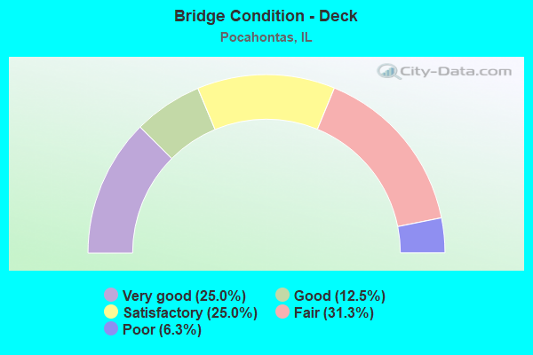
- Bridge Condition - Deck
- 25.0%Very good
- 12.5%Good
- 25.0%Satisfactory
- 31.3%Fair
- 6.3%Poor
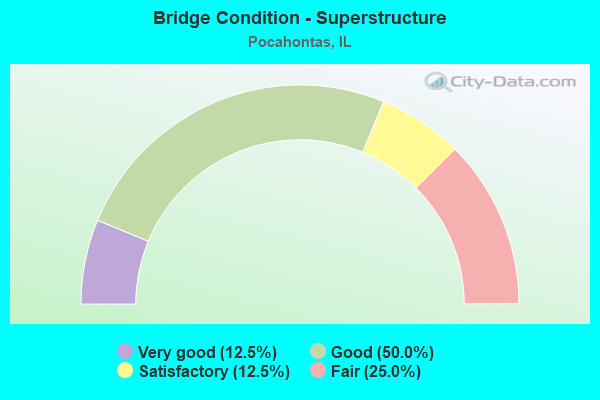
- Bridge Condition - Superstructure
- 12.5%Very good
- 50.0%Good
- 12.5%Satisfactory
- 25.0%Fair
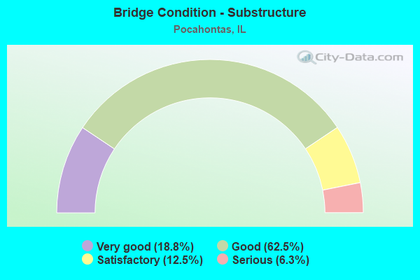
- Bridge Condition - Substructure
- 18.8%Very good
- 62.5%Good
- 12.5%Satisfactory
- 6.3%Serious
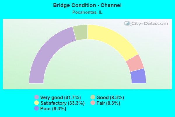
- Bridge Condition - Channel
- 41.7%Very good
- 8.3%Good
- 33.3%Satisfactory
- 8.3%Fair
- 8.3%Poor
Find on map >> Show street view
Structure Number: 30001, Location: 2.1 MI E POCAHONTAS (Lat: 38.834661, Lng: -89.508608), Route carried "on" structure: Interstate 70, Year Built: 1967, Status: Open, Structure Length: 3.63m (11.91ft), Average Daily Traffic: 13,400 (year 2021), Truck Traffic: 41%, Average Future Daily Traffic: 10,836 (year 2032), Design Load: HS 20+Mod, Features Intersected: W BR SHOAL CREEK
Minimum Vertical Clearance: 30+ m (98+ ft), Kilometerpoint: 67.864, Lanes on structure: 2, Base Highway Network: Yes, Owner: State Highway Agency, Approaching Roadway Width: 13.4m (44.0ft), Skew: 2 degrees, Material/Design: Steel continuous, Design/Construction: Stringer/Multi-beam, Number Of Spans In Main Unit: 3, Length of Maximum Span: 12.8m (42.0ft), Curb-To-Curb Width: 12.2m (40.0ft), Out-to-Out Width: 12.8m (42.0ft)
Condition: Deck: Satisfactory, Superstructure: Good, Substructure: Good, Channel: Very good, Operating Rating: 55.1 metric tons, Method Used To Determine Operating Rating: Load Factor (LF) rating reported by rating factor (RF) method using MS18 loading, Inventory Rating: 33.0 metric tons, Method Used To Determine Inventory Rating: Load Factor (LF) rating reported by rating factor (RF) method using MS18 loading, Structural Evaluation: Better than present minimum criteria, Deck Geometry: Better than present minimum criteria, Waterway Adequacy: Superior to present desirable criteria, Approach Roadway Alignment: Equal to present desirable criteria, Designated Inspection Frequency: Every 24 months, Inspection Date: December 2020, Deck Structure Type: Concrete Cast-file-Place, Wearing Surface/Protective System: Wearing Surface: Other
Find on map >> Show street view
Structure Number: 30002, Location: 2.1 MI E POCAHONTAS (Lat: 38.834733, Lng: -89.508444), Route carried "on" structure: Interstate 70, Year Built: 1967, Status: Open, Structure Length: 3.63m (11.91ft), Average Daily Traffic: 13,400 (year 2021), Truck Traffic: 41%, Average Future Daily Traffic: 10,836 (year 2032), Design Load: HS 20+Mod, Features Intersected: W BR SHOAL CREEK
Minimum Vertical Clearance: 30+ m (98+ ft), Kilometerpoint: 67.880, Lanes on structure: 2, Base Highway Network: Yes, Owner: State Highway Agency, Approaching Roadway Width: 13.4m (44.0ft), Skew: 2 degrees, Material/Design: Steel continuous, Design/Construction: Stringer/Multi-beam, Number Of Spans In Main Unit: 3, Length of Maximum Span: 12.8m (42.0ft), Curb-To-Curb Width: 12.2m (40.0ft), Out-to-Out Width: 12.8m (42.0ft)
Condition: Deck: Satisfactory, Superstructure: Good, Substructure: Good, Channel: Very good, Operating Rating: 55.1 metric tons, Method Used To Determine Operating Rating: Load Factor (LF) rating reported by rating factor (RF) method using MS18 loading, Inventory Rating: 33.0 metric tons, Method Used To Determine Inventory Rating: Load Factor (LF) rating reported by rating factor (RF) method using MS18 loading, Structural Evaluation: Better than present minimum criteria, Deck Geometry: Better than present minimum criteria, Waterway Adequacy: Superior to present desirable criteria, Approach Roadway Alignment: Equal to present desirable criteria, Designated Inspection Frequency: Every 24 months, Inspection Date: December 2020, Deck Structure Type: Concrete Cast-file-Place, Wearing Surface/Protective System: Wearing Surface: Other
Find on map >> Show street view
Structure Number: 30003, Location: 2.3 MI E POCAHONTAS (Lat: 38.836103, Lng: -89.505353), Route carried "on" structure: Interstate 70, Year Built: 1967, Status: Open, Structure Length: 12.98m (42.59ft), Average Daily Traffic: 13,400 (year 2021), Truck Traffic: 41%, Average Future Daily Traffic: 10,836 (year 2032), Design Load: HS 20+Mod, Features Intersected: MID FK SHOAL CREEK
Minimum Vertical Clearance: 30+ m (98+ ft), Kilometerpoint: 68.186, Lanes on structure: 2, Base Highway Network: Yes, Owner: State Highway Agency, Approaching Roadway Width: 13.4m (44.0ft), Material/Design: Steel continuous, Design/Construction: Stringer/Multi-beam, Number Of Spans In Main Unit: 4, Length of Maximum Span: 40.5m (132.9ft), Curb-To-Curb Width: 9.9m (32.5ft), Out-to-Out Width: 11.0m (36.1ft)
Condition: Deck: Fair, Superstructure: Fair, Substructure: Good, Channel: Satisfactory, Operating Rating: 47.6 metric tons, Method Used To Determine Operating Rating: Load Factor (LF) rating reported by rating factor (RF) method using MS18 loading, Inventory Rating: 28.5 metric tons, Method Used To Determine Inventory Rating: Load Factor (LF) rating reported by rating factor (RF) method using MS18 loading, Structural Evaluation: Somewhat better than minimum adequacy, Deck Geometry: Meets minimum limits, Waterway Adequacy: Superior to present desirable criteria, Approach Roadway Alignment: Equal to present desirable criteria, Designated Inspection Frequency: Every 24 months, Inspection Date: December 2020, Deck Structure Type: Concrete Cast-file-Place, Wearing Surface/Protective System: Wearing Surface: Other
Find on map >> Show street view
Structure Number: 30004, Location: 2.3 MI E POCAHONTAS (Lat: 38.836169, Lng: -89.505200), Route carried "on" structure: Interstate 70, Year Built: 1967, Status: Open, Structure Length: 12.98m (42.59ft), Average Daily Traffic: 13,400 (year 2021), Truck Traffic: 41%, Average Future Daily Traffic: 10,836 (year 2032), Design Load: HS 20+Mod, Features Intersected: MID FK SHOAL CREEK
Minimum Vertical Clearance: 30+ m (98+ ft), Kilometerpoint: 68.202, Lanes on structure: 2, Base Highway Network: Yes, Owner: State Highway Agency, Approaching Roadway Width: 13.4m (44.0ft), Material/Design: Steel continuous, Design/Construction: Stringer/Multi-beam, Number Of Spans In Main Unit: 4, Length of Maximum Span: 40.5m (132.9ft), Curb-To-Curb Width: 9.9m (32.5ft), Out-to-Out Width: 11.0m (36.1ft)
Condition: Deck: Fair, Superstructure: Fair, Substructure: Good, Channel: Satisfactory, Operating Rating: 47.6 metric tons, Method Used To Determine Operating Rating: Load Factor (LF) rating reported by rating factor (RF) method using MS18 loading, Inventory Rating: 28.5 metric tons, Method Used To Determine Inventory Rating: Load Factor (LF) rating reported by rating factor (RF) method using MS18 loading, Structural Evaluation: Somewhat better than minimum adequacy, Deck Geometry: Meets minimum limits, Waterway Adequacy: Superior to present desirable criteria, Approach Roadway Alignment: Equal to present desirable criteria, Designated Inspection Frequency: Every 24 months, Inspection Date: December 2020, Deck Structure Type: Concrete Cast-file-Place, Wearing Surface/Protective System: Wearing Surface: Other
Find on map >> Show street view
Structure Number: 30005, Location: 2.7 MI E POCAHONTAS (Lat: 38.838628, Lng: -89.499656), Route carried "on" structure: Interstate 70, Year Built: 1967, Status: Open, Structure Length: 7.47m (24.51ft), Average Daily Traffic: 13,400 (year 2021), Truck Traffic: 41%, Average Future Daily Traffic: 10,836 (year 2032), Design Load: HS 20+Mod, Features Intersected: E FORK SHOAL CREEK
Minimum Vertical Clearance: 30+ m (98+ ft), Kilometerpoint: 68.749, Lanes on structure: 2, Base Highway Network: Yes, Owner: State Highway Agency, Approaching Roadway Width: 13.4m (44.0ft), Material/Design: Steel continuous, Design/Construction: Stringer/Multi-beam, Number Of Spans In Main Unit: 4, Length of Maximum Span: 19.8m (65.0ft), Curb-To-Curb Width: 12.2m (40.0ft), Out-to-Out Width: 12.8m (42.0ft)
Condition: Deck: Satisfactory, Superstructure: Good, Substructure: Good, Channel: Satisfactory, Operating Rating: 54.4 metric tons, Method Used To Determine Operating Rating: Load Factor (LF) rating reported by rating factor (RF) method using MS18 loading, Inventory Rating: 32.4 metric tons, Method Used To Determine Inventory Rating: Load Factor (LF) rating reported by rating factor (RF) method using MS18 loading, Structural Evaluation: Better than present minimum criteria, Deck Geometry: Better than present minimum criteria, Waterway Adequacy: Superior to present desirable criteria, Approach Roadway Alignment: Equal to present desirable criteria, Designated Inspection Frequency: Every 24 months, Inspection Date: December 2020, Deck Structure Type: Concrete Cast-file-Place, Wearing Surface/Protective System: Wearing Surface: Other
Find on map >> Show street view
Structure Number: 30006, Location: 2.7 MI E POCAHONTAS (Lat: 38.838700, Lng: -89.499492), Route carried "on" structure: Interstate 70, Year Built: 1967, Status: Open, Structure Length: 7.47m (24.51ft), Average Daily Traffic: 13,400 (year 2021), Truck Traffic: 41%, Average Future Daily Traffic: 10,836 (year 2032), Design Load: HS 20+Mod, Features Intersected: E FORK SHOAL CREEK
Minimum Vertical Clearance: 30+ m (98+ ft), Kilometerpoint: 68.765, Lanes on structure: 2, Base Highway Network: Yes, Owner: State Highway Agency, Approaching Roadway Width: 13.4m (44.0ft), Material/Design: Steel continuous, Design/Construction: Stringer/Multi-beam, Number Of Spans In Main Unit: 4, Length of Maximum Span: 19.8m (65.0ft), Curb-To-Curb Width: 12.2m (40.0ft), Out-to-Out Width: 12.8m (42.0ft)
Condition: Deck: Satisfactory, Superstructure: Good, Substructure: Good, Channel: Satisfactory, Operating Rating: 54.4 metric tons, Method Used To Determine Operating Rating: Load Factor (LF) rating reported by rating factor (RF) method using MS18 loading, Inventory Rating: 32.4 metric tons, Method Used To Determine Inventory Rating: Load Factor (LF) rating reported by rating factor (RF) method using MS18 loading, Structural Evaluation: Better than present minimum criteria, Deck Geometry: Better than present minimum criteria, Waterway Adequacy: Superior to present desirable criteria, Approach Roadway Alignment: Better than present minimum criteria, Designated Inspection Frequency: Every 24 months, Other Special Inspection Frequency: Every 24 months, Inspection Date: December 2020, Other Special Inspection Date: July 2021, Deck Structure Type: Concrete Cast-file-Place, Wearing Surface/Protective System: Wearing Surface: Other
Find on map >> Show street view
Structure Number: 30015, Location: AT POCAHONTAS (Lat: 38.831803, Lng: -89.545586), Route carried "on" structure: County highway , Year Built: 1966, Year Reconstructed: 1999, Status: Open, Structure Length: 7.44m (24.41ft), Average Daily Traffic: 1,300 (year 2020), Truck Traffic: 11%, Average Future Daily Traffic: 1,420 (year 2032), Design Load: HS 20, Features Intersected: FAI 70 EB & WB, Facility Carried by Structure: US 40 / POKEY ROAD
Minimum Vertical Clearance: 30+ m (98+ ft), Kilometerpoint: 6.276, Lanes on structure: 2, Lanes under structure: 4, Owner: State Highway Agency, Approaching Roadway Width: 14.6m (47.9ft), Skew: 32 degrees, Material/Design: Steel continuous, Design/Construction: Stringer/Multi-beam, Number Of Spans In Main Unit: 4, Length of Maximum Span: 22.3m (73.2ft), Curb-To-Curb Width: 11.4m (37.4ft), Out-to-Out Width: 17.7m (58.1ft)
Condition: Deck: Poor, Superstructure: Satisfactory, Substructure: Good, Operating Rating: 59.6 metric tons, Method Used To Determine Operating Rating: Load Factor (LF) rating reported by rating factor (RF) method using MS18 loading, Inventory Rating: 36.0 metric tons, Method Used To Determine Inventory Rating: Load Factor (LF) rating reported by rating factor (RF) method using MS18 loading, Structural Evaluation: Equal to present minimum criteria, Deck Geometry: Equal to present minimum criteria, Underclear: Meets minimum limits, Approach Roadway Alignment: Equal to present desirable criteria, Designated Inspection Frequency: Every 24 months, Inspection Date: Febuary 2021, Deck Structure Type: Concrete Cast-file-Place, Wearing Surface/Protective System: Wearing Surface: Other
Find on map >> Show street view
Structure Number: 30016, Location: 1.6 MI E POCAHONTAS (Lat: 38.832550, Lng: -89.516092), Route carried "on" structure: US 40, Year Built: 1966, Year Reconstructed: 2001, Status: Open, Structure Length: 8.75m (28.71ft), Average Daily Traffic: 1,100 (year 2021), Truck Traffic: 7%, Average Future Daily Traffic: 1,262 (year 2032), Design Load: HS 20, Features Intersected: FAI 70 EB & WB
Minimum Vertical Clearance: 30+ m (98+ ft), Kilometerpoint: 66.657, Lanes on structure: 2, Lanes under structure: 4, Owner: State Highway Agency, Approaching Roadway Width: 12.8m (42.0ft), Skew: 3 degrees, Material/Design: Steel continuous, Design/Construction: Stringer/Multi-beam, Number Of Spans In Main Unit: 4, Length of Maximum Span: 26.2m (86.0ft), Curb-To-Curb Width: 10.1m (33.1ft), Out-to-Out Width: 10.7m (35.1ft)
Condition: Deck: Good, Superstructure: Good, Substructure: Good, Operating Rating: 72.3 metric tons, Method Used To Determine Operating Rating: Load Factor (LF) rating reported by rating factor (RF) method using MS18 loading, Inventory Rating: 43.1 metric tons, Method Used To Determine Inventory Rating: Load Factor (LF) rating reported by rating factor (RF) method using MS18 loading, Structural Evaluation: Better than present minimum criteria, Deck Geometry: Somewhat better than minimum adequacy, Underclear: Meets minimum limits, Approach Roadway Alignment: Equal to present minimum criteria, Designated Inspection Frequency: Every 24 months, Inspection Date: December 2020, Deck Structure Type: Concrete Cast-file-Place, Wearing Surface/Protective System: Deck Protection: Epoxy Coated Reinforcing
Find on map >> Show street view
Structure Number: 30038, Location: 0.1 MI W POCAHONTAS (Lat: 38.824317, Lng: -89.548950), Route carried "on" structure: County highway , Year Built: 1912, Status: Posted for load, Structure Length: 1.07m (3.51ft), Average Daily Traffic: 600 (year 2020), Truck Traffic: 8%, Average Future Daily Traffic: 526 (year 2032), Features Intersected: E Trib to Shoal Crk, Facility Carried by Structure: State Street SBI 1
Minimum Vertical Clearance: 30+ m (98+ ft), Kilometerpoint: 1.336, Lanes on structure: 2, Owner: State Highway Agency, Approaching Roadway Width: 9.1m (29.9ft), Skew: 4 degrees, Material/Design: Concrete, Number Of Spans In Main Unit: 1, Length of Maximum Span: 9.4m (30.8ft), Curb-To-Curb Width: 5.9m (19.4ft), Out-to-Out Width: 7.1m (23.3ft)
Condition: Deck: Fair, Superstructure: Fair, Substructure: Satisfactory, Channel: Fair, Operating Rating: 33.7 metric tons, Method Used To Determine Operating Rating: Load Factor (LF) rating reported by rating factor (RF) method using MS18 loading, Inventory Rating: 20.4 metric tons, Method Used To Determine Inventory Rating: Load Factor (LF) rating reported by rating factor (RF) method using MS18 loading, Structural Evaluation: Somewhat better than minimum adequacy, Deck Geometry: High priority of replacement, Waterway Adequacy: Equal to present desirable criteria, Approach Roadway Alignment: Equal to present minimum criteria, Bridge Posting: Required (Relationship of Operating Rating to Maximum Legal Load: > 39.9% below), Length Of Structure Improvement: 1.07m (3.51ft), Designated Inspection Frequency: Every 12 months, Inspection Date: Febuary 2022, Bridge Improvement Cost: $41,000, Roadway Improvement Cost: $4,000, Total Project Cost: $45,000, Deck Structure Type: Concrete Cast-file-Place, Wearing Surface/Protective System: Wearing Surface: Bituminous
Find on map >> Show street view
Structure Number: 30043, Location: 3.2 MI E POCAHONTAS (Lat: 38.842239, Lng: -89.491519), Route carried "on" structure: County highway , Year Built: 1966, Year Reconstructed: 2001, Status: Open, Structure Length: 6.84m (22.44ft), Average Daily Traffic: 125 (year 2020), Truck Traffic: 18%, Average Future Daily Traffic: 210 (year 2032), Design Load: HS 15, Features Intersected: FAI 70, Facility Carried by Structure: TR 112-SUGARLOAF R
Minimum Vertical Clearance: 30+ m (98+ ft), Kilometerpoint: 0.032, Lanes on structure: 2, Lanes under structure: 4, Owner: State Highway Agency, Approaching Roadway Width: 8.5m (27.9ft), Material/Design: Steel continuous, Design/Construction: Stringer/Multi-beam, Number Of Spans In Main Unit: 4, Length of Maximum Span: 20.5m (67.3ft), Curb-To-Curb Width: 8.1m (26.6ft), Out-to-Out Width: 9.1m (29.9ft)
Condition: Deck: Very good, Superstructure: Good, Substructure: Good, Operating Rating: 55.7 metric tons, Method Used To Determine Operating Rating: Load Factor (LF) rating reported by rating factor (RF) method using MS18 loading, Inventory Rating: 32.1 metric tons, Method Used To Determine Inventory Rating: Load Factor (LF) rating reported by rating factor (RF) method using MS18 loading, Structural Evaluation: Better than present minimum criteria, Deck Geometry: Somewhat better than minimum adequacy, Underclear: Meets minimum limits, Approach Roadway Alignment: Equal to present desirable criteria, Designated Inspection Frequency: Every 24 months, Inspection Date: December 2020, Deck Structure Type: Concrete Cast-file-Place, Wearing Surface/Protective System: Deck Protection: Epoxy Coated Reinforcing
Find on map >> Show street view
Structure Number: 30058, Location: 1.9 MI E POCAHONTAS (Lat: 38.836556, Lng: -89.505839), Route carried "on" structure: US 40, Year Built: 1994, Status: Open, Structure Length: 13.41m (44.00ft), Average Daily Traffic: 1,100 (year 2021), Truck Traffic: 7%, Average Future Daily Traffic: 1,262 (year 2032), Design Load: HS 20, Features Intersected: SHOAL CREEK
Minimum Vertical Clearance: 30+ m (98+ ft), Kilometerpoint: 67.703, Lanes on structure: 2, Owner: State Highway Agency, Approaching Roadway Width: 8.5m (27.9ft), Skew: 3 degrees, Material/Design: Steel continuous, Design/Construction: Stringer/Multi-beam, Number Of Spans In Main Unit: 4, Length of Maximum Span: 39.6m (129.9ft), Curb-To-Curb Width: 9.8m (32.2ft), Out-to-Out Width: 10.7m (35.1ft)
Condition: Deck: Very good, Superstructure: Good, Substructure: Very good, Channel: Very good, Operating Rating: 63.8 metric tons, Method Used To Determine Operating Rating: Load Factor (LF) rating reported by rating factor (RF) method using MS18 loading, Inventory Rating: 38.2 metric tons, Method Used To Determine Inventory Rating: Load Factor (LF) rating reported by rating factor (RF) method using MS18 loading, Structural Evaluation: Better than present minimum criteria, Deck Geometry: Somewhat better than minimum adequacy, Waterway Adequacy: Superior to present desirable criteria, Approach Roadway Alignment: Equal to present desirable criteria, Designated Inspection Frequency: Every 24 months, Inspection Date: Febuary 2021, Deck Structure Type: Concrete Cast-file-Place, Wearing Surface/Protective System: Deck Protection: Epoxy Coated Reinforcing
Find on map >> Show street view
Structure Number: 30059, Location: 1.9 MI E POCAHONTAS (Lat: 38.839269, Lng: -89.499803), Route carried "on" structure: US 40, Year Built: 1993, Status: Open, Structure Length: 7.61m (24.97ft), Average Daily Traffic: 1,100 (year 2021), Truck Traffic: 7%, Average Future Daily Traffic: 1,262 (year 2032), Design Load: HS 20, Features Intersected: E Fork SHOAL CREEK
Minimum Vertical Clearance: 30+ m (98+ ft), Kilometerpoint: 68.315, Lanes on structure: 2, Owner: State Highway Agency, Approaching Roadway Width: 7.3m (24.0ft), Material/Design: Prestressed concrete, Design/Construction: Stringer/Multi-beam, Number Of Spans In Main Unit: 2, Length of Maximum Span: 38.1m (125.0ft), Curb-To-Curb Width: 9.8m (32.2ft), Out-to-Out Width: 10.7m (35.1ft)
Condition: Deck: Fair, Superstructure: Good, Substructure: Good, Channel: Very good, Operating Rating: 74.2 metric tons, Method Used To Determine Operating Rating: Load Factor (LF) rating reported by rating factor (RF) method using MS18 loading, Inventory Rating: 44.4 metric tons, Method Used To Determine Inventory Rating: Load Factor (LF) rating reported by rating factor (RF) method using MS18 loading, Structural Evaluation: Better than present minimum criteria, Deck Geometry: Somewhat better than minimum adequacy, Waterway Adequacy: Superior to present desirable criteria, Approach Roadway Alignment: Equal to present desirable criteria, Designated Inspection Frequency: Every 24 months, Inspection Date: Febuary 2021, Deck Structure Type: Concrete Cast-file-Place, Wearing Surface/Protective System: Deck Protection: Epoxy Coated Reinforcing
Find on map >> Show street view
Structure Number: 30063, Location: 1.7 MI E Pocahontas (Lat: 38.835281, Lng: -89.508644), Route carried "on" structure: US 40, Year Built: 2017, Status: Open, Structure Length: 3.29m (10.79ft), Average Daily Traffic: 1,100 (year 2021), Truck Traffic: 7%, Average Future Daily Traffic: 1,262 (year 2032), Design Load: HS 25 or greater, Features Intersected: W Fork Shoal Creek
Minimum Vertical Clearance: 30+ m (98+ ft), Kilometerpoint: 67.430, Lanes on structure: 2, Owner: State Highway Agency, Approaching Roadway Width: 9.8m (32.2ft), Material/Design: Steel, Design/Construction: Stringer/Multi-beam, Number Of Spans In Main Unit: 1, Length of Maximum Span: 31.8m (104.3ft), Curb-To-Curb Width: 9.8m (32.2ft), Out-to-Out Width: 10.7m (35.1ft)
Condition: Deck: Very good, Superstructure: Very good, Substructure: Very good, Channel: Good, Operating Rating: 71.0 metric tons, Method Used To Determine Operating Rating: Load and Resistance Factor Rating (LRFR) rating reported by rating factor(RF) method using HL-93 loadings, Inventory Rating: 54.4 metric tons, Method Used To Determine Inventory Rating: Load and Resistance Factor Rating (LRFR) rating reported by rating factor(RF) method using HL-93 loadings, Structural Evaluation: Equal to present desirable criteria, Deck Geometry: Somewhat better than minimum adequacy, Waterway Adequacy: Superior to present desirable criteria, Approach Roadway Alignment: Equal to present desirable criteria, Designated Inspection Frequency: Every 24 months, Inspection Date: Febuary 2021, Deck Structure Type: Concrete Cast-file-Place, Wearing Surface/Protective System: Deck Protection: Epoxy Coated Reinforcing
Find on map >> Show street view
Structure Number: 33053, Location: 1.5 Mi N Pocahontas (Lat: 38.849697, Lng: -89.547711), Route carried "on" structure: County highway , Year Built: 2013, Status: Open, Structure Length: 3.66m (12.01ft), Average Daily Traffic: 1,300 (year 2020), Truck Traffic: 11%, Average Future Daily Traffic: 1,800 (year 2032), Design Load: HS 25 or greater, Features Intersected: Trib. to Shoal Ck, Facility Carried by Structure: FAS779 Pokey Rd CH
Minimum Vertical Clearance: 30+ m (98+ ft), Kilometerpoint: 4.281, Lanes on structure: 2, Owner: County Highway Agency, Approaching Roadway Width: 10.4m (34.1ft), Material/Design: Prestressed concrete, Design/Construction: Box Beam or Girders - Multiple, Number Of Spans In Main Unit: 3, Length of Maximum Span: 12.2m (40.0ft), Curb-To-Curb Width: 11.0m (36.1ft), Out-to-Out Width: 11.0m (36.1ft)
Condition: Deck: Very good, Superstructure: Very good, Substructure: Very good, Channel: Very good, Operating Rating: 42.1 metric tons, Method Used To Determine Operating Rating: Assigned ratings based on Load and Resistance Factor Design (LRFD) reported by rating factor (RF) using HL93 loadings, Inventory Rating: 32.4 metric tons, Method Used To Determine Inventory Rating: Assigned ratings based on Load and Resistance Factor Design (LRFD) reported by rating factor (RF) using HL93 loadings, Structural Evaluation: Equal to present desirable criteria, Deck Geometry: Equal to present minimum criteria, Waterway Adequacy: Superior to present desirable criteria, Approach Roadway Alignment: Equal to present desirable criteria, Designated Inspection Frequency: Every 48 months, Inspection Date: December 2021, Deck Structure Type: Concrete Precast Panels, Wearing Surface/Protective System: Wearing Surface: Bituminous, Membrane: Built-up, Deck Protection: Epoxy Coated Reinforcing
Find on map >> Show street view
Structure Number: 341, Location: POCAHONTAS (Lat: 38.826272, Lng: -89.548075), Route carried "on" structure: City street , Year Built: 1920, Status: Open, Structure Length: 0.69m (2.26ft), Average Daily Traffic: 50 (year 2020), Truck Traffic: 60%, Average Future Daily Traffic: 237 (year 2032), Features Intersected: TRIB OF SHOAL CK, Facility Carried by Structure: RUSSEL ST MSS 1034
Minimum Vertical Clearance: 30+ m (98+ ft), Kilometerpoint: 0.177, Lanes on structure: 1, Owner: City or Municipal Highway Agency, Approaching Roadway Width: 4.9m (16.1ft), Material/Design: Steel, Design/Construction: Stringer/Multi-beam, Number Of Spans In Main Unit: 1, Length of Maximum Span: 6.9m (22.6ft), Curb-To-Curb Width: 3.9m (12.8ft), Out-to-Out Width: 4.9m (16.1ft)
Condition: Deck: Good, Superstructure: Satisfactory, Substructure: Serious, Channel: Poor, Operating Rating: 45.0 metric tons, Method Used To Determine Operating Rating: Load Factor (LF) rating reported by rating factor (RF) method using MS18 loading, Inventory Rating: 26.9 metric tons, Method Used To Determine Inventory Rating: Load Factor (LF) rating reported by rating factor (RF) method using MS18 loading, Structural Evaluation: High priority of corrective action, Deck Geometry: Meets minimum limits, Waterway Adequacy: Equal to present minimum criteria, Approach Roadway Alignment: Equal to present minimum criteria, Length Of Structure Improvement: 0.70m (2.30ft), Designated Inspection Frequency: Every 24 months, Inspection Date: December 2021, Bridge Improvement Cost: $28,000, Roadway Improvement Cost: $3,000, Total Project Cost: $31,000, Deck Structure Type: Wood or Timber, Wearing Surface/Protective System: Wearing Surface: Wood or Timber
Find on map >> Show street view
Structure Number: 39906, Location: 0.35 M S OF STATE ST (Lat: 38.823139, Lng: -89.535906), Route carried "on" structure: City street , Year Built: 1901, Status: Open, Structure Length: 4.02m (13.19ft), Average Daily Traffic: 200 (year 2020), Truck Traffic: 2%, Average Future Daily Traffic: 158 (year 2032), Features Intersected: CONRAIL RR, Facility Carried by Structure: MSS 6130
Minimum Vertical Clearance: 30+ m (98+ ft), Kilometerpoint: 0.628, Lanes on structure: 2, Owner: Railroad, Approaching Roadway Width: 7.9m (25.9ft), Material/Design: Concrete, Design/Construction: Tee Beam, Number Of Spans In Main Unit: 3, Length of Maximum Span: 16.2m (53.1ft), Curb or Sidewalk Widths: Left: 0.6m (2.0ft), Right: 1.2m (3.9ft), Curb-To-Curb Width: 7.3m (24.0ft), Out-to-Out Width: 9.9m (32.5ft)
Condition: Deck: Fair, Superstructure: Fair, Substructure: Satisfactory, Operating Rating: 40.5 metric tons, Method Used To Determine Operating Rating: Field evaluation and documented engineering judgment, Inventory Rating: 24.3 metric tons, Method Used To Determine Inventory Rating: Field evaluation and documented engineering judgment, Structural Evaluation: Somewhat better than minimum adequacy, Deck Geometry: Somewhat better than minimum adequacy, Underclear: High priority of replacement, Approach Roadway Alignment: Meets minimum limits, Length Of Structure Improvement: 4.02m (13.19ft), Designated Inspection Frequency: Every 24 months, Inspection Date: December 2021, Bridge Improvement Cost: $205,000, Roadway Improvement Cost: $21,000, Total Project Cost: $226,000
Find on map >> Show street view
Structure Number: 30015, Location: AT POCAHONTAS (Lat: 38.831539, Lng: -89.545569), Route carried "under" structure: Interstate 70, Year Built: 1966, Structure Length: 0. m, Average Daily Traffic: 25,500 (year 2021), Truck Traffic: 36%, Features Intersected: FAI 70 EB & WB, Facility Carried by Structure: US 40 / POKEY ROAD
Minimum Vertical Clearance: 5.56m (18.24ft), Kilometerpoint: 64.501, Lanes on structure: 2, Lanes under structure: 4, Material/Design: Steel continuous, Design/Construction: Stringer/Multi-beam, Length of Maximum Span: 22.3m (73.2ft)
Find on map >> Show street view
Structure Number: 30016, Location: 1.6 MI E POCAHONTAS (Lat: 38.832550, Lng: -89.516092), Route carried "under" structure: Interstate 70, Year Built: 1966, Structure Length: 0. m, Average Daily Traffic: 26,800 (year 2021), Truck Traffic: 41%, Features Intersected: FAI 70 EB & WB, Facility Carried by Structure: US 40/FAS 779
Minimum Vertical Clearance: 5.72m (18.77ft), Kilometerpoint: 67.172, Lanes on structure: 2, Lanes under structure: 4, Material/Design: Steel continuous, Design/Construction: Stringer/Multi-beam, Length of Maximum Span: 26.2m (86.0ft)
Find on map >> Show street view
Structure Number: 30043, Location: 3.2 MI E POCAHONTAS (Lat: 38.842239, Lng: -89.491519), Route carried "under" structure: Interstate 70, Year Built: 1966, Structure Length: 0. m, Average Daily Traffic: 26,800 (year 2021), Truck Traffic: 41%, Features Intersected: FAI 70, Facility Carried by Structure: TR 112-SUGARLOAF R
Minimum Vertical Clearance: 5.31m (17.42ft), Kilometerpoint: 69.554, Lanes on structure: 2, Lanes under structure: 4, Material/Design: Steel continuous, Design/Construction: Stringer/Multi-beam, Length of Maximum Span: 20.5m (67.3ft)
Find on map >> Show street view
Structure Number: 399, Location: 1.09M S US 40 (Lat: 38.821583, Lng: -89.540508), Route carried "under" structure: County highway , Year Built: 1943, Structure Length: 0. m, Average Daily Traffic: 1,000 (year 2020), Truck Traffic: 7%, Features Intersected: FAS 781/ACADEMY ST, Facility Carried by Structure: CONSL RR
Minimum Vertical Clearance: 4.24m (13.91ft), Kilometerpoint: 0.869, Lanes under structure: 2, Material/Design: Steel, Design/Construction: Stringer/Multi-beam, Length of Maximum Span: 11.0m (36.1ft)
Find on map >> Show street view
Structure Number: 39903, Location: 2.75 M NE POCAHONTAS (Lat: 38.838028, Lng: -89.490561), Route carried "under" structure: County highway , Year Built: 1900, Structure Length: 0. m, Average Daily Traffic: 100 (year 2020), Truck Traffic: 13%, Features Intersected: TR 112, Facility Carried by Structure: CONRAIL RR
Minimum Vertical Clearance: 4.01m (13.16ft), Kilometerpoint: 0.628, Lanes under structure: 2, Material/Design: Steel, Design/Construction: Girder and Floorbeam System, Length of Maximum Span: 9.8m (32.2ft)