Bridge Statistics for Quitman, Texas (TX)
Condition, Traffic, Stress, Structural Evaluation, Project Costs
- National Bridge Inventory (NBI) Statistics
- 14Number of bridges
- 210ft / 64.4mTotal length
- $929,000Total costs
- 27,819Total average daily traffic
- 2,165Total average daily truck traffic
- 34,505Total future (year 2029) average daily traffic
- National Bridge Inventory (NBI) Registered Bridges for Quitman
- No street view available for this location
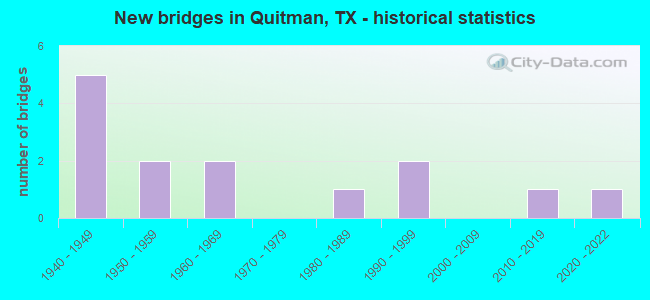
- New bridges - historical statistics
- 51940-1949
- 21950-1959
- 21960-1969
- 11980-1989
- 21990-1999
- 12010-2019
- 12020-2022

- Reconstructed bridges - Historical Statistics
- 11970-1979
- 01980-1989
- 01990-1999
- 12000-2009


- Bridge Condition - Deck
- 16.7%Very good
- 66.7%Good
- 16.7%Satisfactory

- Bridge Condition - Superstructure
- 16.7%Very good
- 66.7%Good
- 16.7%Satisfactory

- Bridge Condition - Substructure
- 16.7%Very good
- 33.3%Good
- 50.0%Satisfactory

- Bridge Condition - Channel
- 28.6%Good
- 71.4%Satisfactory

- Bridge Condition - Culverts
- 37.5%Good
- 50.0%Satisfactory
- 12.5%Fair
Find on map >> Show street view
Structure Number: 102500019002038, Location: 1.65 MI N OF SH 154 (Lat: 32.817331, Lng: -95.434311), Route carried "on" structure: State highway 37, Year Built: 1949, Year Reconstructed: 1970, Status: Open, Structure Length: 1.98m (6.50ft), Average Daily Traffic: 4,362 (year 2020), Truck Traffic: 13%, Average Future Daily Traffic: 6,070 (year 2033), Design Load: HS 20, Features Intersected: LITTLE DRY CREEK
Minimum Vertical Clearance: 30+ m (98+ ft), Kilometerpoint: 24.409, Lanes on structure: 2, Owner: State Highway Agency, Approaching Roadway Width: 13.4m (44.0ft), Skew: 4 degrees, Material/Design: Concrete, Design/Construction: Culvert, Number Of Spans In Main Unit: 4, Length of Maximum Span: 3.0m (9.8ft)
Condition: Channel: Satisfactory, Culverts: Satisfactory, Operating Rating: 39.9 metric tons, Method Used To Determine Operating Rating: Load Factor (LF), Inventory Rating: 23.6 metric tons, Method Used To Determine Inventory Rating: Load Factor (LF), Structural Evaluation: Equal to present minimum criteria, Waterway Adequacy: Equal to present minimum criteria, Approach Roadway Alignment: Equal to present desirable criteria, Designated Inspection Frequency: Every 24 months, Inspection Date: September 2020
Find on map >> Show street view
Structure Number: 102500019003037, Location: 2.40 MI S OF SH 154 (Lat: 32.761422, Lng: -95.464564), Route carried "on" structure: State highway 37, Year Built: 1967, Status: Open, Structure Length: 24.38m (79.99ft), Average Daily Traffic: 9,435 (year 2020), Truck Traffic: 6%, Average Future Daily Traffic: 11,450 (year 2033), Design Load: H 20, Features Intersected: LAKE FORK CREEK
Minimum Vertical Clearance: 30+ m (98+ ft), Kilometerpoint: 6.949, Lanes on structure: 2, Owner: State Highway Agency, Approaching Roadway Width: 11.0m (36.1ft), Material/Design: Concrete, Design/Construction: Stringer/Multi-beam, Number Of Spans In Main Unit: 20, Length of Maximum Span: 12.2m (40.0ft), Curb-To-Curb Width: 10.7m (35.1ft), Out-to-Out Width: 11.3m (37.1ft)
Condition: Deck: Satisfactory, Superstructure: Satisfactory, Substructure: Satisfactory, Channel: Satisfactory, Operating Rating: 53.5 metric tons, Method Used To Determine Operating Rating: Load Factor (LF), Inventory Rating: 31.7 metric tons, Method Used To Determine Inventory Rating: Load Factor (LF), Structural Evaluation: Equal to present minimum criteria, Deck Geometry: Meets minimum limits, Waterway Adequacy: Equal to present minimum criteria, Approach Roadway Alignment: Equal to present desirable criteria, Length Of Structure Improvement: 24.38m (79.99ft), Designated Inspection Frequency: Every 24 months, Inspection Date: September 2020, Bridge Improvement Cost: $600,000, Roadway Improvement Cost: $160,000, Total Project Cost: $760,000, Deck Structure Type: Concrete Cast-file-Place
Find on map >> Show street view
Structure Number: 102500040102015, Location: 0.75 MI W OF SH 37 (Lat: 32.798050, Lng: -95.464381), Route carried "on" structure: State highway 154, Year Built: 2013, Status: Open, Structure Length: 16.79m (55.09ft), Average Daily Traffic: 6,030 (year 2020), Truck Traffic: 7%, Average Future Daily Traffic: 7,280 (year 2033), Design Load: HL 93, Features Intersected: DRY CREEK
Minimum Vertical Clearance: 30+ m (98+ ft), Kilometerpoint: 23.471, Lanes on structure: 2, Owner: State Highway Agency, Approaching Roadway Width: 14.0m (45.9ft), Material/Design: Prestressed concrete, Design/Construction: Stringer/Multi-beam, Number Of Spans In Main Unit: 9, Length of Maximum Span: 21.6m (70.9ft), Curb-To-Curb Width: 14.0m (45.9ft), Out-to-Out Width: 14.6m (47.9ft)
Condition: Deck: Good, Superstructure: Good, Substructure: Very good, Channel: Good, Operating Rating: 54.4 metric tons, Method Used To Determine Operating Rating: Assigned ratings based on Load and Resistance Factor Design (LRFD) reported in metric tons, Inventory Rating: 32.7 metric tons, Method Used To Determine Inventory Rating: Assigned ratings based on Load and Resistance Factor Design (LRFD) reported in metric tons, Structural Evaluation: Better than present minimum criteria, Deck Geometry: Superior to present desirable criteria, Waterway Adequacy: Equal to present minimum criteria, Approach Roadway Alignment: Equal to present desirable criteria, Designated Inspection Frequency: Every 24 months, Inspection Date: September 2020, Deck Structure Type: Concrete Precast Panels
Find on map >> Show street view
Structure Number: 102500042901014, Location: 1.65 MI W 0F SH 154 (Lat: 32.810075, Lng: -95.501053), Route carried "on" structure: State highway 182, Year Built: 1951, Status: Open, Structure Length: 0.82m (2.69ft), Average Daily Traffic: 971 (year 2020), Average Future Daily Traffic: 1,610 (year 2031), Features Intersected: GEORGE SLOUGH
Minimum Vertical Clearance: 30+ m (98+ ft), Kilometerpoint: 15.764, Lanes on structure: 2, Owner: State Highway Agency, Approaching Roadway Width: 6.7m (22.0ft), Material/Design: Concrete, Design/Construction: Culvert, Number Of Spans In Main Unit: 3, Length of Maximum Span: 2.4m (7.9ft), Curb-To-Curb Width: 12.8m (42.0ft), Out-to-Out Width: 13.2m (43.3ft)
Condition: Channel: Satisfactory, Culverts: Satisfactory, Operating Rating: 32.7 metric tons, Method Used To Determine Operating Rating: Field evaluation and documented engineering judgment, Inventory Rating: 24.5 metric tons, Method Used To Determine Inventory Rating: Field evaluation and documented engineering judgment, Structural Evaluation: Equal to present minimum criteria, Deck Geometry: Superior to present desirable criteria, Waterway Adequacy: Equal to present minimum criteria, Approach Roadway Alignment: Equal to present desirable criteria, Length Of Structure Improvement: 0.82m (2.69ft), Designated Inspection Frequency: Every 24 months, Inspection Date: September 2020, Bridge Improvement Cost: $1,000, Total Project Cost: $1,000, Deck Structure Type: Concrete Cast-file-Place, Wearing Surface/Protective System: Wearing Surface: Bituminous
Find on map >> Show street view
Structure Number: 102500042902009, Location: 2.70 MI SE OF SH 37 (Lat: 32.763939, Lng: -95.421167), Route carried "on" structure: State highway 778, Year Built: 1949, Year Reconstructed: 2011, Status: Open, Structure Length: 1.62m (5.31ft), Average Daily Traffic: 900 (year 2020), Truck Traffic: 11%, Average Future Daily Traffic: 1,140 (year 2033), Design Load: H 15, Features Intersected: GLADE CREEK
Minimum Vertical Clearance: 30+ m (98+ ft), Kilometerpoint: 4.352, Lanes on structure: 2, Owner: State Highway Agency, Approaching Roadway Width: 7.6m (24.9ft), Material/Design: Concrete, Design/Construction: Culvert, Number Of Spans In Main Unit: 8, Length of Maximum Span: 1.8m (5.9ft), Curb-To-Curb Width: 2.4m (7.9ft), Out-to-Out Width: 12.0m (39.4ft)
Condition: Channel: Good, Culverts: Satisfactory, Operating Rating: 39.9 metric tons, Method Used To Determine Operating Rating: Load Factor (LF), Inventory Rating: 23.6 metric tons, Method Used To Determine Inventory Rating: Load Factor (LF), Structural Evaluation: Equal to present minimum criteria, Deck Geometry: High priority of replacement, Waterway Adequacy: Equal to present minimum criteria, Approach Roadway Alignment: Better than present minimum criteria, Length Of Structure Improvement: 1.62m (5.31ft), Designated Inspection Frequency: Every 24 months, Inspection Date: September 2020, Deck Structure Type: Concrete Cast-file-Place, Wearing Surface/Protective System: Wearing Surface: Bituminous
Find on map >> Show street view
Structure Number: 102500076603017, Location: 1.65 MI N OF SH 37 (Lat: 32.857058, Lng: -95.424214), Route carried "on" structure: State highway 69, Year Built: 1948, Status: Open, Structure Length: 0.79m (2.59ft), Average Daily Traffic: 857 (year 2020), Truck Traffic: 9%, Average Future Daily Traffic: 1,110 (year 2033), Features Intersected: CARTER CREEK
Minimum Vertical Clearance: 30+ m (98+ ft), Kilometerpoint: 7.932, Lanes on structure: 2, Owner: State Highway Agency, Approaching Roadway Width: 7.3m (24.0ft), Material/Design: Concrete, Design/Construction: Culvert, Number Of Spans In Main Unit: 4, Length of Maximum Span: 1.8m (5.9ft), Curb-To-Curb Width: 17.1m (56.1ft), Out-to-Out Width: 17.7m (58.1ft)
Condition: Channel: Satisfactory, Culverts: Good, Operating Rating: 32.7 metric tons, Method Used To Determine Operating Rating: Field evaluation and documented engineering judgment, Inventory Rating: 24.5 metric tons, Method Used To Determine Inventory Rating: Field evaluation and documented engineering judgment, Structural Evaluation: Equal to present minimum criteria, Deck Geometry: Superior to present desirable criteria, Waterway Adequacy: Equal to present minimum criteria, Approach Roadway Alignment: Equal to present desirable criteria, Designated Inspection Frequency: Every 24 months, Inspection Date: September 2020, Deck Structure Type: Concrete Cast-file-Place, Wearing Surface/Protective System: Wearing Surface: Bituminous
Find on map >> Show street view
Structure Number: 102500076603018, Location: 1.3 MI N OF SH 37 (Lat: 32.851853, Lng: -95.426436), Route carried "on" structure: State highway 69, Year Built: 1948, Status: Open, Structure Length: 1.19m (3.90ft), Average Daily Traffic: 857 (year 2020), Truck Traffic: 9%, Average Future Daily Traffic: 1,110 (year 2033), Features Intersected: MUDDY CREEK
Minimum Vertical Clearance: 30+ m (98+ ft), Kilometerpoint: 8.542, Lanes on structure: 2, Owner: State Highway Agency, Approaching Roadway Width: 7.3m (24.0ft), Material/Design: Concrete, Design/Construction: Culvert, Number Of Spans In Main Unit: 6, Length of Maximum Span: 1.8m (5.9ft), Curb-To-Curb Width: 17.4m (57.1ft), Out-to-Out Width: 17.7m (58.1ft)
Condition: Channel: Satisfactory, Culverts: Good, Operating Rating: 32.7 metric tons, Method Used To Determine Operating Rating: Field evaluation and documented engineering judgment, Inventory Rating: 24.5 metric tons, Method Used To Determine Inventory Rating: Field evaluation and documented engineering judgment, Structural Evaluation: Equal to present minimum criteria, Deck Geometry: Superior to present desirable criteria, Waterway Adequacy: Equal to present minimum criteria, Approach Roadway Alignment: Equal to present desirable criteria, Designated Inspection Frequency: Every 24 months, Inspection Date: September 2020, Deck Structure Type: Concrete Cast-file-Place, Wearing Surface/Protective System: Wearing Surface: Bituminous
Find on map >> Show street view
Structure Number: 102500111101002, Location: 0.5 MI W OF SH 37 (Lat: 32.758639, Lng: -95.475914), Route carried "on" structure: State highway 779, Year Built: 1949, Status: Open, Structure Length: 1.22m (4.00ft), Average Daily Traffic: 1,014 (year 2020), Truck Traffic: 9%, Average Future Daily Traffic: 1,300 (year 2033), Features Intersected: TURMAN BRANCH
Minimum Vertical Clearance: 30+ m (98+ ft), Kilometerpoint: 10.235, Lanes on structure: 2, Owner: State Highway Agency, Approaching Roadway Width: 6.7m (22.0ft), Material/Design: Concrete, Design/Construction: Culvert, Number Of Spans In Main Unit: 6, Length of Maximum Span: 1.8m (5.9ft)
Condition: Channel: Satisfactory, Culverts: Good, Operating Rating: 32.7 metric tons, Method Used To Determine Operating Rating: Field evaluation and documented engineering judgment, Inventory Rating: 24.5 metric tons, Method Used To Determine Inventory Rating: Field evaluation and documented engineering judgment, Structural Evaluation: Equal to present minimum criteria, Waterway Adequacy: Equal to present minimum criteria, Approach Roadway Alignment: Equal to present desirable criteria, Designated Inspection Frequency: Every 24 months, Inspection Date: September 2020
Find on map >> Show street view
Structure Number: 102500139003006, Location: 1.15 MI W OF FM 778 (Lat: 32.743528, Lng: -95.417725), Route carried "on" structure: State highway 1254, Year Built: 1951, Status: Open, Structure Length: 0.70m (2.30ft), Average Daily Traffic: 722 (year 2018), Truck Traffic: 17%, Average Future Daily Traffic: 460 (year 2033), Features Intersected: EDMOORE CREEK
Minimum Vertical Clearance: 6.30m (20.67ft), Kilometerpoint: 11.405, Lanes on structure: 2, Owner: State Highway Agency, Approaching Roadway Width: 7.6m (24.9ft), Material/Design: Concrete, Design/Construction: Culvert, Number Of Spans In Main Unit: 4, Length of Maximum Span: 1.5m (4.9ft), Curb-To-Curb Width: 9.8m (32.2ft), Out-to-Out Width: 10.3m (33.8ft)
Condition: Channel: Satisfactory, Culverts: Fair, Operating Rating: 32.7 metric tons, Method Used To Determine Operating Rating: Field evaluation and documented engineering judgment, Inventory Rating: 24.5 metric tons, Method Used To Determine Inventory Rating: Field evaluation and documented engineering judgment, Structural Evaluation: Somewhat better than minimum adequacy, Deck Geometry: Equal to present minimum criteria, Waterway Adequacy: Equal to present minimum criteria, Approach Roadway Alignment: Equal to present minimum criteria, Length Of Structure Improvement: 0.73m (2.40ft), Designated Inspection Frequency: Every 24 months, Inspection Date: September 2020, Bridge Improvement Cost: $50,000, Roadway Improvement Cost: $10,000, Total Project Cost: $60,000, Deck Structure Type: Concrete Cast-file-Place, Wearing Surface/Protective System: Wearing Surface: Bituminous
Find on map >> Show street view
Structure Number: 102500139003007, Location: 2.75mi SW of FM 778 (Lat: 32.729078, Lng: -95.434681), Route carried "on" structure: State highway 1254, Year Built: 2020, Status: Open, Structure Length: 5.49m (18.01ft), Average Daily Traffic: 330 (year 2013), Truck Traffic: 17%, Average Future Daily Traffic: 460 (year 2033), Design Load: HL 93, Features Intersected: Lake Fork Cr
Minimum Vertical Clearance: 30+ m (98+ ft), Kilometerpoint: 0.000, Lanes on structure: 2, Owner: State Highway Agency, Approaching Roadway Width: 13.4m (44.0ft), Material/Design: Prestressed concrete, Design/Construction: Box Beam or Girders - Multiple, Number Of Spans In Main Unit: 3, Length of Maximum Span: 18.3m (60.0ft), Curb-To-Curb Width: 13.4m (44.0ft), Out-to-Out Width: 14.1m (46.3ft)
Condition: Deck: Good, Superstructure: Very good, Substructure: Satisfactory, Channel: Satisfactory, Operating Rating: 54.4 metric tons, Method Used To Determine Operating Rating: Assigned ratings based on Load and Resistance Factor Design (LRFD) reported in metric tons, Inventory Rating: 32.7 metric tons, Method Used To Determine Inventory Rating: Assigned ratings based on Load and Resistance Factor Design (LRFD) reported in metric tons, Structural Evaluation: Equal to present minimum criteria, Deck Geometry: Superior to present desirable criteria, Waterway Adequacy: Equal to present minimum criteria, Approach Roadway Alignment: Somewhat better than minimum adequacy, Designated Inspection Frequency: Every 24 months, Inspection Date: September 2020, Deck Structure Type: Concrete Cast-file-Place
Find on map >> Show street view
Structure Number: 102500302301001, Location: 0.55 MI N OF SH 154 (Lat: 32.802689, Lng: -95.453786), Route carried "on" structure: State highway 2966, Year Built: 1968, Status: Open, Structure Length: 3.69m (12.11ft), Average Daily Traffic: 1,627 (year 2020), Truck Traffic: 5%, Average Future Daily Traffic: 2,040 (year 2033), Design Load: H 20, Features Intersected: DRY CREEK
Minimum Vertical Clearance: 30+ m (98+ ft), Kilometerpoint: 22.895, Lanes on structure: 2, Owner: State Highway Agency, Approaching Roadway Width: 8.2m (26.9ft), Material/Design: Concrete, Design/Construction: Stringer/Multi-beam, Number Of Spans In Main Unit: 4, Length of Maximum Span: 9.1m (29.9ft), Curb-To-Curb Width: 7.9m (25.9ft), Out-to-Out Width: 8.6m (28.2ft)
Condition: Deck: Good, Superstructure: Good, Substructure: Good, Channel: Good, Operating Rating: 47.2 metric tons, Method Used To Determine Operating Rating: Load Factor (LF), Inventory Rating: 29.0 metric tons, Method Used To Determine Inventory Rating: Load Factor (LF), Structural Evaluation: Better than present minimum criteria, Deck Geometry: Meets minimum limits, Waterway Adequacy: Equal to present minimum criteria, Approach Roadway Alignment: Equal to present minimum criteria, Designated Inspection Frequency: Every 24 months, Inspection Date: September 2020, Deck Structure Type: Concrete Cast-file-Place, Wearing Surface/Protective System: Wearing Surface: Bituminous
Find on map >> Show street view
Structure Number: 102500AA2100001, Location: 2.60 MI SW OF SH 154 (Lat: 32.783625, Lng: -95.496267), Route carried "on" structure: County highway 2100, Year Built: 1990, Status: Open, Structure Length: 0.94m (3.08ft), Average Daily Traffic: 307 (year 2018), Average Future Daily Traffic: 100 (year 2029), Design Load: HS 20, Features Intersected: GEORGE SLOUGH
Minimum Vertical Clearance: 6.30m (20.67ft), Kilometerpoint: 3.219, Lanes on structure: 2, Owner: County Highway Agency, Approaching Roadway Width: 4.9m (16.1ft), Material/Design: Concrete, Design/Construction: Culvert, Number Of Spans In Main Unit: 3, Length of Maximum Span: 2.4m (7.9ft)
Condition: Channel: Satisfactory, Culverts: Satisfactory, Operating Rating: 54.4 metric tons, Method Used To Determine Operating Rating: Assigned rating based on Load Factor Design (LFD) reported in metric tons, Inventory Rating: 32.7 metric tons, Method Used To Determine Inventory Rating: Assigned rating based on Load Factor Design (LFD) reported in metric tons, Structural Evaluation: Equal to present minimum criteria, Waterway Adequacy: Better than present minimum criteria, Approach Roadway Alignment: Equal to present desirable criteria, Length Of Structure Improvement: 1.01m (3.31ft), Designated Inspection Frequency: Every 24 months, Inspection Date: October 2021, Bridge Improvement Cost: $42,000, Roadway Improvement Cost: $36,000, Total Project Cost: $78,000
Find on map >> Show street view
Structure Number: 102500AA2100002, Location: 2.95 MI SW OF SH 154 (Lat: 32.782678, Lng: -95.503156), Route carried "on" structure: County highway 2100, Year Built: 1987, Status: Open, Structure Length: 4.11m (13.48ft), Average Daily Traffic: 307 (year 2018), Truck Traffic: 2%, Average Future Daily Traffic: 200 (year 2029), Design Load: HS 20, Features Intersected: LAKE FORK CR
Minimum Vertical Clearance: 30+ m (98+ ft), Kilometerpoint: 3.862, Lanes on structure: 2, Owner: County Highway Agency, Approaching Roadway Width: 5.5m (18.0ft), Material/Design: Prestressed concrete, Design/Construction: Box Beam or Girders - Multiple, Number Of Spans In Main Unit: 3, Length of Maximum Span: 13.7m (44.9ft), Curb-To-Curb Width: 8.4m (27.6ft), Out-to-Out Width: 9.2m (30.2ft)
Condition: Deck: Very good, Superstructure: Good, Substructure: Good, Channel: Good, Operating Rating: 54.4 metric tons, Method Used To Determine Operating Rating: Assigned rating based on Load Factor Design (LFD) reported in metric tons, Inventory Rating: 32.7 metric tons, Method Used To Determine Inventory Rating: Assigned rating based on Load Factor Design (LFD) reported in metric tons, Structural Evaluation: Better than present minimum criteria, Deck Geometry: Somewhat better than minimum adequacy, Waterway Adequacy: Better than present minimum criteria, Approach Roadway Alignment: Equal to present desirable criteria, Designated Inspection Frequency: Every 24 months, Inspection Date: October 2021, Deck Structure Type: Concrete Cast-file-Place, Wearing Surface/Protective System: Wearing Surface: Bituminous
Find on map >> Show street view
Structure Number: 102500D00180001, Location: 0.05 MI E OF SH 37 (Lat: 32.782014, Lng: -95.455992), Route carried "on" structure: City street , Year Built: 1995, Status: Open, Structure Length: 0.67m (2.20ft), Average Daily Traffic: 100 (year 2009), Truck Traffic: 1%, Average Future Daily Traffic: 175 (year 2029), Features Intersected: GRAVEYARD BR/GLADE CREEK, Facility Carried by Structure: MEADOW BROOK LN
Minimum Vertical Clearance: 6.30m (20.67ft), Kilometerpoint: 0.402, Lanes on structure: 1, Owner: City or Municipal Highway Agency, Approaching Roadway Width: 4.3m (14.1ft), Material/Design: Concrete, Design/Construction: Frame, Number Of Spans In Main Unit: 1, Length of Maximum Span: 6.4m (21.0ft), Curb-To-Curb Width: 4.2m (13.8ft), Out-to-Out Width: 4.9m (16.1ft)
Condition: Deck: Good, Superstructure: Good, Substructure: Satisfactory, Channel: Satisfactory, Operating Rating: 32.7 metric tons, Method Used To Determine Operating Rating: Field evaluation and documented engineering judgment, Inventory Rating: 24.5 metric tons, Method Used To Determine Inventory Rating: Field evaluation and documented engineering judgment, Structural Evaluation: Equal to present minimum criteria, Deck Geometry: Somewhat better than minimum adequacy, Waterway Adequacy: Better than present minimum criteria, Approach Roadway Alignment: Equal to present minimum criteria, Length Of Structure Improvement: 0.67m (2.20ft), Designated Inspection Frequency: Every 24 months, Inspection Date: October 2021, Bridge Improvement Cost: $25,000, Roadway Improvement Cost: $5,000, Total Project Cost: $30,000, Deck Structure Type: Concrete Precast Panels