Bridge Statistics for Ransom, Illinois (IL)
Condition, Traffic, Stress, Structural Evaluation, Project Costs
- National Bridge Inventory (NBI) Statistics
- 13Number of bridges
- 72ft / 21.7mTotal length
- 4,395Total average daily traffic
- 342Total average daily truck traffic
- 3,106Total future (year 2032) average daily traffic
- National Bridge Inventory (NBI) Registered Bridges for Ransom
- No street view available for this location
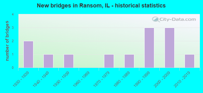
- New bridges - historical statistics
- 21930-1939
- 11940-1949
- 11950-1959
- 11970-1979
- 11980-1989
- 31990-1999
- 32000-2009
- 12010-2019


- Bridge Condition - Deck
- 41.7%Very good
- 41.7%Good
- 16.7%Satisfactory

- Bridge Condition - Superstructure
- 41.7%Very good
- 41.7%Good
- 16.7%Satisfactory

- Bridge Condition - Substructure
- 58.3%Very good
- 25.0%Good
- 8.3%Satisfactory
- 8.3%Fair

- Bridge Condition - Channel
- 41.7%Very good
- 25.0%Good
- 16.7%Satisfactory
- 16.7%Fair
Find on map >> Show street view
Structure Number: 500258, Location: 4.7 M N of IL 17 (Lat: 41.159339, Lng: -88.644603), Route carried "on" structure: State highway 170, Year Built: 2019, Status: Open, Structure Length: 6.10m (20.01ft), Average Daily Traffic: 1,400 (year 2021), Truck Traffic: 16%, Average Future Daily Traffic: 1,612 (year 2038), Design Load: HS 25 or greater, Features Intersected: BNSF Railroad
Minimum Vertical Clearance: 30+ m (98+ ft), Kilometerpoint: 19.167, Lanes on structure: 2, Base Highway Network: Yes, Owner: State Highway Agency, Approaching Roadway Width: 9.8m (32.2ft), Skew: 1 degrees, Material/Design: Steel continuous, Design/Construction: Stringer/Multi-beam, Number Of Spans In Main Unit: 3, Length of Maximum Span: 24.4m (80.1ft), Curb-To-Curb Width: 9.8m (32.2ft), Out-to-Out Width: 10.7m (35.1ft)
Condition: Deck: Very good, Superstructure: Very good, Substructure: Very good, Operating Rating: 52.2 metric tons, Method Used To Determine Operating Rating: Load and Resistance Factor Rating (LRFR) rating reported by rating factor(RF) method using HL-93 loadings, Inventory Rating: 40.2 metric tons, Method Used To Determine Inventory Rating: Load and Resistance Factor Rating (LRFR) rating reported by rating factor(RF) method using HL-93 loadings, Structural Evaluation: Equal to present desirable criteria, Deck Geometry: Somewhat better than minimum adequacy, Approach Roadway Alignment: Equal to present desirable criteria, Designated Inspection Frequency: Every 48 months, Inspection Date: January 2022, Deck Structure Type: Concrete Cast-file-Place, Wearing Surface/Protective System: Deck Protection: Epoxy Coated Reinforcing
Find on map >> Show street view
Structure Number: 503209, Location: E 24TH N 1460 (Lat: 41.143922, Lng: -88.702033), Route carried "on" structure: County highway , Year Built: 1946, Status: Open, Structure Length: 0.79m (2.59ft), Average Daily Traffic: 50 (year 2016), Average Future Daily Traffic: 56 (year 2032), Design Load: H 20, Features Intersected: WOLF CREEK, Facility Carried by Structure: TR 402
Minimum Vertical Clearance: 30+ m (98+ ft), Kilometerpoint: 15.304, Lanes on structure: 2, Owner: Town or Township Highway Agency, Approaching Roadway Width: 5.2m (17.1ft), Material/Design: Concrete, Design/Construction: Slab, Number Of Spans In Main Unit: 1, Length of Maximum Span: 7.6m (24.9ft), Curb-To-Curb Width: 7.4m (24.3ft), Out-to-Out Width: 8.0m (26.2ft)
Condition: Deck: Satisfactory, Superstructure: Satisfactory, Substructure: Satisfactory, Channel: Fair, Operating Rating: 40.5 metric tons, Method Used To Determine Operating Rating: Field evaluation and documented engineering judgment, Inventory Rating: 24.3 metric tons, Method Used To Determine Inventory Rating: Field evaluation and documented engineering judgment, Structural Evaluation: Equal to present minimum criteria, Deck Geometry: Equal to present minimum criteria, Waterway Adequacy: Equal to present minimum criteria, Approach Roadway Alignment: Equal to present desirable criteria, Designated Inspection Frequency: Every 24 months, Inspection Date: June 2020, Deck Structure Type: Concrete Cast-file-Place, Wearing Surface/Protective System: Wearing Surface: Gravel
Find on map >> Show street view
Structure Number: 503232, Location: N 16TH E 2430 (Lat: 41.165408, Lng: -88.695717), Route carried "on" structure: County highway , Year Built: 1935, Year Reconstructed: 1986, Status: Open, Structure Length: 0.82m (2.69ft), Average Daily Traffic: 1,700 (year 2020), Truck Traffic: 1%, Average Future Daily Traffic: 56 (year 2032), Design Load: HS 20, Features Intersected: OTTER CREEK, Facility Carried by Structure: TR 503
Minimum Vertical Clearance: 30+ m (98+ ft), Kilometerpoint: 10.219, Lanes on structure: 2, Owner: Town or Township Highway Agency, Approaching Roadway Width: 4.6m (15.1ft), Material/Design: Prestressed concrete, Design/Construction: Box Beam or Girders - Multiple, Number Of Spans In Main Unit: 1, Length of Maximum Span: 7.6m (24.9ft), Curb-To-Curb Width: 7.3m (24.0ft), Out-to-Out Width: 7.3m (24.0ft)
Condition: Deck: Good, Superstructure: Good, Substructure: Good, Channel: Good, Operating Rating: 59.0 metric tons, Method Used To Determine Operating Rating: Load Factor (LF) rating reported by rating factor (RF) method using MS18 loading, Inventory Rating: 35.3 metric tons, Method Used To Determine Inventory Rating: Load Factor (LF) rating reported by rating factor (RF) method using MS18 loading, Structural Evaluation: Better than present minimum criteria, Deck Geometry: Meets minimum limits, Waterway Adequacy: Equal to present desirable criteria, Approach Roadway Alignment: Equal to present desirable criteria, Designated Inspection Frequency: Every 24 months, Inspection Date: June 2020, Deck Structure Type: Concrete Precast Panels
Find on map >> Show street view
Structure Number: 503456, Location: N 13TH E2490 (Lat: 41.121917, Lng: -88.684983), Route carried "on" structure: County highway , Year Built: 1979, Status: Open, Structure Length: 0.82m (2.69ft), Average Daily Traffic: 600 (year 2020), Truck Traffic: 13%, Average Future Daily Traffic: 503 (year 2032), Design Load: HS 20, Features Intersected: OTTER CREEK, Facility Carried by Structure: CH 40
Minimum Vertical Clearance: 30+ m (98+ ft), Kilometerpoint: 1.738, Lanes on structure: 2, Owner: County Highway Agency, Approaching Roadway Width: 7.3m (24.0ft), Material/Design: Prestressed concrete, Design/Construction: Box Beam or Girders - Multiple, Number Of Spans In Main Unit: 1, Length of Maximum Span: 7.9m (25.9ft), Curb-To-Curb Width: 8.5m (27.9ft), Out-to-Out Width: 9.1m (29.9ft)
Condition: Deck: Satisfactory, Superstructure: Satisfactory, Substructure: Fair, Channel: Satisfactory, Operating Rating: 53.8 metric tons, Method Used To Determine Operating Rating: Load Factor (LF) rating reported by rating factor (RF) method using MS18 loading, Inventory Rating: 32.4 metric tons, Method Used To Determine Inventory Rating: Load Factor (LF) rating reported by rating factor (RF) method using MS18 loading, Structural Evaluation: Somewhat better than minimum adequacy, Deck Geometry: Somewhat better than minimum adequacy, Waterway Adequacy: Equal to present desirable criteria, Approach Roadway Alignment: Equal to present desirable criteria, Designated Inspection Frequency: Every 24 months, Inspection Date: May 2021, Deck Structure Type: Concrete Precast Panels, Wearing Surface/Protective System: Wearing Surface: Bituminous
Find on map >> Show street view
Structure Number: 503501, Location: N 15TH RD E 2370 (Lat: 41.150653, Lng: -88.706119), Route carried "on" structure: County highway , Year Built: 1985, Status: Open, Structure Length: 1.89m (6.20ft), Average Daily Traffic: 200 (year 2020), Truck Traffic: 2%, Average Future Daily Traffic: 363 (year 2032), Design Load: HS 20, Features Intersected: OTTER CREEK, Facility Carried by Structure: TR 523A
Minimum Vertical Clearance: 30+ m (98+ ft), Kilometerpoint: 6.067, Lanes on structure: 2, Owner: Town or Township Highway Agency, Approaching Roadway Width: 6.4m (21.0ft), Material/Design: Prestressed concrete, Design/Construction: Box Beam or Girders - Multiple, Number Of Spans In Main Unit: 2, Length of Maximum Span: 9.1m (29.9ft), Curb-To-Curb Width: 7.3m (24.0ft), Out-to-Out Width: 7.3m (24.0ft)
Condition: Deck: Very good, Superstructure: Very good, Substructure: Good, Channel: Satisfactory, Operating Rating: 44.4 metric tons, Method Used To Determine Operating Rating: Assigned rating based on Load Factor Design (LFD) reported by rating factor (RF) using MS18 loading, Inventory Rating: 32.4 metric tons, Method Used To Determine Inventory Rating: Assigned rating based on Load Factor Design (LFD) reported by rating factor (RF) using MS18 loading, Structural Evaluation: Better than present minimum criteria, Deck Geometry: Somewhat better than minimum adequacy, Waterway Adequacy: Equal to present desirable criteria, Approach Roadway Alignment: Equal to present desirable criteria, Designated Inspection Frequency: Every 48 months, Inspection Date: June 2018, Deck Structure Type: Concrete Precast Panels, Wearing Surface/Protective System: Wearing Surface: Bituminous
Find on map >> Show street view
Structure Number: 503544, Location: E.2410 N 14TH (Lat: 41.136369, Lng: -88.698842), Route carried "on" structure: County highway , Year Built: 1993, Status: Open, Structure Length: 2.48m (8.14ft), Average Daily Traffic: 25 (year 2016), Truck Traffic: 12%, Average Future Daily Traffic: 56 (year 2032), Design Load: HS 20, Features Intersected: OTTER CREEK, Facility Carried by Structure: TR 535
Minimum Vertical Clearance: 30+ m (98+ ft), Kilometerpoint: 8.272, Lanes on structure: 2, Owner: Town or Township Highway Agency, Approaching Roadway Width: 6.1m (20.0ft), Material/Design: Prestressed concrete, Design/Construction: Box Beam or Girders - Multiple, Number Of Spans In Main Unit: 2, Length of Maximum Span: 14.9m (48.9ft), Curb-To-Curb Width: 7.3m (24.0ft), Out-to-Out Width: 7.3m (24.0ft)
Condition: Deck: Very good, Superstructure: Very good, Substructure: Very good, Channel: Good, Operating Rating: 44.1 metric tons, Method Used To Determine Operating Rating: Assigned rating based on Load Factor Design (LFD) reported by rating factor (RF) using MS18 loading, Inventory Rating: 32.4 metric tons, Method Used To Determine Inventory Rating: Assigned rating based on Load Factor Design (LFD) reported by rating factor (RF) using MS18 loading, Structural Evaluation: Equal to present desirable criteria, Deck Geometry: Equal to present minimum criteria, Waterway Adequacy: Equal to present desirable criteria, Approach Roadway Alignment: Equal to present desirable criteria, Designated Inspection Frequency: Every 48 months, Inspection Date: June 2018, Deck Structure Type: Concrete Precast Panels
Find on map >> Show street view
Structure Number: 503546, Location: 3 MI SE RANSOM (Lat: 41.134839, Lng: -88.605675), Route carried "on" structure: County highway , Year Built: 1995, Status: Open, Structure Length: 1.27m (4.17ft), Average Daily Traffic: 25 (year 2016), Average Future Daily Traffic: 28 (year 2032), Design Load: HS 20, Features Intersected: BR WAUPECAN CREEK., Facility Carried by Structure: E.29TH-TR458
Minimum Vertical Clearance: 30+ m (98+ ft), Kilometerpoint: 5.085, Lanes on structure: 2, Owner: Town or Township Highway Agency, Approaching Roadway Width: 6.1m (20.0ft), Skew: 1 degrees, Material/Design: Prestressed concrete, Design/Construction: Box Beam or Girders - Multiple, Number Of Spans In Main Unit: 1, Length of Maximum Span: 11.9m (39.0ft), Curb-To-Curb Width: 7.3m (24.0ft), Out-to-Out Width: 7.3m (24.0ft)
Condition: Deck: Good, Superstructure: Good, Substructure: Very good, Channel: Very good, Operating Rating: 44.1 metric tons, Method Used To Determine Operating Rating: Assigned rating based on Load Factor Design (LFD) reported by rating factor (RF) using MS18 loading, Inventory Rating: 32.4 metric tons, Method Used To Determine Inventory Rating: Assigned rating based on Load Factor Design (LFD) reported by rating factor (RF) using MS18 loading, Structural Evaluation: Better than present minimum criteria, Deck Geometry: Equal to present minimum criteria, Waterway Adequacy: Superior to present desirable criteria, Approach Roadway Alignment: Equal to present desirable criteria, Designated Inspection Frequency: Every 48 months, Inspection Date: June 2018, Deck Structure Type: Concrete Precast Panels
Find on map >> Show street view
Structure Number: 503548, Location: .3M E OF E29TH (Lat: 41.137231, Lng: -88.598811), Route carried "on" structure: County highway , Year Built: 1996, Status: Open, Structure Length: 1.27m (4.17ft), Average Daily Traffic: 25 (year 2016), Truck Traffic: 12%, Average Future Daily Traffic: 11 (year 2032), Design Load: HS 20, Features Intersected: WAUPECAN CREEK, Facility Carried by Structure: TR 535
Minimum Vertical Clearance: 30+ m (98+ ft), Kilometerpoint: 16.624, Lanes on structure: 2, Owner: Town or Township Highway Agency, Approaching Roadway Width: 7.3m (24.0ft), Skew: 1 degrees, Material/Design: Prestressed concrete, Design/Construction: Box Beam or Girders - Multiple, Number Of Spans In Main Unit: 1, Length of Maximum Span: 11.9m (39.0ft), Curb-To-Curb Width: 7.3m (24.0ft), Out-to-Out Width: 7.3m (24.0ft)
Condition: Deck: Good, Superstructure: Good, Substructure: Very good, Channel: Very good, Operating Rating: 44.1 metric tons, Method Used To Determine Operating Rating: Assigned rating based on Load Factor Design (LFD) reported by rating factor (RF) using MS18 loading, Inventory Rating: 32.4 metric tons, Method Used To Determine Inventory Rating: Assigned rating based on Load Factor Design (LFD) reported by rating factor (RF) using MS18 loading, Structural Evaluation: Better than present minimum criteria, Deck Geometry: Equal to present minimum criteria, Waterway Adequacy: Superior to present desirable criteria, Approach Roadway Alignment: Equal to present desirable criteria, Designated Inspection Frequency: Every 48 months, Inspection Date: June 2018, Deck Structure Type: Concrete Precast Panels
Find on map >> Show street view
Structure Number: 503569, Location: 0.8 MI. E. RANSOM (Lat: 41.151528, Lng: -88.628694), Route carried "on" structure: County highway , Year Built: 2000, Status: Open, Structure Length: 1.26m (4.13ft), Average Daily Traffic: 225 (year 2020), Truck Traffic: 5%, Average Future Daily Traffic: 140 (year 2032), Design Load: HS 20, Features Intersected: WAUPECAN CREEK, Facility Carried by Structure: TR 523B
Minimum Vertical Clearance: 30+ m (98+ ft), Kilometerpoint: 6.180, Lanes on structure: 2, Owner: Town or Township Highway Agency, Approaching Roadway Width: 7.3m (24.0ft), Material/Design: Prestressed concrete, Design/Construction: Box Beam or Girders - Multiple, Number Of Spans In Main Unit: 1, Length of Maximum Span: 11.9m (39.0ft), Curb-To-Curb Width: 8.5m (27.9ft), Out-to-Out Width: 8.5m (27.9ft)
Condition: Deck: Good, Superstructure: Good, Substructure: Very good, Channel: Very good, Operating Rating: 44.1 metric tons, Method Used To Determine Operating Rating: Assigned rating based on Load Factor Design (LFD) reported by rating factor (RF) using MS18 loading, Inventory Rating: 32.4 metric tons, Method Used To Determine Inventory Rating: Assigned rating based on Load Factor Design (LFD) reported by rating factor (RF) using MS18 loading, Structural Evaluation: Better than present minimum criteria, Deck Geometry: Equal to present minimum criteria, Waterway Adequacy: Superior to present desirable criteria, Approach Roadway Alignment: Equal to present desirable criteria, Designated Inspection Frequency: Every 48 months, Inspection Date: June 2018, Deck Structure Type: Concrete Precast Panels
Find on map >> Show street view
Structure Number: 503582, Location: 1207 E. 26TH (Lat: 41.108628, Lng: -88.662967), Route carried "on" structure: County highway , Year Built: 2004, Status: Open, Structure Length: 1.27m (4.17ft), Average Daily Traffic: 25 (year 2016), Average Future Daily Traffic: 11 (year 2032), Design Load: HS 20, Features Intersected: UNNAMED STREAM, Facility Carried by Structure: TR432C
Minimum Vertical Clearance: 30+ m (98+ ft), Kilometerpoint: 4.731, Lanes on structure: 2, Owner: Town or Township Highway Agency, Approaching Roadway Width: 7.3m (24.0ft), Material/Design: Prestressed concrete, Design/Construction: Box Beam or Girders - Multiple, Number Of Spans In Main Unit: 1, Length of Maximum Span: 11.9m (39.0ft), Curb-To-Curb Width: 7.3m (24.0ft), Out-to-Out Width: 7.3m (24.0ft)
Condition: Deck: Very good, Superstructure: Very good, Substructure: Very good, Channel: Very good, Operating Rating: 44.1 metric tons, Method Used To Determine Operating Rating: Assigned rating based on Load Factor Design (LFD) reported by rating factor (RF) using MS18 loading, Inventory Rating: 32.4 metric tons, Method Used To Determine Inventory Rating: Assigned rating based on Load Factor Design (LFD) reported by rating factor (RF) using MS18 loading, Structural Evaluation: Equal to present desirable criteria, Deck Geometry: Equal to present minimum criteria, Waterway Adequacy: Superior to present desirable criteria, Approach Roadway Alignment: Equal to present desirable criteria, Designated Inspection Frequency: Every 48 months, Inspection Date: June 2018, Deck Structure Type: Concrete Precast Panels
Find on map >> Show street view
Structure Number: 503588, Location: 1550 E. 28TH (Lat: 41.158894, Lng: -88.625311), Route carried "on" structure: County highway , Year Built: 2005, Status: Open, Structure Length: 1.42m (4.66ft), Average Daily Traffic: 50 (year 2016), Average Future Daily Traffic: 28 (year 2032), Design Load: HS 20, Features Intersected: WAUPECAN CREEK, Facility Carried by Structure: TR 454-B
Minimum Vertical Clearance: 30+ m (98+ ft), Kilometerpoint: 0.805, Lanes on structure: 2, Owner: Town or Township Highway Agency, Approaching Roadway Width: 7.3m (24.0ft), Skew: 1 degrees, Material/Design: Prestressed concrete, Design/Construction: Box Beam or Girders - Multiple, Number Of Spans In Main Unit: 1, Length of Maximum Span: 13.4m (44.0ft), Curb-To-Curb Width: 7.3m (24.0ft), Out-to-Out Width: 7.3m (24.0ft)
Condition: Deck: Very good, Superstructure: Very good, Substructure: Very good, Channel: Good, Operating Rating: 44.1 metric tons, Method Used To Determine Operating Rating: Assigned rating based on Load Factor Design (LFD) reported by rating factor (RF) using MS18 loading, Inventory Rating: 32.4 metric tons, Method Used To Determine Inventory Rating: Assigned rating based on Load Factor Design (LFD) reported by rating factor (RF) using MS18 loading, Structural Evaluation: Equal to present desirable criteria, Deck Geometry: Equal to present minimum criteria, Waterway Adequacy: Superior to present desirable criteria, Approach Roadway Alignment: Equal to present desirable criteria, Designated Inspection Frequency: Every 48 months, Inspection Date: June 2018, Deck Structure Type: Concrete Precast Panels
Find on map >> Show street view
Structure Number: 5036, Location: E 28th, N 1772 (Lat: 41.191169, Lng: -88.625778), Route carried "on" structure: County highway , Year Built: 1930, Status: Open, Structure Length: 0.79m (2.59ft), Average Daily Traffic: 20 (year 2020), Truck Traffic: 10%, Average Future Daily Traffic: 186 (year 2038), Features Intersected: Trib Waupecan Creek, Facility Carried by Structure: TR 454 A
Minimum Vertical Clearance: 30+ m (98+ ft), Kilometerpoint: 0.435, Lanes on structure: 2, Owner: Town or Township Highway Agency, Approaching Roadway Width: 7.0m (23.0ft), Material/Design: Concrete, Design/Construction: Slab, Number Of Spans In Main Unit: 1, Length of Maximum Span: 7.0m (23.0ft), Curb-To-Curb Width: 7.0m (23.0ft), Out-to-Out Width: 7.9m (25.9ft)
Condition: Deck: Good, Superstructure: Good, Substructure: Good, Channel: Very good, Operating Rating: 40.5 metric tons, Method Used To Determine Operating Rating: Field evaluation and documented engineering judgment, Inventory Rating: 24.3 metric tons, Method Used To Determine Inventory Rating: Field evaluation and documented engineering judgment, Structural Evaluation: Equal to present minimum criteria, Deck Geometry: Somewhat better than minimum adequacy, Waterway Adequacy: Better than present minimum criteria, Approach Roadway Alignment: Equal to present desirable criteria, Designated Inspection Frequency: Every 24 months, Inspection Date: June 2020, Deck Structure Type: Concrete Cast-file-Place, Wearing Surface/Protective System: Wearing Surface: Gravel
Find on map >> Show street view
Structure Number: 505011, Location: E 24TH N 1550 (Lat: 41.158144, Lng: -88.702269), Route carried "on" structure: County highway , Year Built: 1959, Status: Open, Structure Length: 1.52m (4.99ft), Average Daily Traffic: 50 (year 2016), Average Future Daily Traffic: 56 (year 2032), Features Intersected: OTTER CREEK, Facility Carried by Structure: TR 402
Minimum Vertical Clearance: 30+ m (98+ ft), Kilometerpoint: 13.711, Lanes on structure: 2, Owner: Town or Township Highway Agency, Approaching Roadway Width: 4.9m (16.1ft), Material/Design: Steel, Design/Construction: Culvert, Number Of Spans In Main Unit: 4, Length of Maximum Span: 3.7m (12.1ft), Curb-To-Curb Width: 4.9m (16.1ft), Out-to-Out Width: 4.9m (16.1ft)
Condition: Channel: Fair, Culverts: Poor, Operating Rating: 40.5 metric tons, Method Used To Determine Operating Rating: Field evaluation and documented engineering judgment, Inventory Rating: 24.3 metric tons, Method Used To Determine Inventory Rating: Field evaluation and documented engineering judgment, Structural Evaluation: Meets minimum limits, Deck Geometry: High priority of corrective action, Waterway Adequacy: Equal to present minimum criteria, Approach Roadway Alignment: Better than present minimum criteria, Designated Inspection Frequency: Every 24 months, Inspection Date: June 2020