Bridge Statistics for Richmond, Vermont (VT)
Condition, Traffic, Stress, Structural Evaluation, Project Costs
- National Bridge Inventory (NBI) Statistics
- 30Number of bridges
- 502ft / 153mTotal length
- $53,389,000Total costs
- 518,535Total average daily traffic
- 63,507Total average daily truck traffic
- National Bridge Inventory (NBI) Registered Bridges for Richmond
- No street view available for this location
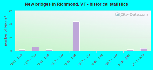
- New bridges - historical statistics
- 11920-1929
- 31930-1939
- 11940-1949
- 221960-1969
- 12000-2009
- 22010-2019

- Reconstructed bridges - Historical Statistics
- 31980-1989
- 01990-1999
- 12000-2009


- Bridge Condition - Deck
- 13.6%Very good
- 27.3%Good
- 40.9%Satisfactory
- 18.2%Fair

- Bridge Condition - Superstructure
- 13.6%Very good
- 50.0%Good
- 31.8%Satisfactory
- 4.5%Fair

- Bridge Condition - Substructure
- 9.1%Very good
- 31.8%Good
- 31.8%Satisfactory
- 22.7%Fair
- 4.5%Poor

- Bridge Condition - Channel
- 72.7%Very good
- 18.2%Good
- 9.1%Satisfactory
Find on map >> Show street view
Structure Number: 100411000704111, Location: 0.27 MI TO JCT W CL2 TH4 (Lat: 44.417331, Lng: -72.990047), Route carried "on" structure: Other road C3033, Year Built: 1934, Status: Open, Structure Length: 1.01m (3.31ft), Average Daily Traffic: 350 (year 2019), Truck Traffic: 2%, Average Future Daily Traffic: 368 (year 2029), Features Intersected: DONAHUE BROOK
Minimum Vertical Clearance: 30+ m (98+ ft), Kilometerpoint: 0.000, Lanes on structure: 2, Owner: Town or Township Highway Agency, Approaching Roadway Width: 7.6m (24.9ft), Skew: 3 degrees, Material/Design: Concrete, Design/Construction: Tee Beam, Number Of Spans In Main Unit: 1, Length of Maximum Span: 9.4m (30.8ft), Curb-To-Curb Width: 6.4m (21.0ft), Out-to-Out Width: 7.1m (23.3ft)
Condition: Deck: Satisfactory, Superstructure: Satisfactory, Substructure: Good, Channel: Good, Operating Rating: 65.3 metric tons, Method Used To Determine Operating Rating: Load Factor (LF), Inventory Rating: 39.0 metric tons, Method Used To Determine Inventory Rating: Load Factor (LF), Structural Evaluation: Equal to present minimum criteria, Deck Geometry: Meets minimum limits, Waterway Adequacy: Equal to present minimum criteria, Approach Roadway Alignment: Equal to present minimum criteria, Length Of Structure Improvement: 1.01m (3.31ft), Designated Inspection Frequency: Every 24 months, Inspection Date: September 2021, Bridge Improvement Cost: $270,000, Roadway Improvement Cost: $50,000, Total Project Cost: $320,000 ( Estimate for 2020), Deck Structure Type: Concrete Cast-file-Place, Wearing Surface/Protective System: Wearing Surface: Bituminous
Find on map >> Show street view
Structure Number: 100411000804111, Location: 0.01 MI TO JCT W C3 TH30 (Lat: 44.380942, Lng: -72.941319), Route carried "on" structure: Other road C2003, Year Built: 1937, Year Reconstructed: 1994, Status: Posted for load, Structure Length: 4.21m (13.81ft), Average Daily Traffic: 1,345 (year 2019), Truck Traffic: 3%, Average Future Daily Traffic: 1,413 (year 2029), Design Load: HS 20, Features Intersected: HUNTINGTON RIVER
Minimum Vertical Clearance: 30+ m (98+ ft), Kilometerpoint: 0.000, Lanes on structure: 2, Owner: Town or Township Highway Agency, Approaching Roadway Width: 7.3m (24.0ft), Skew: 1 degrees, Material/Design: Steel continuous, Design/Construction: Stringer/Multi-beam, Number Of Spans In Main Unit: 2, Length of Maximum Span: 20.7m (67.9ft), Curb or Sidewalk Widths: Left: 0.1m (0.3ft), Right: 0.1m (0.3ft), Curb-To-Curb Width: 8.3m (27.2ft), Out-to-Out Width: 9.1m (29.9ft)
Condition: Deck: Good, Superstructure: Very good, Substructure: Good, Channel: Very good, Operating Rating: 68.0 metric tons, Method Used To Determine Operating Rating: Allowable Stress (AS), Inventory Rating: 40.8 metric tons, Method Used To Determine Inventory Rating: Allowable Stress (AS), Structural Evaluation: Better than present minimum criteria, Deck Geometry: Meets minimum limits, Waterway Adequacy: Better than present minimum criteria, Approach Roadway Alignment: Equal to present desirable criteria, Designated Inspection Frequency: Every 24 months, Inspection Date: September 2021, Deck Structure Type: Concrete Cast-file-Place, Wearing Surface/Protective System: Wearing Surface: Bituminous, Membrane: Preformed Fabric, Deck Protection: Epoxy Coated Reinforcing
Find on map >> Show street view
Structure Number: 100411001004111, Location: 0.02 MI TO JCT W US2 (Lat: 44.382994, Lng: -72.937400), Route carried "on" structure: Other road C2003, Year Built: 2002, Status: Open, Structure Length: 7.53m (24.70ft), Average Daily Traffic: 1,500 (year 2019), Truck Traffic: 1%, Average Future Daily Traffic: 1,575 (year 2029), Design Load: HS 25 or greater, Features Intersected: WINOOSKI RIVER
Minimum Vertical Clearance: 30+ m (98+ ft), Kilometerpoint: 0.000, Lanes on structure: 2, Owner: Town or Township Highway Agency, Approaching Roadway Width: 9.8m (32.2ft), Material/Design: Steel continuous, Design/Construction: Stringer/Multi-beam, Number Of Spans In Main Unit: 2, Length of Maximum Span: 36.9m (121.1ft), Curb or Sidewalk Widths: Left: 0.2m (0.7ft), Right: 0.2m (0.7ft), Curb-To-Curb Width: 9.1m (29.9ft), Out-to-Out Width: 10.4m (34.1ft)
Condition: Deck: Very good, Superstructure: Very good, Substructure: Very good, Channel: Very good, Operating Rating: 79.8 metric tons, Method Used To Determine Operating Rating: Load Factor (LF), Inventory Rating: 47.2 metric tons, Method Used To Determine Inventory Rating: Load Factor (LF), Structural Evaluation: Equal to present desirable criteria, Deck Geometry: Somewhat better than minimum adequacy, Waterway Adequacy: Superior to present desirable criteria, Approach Roadway Alignment: Equal to present desirable criteria, Designated Inspection Frequency: Every 24 months, Inspection Date: September 2021, Deck Structure Type: Concrete Cast-file-Place, Wearing Surface/Protective System: Wearing Surface: Bituminous, Membrane: Preformed Fabric, Deck Protection: Epoxy Coated Reinforcing
Find on map >> Show street view
Structure Number: 200089052N04112, Location: 4.8 MI S EXIT 11 (Lat: 44.385528, Lng: -72.935211), Route carried "on" structure: Interstate 89, Year Built: 1964, Status: Open, Structure Length: 5.70m (18.70ft), Average Daily Traffic: 28,200 (year 2018), Truck Traffic: 13%, Average Future Daily Traffic: 29,610 (year 2028), Design Load: HS 20, Features Intersected: I 89 OVER TH NO 14
Minimum Vertical Clearance: 30+ m (98+ ft), Kilometerpoint: 118.342, Lanes on structure: 2, Lanes under structure: 2, Base Highway Network: Yes, Owner: State Highway Agency, Approaching Roadway Width: 11.6m (38.1ft), Skew: 10 degrees, Material/Design: Steel, Design/Construction: Stringer/Multi-beam, Number Of Spans In Main Unit: 3, Length of Maximum Span: 18.9m (62.0ft), Curb or Sidewalk Widths: Left: 0.2m (0.7ft), Right: 0.2m (0.7ft), Curb-To-Curb Width: 9.1m (29.9ft), Out-to-Out Width: 10.7m (35.1ft)
Condition: Deck: Fair, Superstructure: Satisfactory, Substructure: Fair, Operating Rating: 89.8 metric tons, Method Used To Determine Operating Rating: Load Factor (LF), Inventory Rating: 56.2 metric tons, Method Used To Determine Inventory Rating: Load Factor (LF), Structural Evaluation: Somewhat better than minimum adequacy, Deck Geometry: High priority of replacement, Underclear: Superior to present desirable criteria, Approach Roadway Alignment: Equal to present desirable criteria, Length Of Structure Improvement: 5.70m (18.70ft), Designated Inspection Frequency: Every 24 months, Inspection Date: May 2020, Bridge Improvement Cost: $2,291,000, Roadway Improvement Cost: $50,000, Total Project Cost: $2,341,000 ( Estimate for 2020), Deck Structure Type: Concrete Cast-file-Place, Wearing Surface/Protective System: Wearing Surface: Bituminous
Find on map >> Show street view
Structure Number: 200089052S04112, Location: 4.8 MI S EXIT 11 (Lat: 44.385256, Lng: -72.935606), Route carried "on" structure: Interstate 89, Year Built: 1964, Status: Open, Structure Length: 3.72m (12.20ft), Average Daily Traffic: 28,200 (year 2018), Truck Traffic: 13%, Average Future Daily Traffic: 29,610 (year 2028), Design Load: HS 20, Features Intersected: I 89 OVER TH NO 14
Minimum Vertical Clearance: 30+ m (98+ ft), Kilometerpoint: 118.342, Lanes on structure: 2, Lanes under structure: 2, Base Highway Network: Yes, Owner: State Highway Agency, Approaching Roadway Width: 12.5m (41.0ft), Skew: 10 degrees, Material/Design: Steel, Design/Construction: Stringer/Multi-beam, Number Of Spans In Main Unit: 3, Length of Maximum Span: 14.3m (46.9ft), Curb or Sidewalk Widths: Left: 0.2m (0.7ft), Right: 0.2m (0.7ft), Curb-To-Curb Width: 11.6m (38.1ft), Out-to-Out Width: 13.2m (43.3ft)
Condition: Deck: Good, Superstructure: Good, Substructure: Good, Operating Rating: 89.8 metric tons, Method Used To Determine Operating Rating: Load Factor (LF), Inventory Rating: 79.8 metric tons, Method Used To Determine Inventory Rating: Load Factor (LF), Structural Evaluation: Better than present minimum criteria, Deck Geometry: Equal to present minimum criteria, Underclear: Equal to present minimum criteria, Approach Roadway Alignment: Equal to present desirable criteria, Designated Inspection Frequency: Every 24 months, Inspection Date: May 2020, Deck Structure Type: Concrete Cast-file-Place, Wearing Surface/Protective System: Wearing Surface: Bituminous, Membrane: Preformed Fabric
Find on map >> Show street view
Structure Number: 200089053N04112, Location: 4.4 MI S EXIT 11 (Lat: 44.388742, Lng: -72.942778), Route carried "on" structure: Interstate 89, Year Built: 1964, Status: Open, Structure Length: 6.31m (20.70ft), Average Daily Traffic: 28,200 (year 2018), Truck Traffic: 13%, Average Future Daily Traffic: 29,610 (year 2028), Design Load: HS 20, Features Intersected: I 89 OVER US 2
Minimum Vertical Clearance: 30+ m (98+ ft), Kilometerpoint: 119.066, Lanes on structure: 2, Lanes under structure: 2, Base Highway Network: Yes, Owner: State Highway Agency, Approaching Roadway Width: 11.6m (38.1ft), Skew: 13 degrees, Material/Design: Steel, Design/Construction: Stringer/Multi-beam, Number Of Spans In Main Unit: 3, Length of Maximum Span: 21.9m (71.9ft), Curb or Sidewalk Widths: Left: 0.2m (0.7ft), Right: 0.2m (0.7ft), Curb-To-Curb Width: 9.1m (29.9ft), Out-to-Out Width: 10.7m (35.1ft)
Condition: Deck: Fair, Superstructure: Good, Substructure: Fair, Operating Rating: 89.8 metric tons, Method Used To Determine Operating Rating: Load Factor (LF), Inventory Rating: 58.1 metric tons, Method Used To Determine Inventory Rating: Load Factor (LF), Structural Evaluation: Somewhat better than minimum adequacy, Deck Geometry: Meets minimum limits, Underclear: Equal to present minimum criteria, Approach Roadway Alignment: Equal to present desirable criteria, Length Of Structure Improvement: 6.31m (20.70ft), Designated Inspection Frequency: Every 24 months, Inspection Date: May 2020, Bridge Improvement Cost: $2,550,000, Roadway Improvement Cost: $50,000, Total Project Cost: $2,600,000 ( Estimate for 2020), Deck Structure Type: Concrete Cast-file-Place, Wearing Surface/Protective System: Wearing Surface: Bituminous
Find on map >> Show street view
Structure Number: 200089053S04112, Location: 4.4 MI S EXIT 11 (Lat: 44.387828, Lng: -72.942058), Route carried "on" structure: Interstate 89, Year Built: 1964, Status: Open, Structure Length: 7.53m (24.70ft), Average Daily Traffic: 28,200 (year 2018), Truck Traffic: 13%, Average Future Daily Traffic: 29,610 (year 2028), Design Load: HS 20, Features Intersected: I 89 OVER US 2
Minimum Vertical Clearance: 30+ m (98+ ft), Kilometerpoint: 119.066, Lanes on structure: 2, Lanes under structure: 2, Base Highway Network: Yes, Owner: State Highway Agency, Approaching Roadway Width: 11.6m (38.1ft), Skew: 14 degrees, Material/Design: Steel, Design/Construction: Stringer/Multi-beam, Number Of Spans In Main Unit: 3, Length of Maximum Span: 24.7m (81.0ft), Curb or Sidewalk Widths: Left: 0.2m (0.7ft), Right: 0.2m (0.7ft), Curb-To-Curb Width: 9.1m (29.9ft), Out-to-Out Width: 10.7m (35.1ft)
Condition: Deck: Satisfactory, Superstructure: Good, Substructure: Fair, Operating Rating: 89.8 metric tons, Method Used To Determine Operating Rating: Load Factor (LF), Inventory Rating: 61.7 metric tons, Method Used To Determine Inventory Rating: Load Factor (LF), Structural Evaluation: Somewhat better than minimum adequacy, Deck Geometry: Meets minimum limits, Underclear: Somewhat better than minimum adequacy, Approach Roadway Alignment: Equal to present desirable criteria, Length Of Structure Improvement: 7.53m (24.70ft), Designated Inspection Frequency: Every 24 months, Inspection Date: May 2020, Bridge Improvement Cost: $3,043,000, Roadway Improvement Cost: $50,000, Total Project Cost: $3,093,000 ( Estimate for 2020), Deck Structure Type: Concrete Cast-file-Place, Wearing Surface/Protective System: Wearing Surface: Bituminous, Membrane: Preformed Fabric
Find on map >> Show street view
Structure Number: 200089055N04112, Location: 1.3 MI S EXIT 11 (Lat: 44.411939, Lng: -72.991231), Route carried "on" structure: Interstate 89, Year Built: 1964, Status: Open, Structure Length: 4.63m (15.19ft), Average Daily Traffic: 28,200 (year 2018), Truck Traffic: 13%, Average Future Daily Traffic: 29,610 (year 2028), Design Load: HS 20, Features Intersected: I 89 OVER TH NO 4
Minimum Vertical Clearance: 30+ m (98+ ft), Kilometerpoint: 124.054, Lanes on structure: 2, Lanes under structure: 2, Base Highway Network: Yes, Owner: State Highway Agency, Approaching Roadway Width: 11.6m (38.1ft), Skew: 13 degrees, Material/Design: Steel, Design/Construction: Stringer/Multi-beam, Number Of Spans In Main Unit: 3, Length of Maximum Span: 17.4m (57.1ft), Curb or Sidewalk Widths: Left: 0.3m (1.0ft), Right: 0.3m (1.0ft), Curb-To-Curb Width: 9.1m (29.9ft), Out-to-Out Width: 10.7m (35.1ft)
Condition: Deck: Satisfactory, Superstructure: Good, Substructure: Satisfactory, Operating Rating: 69.9 metric tons, Method Used To Determine Operating Rating: Load Factor (LF), Inventory Rating: 39.9 metric tons, Method Used To Determine Inventory Rating: Load Factor (LF), Structural Evaluation: Equal to present minimum criteria, Deck Geometry: High priority of replacement, Underclear: Equal to present minimum criteria, Approach Roadway Alignment: Equal to present desirable criteria, Length Of Structure Improvement: 4.63m (15.19ft), Designated Inspection Frequency: Every 24 months, Inspection Date: May 2020, Bridge Improvement Cost: $1,862,000, Roadway Improvement Cost: $50,000, Total Project Cost: $1,912,000 ( Estimate for 2020), Deck Structure Type: Concrete Cast-file-Place, Wearing Surface/Protective System: Wearing Surface: Bituminous
Find on map >> Show street view
Structure Number: 200089055S04112, Location: 1.3 MI S EXIT 11 (Lat: 44.411747, Lng: -72.991464), Route carried "on" structure: Interstate 89, Year Built: 1964, Status: Open, Structure Length: 4.94m (16.21ft), Average Daily Traffic: 28,200 (year 2018), Truck Traffic: 13%, Average Future Daily Traffic: 29,610 (year 2028), Design Load: HS 20, Features Intersected: I 89 OVER TH NO 4
Minimum Vertical Clearance: 30+ m (98+ ft), Kilometerpoint: 124.054, Lanes on structure: 2, Lanes under structure: 2, Base Highway Network: Yes, Owner: State Highway Agency, Approaching Roadway Width: 11.6m (38.1ft), Skew: 13 degrees, Material/Design: Steel, Design/Construction: Stringer/Multi-beam, Number Of Spans In Main Unit: 3, Length of Maximum Span: 18.6m (61.0ft), Curb or Sidewalk Widths: Left: 0.3m (1.0ft), Right: 0.3m (1.0ft), Curb-To-Curb Width: 9.1m (29.9ft), Out-to-Out Width: 10.7m (35.1ft)
Condition: Deck: Satisfactory, Superstructure: Good, Substructure: Good, Operating Rating: 63.5 metric tons, Method Used To Determine Operating Rating: Load Factor (LF), Inventory Rating: 38.1 metric tons, Method Used To Determine Inventory Rating: Load Factor (LF), Structural Evaluation: Better than present minimum criteria, Deck Geometry: High priority of replacement, Underclear: Equal to present minimum criteria, Approach Roadway Alignment: Equal to present desirable criteria, Length Of Structure Improvement: 4.94m (16.21ft), Designated Inspection Frequency: Every 24 months, Inspection Date: May 2020, Bridge Improvement Cost: $1,984,000, Roadway Improvement Cost: $50,000, Total Project Cost: $2,035,000 ( Estimate for 2020), Deck Structure Type: Concrete Cast-file-Place, Wearing Surface/Protective System: Wearing Surface: Bituminous, Membrane: Preformed Fabric
Find on map >> Show street view
Structure Number: 200089056N04112, Location: I 89 EXIT 11 (Lat: 44.424061, Lng: -73.010417), Route carried "on" structure: Interstate 89, Year Built: 1964, Status: Open, Structure Length: 7.07m (23.20ft), Average Daily Traffic: 28,200 (year 2018), Truck Traffic: 13%, Average Future Daily Traffic: 29,610 (year 2028), Design Load: HS 20, Features Intersected: I 89 OVER US 2
Minimum Vertical Clearance: 30+ m (98+ ft), Kilometerpoint: 126.162, Lanes on structure: 3, Lanes under structure: 2, Base Highway Network: Yes, Owner: State Highway Agency, Approaching Roadway Width: 13.7m (44.9ft), Skew: 15 degrees, Material/Design: Steel, Design/Construction: Stringer/Multi-beam, Number Of Spans In Main Unit: 3, Length of Maximum Span: 29.3m (96.1ft), Curb or Sidewalk Widths: Left: 0.3m (1.0ft), Right: 0.3m (1.0ft), Curb-To-Curb Width: 12.8m (42.0ft), Out-to-Out Width: 14.3m (46.9ft)
Condition: Deck: Fair, Superstructure: Good, Substructure: Satisfactory, Operating Rating: 89.8 metric tons, Method Used To Determine Operating Rating: Load Factor (LF), Inventory Rating: 62.6 metric tons, Method Used To Determine Inventory Rating: Load Factor (LF), Structural Evaluation: Equal to present minimum criteria, Deck Geometry: Meets minimum limits, Underclear: Superior to present desirable criteria, Approach Roadway Alignment: Equal to present desirable criteria, Length Of Structure Improvement: 7.07m (23.20ft), Designated Inspection Frequency: Every 24 months, Inspection Date: May 2020, Bridge Improvement Cost: $3,816,000, Roadway Improvement Cost: $50,000, Total Project Cost: $3,866,000 ( Estimate for 2020), Deck Structure Type: Concrete Cast-file-Place, Wearing Surface/Protective System: Wearing Surface: Bituminous
Find on map >> Show street view
Structure Number: 200089056S04112, Location: I 89 EXIT 11 (Lat: 44.423850, Lng: -73.010106), Route carried "on" structure: Interstate 89, Year Built: 1964, Status: Open, Structure Length: 6.77m (22.21ft), Average Daily Traffic: 28,200 (year 2018), Truck Traffic: 13%, Average Future Daily Traffic: 29,610 (year 2028), Design Load: HS 20, Features Intersected: I 89 OVER US 2
Minimum Vertical Clearance: 30+ m (98+ ft), Kilometerpoint: 126.162, Lanes on structure: 2, Lanes under structure: 2, Base Highway Network: Yes, Owner: State Highway Agency, Approaching Roadway Width: 11.6m (38.1ft), Skew: 15 degrees, Material/Design: Steel, Design/Construction: Stringer/Multi-beam, Number Of Spans In Main Unit: 3, Length of Maximum Span: 27.7m (90.9ft), Curb or Sidewalk Widths: Left: 0.3m (1.0ft), Right: 0.3m (1.0ft), Curb-To-Curb Width: 9.1m (29.9ft), Out-to-Out Width: 10.7m (35.1ft)
Condition: Deck: Satisfactory, Superstructure: Good, Substructure: Satisfactory, Operating Rating: 89.8 metric tons, Method Used To Determine Operating Rating: Load Factor (LF), Inventory Rating: 56.2 metric tons, Method Used To Determine Inventory Rating: Load Factor (LF), Structural Evaluation: Equal to present minimum criteria, Deck Geometry: Meets minimum limits, Underclear: Superior to present desirable criteria, Approach Roadway Alignment: Equal to present desirable criteria, Designated Inspection Frequency: Every 24 months, Inspection Date: May 2020, Deck Structure Type: Concrete Cast-file-Place, Wearing Surface/Protective System: Wearing Surface: Bituminous
Find on map >> Show street view
Structure Number: 200089057N04112, Location: 0.1 MI N EXIT 11 (Lat: 44.423694, Lng: -73.012292), Route carried "on" structure: Interstate 89, Year Built: 1964, Status: Open, Structure Length: 7.65m (25.10ft), Average Daily Traffic: 36,300 (year 2018), Truck Traffic: 13%, Average Future Daily Traffic: 38,115 (year 2028), Design Load: HS 20, Features Intersected: I 89 OVER NECRR & BROOK
Minimum Vertical Clearance: 30+ m (98+ ft), Kilometerpoint: 126.307, Lanes on structure: 2, Lanes under structure: 1, Base Highway Network: Yes, Owner: State Highway Agency, Approaching Roadway Width: 11.6m (38.1ft), Skew: 10 degrees, Material/Design: Steel, Design/Construction: Stringer/Multi-beam, Number Of Spans In Main Unit: 4, Length of Maximum Span: 18.9m (62.0ft), Curb or Sidewalk Widths: Left: 0.2m (0.7ft), Right: 0.2m (0.7ft), Curb-To-Curb Width: 9.1m (29.9ft), Out-to-Out Width: 10.7m (35.1ft)
Condition: Deck: Fair, Superstructure: Satisfactory, Substructure: Fair, Channel: Very good, Operating Rating: 83.5 metric tons, Method Used To Determine Operating Rating: Load Factor (LF), Inventory Rating: 49.9 metric tons, Method Used To Determine Inventory Rating: Load Factor (LF), Structural Evaluation: Somewhat better than minimum adequacy, Deck Geometry: Meets minimum limits, Underclear: Better than present minimum criteria, Approach Roadway Alignment: Equal to present desirable criteria, Length Of Structure Improvement: 7.65m (25.10ft), Designated Inspection Frequency: Every 24 months, Inspection Date: May 2020, Bridge Improvement Cost: $3,075,000, Roadway Improvement Cost: $50,000, Total Project Cost: $3,125,000 ( Estimate for 2020), Deck Structure Type: Concrete Cast-file-Place, Wearing Surface/Protective System: Wearing Surface: Bituminous
Find on map >> Show street view
Structure Number: 200089057S04112, Location: 0.1 MI N EXIT 11 (Lat: 44.423497, Lng: -73.012186), Route carried "on" structure: Interstate 89, Year Built: 1964, Status: Open, Structure Length: 7.80m (25.59ft), Average Daily Traffic: 36,300 (year 2018), Truck Traffic: 13%, Average Future Daily Traffic: 38,115 (year 2028), Design Load: HS 20, Features Intersected: I 89 OVER NECRR & BROOK
Minimum Vertical Clearance: 30+ m (98+ ft), Kilometerpoint: 126.307, Lanes on structure: 3, Lanes under structure: 1, Base Highway Network: Yes, Owner: State Highway Agency, Approaching Roadway Width: 12.5m (41.0ft), Skew: 10 degrees, Material/Design: Steel, Design/Construction: Stringer/Multi-beam, Number Of Spans In Main Unit: 4, Length of Maximum Span: 21.9m (71.9ft), Curb or Sidewalk Widths: Left: 0.2m (0.7ft), Right: 0.2m (0.7ft), Curb-To-Curb Width: 12.8m (42.0ft), Out-to-Out Width: 14.3m (46.9ft)
Condition: Deck: Satisfactory, Superstructure: Satisfactory, Substructure: Satisfactory, Channel: Very good, Operating Rating: 68.9 metric tons, Method Used To Determine Operating Rating: Load Factor (LF), Inventory Rating: 40.8 metric tons, Method Used To Determine Inventory Rating: Load Factor (LF), Structural Evaluation: Equal to present minimum criteria, Deck Geometry: Meets minimum limits, Underclear: Equal to present minimum criteria, Approach Roadway Alignment: Equal to present desirable criteria, Length Of Structure Improvement: 7.80m (25.59ft), Designated Inspection Frequency: Every 24 months, Inspection Date: May 2020, Bridge Improvement Cost: $4,211,000, Roadway Improvement Cost: $50,000, Total Project Cost: $4,261,000 ( Estimate for 2020), Deck Structure Type: Concrete Cast-file-Place, Wearing Surface/Protective System: Wearing Surface: Bituminous
Find on map >> Show street view
Structure Number: 200089058N04112, Location: 0.3 MI N EXIT 11 (Lat: 44.422872, Lng: -73.016417), Route carried "on" structure: Interstate 89, Year Built: 1962, Status: Open, Structure Length: 17.01m (55.81ft), Average Daily Traffic: 36,300 (year 2018), Truck Traffic: 13%, Average Future Daily Traffic: 38,115 (year 2028), Design Load: HS 20, Features Intersected: I 89 OVER WIN. RIV.+TH16
Minimum Vertical Clearance: 30+ m (98+ ft), Kilometerpoint: 126.660, Lanes on structure: 2, Lanes under structure: 2, Base Highway Network: Yes, Owner: State Highway Agency, Approaching Roadway Width: 11.6m (38.1ft), Skew: 10 degrees, Material/Design: Steel continuous, Design/Construction: Girder and Floorbeam System, Number Of Spans In Main Unit: 3, Length of Maximum Span: 70.1m (230.0ft), Curb or Sidewalk Widths: Left: 0.2m (0.7ft), Right: 0.2m (0.7ft), Curb-To-Curb Width: 9.1m (29.9ft), Out-to-Out Width: 10.8m (35.4ft)
Condition: Deck: Satisfactory, Superstructure: Satisfactory, Substructure: Satisfactory, Channel: Very good, Operating Rating: 84.4 metric tons, Method Used To Determine Operating Rating: Allowable Stress (AS), Inventory Rating: 37.2 metric tons, Method Used To Determine Inventory Rating: Allowable Stress (AS), Structural Evaluation: Equal to present minimum criteria, Deck Geometry: Meets minimum limits, Underclear: Superior to present desirable criteria, Waterway Adequacy: Equal to present desirable criteria, Approach Roadway Alignment: Equal to present desirable criteria, Length Of Structure Improvement: 17.01m (55.81ft), Designated Inspection Frequency: Every 24 months, Critical Feature Inspection Frequency: Every 24 months, Inspection Date: May 2020, Critical Feature Inspection Date: May 2020, Bridge Improvement Cost: $6,933,000, Roadway Improvement Cost: $50,000, Total Project Cost: $6,983,000 ( Estimate for 2020), Deck Structure Type: Concrete Cast-file-Place, Wearing Surface/Protective System: Wearing Surface: Bituminous, Membrane: Preformed Fabric
Find on map >> Show street view
Structure Number: 200089058S04112, Location: 0.3 MI N EXIT 11 (Lat: 44.422697, Lng: -73.016247), Route carried "on" structure: Interstate 89, Year Built: 1962, Status: Open, Structure Length: 17.01m (55.81ft), Average Daily Traffic: 36,300 (year 2018), Truck Traffic: 13%, Average Future Daily Traffic: 38,115 (year 2028), Design Load: HS 20, Features Intersected: I 89 OVER WIN. RIV.+TH16
Minimum Vertical Clearance: 30+ m (98+ ft), Kilometerpoint: 126.660, Lanes on structure: 2, Lanes under structure: 2, Base Highway Network: Yes, Owner: State Highway Agency, Approaching Roadway Width: 11.6m (38.1ft), Skew: 10 degrees, Material/Design: Steel continuous, Design/Construction: Girder and Floorbeam System, Number Of Spans In Main Unit: 3, Length of Maximum Span: 70.1m (230.0ft), Curb or Sidewalk Widths: Left: 0.2m (0.7ft), Right: 0.2m (0.7ft), Curb-To-Curb Width: 9.1m (29.9ft), Out-to-Out Width: 10.8m (35.4ft)
Condition: Deck: Satisfactory, Superstructure: Satisfactory, Substructure: Satisfactory, Channel: Very good, Operating Rating: 84.4 metric tons, Method Used To Determine Operating Rating: Allowable Stress (AS), Inventory Rating: 37.2 metric tons, Method Used To Determine Inventory Rating: Allowable Stress (AS), Structural Evaluation: Equal to present minimum criteria, Deck Geometry: Meets minimum limits, Underclear: Superior to present desirable criteria, Waterway Adequacy: Equal to present desirable criteria, Approach Roadway Alignment: Equal to present desirable criteria, Length Of Structure Improvement: 17.01m (55.81ft), Designated Inspection Frequency: Every 24 months, Critical Feature Inspection Frequency: Every 24 months, Inspection Date: May 2020, Critical Feature Inspection Date: May 2020, Bridge Improvement Cost: $6,933,000, Roadway Improvement Cost: $50,000, Total Project Cost: $6,983,000 ( Estimate for 2020), Deck Structure Type: Concrete Cast-file-Place, Wearing Surface/Protective System: Wearing Surface: Bituminous, Membrane: Preformed Fabric
Find on map >> Show street view
Structure Number: 200089059N04112, Location: 0.6 MI N EXIT 11 (Lat: 44.422114, Lng: -73.021331), Route carried "on" structure: Interstate 89, Year Built: 1962, Status: Open, Structure Length: 4.63m (15.19ft), Average Daily Traffic: 36,300 (year 2018), Truck Traffic: 13%, Average Future Daily Traffic: 38,115 (year 2028), Design Load: HS 20, Features Intersected: I 89 OVER TH NO 8
Minimum Vertical Clearance: 30+ m (98+ ft), Kilometerpoint: 127.079, Lanes on structure: 2, Lanes under structure: 2, Base Highway Network: Yes, Owner: State Highway Agency, Approaching Roadway Width: 11.6m (38.1ft), Skew: 13 degrees, Material/Design: Steel, Design/Construction: Stringer/Multi-beam, Number Of Spans In Main Unit: 3, Length of Maximum Span: 15.8m (51.8ft), Curb or Sidewalk Widths: Left: 0.3m (1.0ft), Right: 0.3m (1.0ft), Curb-To-Curb Width: 9.1m (29.9ft), Out-to-Out Width: 10.7m (35.1ft)
Condition: Deck: Good, Superstructure: Good, Substructure: Good, Operating Rating: 89.8 metric tons, Method Used To Determine Operating Rating: Load Factor (LF), Inventory Rating: 53.5 metric tons, Method Used To Determine Inventory Rating: Load Factor (LF), Structural Evaluation: Better than present minimum criteria, Deck Geometry: High priority of replacement, Underclear: Meets minimum limits, Approach Roadway Alignment: Equal to present desirable criteria, Length Of Structure Improvement: 4.63m (15.19ft), Designated Inspection Frequency: Every 24 months, Inspection Date: June 2020, Bridge Improvement Cost: $1,862,000, Roadway Improvement Cost: $50,000, Total Project Cost: $1,912,000 ( Estimate for 2020), Deck Structure Type: Concrete Cast-file-Place, Wearing Surface/Protective System: Wearing Surface: Bituminous, Membrane: Preformed Fabric
Find on map >> Show street view
Structure Number: 200089059S04112, Location: 0.6 MI N EXIT 11 (Lat: 44.421903, Lng: -73.021497), Route carried "on" structure: Interstate 89, Year Built: 1962, Status: Open, Structure Length: 4.63m (15.19ft), Average Daily Traffic: 36,300 (year 2018), Truck Traffic: 13%, Average Future Daily Traffic: 38,115 (year 2028), Design Load: HS 20, Features Intersected: I 89 OVER TH NO 8
Minimum Vertical Clearance: 30+ m (98+ ft), Kilometerpoint: 127.079, Lanes on structure: 2, Lanes under structure: 2, Base Highway Network: Yes, Owner: State Highway Agency, Approaching Roadway Width: 11.6m (38.1ft), Skew: 12 degrees, Material/Design: Steel, Design/Construction: Stringer/Multi-beam, Number Of Spans In Main Unit: 3, Length of Maximum Span: 15.8m (51.8ft), Curb or Sidewalk Widths: Left: 0.3m (1.0ft), Right: 0.3m (1.0ft), Curb-To-Curb Width: 9.1m (29.9ft), Out-to-Out Width: 10.7m (35.1ft)
Condition: Deck: Good, Superstructure: Good, Substructure: Good, Operating Rating: 89.8 metric tons, Method Used To Determine Operating Rating: Load Factor (LF), Inventory Rating: 53.5 metric tons, Method Used To Determine Inventory Rating: Load Factor (LF), Structural Evaluation: Better than present minimum criteria, Deck Geometry: High priority of replacement, Underclear: Somewhat better than minimum adequacy, Approach Roadway Alignment: Equal to present desirable criteria, Length Of Structure Improvement: 4.63m (15.19ft), Designated Inspection Frequency: Every 24 months, Inspection Date: June 2020, Bridge Improvement Cost: $1,862,000, Roadway Improvement Cost: $50,000, Total Project Cost: $1,912,000 ( Estimate for 2020), Deck Structure Type: Concrete Cast-file-Place, Wearing Surface/Protective System: Wearing Surface: Bituminous, Membrane: Preformed Fabric
Find on map >> Show street view
Structure Number: 200209003104112, Location: 0.3 MI S JCT. U.S.2 (Lat: 44.401111, Lng: -72.996914), Route carried "on" structure: County highway 1, Year Built: 1928, Year Reconstructed: 2009, Status: Open, Structure Length: 7.25m (23.79ft), Average Daily Traffic: 5,500 (year 2017), Truck Traffic: 4%, Average Future Daily Traffic: 5,775 (year 2027), Design Load: HS 20, Features Intersected: WINOOSKI RIVER
Minimum Vertical Clearance: 4.59m (15.06ft), Kilometerpoint: 0.000, Lanes on structure: 2, Owner: Town or Township Highway Agency, Approaching Roadway Width: 9.4m (30.8ft), Material/Design: Steel, Design/Construction: Truss - Thru, Number Of Spans In Main Unit: 1, Length of Maximum Span: 70.7m (232.0ft), Curb or Sidewalk Widths: Left: 1.2m (3.9ft), Right: 0.2m (0.7ft), Curb-To-Curb Width: 6.1m (20.0ft), Out-to-Out Width: 6.5m (21.3ft)
Condition: Deck: Good, Superstructure: Satisfactory, Substructure: Good, Channel: Very good, Operating Rating: 54.4 metric tons, Method Used To Determine Operating Rating: Allowable Stress (AS), Inventory Rating: 27.2 metric tons, Method Used To Determine Inventory Rating: Allowable Stress (AS), Structural Evaluation: Equal to present minimum criteria, Deck Geometry: High priority of replacement, Waterway Adequacy: Equal to present desirable criteria, Approach Roadway Alignment: Meets minimum limits, Length Of Structure Improvement: 7.25m (23.79ft), Designated Inspection Frequency: Every 24 months, Critical Feature Inspection Frequency: Every 24 months, Inspection Date: August 2020, Critical Feature Inspection Date: August 2020, Bridge Improvement Cost: $1,783,000, Roadway Improvement Cost: $50,000, Total Project Cost: $1,833,000 ( Estimate for 2020), Deck Structure Type: Closed Grating, Wearing Surface/Protective System: Deck Protection: Galvanized Reinforcing
Find on map >> Show street view
Structure Number: 200211000804082, Location: 3.9 MI N JCT. VT.17 (Lat: 44.263042, Lng: -72.959397), Route carried "on" structure: County highway 1, Year Built: 2017, Status: Open, Structure Length: 2.96m (9.71ft), Average Daily Traffic: 780 (year 2017), Truck Traffic: 10%, Average Future Daily Traffic: 819 (year 2027), Design Load: HL 93, Features Intersected: HUNTINGTON RIVER
Minimum Vertical Clearance: 30+ m (98+ ft), Kilometerpoint: 0.000, Lanes on structure: 2, Owner: Town or Township Highway Agency, Approaching Roadway Width: 7.3m (24.0ft), Skew: 2 degrees, Material/Design: Steel, Design/Construction: Stringer/Multi-beam, Number Of Spans In Main Unit: 1, Length of Maximum Span: 28.7m (94.2ft), Curb-To-Curb Width: 7.3m (24.0ft), Out-to-Out Width: 8.3m (27.2ft)
Condition: Deck: Very good, Superstructure: Very good, Substructure: Very good, Channel: Very good, Operating Rating: 49.9 metric tons, Method Used To Determine Operating Rating: Load and Resistance Factor (LRFR), Inventory Rating: 38.1 metric tons, Method Used To Determine Inventory Rating: Load and Resistance Factor (LRFR), Structural Evaluation: Equal to present desirable criteria, Deck Geometry: Meets minimum limits, Waterway Adequacy: Equal to present minimum criteria, Approach Roadway Alignment: Equal to present desirable criteria, Designated Inspection Frequency: Every 24 months, Inspection Date: August 2020, Deck Structure Type: Concrete Cast-file-Place, Wearing Surface/Protective System: Deck Protection: Epoxy Coated Reinforcing
Find on map >> Show street view
Structure Number: 200211009R04112, Location: 4.6 MI S JCT. U.S.2 (Lat: 44.358478, Lng: -72.993056), Route carried "on" structure: County highway 1, Year Built: 1946, Year Reconstructed: 1980, Status: Open, Structure Length: 5.12m (16.80ft), Average Daily Traffic: 2,400 (year 2017), Truck Traffic: 6%, Average Future Daily Traffic: 2,520 (year 2027), Design Load: H 15, Features Intersected: HUNTINGTON RIVER
Minimum Vertical Clearance: 30+ m (98+ ft), Kilometerpoint: 0.000, Lanes on structure: 2, Owner: Town or Township Highway Agency, Approaching Roadway Width: 8.5m (27.9ft), Material/Design: Steel continuous, Design/Construction: Stringer/Multi-beam, Number Of Spans In Main Unit: 2, Length of Maximum Span: 25.0m (82.0ft), Curb-To-Curb Width: 7.3m (24.0ft), Out-to-Out Width: 7.7m (25.3ft)
Condition: Deck: Good, Superstructure: Good, Substructure: Fair, Channel: Satisfactory, Operating Rating: 71.7 metric tons, Method Used To Determine Operating Rating: Allowable Stress (AS), Inventory Rating: 46.3 metric tons, Method Used To Determine Inventory Rating: Allowable Stress (AS), Structural Evaluation: Somewhat better than minimum adequacy, Deck Geometry: High priority of replacement, Waterway Adequacy: Equal to present desirable criteria, Approach Roadway Alignment: Equal to present desirable criteria, Length Of Structure Improvement: 5.12m (16.80ft), Designated Inspection Frequency: Every 24 months, Inspection Date: August 2020, Bridge Improvement Cost: $1,494,000, Roadway Improvement Cost: $50,000, Total Project Cost: $1,544,000 ( Estimate for 2020), Deck Structure Type: Concrete Cast-file-Place, Wearing Surface/Protective System: Deck Protection: Epoxy Coated Reinforcing
Find on map >> Show street view
Structure Number: 200284002504112, Location: 0.1 MI W JCT VT.117 (Lat: 44.424258, Lng: -73.012625), Route carried "on" structure: US 2, Year Built: 1938, Year Reconstructed: 1993, Status: Open, Structure Length: 3.66m (12.01ft), Average Daily Traffic: 3,200 (year 2018), Truck Traffic: 6%, Average Future Daily Traffic: 3,360 (year 2028), Design Load: HS 20, Features Intersected: US 2 OVER NECRR
Minimum Vertical Clearance: 30+ m (98+ ft), Kilometerpoint: 0.000, Lanes on structure: 2, Owner: State Highway Agency, Approaching Roadway Width: 9.4m (30.8ft), Skew: 1 degrees, Material/Design: Steel, Design/Construction: Stringer/Multi-beam, Number Of Spans In Main Unit: 3, Length of Maximum Span: 14.3m (46.9ft), Curb or Sidewalk Widths: Left: 0.4m (1.3ft), Right: 0.4m (1.3ft), Curb-To-Curb Width: 8.7m (28.5ft), Out-to-Out Width: 9.4m (30.8ft)
Condition: Deck: Very good, Superstructure: Good, Substructure: Satisfactory, Operating Rating: 89.8 metric tons, Method Used To Determine Operating Rating: Load Factor (LF), Inventory Rating: 68.0 metric tons, Method Used To Determine Inventory Rating: Load Factor (LF), Structural Evaluation: Equal to present minimum criteria, Deck Geometry: Meets minimum limits, Underclear: Meets minimum limits, Approach Roadway Alignment: Equal to present desirable criteria, Length Of Structure Improvement: 3.66m (12.01ft), Designated Inspection Frequency: Every 24 months, Inspection Date: May 2021, Bridge Improvement Cost: $1,294,000, Roadway Improvement Cost: $50,000, Total Project Cost: $1,344,000 ( Estimate for 2020), Deck Structure Type: Concrete Cast-file-Place, Wearing Surface/Protective System: Wearing Surface: Bituminous, Membrane: Preformed Fabric, Deck Protection: Epoxy Coated Reinforcing
Find on map >> Show street view
Structure Number: 200284002904112, Location: 1.9 MI E JCT VT 117 (Lat: 44.400842, Lng: -72.984436), Route carried "on" structure: US 2, Year Built: 1964, Status: Open, Structure Length: 15.15m (49.70ft), Average Daily Traffic: 8,400 (year 2018), Truck Traffic: 6%, Average Future Daily Traffic: 8,820 (year 2028), Design Load: HS 20, Features Intersected: I 89 UNDER US 2
Minimum Vertical Clearance: 30+ m (98+ ft), Kilometerpoint: 0.000, Lanes on structure: 2, Lanes under structure: 4, Owner: State Highway Agency, Approaching Roadway Width: 10.4m (34.1ft), Skew: 6 degrees, Material/Design: Steel, Design/Construction: Stringer/Multi-beam, Number Of Spans In Main Unit: 8, Length of Maximum Span: 24.4m (80.1ft), Curb or Sidewalk Widths: Left: 0.3m (1.0ft), Right: 0.3m (1.0ft), Curb-To-Curb Width: 9.1m (29.9ft), Out-to-Out Width: 10.7m (35.1ft)
Condition: Deck: Satisfactory, Superstructure: Fair, Substructure: Poor, Operating Rating: 89.8 metric tons, Method Used To Determine Operating Rating: Load Factor (LF), Inventory Rating: 56.2 metric tons, Method Used To Determine Inventory Rating: Load Factor (LF), Structural Evaluation: Meets minimum limits, Deck Geometry: Meets minimum limits, Underclear: High priority of replacement, Approach Roadway Alignment: Equal to present desirable criteria, Length Of Structure Improvement: 16.67m (54.69ft), Designated Inspection Frequency: Every 12 months, Inspection Date: April 2021, Bridge Improvement Cost: $7,175,000, Roadway Improvement Cost: $150,000, Total Project Cost: $7,325,000 ( Estimate for 2020), Deck Structure Type: Concrete Cast-file-Place, Wearing Surface/Protective System: Wearing Surface: Bituminous, Membrane: Preformed Fabric
Find on map >> Show street view
Structure Number: 200284003204112, Location: 4.2 MI E JCT VT 117 (Lat: 44.394292, Lng: -72.950583), Route carried "on" structure: US 2, Year Built: 2017, Status: Open, Structure Length: 0.88m (2.89ft), Average Daily Traffic: 2,300 (year 2018), Truck Traffic: 2%, Average Future Daily Traffic: 2,415 (year 2028), Design Load: HL 93, Features Intersected: SNIPE ISLAND BROOK
Minimum Vertical Clearance: 30+ m (98+ ft), Kilometerpoint: 0.000, Lanes on structure: 2, Owner: State Highway Agency, Approaching Roadway Width: 9.1m (29.9ft), Skew: 2 degrees, Material/Design: Concrete, Design/Construction: Culvert, Number Of Spans In Main Unit: 1, Length of Maximum Span: 7.9m (25.9ft), Curb or Sidewalk Widths: Left: 0.2m (0.7ft), Right: 0.2m (0.7ft), Curb-To-Curb Width: 9.3m (30.5ft), Out-to-Out Width: 10.2m (33.5ft)
Condition: Channel: Good, Culverts: Very good, Operating Rating: 41.7 metric tons, Method Used To Determine Operating Rating: Load and Resistance Factor (LRFR), Inventory Rating: 32.7 metric tons, Method Used To Determine Inventory Rating: Load and Resistance Factor (LRFR), Structural Evaluation: Equal to present desirable criteria, Deck Geometry: Meets minimum limits, Waterway Adequacy: Somewhat better than minimum adequacy, Approach Roadway Alignment: Equal to present desirable criteria, Designated Inspection Frequency: Every 24 months, Inspection Date: May 2021, Deck Structure Type: Concrete Precast Panels, Wearing Surface/Protective System: Wearing Surface: Bituminous, Membrane: Epoxy, Deck Protection: Epoxy Coated Reinforcing
Find on map >> Show street view
Structure Number: 200089053N04112, Location: 4.4 MI S EXIT 11 (Lat: 44.388742, Lng: -72.942778), Route carried "under" structure: US 2, Year Built: 1964, Structure Length: 0. m, Average Daily Traffic: 3,200 (year 1998), Truck Traffic: 6%, Features Intersected: I 89 OVER US NO 2, Facility Carried by Structure: I 00089 ML
Minimum Vertical Clearance: 6.52m (21.39ft), Kilometerpoint: 87.552, Lanes on structure: 4, Material/Design: Steel, Design/Construction: Stringer/Multi-beam, Length of Maximum Span: 21.9m (71.9ft)
Find on map >> Show street view
Structure Number: 200089053S04112, Location: 4.4 MI S EXIT 11 (Lat: 44.387828, Lng: -72.942058), Route carried "under" structure: US 2, Year Built: 1964, Structure Length: 0. m, Average Daily Traffic: 3,200 (year 1998), Truck Traffic: 6%, Features Intersected: I 89 OVER US 2, Facility Carried by Structure: I 00089 ML
Minimum Vertical Clearance: 7.51m (24.64ft), Kilometerpoint: 87.552, Lanes on structure: 4, Material/Design: Steel, Design/Construction: Stringer/Multi-beam, Length of Maximum Span: 21.9m (71.9ft)
Find on map >> Show street view
Structure Number: 200089055N04112, Location: 1.3 MI S EXIT 11 (Lat: 44.411939, Lng: -72.991231), Route carried "under" structure: County highway 4, Year Built: 1964, Structure Length: 0. m, Average Daily Traffic: 1,530 (year 1995), Truck Traffic: 6%, Features Intersected: I 89 OVER TH NO 4, Facility Carried by Structure: I 00089 ML
Minimum Vertical Clearance: 4.69m (15.39ft), Kilometerpoint: 0.000, Lanes on structure: 2, Material/Design: Steel, Design/Construction: Stringer/Multi-beam, Length of Maximum Span: 17.4m (57.1ft)
Find on map >> Show street view
Structure Number: 200089055S04112, Location: 1.3 MI S EXIT 11 (Lat: 44.411747, Lng: -72.991464), Route carried "under" structure: County highway 4, Year Built: 1964, Structure Length: 0. m, Average Daily Traffic: 1,530 (year 1995), Truck Traffic: 6%, Features Intersected: I 89 OVER TH NO 4, Facility Carried by Structure: I 00089 ML
Minimum Vertical Clearance: 5.23m (17.16ft), Kilometerpoint: 0.000, Lanes on structure: 2, Material/Design: Steel, Design/Construction: Stringer/Multi-beam, Length of Maximum Span: 17.4m (57.1ft)
Find on map >> Show street view
Structure Number: 200089056N04112, Location: I 89 EXIT 11 (Lat: 44.424061, Lng: -73.010417), Route carried "under" structure: US 2, Year Built: 1964, Structure Length: 0. m, Average Daily Traffic: 8,100 (year 1998), Truck Traffic: 6%, Features Intersected: I 89 OVER U.S.2, Facility Carried by Structure: I 00089 ML
Minimum Vertical Clearance: 5.28m (17.32ft), Kilometerpoint: 0.000, Lanes on structure: 3, Material/Design: Steel, Design/Construction: Stringer/Multi-beam, Length of Maximum Span: 29.3m (96.1ft)
Find on map >> Show street view
Structure Number: 200089056S04112, Location: I 89 EXIT 11 (Lat: 44.423850, Lng: -73.010106), Route carried "under" structure: US 2, Year Built: 1964, Structure Length: 0. m, Average Daily Traffic: 8,100 (year 1998), Truck Traffic: 6%, Features Intersected: I 89 OVER U.S.2, Facility Carried by Structure: I 00089 ML
Minimum Vertical Clearance: 5.79m (19.00ft), Kilometerpoint: 79.962, Lanes on structure: 2, Material/Design: Steel, Design/Construction: Stringer/Multi-beam, Length of Maximum Span: 29.3m (96.1ft)
Find on map >> Show street view
Structure Number: 200284002904112, Location: 1.9 MI E JCT VT 117 (Lat: 44.400842, Lng: -72.984436), Route carried "under" structure: Interstate 89, Year Built: 1964, Structure Length: 0. m, Average Daily Traffic: 23,700 (year 1998), Truck Traffic: 13%, Features Intersected: I 89 UNDER US 2, Facility Carried by Structure: US 00002 ML
Minimum Vertical Clearance: 9.14m (29.99ft), Kilometerpoint: 197.413, Lanes on structure: 2, Material/Design: Steel, Design/Construction: Stringer/Multi-beam, Length of Maximum Span: 24.4m (80.1ft)