Bridge Statistics for Riverside, Missouri (MO)
Condition, Traffic, Stress, Structural Evaluation, Project Costs
- National Bridge Inventory (NBI) Statistics
- 46Number of bridges
- 830ft / 253mTotal length
- $1,224,000Total costs
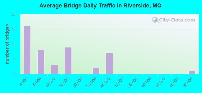
- 492,686Total average daily traffic
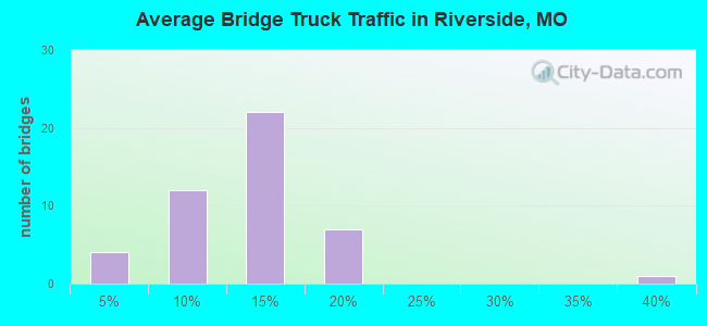
- 62,917Total average daily truck traffic
- National Bridge Inventory (NBI) Registered Bridges for Riverside
- No street view available for this location

- New bridges - historical statistics
- 11950-1959
- 91960-1969
- 231970-1979
- 11980-1989
- 11990-1999
- 22000-2009
- 92010-2019
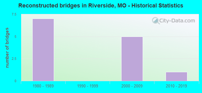
- Reconstructed bridges - Historical Statistics
- 71980-1989
- 01990-1999
- 52000-2009
- 12010-2019
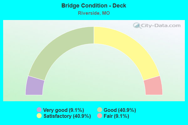
- Bridge Condition - Deck
- 9.1%Very good
- 40.9%Good
- 40.9%Satisfactory
- 9.1%Fair
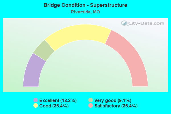
- Bridge Condition - Superstructure
- 18.2%Excellent
- 9.1%Very good
- 36.4%Good
- 36.4%Satisfactory
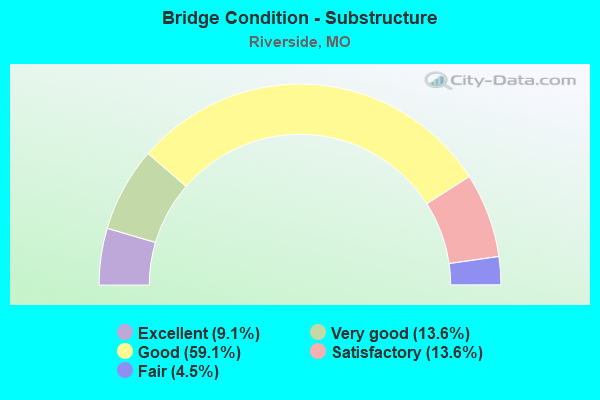
- Bridge Condition - Substructure
- 9.1%Excellent
- 13.6%Very good
- 59.1%Good
- 13.6%Satisfactory
- 4.5%Fair
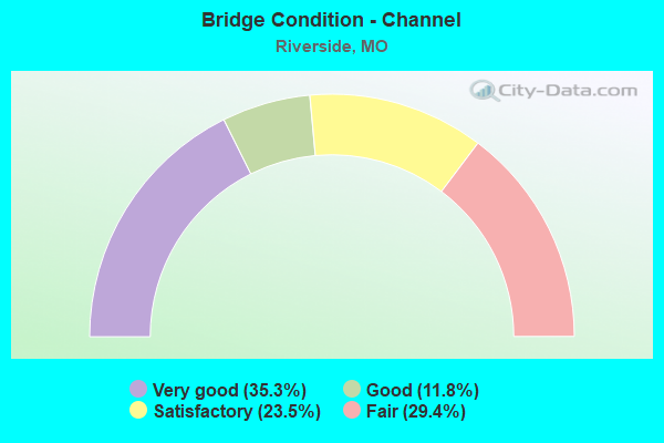
- Bridge Condition - Channel
- 35.3%Very good
- 11.8%Good
- 23.5%Satisfactory
- 29.4%Fair
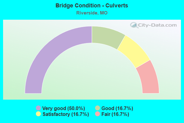
- Bridge Condition - Culverts
- 50.0%Very good
- 16.7%Good
- 16.7%Satisfactory
- 16.7%Fair
Find on map >> Show street view
Structure Number: 1493, Location: S 18 T 50 N R 33 W (Lat: 39.155958, Lng: -94.649517), Route carried "on" structure: Interstate 635, Year Built: 1976, Year Reconstructed: 2012, Status: Posted for load, Structure Length: 49.19m (161.38ft), Average Daily Traffic: 48,116 (year 2021), Truck Traffic: 18%, Average Future Daily Traffic: 98,638 (year 2041), Design Load: H 20, Features Intersected: MISSOURI RVR, UP RR
Minimum Vertical Clearance: 30+ m (98+ ft), Kilometerpoint: 5.454, Lanes on structure: 4, Base Highway Network: Yes, Owner: State Highway Agency, Approaching Roadway Width: 29.3m (96.1ft), Skew: 20 degrees, Navigation Control: Yes ( Vertical Clearance: 15.5m (50.9ft), Horizontal Clearance: 121.9m (399.9ft)), Material/Design: Steel continuous, Design/Construction: Girder and Floorbeam System, Number Of Spans In Main Unit: 6, Length of Maximum Span: 129.5m (424.9ft), Curb-To-Curb Width: 23.8m (78.1ft), Out-to-Out Width: 24.4m (80.1ft)
Condition: Deck: Satisfactory, Superstructure: Satisfactory, Substructure: Fair, Channel: Fair, Operating Rating: 52.2 metric tons, Method Used To Determine Operating Rating: Load Factor (LF), Inventory Rating: 31.5 metric tons, Method Used To Determine Inventory Rating: Load Factor (LF), Structural Evaluation: Somewhat better than minimum adequacy, Deck Geometry: Superior to present desirable criteria, Underclear: Superior to present desirable criteria, Waterway Adequacy: Equal to present desirable criteria, Approach Roadway Alignment: Equal to present desirable criteria, Designated Inspection Frequency: Every 24 months, Critical Feature Inspection Frequency: Every 24 months, Underwater Inspection Frequency: Every 60 months, Inspection Date: August 2021, Critical Feature Inspection Date: August 2021, Underwater Inspection Date: May 2018, Deck Structure Type: Concrete Cast-file-Place, Wearing Surface/Protective System: Wearing Surface: Low Slump Concrete, Deck Protection: Epoxy Coated Reinforcing
Find on map >> Show street view
Structure Number: 1701, Location: S 4 T 50 N R 33 W (Lat: 39.166775, Lng: -94.613056), Route carried "on" structure: State highway 9, Year Built: 1969, Year Reconstructed: 1989, Status: Open, Structure Length: 4.15m (13.62ft), Average Daily Traffic: 7,137 (year 2021), Truck Traffic: 3%, Average Future Daily Traffic: 14,631 (year 2041), Design Load: H 20, Features Intersected: US 69
Minimum Vertical Clearance: 30+ m (98+ ft), Kilometerpoint: 8.710, Lanes on structure: 2, Lanes under structure: 2, Base Highway Network: Yes, Owner: State Highway Agency, Approaching Roadway Width: 11.6m (38.1ft), Skew: 1 degrees, Material/Design: Steel continuous, Design/Construction: Stringer/Multi-beam, Number Of Spans In Main Unit: 3, Length of Maximum Span: 17.1m (56.1ft), Curb-To-Curb Width: 11.6m (38.1ft), Out-to-Out Width: 12.4m (40.7ft)
Condition: Deck: Fair, Superstructure: Good, Substructure: Satisfactory, Operating Rating: 72.9 metric tons, Method Used To Determine Operating Rating: Load Factor (LF), Inventory Rating: 44.1 metric tons, Method Used To Determine Inventory Rating: Load Factor (LF), Structural Evaluation: Equal to present minimum criteria, Deck Geometry: Equal to present minimum criteria, Underclear: Equal to present minimum criteria, Approach Roadway Alignment: Equal to present desirable criteria, Designated Inspection Frequency: Every 24 months, Inspection Date: October 2020, Deck Structure Type: Concrete Cast-file-Place, Wearing Surface/Protective System: Wearing Surface: Bituminous, Membrane: Built-up
Find on map >> Show street view
Structure Number: 1715, Location: S 4 T 50 N R 33 W (Lat: 39.168186, Lng: -94.616881), Route carried "on" structure: US 69, Year Built: 1969, Year Reconstructed: 1989, Status: Posted for load, Structure Length: 9.57m (31.40ft), Average Daily Traffic: 10,727 (year 2021), Truck Traffic: 12%, Average Future Daily Traffic: 21,990 (year 2041), Design Load: H 20, Features Intersected: LINE CR
Minimum Vertical Clearance: 30+ m (98+ ft), Kilometerpoint: 2.150, Lanes on structure: 2, Base Highway Network: Yes, Owner: State Highway Agency, Approaching Roadway Width: 15.2m (49.9ft), Skew: 3 degrees, Material/Design: Steel continuous, Design/Construction: Stringer/Multi-beam, Number Of Spans In Main Unit: 3, Length of Maximum Span: 36.9m (121.1ft), Curb-To-Curb Width: 14.0m (45.9ft), Out-to-Out Width: 14.8m (48.6ft)
Condition: Deck: Satisfactory, Superstructure: Satisfactory, Substructure: Satisfactory, Channel: Satisfactory, Operating Rating: 55.8 metric tons, Method Used To Determine Operating Rating: Load Factor (LF), Inventory Rating: 33.3 metric tons, Method Used To Determine Inventory Rating: Load Factor (LF), Structural Evaluation: Equal to present minimum criteria, Deck Geometry: Superior to present desirable criteria, Waterway Adequacy: Equal to present desirable criteria, Approach Roadway Alignment: Equal to present desirable criteria, Designated Inspection Frequency: Every 24 months, Inspection Date: October 2020, Deck Structure Type: Concrete Cast-file-Place, Wearing Surface/Protective System: Wearing Surface: Bituminous
Find on map >> Show street view
Structure Number: 1716, Location: S 4 T 50 N R 33 W (Lat: 39.168467, Lng: -94.616939), Route carried "on" structure: US 69, Year Built: 1969, Year Reconstructed: 1989, Status: Posted for load, Structure Length: 9.57m (31.40ft), Average Daily Traffic: 10,176 (year 2021), Truck Traffic: 15%, Average Future Daily Traffic: 20,861 (year 2041), Design Load: H 20, Features Intersected: LINE CR
Minimum Vertical Clearance: 30+ m (98+ ft), Kilometerpoint: 193.415, Lanes on structure: 3, Base Highway Network: Yes, Owner: State Highway Agency, Approaching Roadway Width: 15.2m (49.9ft), Skew: 3 degrees, Material/Design: Steel continuous, Design/Construction: Stringer/Multi-beam, Number Of Spans In Main Unit: 3, Length of Maximum Span: 36.9m (121.1ft), Curb-To-Curb Width: 14.0m (45.9ft), Out-to-Out Width: 14.8m (48.6ft)
Condition: Deck: Fair, Superstructure: Satisfactory, Substructure: Satisfactory, Channel: Satisfactory, Operating Rating: 55.8 metric tons, Method Used To Determine Operating Rating: Load Factor (LF), Inventory Rating: 33.3 metric tons, Method Used To Determine Inventory Rating: Load Factor (LF), Structural Evaluation: Equal to present minimum criteria, Deck Geometry: Meets minimum limits, Waterway Adequacy: Equal to present desirable criteria, Approach Roadway Alignment: Equal to present desirable criteria, Designated Inspection Frequency: Every 24 months, Inspection Date: October 2020, Deck Structure Type: Concrete Cast-file-Place, Wearing Surface/Protective System: Wearing Surface: Bituminous
Find on map >> Show street view
Structure Number: 1717, Location: S 4 T 50 N R 33 W (Lat: 39.167825, Lng: -94.616811), Route carried "on" structure: ServiceState highway 9, Year Built: 1969, Year Reconstructed: 2010, Status: Posted for load, Structure Length: 9.56m (31.36ft), Average Daily Traffic: 4,315 (year 2021), Truck Traffic: 2%, Average Future Daily Traffic: 7,767 (year 2041), Design Load: HS 20, Features Intersected: LINE CR
Minimum Vertical Clearance: 30+ m (98+ ft), Kilometerpoint: 0.486, Lanes on structure: 2, Owner: State Highway Agency, Approaching Roadway Width: 7.3m (24.0ft), Skew: 3 degrees, Material/Design: Steel continuous, Design/Construction: Stringer/Multi-beam, Number Of Spans In Main Unit: 3, Length of Maximum Span: 36.9m (121.1ft), Curb-To-Curb Width: 8.5m (27.9ft), Out-to-Out Width: 9.1m (29.9ft)
Condition: Deck: Good, Superstructure: Satisfactory, Substructure: Good, Channel: Satisfactory, Operating Rating: 36.0 metric tons, Method Used To Determine Operating Rating: Load Factor (LF), Inventory Rating: 21.6 metric tons, Method Used To Determine Inventory Rating: Load Factor (LF), Structural Evaluation: Somewhat better than minimum adequacy, Deck Geometry: Meets minimum limits, Waterway Adequacy: Equal to present desirable criteria, Approach Roadway Alignment: Equal to present desirable criteria, Designated Inspection Frequency: Every 24 months, Inspection Date: October 2020, Deck Structure Type: Concrete Cast-file-Place, Wearing Surface/Protective System: Wearing Surface: Monolithic Concrete, Deck Protection: Epoxy Coated Reinforcing
Find on map >> Show street view
Structure Number: 1762, Location: S 31 T 50 N R 33 W (Lat: 39.178003, Lng: -94.649444), Route carried "on" structure: State highway 9, Year Built: 1968, Status: Open, Structure Length: 1.25m (4.10ft), Average Daily Traffic: 13,944 (year 2021), Truck Traffic: 5%, Average Future Daily Traffic: 26,494 (year 2041), Design Load: H 20, Features Intersected: BURLINGTON CR
Minimum Vertical Clearance: 30+ m (98+ ft), Kilometerpoint: 10.721, Lanes on structure: 4, Owner: State Highway Agency, Approaching Roadway Width: 8.5m (27.9ft), Skew: 24 degrees, Material/Design: Concrete continuous, Design/Construction: Culvert, Number Of Spans In Main Unit: 2, Length of Maximum Span: 4.3m (14.1ft)
Condition: Channel: Fair, Culverts: Satisfactory, Operating Rating: 87.3 metric tons, Method Used To Determine Operating Rating: Field evaluation and documented engineering judgment, Inventory Rating: 52.2 metric tons, Method Used To Determine Inventory Rating: Field evaluation and documented engineering judgment, Structural Evaluation: Equal to present minimum criteria, Waterway Adequacy: Equal to present desirable criteria, Approach Roadway Alignment: Better than present minimum criteria, Designated Inspection Frequency: Every 24 months, Inspection Date: December 2020
Find on map >> Show street view
Structure Number: 21, Location: S 5 T 50 N R 33 W (Lat: 39.168497, Lng: -94.624789), Route carried "on" structure: Interstate 635, Year Built: 1969, Year Reconstructed: 1991, Status: Open, Structure Length: 6.61m (21.69ft), Average Daily Traffic: 24,872 (year 2021), Truck Traffic: 13%, Average Future Daily Traffic: 50,988 (year 2041), Design Load: H 20, Features Intersected: OR 635, BNSF RR
Minimum Vertical Clearance: 30+ m (98+ ft), Kilometerpoint: 3.109, Lanes on structure: 5, Lanes under structure: 1, Base Highway Network: Yes, Owner: State Highway Agency, Approaching Roadway Width: 23.2m (76.1ft), Material/Design: Steel continuous, Design/Construction: Stringer/Multi-beam, Number Of Spans In Main Unit: 4, Length of Maximum Span: 19.8m (65.0ft), Curb-To-Curb Width: 23.2m (76.1ft), Out-to-Out Width: 24.0m (78.7ft)
Condition: Deck: Satisfactory, Superstructure: Good, Substructure: Good, Operating Rating: 58.5 metric tons, Method Used To Determine Operating Rating: Load Factor (LF), Inventory Rating: 35.1 metric tons, Method Used To Determine Inventory Rating: Load Factor (LF), Structural Evaluation: Better than present minimum criteria, Deck Geometry: Somewhat better than minimum adequacy, Underclear: Better than present minimum criteria, Approach Roadway Alignment: Equal to present desirable criteria, Designated Inspection Frequency: Every 24 months, Inspection Date: October 2020, Deck Structure Type: Concrete Cast-file-Place, Wearing Surface/Protective System: Wearing Surface: Low Slump Concrete
Find on map >> Show street view
Structure Number: 2103, Location: S 5 T 50 N R 33 W (Lat: 39.171736, Lng: -94.623050), Route carried "on" structure: US 69, Year Built: 1972, Year Reconstructed: 2013, Status: Open, Structure Length: 6.07m (19.91ft), Average Daily Traffic: 4,794 (year 2021), Truck Traffic: 6%, Average Future Daily Traffic: 9,109 (year 2041), Design Load: HS 20, Features Intersected: MO 9
Minimum Vertical Clearance: 30+ m (98+ ft), Kilometerpoint: 194.100, Lanes on structure: 1, Lanes under structure: 3, Base Highway Network: Yes, Owner: State Highway Agency, Approaching Roadway Width: 8.5m (27.9ft), Material/Design: Steel continuous, Design/Construction: Girder and Floorbeam System, Number Of Spans In Main Unit: 3, Length of Maximum Span: 25.0m (82.0ft), Curb-To-Curb Width: 7.3m (24.0ft), Out-to-Out Width: 8.2m (26.9ft)
Condition: Deck: Very good, Superstructure: Very good, Substructure: Good, Operating Rating: 72.0 metric tons, Method Used To Determine Operating Rating: Load Factor (LF), Inventory Rating: 43.2 metric tons, Method Used To Determine Inventory Rating: Load Factor (LF), Structural Evaluation: Better than present minimum criteria, Deck Geometry: High priority of replacement, Underclear: Somewhat better than minimum adequacy, Approach Roadway Alignment: Equal to present desirable criteria, Designated Inspection Frequency: Every 24 months, Critical Feature Inspection Frequency: Every 24 months, Inspection Date: December 2020, Critical Feature Inspection Date: December 2020, Deck Structure Type: Concrete Cast-file-Place, Wearing Surface/Protective System: Wearing Surface: Monolithic Concrete, Deck Protection: Epoxy Coated Reinforcing
Find on map >> Show street view
Structure Number: 2104, Location: S 5 T 50 N R 33 W (Lat: 39.171775, Lng: -94.623306), Route carried "on" structure: Interstate 635, Year Built: 1972, Year Reconstructed: 2014, Status: Posted for load, Structure Length: 9.24m (30.31ft), Average Daily Traffic: 24,872 (year 2021), Truck Traffic: 13%, Average Future Daily Traffic: 50,988 (year 2041), Design Load: HS 20, Features Intersected: MO 9, US 69
Minimum Vertical Clearance: 30+ m (98+ ft), Kilometerpoint: 3.500, Lanes on structure: 4, Lanes under structure: 4, Base Highway Network: Yes, Owner: State Highway Agency, Approaching Roadway Width: 20.7m (67.9ft), Material/Design: Steel continuous, Design/Construction: Stringer/Multi-beam, Number Of Spans In Main Unit: 4, Length of Maximum Span: 25.9m (85.0ft), Curb-To-Curb Width: 19.5m (64.0ft), Out-to-Out Width: 20.4m (66.9ft)
Condition: Deck: Very good, Superstructure: Very good, Substructure: Good, Operating Rating: 51.3 metric tons, Method Used To Determine Operating Rating: Load Factor (LF), Inventory Rating: 30.6 metric tons, Method Used To Determine Inventory Rating: Load Factor (LF), Structural Evaluation: Better than present minimum criteria, Deck Geometry: Somewhat better than minimum adequacy, Underclear: Meets minimum limits, Approach Roadway Alignment: Equal to present desirable criteria, Designated Inspection Frequency: Every 24 months, Critical Feature Inspection Frequency: Every 24 months, Inspection Date: December 2020, Critical Feature Inspection Date: December 2020, Deck Structure Type: Concrete Cast-file-Place, Wearing Surface/Protective System: Wearing Surface: Monolithic Concrete, Deck Protection: Epoxy Coated Reinforcing
Find on map >> Show street view
Structure Number: 2107, Location: S 5 T 50 N R 33 W (Lat: 39.173375, Lng: -94.623344), Route carried "on" structure: Interstate 635, Year Built: 1972, Year Reconstructed: 1991, Status: Open, Structure Length: 3.72m (12.20ft), Average Daily Traffic: 26,897 (year 2021), Truck Traffic: 18%, Average Future Daily Traffic: 55,139 (year 2041), Design Load: HS 20, Features Intersected: MO 9
Minimum Vertical Clearance: 30+ m (98+ ft), Kilometerpoint: 2.266, Lanes on structure: 3, Lanes under structure: 1, Base Highway Network: Yes, Owner: State Highway Agency, Approaching Roadway Width: 15.8m (51.8ft), Material/Design: Concrete continuous, Design/Construction: Slab, Number Of Spans In Main Unit: 3, Length of Maximum Span: 16.2m (53.1ft), Curb-To-Curb Width: 17.1m (56.1ft), Out-to-Out Width: 17.9m (58.7ft)
Condition: Deck: Satisfactory, Superstructure: Satisfactory, Substructure: Good, Operating Rating: 55.8 metric tons, Method Used To Determine Operating Rating: Load Factor (LF), Inventory Rating: 33.3 metric tons, Method Used To Determine Inventory Rating: Load Factor (LF), Structural Evaluation: Equal to present minimum criteria, Deck Geometry: Equal to present minimum criteria, Underclear: Somewhat better than minimum adequacy, Approach Roadway Alignment: Equal to present desirable criteria, Designated Inspection Frequency: Every 24 months, Inspection Date: October 2020, Deck Structure Type: Concrete Cast-file-Place, Wearing Surface/Protective System: Wearing Surface: Low Slump Concrete
Find on map >> Show street view
Structure Number: 2149, Location: S 4 T 50 N R 33 W (Lat: 39.177881, Lng: -94.622231), Route carried "on" structure: Interstate 635, Year Built: 1972, Year Reconstructed: 1991, Status: Posted for load, Structure Length: 4.45m (14.60ft), Average Daily Traffic: 26,897 (year 2021), Truck Traffic: 18%, Average Future Daily Traffic: 55,139 (year 2041), Design Load: HS 20, Features Intersected: CST HIGH DR
Minimum Vertical Clearance: 30+ m (98+ ft), Kilometerpoint: 1.749, Lanes on structure: 3, Lanes under structure: 2, Base Highway Network: Yes, Owner: State Highway Agency, Approaching Roadway Width: 15.2m (49.9ft), Skew: 1 degrees, Material/Design: Concrete continuous, Design/Construction: Slab, Number Of Spans In Main Unit: 3, Length of Maximum Span: 21.3m (69.9ft), Curb-To-Curb Width: 15.2m (49.9ft), Out-to-Out Width: 15.9m (52.2ft)
Condition: Deck: Satisfactory, Superstructure: Satisfactory, Substructure: Good, Operating Rating: 57.6 metric tons, Method Used To Determine Operating Rating: Load Factor (LF), Inventory Rating: 35.1 metric tons, Method Used To Determine Inventory Rating: Load Factor (LF), Structural Evaluation: Equal to present minimum criteria, Deck Geometry: Meets minimum limits, Underclear: Meets minimum limits, Approach Roadway Alignment: Equal to present desirable criteria, Designated Inspection Frequency: Every 24 months, Inspection Date: October 2020, Deck Structure Type: Concrete Cast-file-Place, Wearing Surface/Protective System: Wearing Surface: Low Slump Concrete
Find on map >> Show street view
Structure Number: 2227, Location: S 4 T 50 N R 33 W (Lat: 39.177864, Lng: -94.621942), Route carried "on" structure: Interstate 635, Year Built: 1972, Year Reconstructed: 1991, Status: Posted for load, Structure Length: 5.49m (18.01ft), Average Daily Traffic: 26,631 (year 2021), Truck Traffic: 14%, Average Future Daily Traffic: 54,594 (year 2041), Design Load: HS 20, Features Intersected: CST HIGH DR
Minimum Vertical Clearance: 30+ m (98+ ft), Kilometerpoint: 4.210, Lanes on structure: 4, Lanes under structure: 2, Base Highway Network: Yes, Owner: State Highway Agency, Approaching Roadway Width: 18.9m (62.0ft), Skew: 1 degrees, Material/Design: Concrete continuous, Design/Construction: Slab, Number Of Spans In Main Unit: 3, Length of Maximum Span: 21.3m (69.9ft), Curb-To-Curb Width: 17.7m (58.1ft), Out-to-Out Width: 18.5m (60.7ft)
Condition: Deck: Satisfactory, Superstructure: Satisfactory, Substructure: Good, Operating Rating: 52.2 metric tons, Method Used To Determine Operating Rating: Load Factor (LF), Inventory Rating: 31.5 metric tons, Method Used To Determine Inventory Rating: Load Factor (LF), Structural Evaluation: Equal to present minimum criteria, Deck Geometry: Meets minimum limits, Underclear: Meets minimum limits, Approach Roadway Alignment: Equal to present desirable criteria, Designated Inspection Frequency: Every 24 months, Inspection Date: October 2020, Deck Structure Type: Concrete Cast-file-Place, Wearing Surface/Protective System: Wearing Surface: Low Slump Concrete
Find on map >> Show street view
Structure Number: 22739, Location: S 4 T 50 N R 33 W (Lat: 39.163494, Lng: -94.617672), Route carried "on" structure: City street , Year Built: 1996, Status: Open, Structure Length: 4.97m (16.31ft), Average Daily Traffic: 600 (year 2020), Truck Traffic: 10%, Average Future Daily Traffic: 1,140 (year 2040), Design Load: HS 20, Features Intersected: LINE CR, Facility Carried by Structure: ARGOSY CASINO PKWY
Minimum Vertical Clearance: 30+ m (98+ ft), Kilometerpoint: 0.483, Lanes on structure: 3, Owner: City or Municipal Highway Agency, Approaching Roadway Width: 11.0m (36.1ft), Skew: 3 degrees, Material/Design: Prestressed concrete, Design/Construction: Stringer/Multi-beam, Number Of Spans In Main Unit: 3, Length of Maximum Span: 18.3m (60.0ft), Curb or Sidewalk Widths: Left: 1.2m (3.9ft), Right: 1.2m (3.9ft), Curb-To-Curb Width: 11.0m (36.1ft), Out-to-Out Width: 14.6m (47.9ft)
Condition: Deck: Good, Superstructure: Good, Substructure: Good, Channel: Satisfactory, Operating Rating: 54.0 metric tons, Method Used To Determine Operating Rating: Load Factor (LF), Inventory Rating: 32.4 metric tons, Method Used To Determine Inventory Rating: Load Factor (LF), Structural Evaluation: Better than present minimum criteria, Deck Geometry: High priority of replacement, Waterway Adequacy: Better than present minimum criteria, Approach Roadway Alignment: Equal to present desirable criteria, Designated Inspection Frequency: Every 24 months, Inspection Date: April 2020, Deck Structure Type: Concrete Cast-file-Place
Find on map >> Show street view
Structure Number: 2381, Location: S 8 T 50 N R 33 W (Lat: 39.160558, Lng: -94.632064), Route carried "on" structure: Interstate 635, Year Built: 1973, Year Reconstructed: 2006, Status: Open, Structure Length: 3.73m (12.24ft), Average Daily Traffic: 23,193 (year 2021), Truck Traffic: 13%, Average Future Daily Traffic: 47,546 (year 2041), Design Load: HS 20, Features Intersected: DRAIN DTCH
Minimum Vertical Clearance: 30+ m (98+ ft), Kilometerpoint: 1.938, Lanes on structure: 3, Base Highway Network: Yes, Owner: State Highway Agency, Approaching Roadway Width: 15.2m (49.9ft), Material/Design: Concrete continuous, Design/Construction: Slab, Number Of Spans In Main Unit: 3, Length of Maximum Span: 14.6m (47.9ft), Curb-To-Curb Width: 15.2m (49.9ft), Out-to-Out Width: 16.1m (52.8ft)
Condition: Deck: Good, Superstructure: Good, Substructure: Good, Channel: Very good, Operating Rating: 57.6 metric tons, Method Used To Determine Operating Rating: Load Factor (LF), Inventory Rating: 35.1 metric tons, Method Used To Determine Inventory Rating: Load Factor (LF), Structural Evaluation: Better than present minimum criteria, Deck Geometry: Meets minimum limits, Waterway Adequacy: Equal to present desirable criteria, Approach Roadway Alignment: Equal to present desirable criteria, Designated Inspection Frequency: Every 24 months, Inspection Date: October 2020, Deck Structure Type: Concrete Cast-file-Place, Wearing Surface/Protective System: Wearing Surface: Other
Find on map >> Show street view
Structure Number: 243, Location: S 6 T 41 N R 31 W (Lat: 38.395111, Lng: -94.393528), Route carried "on" structure: State highway 18, Year Built: 1958, Status: Open, Structure Length: 0.81m (2.66ft), Average Daily Traffic: 1,164 (year 2021), Truck Traffic: 13%, Average Future Daily Traffic: 1,571 (year 2041), Design Load: H 15, Features Intersected: MILLSAP BR
Minimum Vertical Clearance: 30+ m (98+ ft), Kilometerpoint: 28.651, Lanes on structure: 2, Owner: State Highway Agency, Approaching Roadway Width: 7.3m (24.0ft), Skew: 2 degrees, Material/Design: Concrete continuous, Design/Construction: Culvert, Number Of Spans In Main Unit: 2, Length of Maximum Span: 3.7m (12.1ft), Curb-To-Curb Width: 8.2m (26.9ft), Out-to-Out Width: 8.8m (28.9ft)
Condition: Channel: Fair, Culverts: Fair, Operating Rating: 64.8 metric tons, Method Used To Determine Operating Rating: Load Factor (LF), Inventory Rating: 38.7 metric tons, Method Used To Determine Inventory Rating: Load Factor (LF), Structural Evaluation: Somewhat better than minimum adequacy, Deck Geometry: Meets minimum limits, Waterway Adequacy: Equal to present desirable criteria, Approach Roadway Alignment: Equal to present desirable criteria, Designated Inspection Frequency: Every 24 months, Inspection Date: March 2020
Find on map >> Show street view
Structure Number: 243, Location: S 8 T 50 N R 33 W (Lat: 39.160833, Lng: -94.632042), Route carried "on" structure: Interstate 635, Year Built: 1973, Year Reconstructed: 2006, Status: Open, Structure Length: 3.73m (12.24ft), Average Daily Traffic: 24,927 (year 2021), Truck Traffic: 18%, Average Future Daily Traffic: 51,100 (year 2041), Design Load: HS 20, Features Intersected: DRAIN DTCH
Minimum Vertical Clearance: 30+ m (98+ ft), Kilometerpoint: 3.938, Lanes on structure: 3, Base Highway Network: Yes, Owner: State Highway Agency, Approaching Roadway Width: 15.2m (49.9ft), Material/Design: Concrete continuous, Design/Construction: Slab, Number Of Spans In Main Unit: 3, Length of Maximum Span: 14.6m (47.9ft), Curb-To-Curb Width: 15.2m (49.9ft), Out-to-Out Width: 16.1m (52.8ft)
Condition: Deck: Good, Superstructure: Good, Substructure: Good, Channel: Very good, Operating Rating: 57.6 metric tons, Method Used To Determine Operating Rating: Load Factor (LF), Inventory Rating: 35.1 metric tons, Method Used To Determine Inventory Rating: Load Factor (LF), Structural Evaluation: Better than present minimum criteria, Deck Geometry: Meets minimum limits, Waterway Adequacy: Equal to present desirable criteria, Approach Roadway Alignment: Equal to present desirable criteria, Designated Inspection Frequency: Every 24 months, Inspection Date: October 2020, Deck Structure Type: Concrete Cast-file-Place, Wearing Surface/Protective System: Wearing Surface: Other, Membrane: Built-up
Find on map >> Show street view
Structure Number: 2775, Location: S 19 T 52 N R 33 W (Lat: 39.307356, Lng: -94.648947), Route carried "on" structure: Interstate 435, Year Built: 1979, Status: Open, Structure Length: 6.49m (21.29ft), Average Daily Traffic: 8,184 (year 2021), Truck Traffic: 37%, Average Future Daily Traffic: 16,777 (year 2041), Design Load: HS 20, Features Intersected: RT C
Minimum Vertical Clearance: 30+ m (98+ ft), Kilometerpoint: 27.547, Lanes on structure: 3, Lanes under structure: 4, Base Highway Network: Yes, Owner: State Highway Agency, Approaching Roadway Width: 17.1m (56.1ft), Skew: 10 degrees, Material/Design: Concrete continuous, Design/Construction: Slab, Number Of Spans In Main Unit: 4, Length of Maximum Span: 19.8m (65.0ft), Curb or Sidewalk Widths: Left: 0.2m (0.7ft), Right: 0.2m (0.7ft), Curb-To-Curb Width: 17.1m (56.1ft), Out-to-Out Width: 18.1m (59.4ft)
Condition: Deck: Satisfactory, Superstructure: Satisfactory, Substructure: Good, Operating Rating: 83.7 metric tons, Method Used To Determine Operating Rating: Load Factor (LF), Inventory Rating: 50.4 metric tons, Method Used To Determine Inventory Rating: Load Factor (LF), Structural Evaluation: Equal to present minimum criteria, Deck Geometry: Equal to present minimum criteria, Underclear: Meets minimum limits, Approach Roadway Alignment: Equal to present desirable criteria, Designated Inspection Frequency: Every 24 months, Inspection Date: October 2020, Deck Structure Type: Concrete Cast-file-Place, Wearing Surface/Protective System: Wearing Surface: Monolithic Concrete, Membrane: Epoxy, Deck Protection: Epoxy Coated Reinforcing
Find on map >> Show street view
Structure Number: 33329, Location: S 5 T 50 N R 33 W (Lat: 39.173244, Lng: -94.640022), Route carried "on" structure: City street , Year Built: 2008, Status: Open, Structure Length: 8.91m (29.23ft), Average Daily Traffic: 600 (year 2020), Truck Traffic: 10%, Average Future Daily Traffic: 1,140 (year 2040), Features Intersected: BNSF RR, Facility Carried by Structure: HORIZONS PKWY
Minimum Vertical Clearance: 30+ m (98+ ft), Kilometerpoint: 0.230, Lanes on structure: 4, Owner: City or Municipal Highway Agency, Approaching Roadway Width: 25.6m (84.0ft), Skew: 20 degrees, Material/Design: Steel continuous, Design/Construction: Stringer/Multi-beam, Number Of Spans In Main Unit: 3, Length of Maximum Span: 47.2m (154.9ft), Curb or Sidewalk Widths: Left: 1.5m (4.9ft), Right: 1.5m (4.9ft), Curb-To-Curb Width: 25.2m (82.7ft), Out-to-Out Width: 29.7m (97.4ft)
Condition: Deck: Satisfactory, Superstructure: Excellent, Substructure: Very good, Operating Rating: 54.9 metric tons, Method Used To Determine Operating Rating: Load Factor (LF), Inventory Rating: 32.4 metric tons, Method Used To Determine Inventory Rating: Load Factor (LF), Structural Evaluation: Equal to present desirable criteria, Deck Geometry: Superior to present desirable criteria, Underclear: Superior to present desirable criteria, Approach Roadway Alignment: Equal to present desirable criteria, Designated Inspection Frequency: Every 24 months, Inspection Date: April 2020, Deck Structure Type: Concrete Cast-file-Place, Wearing Surface/Protective System: Wearing Surface: Monolithic Concrete, Deck Protection: Epoxy Coated Reinforcing
Find on map >> Show street view
Structure Number: 34742, Location: S 4 T 50 N R 33 W (Lat: 39.173917, Lng: -94.615111), Route carried "on" structure: City street , Year Built: 2010, Status: Open, Structure Length: 9.30m (30.51ft), Average Daily Traffic: 500 (year 2020), Truck Traffic: 10%, Average Future Daily Traffic: 950 (year 2040), Design Load: HS 20, Features Intersected: LINE CR, Facility Carried by Structure: CLIFFVIEW DR
Minimum Vertical Clearance: 30+ m (98+ ft), Kilometerpoint: 0.322, Lanes on structure: 2, Owner: City or Municipal Highway Agency, Approaching Roadway Width: 12.4m (40.7ft), Skew: 1 degrees, Material/Design: Prestressed concrete continuous, Design/Construction: Stringer/Multi-beam, Number Of Spans In Main Unit: 5, Length of Maximum Span: 27.4m (89.9ft), Curb or Sidewalk Widths: Left: 2.0m (6.6ft), Right: 0.0m, Curb-To-Curb Width: 9.8m (32.2ft), Out-to-Out Width: 12.4m (40.7ft)
Condition: Deck: Good, Superstructure: Excellent, Substructure: Good, Channel: Very good, Operating Rating: 97.2 metric tons, Method Used To Determine Operating Rating: Load Factor (LF), Inventory Rating: 58.5 metric tons, Method Used To Determine Inventory Rating: Load Factor (LF), Structural Evaluation: Better than present minimum criteria, Deck Geometry: Equal to present minimum criteria, Waterway Adequacy: Superior to present desirable criteria, Approach Roadway Alignment: Equal to present desirable criteria, Designated Inspection Frequency: Every 24 months, Inspection Date: April 2020, Deck Structure Type: Concrete Cast-file-Place, Wearing Surface/Protective System: Wearing Surface: Monolithic Concrete, Deck Protection: Epoxy Coated Reinforcing
Find on map >> Show street view
Structure Number: 34743, Location: S 4 T 50 N R 33 W (Lat: 39.173194, Lng: -94.614250), Route carried "on" structure: City street , Year Built: 2010, Status: Open, Structure Length: 7.74m (25.39ft), Average Daily Traffic: 500 (year 2020), Truck Traffic: 10%, Average Future Daily Traffic: 950 (year 2040), Design Load: HS 20, Features Intersected: OXBOW, Facility Carried by Structure: CLIFFVIEW DR
Minimum Vertical Clearance: 30+ m (98+ ft), Kilometerpoint: 0.483, Lanes on structure: 2, Owner: City or Municipal Highway Agency, Approaching Roadway Width: 12.4m (40.7ft), Skew: 1 degrees, Material/Design: Prestressed concrete continuous, Design/Construction: Stringer/Multi-beam, Number Of Spans In Main Unit: 3, Length of Maximum Span: 30.5m (100.1ft), Curb or Sidewalk Widths: Left: 2.0m (6.6ft), Right: 0.0m, Curb-To-Curb Width: 9.8m (32.2ft), Out-to-Out Width: 12.4m (40.7ft)
Condition: Deck: Good, Superstructure: Excellent, Substructure: Excellent, Channel: Very good, Operating Rating: 83.7 metric tons, Method Used To Determine Operating Rating: Load Factor (LF), Inventory Rating: 50.4 metric tons, Method Used To Determine Inventory Rating: Load Factor (LF), Structural Evaluation: Superior to present desirable criteria, Deck Geometry: Equal to present minimum criteria, Waterway Adequacy: Superior to present desirable criteria, Approach Roadway Alignment: Equal to present desirable criteria, Designated Inspection Frequency: Every 24 months, Inspection Date: April 2020, Deck Structure Type: Concrete Cast-file-Place, Wearing Surface/Protective System: Wearing Surface: Monolithic Concrete, Deck Protection: Epoxy Coated Reinforcing
Find on map >> Show street view
Structure Number: 34744, Location: S 9 T 50 N R 33 W (Lat: 39.166944, Lng: -94.619889), Route carried "on" structure: City street , Year Built: 2012, Status: Open, Structure Length: 11.37m (37.30ft), Average Daily Traffic: 500 (year 2020), Truck Traffic: 10%, Average Future Daily Traffic: 950 (year 2040), Design Load: HS 20, Features Intersected: BNSF RR, Facility Carried by Structure: ARGOSY CASINO PKWY
Minimum Vertical Clearance: 30+ m (98+ ft), Kilometerpoint: 0.161, Lanes on structure: 2, Owner: City or Municipal Highway Agency, Approaching Roadway Width: 8.5m (27.9ft), Skew: 2 degrees, Material/Design: Steel continuous, Design/Construction: Stringer/Multi-beam, Number Of Spans In Main Unit: 2, Length of Maximum Span: 63.1m (207.0ft), Curb or Sidewalk Widths: Left: 1.5m (4.9ft), Right: 3.0m (9.8ft), Curb-To-Curb Width: 8.5m (27.9ft), Out-to-Out Width: 14.5m (47.6ft)
Condition: Deck: Good, Superstructure: Excellent, Substructure: Very good, Operating Rating: 78.3 metric tons, Method Used To Determine Operating Rating: Load Factor (LF), Inventory Rating: 46.8 metric tons, Method Used To Determine Inventory Rating: Load Factor (LF), Structural Evaluation: Equal to present desirable criteria, Deck Geometry: Somewhat better than minimum adequacy, Underclear: Superior to present desirable criteria, Approach Roadway Alignment: Equal to present desirable criteria, Designated Inspection Frequency: Every 24 months, Inspection Date: April 2020, Deck Structure Type: Concrete Cast-file-Place, Wearing Surface/Protective System: Wearing Surface: Monolithic Concrete, Deck Protection: Epoxy Coated Reinforcing
Find on map >> Show street view
Structure Number: 34801, Location: S 33 T 51 N R 33 W (Lat: 39.183306, Lng: -94.616917), Route carried "on" structure: City street 372, Year Built: 2003, Status: Open, Structure Length: 1.37m (4.49ft), Average Daily Traffic: 50 (year 2020), Truck Traffic: 10%, Average Future Daily Traffic: 95 (year 2040), Design Load: HS 20, Features Intersected: UNNAMED CR, Facility Carried by Structure: NW 50TH ST
Minimum Vertical Clearance: 30+ m (98+ ft), Kilometerpoint: 1.609, Lanes on structure: 2, Owner: City or Municipal Highway Agency, Approaching Roadway Width: 8.5m (27.9ft), Material/Design: Aluminum, Iron, Design/Construction: Culvert, Number Of Spans In Main Unit: 2, Length of Maximum Span: 5.9m (19.4ft), Curb or Sidewalk Widths: Left: 0.0m, Right: 1.5m (4.9ft)
Condition: Channel: Fair, Culverts: Good, Operating Rating: 54.0 metric tons, Method Used To Determine Operating Rating: Field evaluation and documented engineering judgment, Inventory Rating: 32.4 metric tons, Method Used To Determine Inventory Rating: Field evaluation and documented engineering judgment, Structural Evaluation: Better than present minimum criteria, Waterway Adequacy: Superior to present desirable criteria, Approach Roadway Alignment: Equal to present desirable criteria, Designated Inspection Frequency: Every 24 months, Inspection Date: April 2020
Find on map >> Show street view
Structure Number: 34804, Location: S 8 T 50 N R 33 W (Lat: 39.165403, Lng: -94.638089), Route carried "on" structure: City street 372, Year Built: 2013, Status: Open, Structure Length: 1.46m (4.79ft), Average Daily Traffic: 100 (year 2020), Truck Traffic: 10%, Average Future Daily Traffic: 190 (year 2040), Design Load: HS 20, Features Intersected: DRAINAGE DITCH, Facility Carried by Structure: TAYLOR MEMORIAL WB
Minimum Vertical Clearance: 30+ m (98+ ft), Kilometerpoint: 0.161, Lanes on structure: 2, Owner: City or Municipal Highway Agency, Approaching Roadway Width: 8.2m (26.9ft), Material/Design: Concrete, Design/Construction: Culvert, Number Of Spans In Main Unit: 1, Length of Maximum Span: 14.6m (47.9ft), Curb or Sidewalk Widths: Left: 1.5m (4.9ft), Right: 1.5m (4.9ft)
Condition: Channel: Very good, Culverts: Very good, Operating Rating: 54.0 metric tons, Method Used To Determine Operating Rating: Field evaluation and documented engineering judgment, Inventory Rating: 32.4 metric tons, Method Used To Determine Inventory Rating: Field evaluation and documented engineering judgment, Structural Evaluation: Equal to present desirable criteria, Waterway Adequacy: Superior to present desirable criteria, Approach Roadway Alignment: Equal to present desirable criteria, Designated Inspection Frequency: Every 24 months, Inspection Date: April 2020
Find on map >> Show street view
Structure Number: 34805, Location: S 8 T 50 N R 33 W (Lat: 39.165067, Lng: -94.638089), Route carried "on" structure: City street 372, Year Built: 2013, Status: Open, Structure Length: 1.46m (4.79ft), Average Daily Traffic: 100 (year 2020), Truck Traffic: 10%, Average Future Daily Traffic: 190 (year 2040), Design Load: HS 20, Features Intersected: DRAINAGE DITCH, Facility Carried by Structure: TAYLOR MEMORIAL EB
Minimum Vertical Clearance: 30+ m (98+ ft), Kilometerpoint: 0.161, Lanes on structure: 2, Owner: City or Municipal Highway Agency, Approaching Roadway Width: 8.2m (26.9ft), Material/Design: Concrete, Design/Construction: Culvert, Number Of Spans In Main Unit: 1, Length of Maximum Span: 14.6m (47.9ft), Curb or Sidewalk Widths: Left: 1.5m (4.9ft), Right: 1.5m (4.9ft)
Condition: Channel: Very good, Culverts: Very good, Operating Rating: 54.0 metric tons, Method Used To Determine Operating Rating: Field evaluation and documented engineering judgment, Inventory Rating: 32.4 metric tons, Method Used To Determine Inventory Rating: Field evaluation and documented engineering judgment, Structural Evaluation: Equal to present desirable criteria, Waterway Adequacy: Superior to present desirable criteria, Approach Roadway Alignment: Equal to present desirable criteria, Designated Inspection Frequency: Every 24 months, Inspection Date: April 2020
Find on map >> Show street view
Structure Number: 34807, Location: S 6 T 50 N R 33 W (Lat: 39.170556, Lng: -94.646694), Route carried "on" structure: City street 372, Year Built: 2012, Status: Open, Structure Length: 0.65m (2.13ft), Average Daily Traffic: 100 (year 2020), Truck Traffic: 10%, Average Future Daily Traffic: 190 (year 2040), Design Load: HS 20, Features Intersected: DRAINAGE DITCH, Facility Carried by Structure: MATTOX RD
Minimum Vertical Clearance: 30+ m (98+ ft), Kilometerpoint: 1.609, Lanes on structure: 2, Owner: City or Municipal Highway Agency, Approaching Roadway Width: 12.2m (40.0ft), Material/Design: Concrete continuous, Design/Construction: Culvert, Number Of Spans In Main Unit: 3, Length of Maximum Span: 1.8m (5.9ft), Curb or Sidewalk Widths: Left: 0.0m, Right: 1.5m (4.9ft)
Condition: Channel: Good, Culverts: Very good, Operating Rating: 59.4 metric tons, Method Used To Determine Operating Rating: Load Factor (LF), Inventory Rating: 36.0 metric tons, Method Used To Determine Inventory Rating: Load Factor (LF), Structural Evaluation: Equal to present desirable criteria, Waterway Adequacy: Superior to present desirable criteria, Approach Roadway Alignment: Equal to present desirable criteria, Designated Inspection Frequency: Every 24 months, Inspection Date: April 2020
Find on map >> Show street view
Structure Number: 34828, Location: S 8 T 50 N R 33 W (Lat: 39.162514, Lng: -94.625531), Route carried "on" structure: US 69, Year Built: 2015, Status: Open, Structure Length: 1.48m (4.86ft), Average Daily Traffic: 5,991 (year 2021), Truck Traffic: 13%, Average Future Daily Traffic: 11,383 (year 2041), Features Intersected: CST ARGOSY CASINO PKWY
Minimum Vertical Clearance: 30+ m (98+ ft), Kilometerpoint: 0.756, Lanes on structure: 1, Lanes under structure: 2, Base Highway Network: Yes, Owner: State Highway Agency, Approaching Roadway Width: 7.3m (24.0ft), Material/Design: Prestressed concrete, Design/Construction: Box Beam or Girders - Single/Spread, Number Of Spans In Main Unit: 1, Length of Maximum Span: 13.7m (44.9ft), Curb-To-Curb Width: 7.5m (24.6ft), Out-to-Out Width: 8.3m (27.2ft)
Condition: Deck: Good, Superstructure: Good, Substructure: Excellent, Operating Rating: 61.2 metric tons, Method Used To Determine Operating Rating: Load Factor (LF), Inventory Rating: 36.9 metric tons, Method Used To Determine Inventory Rating: Load Factor (LF), Structural Evaluation: Better than present minimum criteria, Deck Geometry: High priority of replacement, Underclear: Meets minimum limits, Approach Roadway Alignment: Equal to present desirable criteria, Designated Inspection Frequency: Every 24 months, Inspection Date: October 2020, Deck Structure Type: Concrete Cast-file-Place, Wearing Surface/Protective System: Wearing Surface: Monolithic Concrete, Deck Protection: Epoxy Coated Reinforcing
Find on map >> Show street view
Structure Number: 35042, Location: S 8 T 50 N R 33 W (Lat: 39.158453, Lng: -94.624269), Route carried "on" structure: US 69, Year Built: 2016, Status: Open, Structure Length: 65.67m (215.45ft), Average Daily Traffic: 12,026 (year 2021), Truck Traffic: 12%, Average Future Daily Traffic: 22,849 (year 2041), Features Intersected: MISSOURI RVR, UP RR
Minimum Vertical Clearance: 30+ m (98+ ft), Kilometerpoint: 195.363, Lanes on structure: 4, Base Highway Network: Yes, Owner: State Highway Agency, Approaching Roadway Width: 9.1m (29.9ft), Skew: 1 degrees, Navigation Control: Yes ( Vertical Clearance: 17.4m (57.1ft), Horizontal Clearance: 124.8m (409.4ft)), Material/Design: Steel continuous, Design/Construction: Stringer/Multi-beam, Number Of Spans In Main Unit: 4, Number Of Approach Spans: 5, Length of Maximum Span: 128.0m (419.9ft), Curb or Sidewalk Widths: Left: 0.0m, Right: 3.0m (9.8ft), Curb-To-Curb Width: 18.3m (60.0ft), Out-to-Out Width: 23.1m (75.8ft)
Condition: Deck: Satisfactory, Superstructure: Good, Substructure: Very good, Channel: Good, Operating Rating: 66.6 metric tons, Method Used To Determine Operating Rating: Load Factor (LF), Inventory Rating: 39.6 metric tons, Method Used To Determine Inventory Rating: Load Factor (LF), Structural Evaluation: Better than present minimum criteria, Deck Geometry: Somewhat better than minimum adequacy, Underclear: Superior to present desirable criteria, Waterway Adequacy: Superior to present desirable criteria, Approach Roadway Alignment: Equal to present desirable criteria, Designated Inspection Frequency: Every 24 months, Underwater Inspection Frequency: Every 60 months, Inspection Date: September 2020, Underwater Inspection Date: May 2018, Deck Structure Type: Concrete Cast-file-Place, Wearing Surface/Protective System: Wearing Surface: Other, Membrane: Other, Deck Protection: Other
Find on map >> Show street view
Structure Number: 35628, Location: S 4 T 50 N R 33 W (Lat: 39.175278, Lng: -94.613056), Route carried "on" structure: City street 69, Year Built: 1986, Status: Open, Structure Length: 5.09m (16.70ft), Average Daily Traffic: 15,375 (year 2020), Truck Traffic: 15%, Average Future Daily Traffic: 29,213 (year 2040), Design Load: HS 20, Features Intersected: LINE CR
Minimum Vertical Clearance: 30+ m (98+ ft), Kilometerpoint: 0.000, Lanes on structure: 4, Owner: City or Municipal Highway Agency, Approaching Roadway Width: 13.4m (44.0ft), Skew: 1 degrees, Material/Design: Prestressed concrete continuous, Design/Construction: Tee Beam, Number Of Spans In Main Unit: 4, Length of Maximum Span: 14.6m (47.9ft), Curb-To-Curb Width: 13.0m (42.7ft), Out-to-Out Width: 13.9m (45.6ft)
Condition: Deck: Good, Superstructure: Good, Substructure: Good, Channel: Fair, Operating Rating: 52.2 metric tons, Method Used To Determine Operating Rating: Load Factor (LF), Inventory Rating: 31.5 metric tons, Method Used To Determine Inventory Rating: Load Factor (LF), Structural Evaluation: Better than present minimum criteria, Deck Geometry: High priority of replacement, Waterway Adequacy: Equal to present desirable criteria, Approach Roadway Alignment: Equal to present desirable criteria, Length Of Structure Improvement: 0.61m (2.00ft), Designated Inspection Frequency: Every 24 months, Inspection Date: April 2020, Bridge Improvement Cost: $816,000, Roadway Improvement Cost: $82,000, Total Project Cost: $1,224,000 ( Estimate for 2022), Deck Structure Type: Concrete Cast-file-Place, Wearing Surface/Protective System: Wearing Surface: Monolithic Concrete, Deck Protection: Epoxy Coated Reinforcing
Find on map >> Show street view
Structure Number: 1701, Location: S 4 T 50 N R 33 W (Lat: 39.166775, Lng: -94.613056), Route carried "under" structure: US 69, Year Built: 1969, Structure Length: 0. m, Average Daily Traffic: 6,291 (year 2021), Truck Traffic: 12%, Features Intersected: US 69, Facility Carried by Structure: MO 9 N
Minimum Vertical Clearance: 4.62m (15.16ft), Kilometerpoint: 2.655, Lanes on structure: 2, Lanes under structure: 2, Material/Design: Steel continuous, Design/Construction: Stringer/Multi-beam, Length of Maximum Span: 17.1m (56.1ft)
Find on map >> Show street view
Structure Number: 1702, Location: S 4 T 50 N R 33 W (Lat: 39.166544, Lng: -94.613075), Route carried "under" structure: City street , Year Built: 1969, Structure Length: 0. m, Average Daily Traffic: 7,991 (year 2021), Truck Traffic: 10%, Features Intersected: CST RIVERWAY BLVD, Facility Carried by Structure: MO 9 S
Minimum Vertical Clearance: 4.62m (15.16ft), Kilometerpoint: 0.517, Lanes on structure: 2, Lanes under structure: 2, Material/Design: Steel continuous, Design/Construction: Stringer/Multi-beam, Length of Maximum Span: 17.1m (56.1ft)
Find on map >> Show street view
Structure Number: 21, Location: S 5 T 50 N R 33 W (Lat: 39.168497, Lng: -94.624789), Route carried "under" structure: ServiceState highway 635, Year Built: 1969, Structure Length: 0. m, Average Daily Traffic: 22 (year 2021), Truck Traffic: 10%, Features Intersected: OR 635
Minimum Vertical Clearance: 5.00m (16.40ft), Kilometerpoint: 0.042, Lanes on structure: 5, Lanes under structure: 1, Material/Design: Steel continuous, Design/Construction: Stringer/Multi-beam, Length of Maximum Span: 19.8m (65.0ft)
Find on map >> Show street view
Structure Number: 2101, Location: S 5 T 50 N R 33 W (Lat: 39.168608, Lng: -94.625606), Route carried "under" structure: ServiceState highway 635, Year Built: 1972, Structure Length: 0. m, Average Daily Traffic: 22 (year 2021), Truck Traffic: 10%, Features Intersected: OR 635
Minimum Vertical Clearance: 5.05m (16.57ft), Kilometerpoint: 0.031, Lanes on structure: 5, Lanes under structure: 1, Material/Design: Steel continuous, Design/Construction: Stringer/Multi-beam, Length of Maximum Span: 19.2m (63.0ft)
Find on map >> Show street view
Structure Number: 2102, Location: S 5 T 50 N R 33 W (Lat: 39.171925, Lng: -94.624292), Route carried "under" structure: Interstate 635, Year Built: 1972, Structure Length: 0. m, Average Daily Traffic: 26,425 (year 2021), Truck Traffic: 18%, Features Intersected: IS 635
Minimum Vertical Clearance: 4.95m (16.24ft), Kilometerpoint: 2.467, Lanes on structure: 1, Lanes under structure: 3, Material/Design: Steel continuous, Design/Construction: Girder and Floorbeam System, Length of Maximum Span: 34.3m (112.5ft)
Find on map >> Show street view
Structure Number: 2102, Location: S 5 T 50 N R 33 W (Lat: 39.171925, Lng: -94.624292), Route carried "under" structure: State highway 9, Year Built: 1972, Structure Length: 0. m, Average Daily Traffic: 15,771 (year 2021), Truck Traffic: 6%, Features Intersected: MO 9
Minimum Vertical Clearance: 5.18m (16.99ft), Kilometerpoint: 12.973, Lanes on structure: 1, Lanes under structure: 2, Material/Design: Steel continuous, Design/Construction: Girder and Floorbeam System, Length of Maximum Span: 34.3m (112.5ft)
Find on map >> Show street view
Structure Number: 2102, Location: S 5 T 50 N R 33 W (Lat: 39.171925, Lng: -94.624292), Route carried "under" structure: US 69, Year Built: 1972, Structure Length: 0. m, Average Daily Traffic: 4,794 (year 2021), Truck Traffic: 6%, Features Intersected: US 69, Facility Carried by Structure: RP IS635N TO MO9N
Minimum Vertical Clearance: 5.54m (18.18ft), Kilometerpoint: 194.227, Lanes on structure: 1, Lanes under structure: 3, Material/Design: Steel continuous, Design/Construction: Girder and Floorbeam System, Length of Maximum Span: 34.3m (112.5ft)
Find on map >> Show street view
Structure Number: 2103, Location: S 5 T 50 N R 33 W (Lat: 39.171736, Lng: -94.623050), Route carried "under" structure: State highway 9, Year Built: 1972, Structure Length: 0. m, Average Daily Traffic: 15,771 (year 2021), Truck Traffic: 6%, Features Intersected: MO 9
Minimum Vertical Clearance: 5.03m (16.50ft), Kilometerpoint: 13.126, Lanes on structure: 1, Lanes under structure: 3, Material/Design: Steel continuous, Design/Construction: Girder and Floorbeam System, Length of Maximum Span: 25.0m (82.0ft)
Find on map >> Show street view
Structure Number: 2104, Location: S 5 T 50 N R 33 W (Lat: 39.171775, Lng: -94.623306), Route carried "under" structure: State highway 9, Year Built: 1972, Structure Length: 0. m, Average Daily Traffic: 15,771 (year 2021), Truck Traffic: 6%, Features Intersected: MO 9, Facility Carried by Structure: IS 635 N
Minimum Vertical Clearance: 5.11m (16.77ft), Kilometerpoint: 13.100, Lanes on structure: 4, Lanes under structure: 2, Material/Design: Steel continuous, Design/Construction: Stringer/Multi-beam, Length of Maximum Span: 25.9m (85.0ft)
Find on map >> Show street view
Structure Number: 2104, Location: S 5 T 50 N R 33 W (Lat: 39.171775, Lng: -94.623306), Route carried "under" structure: US 69, Year Built: 1972, Structure Length: 0. m, Average Daily Traffic: 4,794 (year 2021), Truck Traffic: 6%, Features Intersected: US 69, Facility Carried by Structure: IS 635 N
Minimum Vertical Clearance: 5.03m (16.50ft), Kilometerpoint: 194.160, Lanes on structure: 4, Lanes under structure: 2, Material/Design: Steel continuous, Design/Construction: Stringer/Multi-beam, Length of Maximum Span: 25.9m (85.0ft)
Find on map >> Show street view
Structure Number: 2105, Location: S 5 T 50 N R 33 W (Lat: 39.172225, Lng: -94.624056), Route carried "under" structure: State highway 9, Year Built: 1972, Structure Length: 0. m, Average Daily Traffic: 15,771 (year 2021), Truck Traffic: 6%, Features Intersected: MO 9, Facility Carried by Structure: IS 635 S
Minimum Vertical Clearance: 5.03m (16.50ft), Kilometerpoint: 13.021, Lanes on structure: 4, Lanes under structure: 3, Material/Design: Steel continuous, Design/Construction: Stringer/Multi-beam, Length of Maximum Span: 18.0m (59.1ft)
Find on map >> Show street view
Structure Number: 2106, Location: S 5 T 50 N R 33 W (Lat: 39.173125, Lng: -94.622719), Route carried "under" structure: State highway 9, Year Built: 1972, Structure Length: 0. m, Average Daily Traffic: 13,742 (year 2021), Truck Traffic: 3%, Features Intersected: MO 9, Facility Carried by Structure: IS 635 N
Minimum Vertical Clearance: 5.54m (18.18ft), Kilometerpoint: 9.843, Lanes on structure: 4, Lanes under structure: 1, Material/Design: Concrete continuous, Design/Construction: Slab, Length of Maximum Span: 16.5m (54.1ft)
Find on map >> Show street view
Structure Number: 2107, Location: S 5 T 50 N R 33 W (Lat: 39.173375, Lng: -94.623344), Route carried "under" structure: State highway 9, Year Built: 1972, Structure Length: 0. m, Average Daily Traffic: 13,742 (year 2021), Truck Traffic: 3%, Features Intersected: MO 9, Facility Carried by Structure: IS 635 S
Minimum Vertical Clearance: 4.95m (16.24ft), Kilometerpoint: 9.904, Lanes on structure: 3, Lanes under structure: 1, Material/Design: Concrete continuous, Design/Construction: Slab, Length of Maximum Span: 16.2m (53.1ft)
Find on map >> Show street view
Structure Number: 2108, Location: S 8 T 50 N R 33 W (Lat: 39.162847, Lng: -94.626781), Route carried "under" structure: Interstate 635, Year Built: 1972, Structure Length: 0. m, Average Daily Traffic: 23,193 (year 2021), Truck Traffic: 13%, Features Intersected: IS 635, Facility Carried by Structure: US 69 S
Minimum Vertical Clearance: 5.16m (16.93ft), Kilometerpoint: 2.504, Lanes on structure: 2, Lanes under structure: 3, Material/Design: Steel continuous, Design/Construction: Stringer/Multi-beam, Length of Maximum Span: 34.1m (111.9ft)
Find on map >> Show street view
Structure Number: 2227, Location: S 4 T 50 N R 33 W (Lat: 39.177864, Lng: -94.621942), Route carried "under" structure: City street , Year Built: 1972, Structure Length: 0. m, Average Daily Traffic: 1,750 (year 2021), Truck Traffic: 5%, Features Intersected: CST HIGH DR, Facility Carried by Structure: IS 635 N
Minimum Vertical Clearance: 4.57m (14.99ft), Kilometerpoint: 1.053, Lanes on structure: 4, Lanes under structure: 2, Material/Design: Concrete continuous, Design/Construction: Slab, Length of Maximum Span: 21.3m (69.9ft)
Find on map >> Show street view
Structure Number: 2775, Location: S 19 T 52 N R 33 W (Lat: 39.307356, Lng: -94.648947), Route carried "under" structure: State highway C, Year Built: 1979, Structure Length: 0. m, Average Daily Traffic: 771 (year 2021), Truck Traffic: 5%, Features Intersected: RT C, Facility Carried by Structure: IS 435 S
Minimum Vertical Clearance: 5.54m (18.18ft), Kilometerpoint: 0.080, Lanes on structure: 3, Lanes under structure: 2, Material/Design: Concrete continuous, Design/Construction: Slab, Length of Maximum Span: 19.8m (65.0ft)
Find on map >> Show street view
Structure Number: 2775, Location: S 19 T 52 N R 33 W (Lat: 39.307356, Lng: -94.648947), Route carried "under" structure: State highway C, Year Built: 1979, Structure Length: 0. m, Average Daily Traffic: 719 (year 2021), Truck Traffic: 5%, Features Intersected: RT C, Facility Carried by Structure: IS 435 S
Minimum Vertical Clearance: 5.54m (18.18ft), Kilometerpoint: 7.955, Lanes on structure: 3, Lanes under structure: 2, Material/Design: Concrete continuous, Design/Construction: Slab, Length of Maximum Span: 19.8m (65.0ft)
Find on map >> Show street view
Structure Number: 34828, Location: S 8 T 50 N R 33 W (Lat: 39.162514, Lng: -94.625531), Route carried "under" structure: City street , Year Built: 2015, Structure Length: 0. m, Average Daily Traffic: 2,058 (year 2021), Truck Traffic: 5%, Features Intersected: CST ARGOSY CASINO PKWY, Facility Carried by Structure: US 69 N
Minimum Vertical Clearance: 4.42m (14.50ft), Kilometerpoint: 1.551, Lanes on structure: 1, Lanes under structure: 2, Material/Design: Prestressed concrete, Design/Construction: Box Beam or Girders - Single/Spread, Length of Maximum Span: 13.7m (44.9ft)