Bridge Statistics for Sierra Madre, California (CA)
Condition, Traffic, Stress, Structural Evaluation, Project Costs
- National Bridge Inventory (NBI) Statistics
- 10Number of bridges
- 33ft / 9.8mTotal length
- $628,000Total costs
- 3,227Total average daily traffic
- 56Total average daily truck traffic
- 3,370Total future (year 2040) average daily traffic
- National Bridge Inventory (NBI) Registered Bridges for Sierra Madre
- No street view available for this location
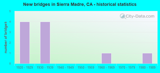
- New bridges - historical statistics
- 41920-1929
- 41930-1939
- 11960-1969
- 11980-1989

- Bridge Condition - Deck
- 50.0%Good
- 20.0%Satisfactory
- 20.0%Fair
- 10.0%Poor

- Bridge Condition - Superstructure
- 50.0%Good
- 20.0%Satisfactory
- 30.0%Fair

- Bridge Condition - Substructure
- 10.0%Very good
- 60.0%Good
- 10.0%Satisfactory
- 10.0%Fair
- 10.0%Serious

- Bridge Condition - Channel
- 90.0%Excellent
- 10.0%Very good
Find on map >> Show street view
Structure Number: 53C097, Location: 25FT W/O TOPANGA CYN BLVD (Lat: 34.096150, Lng: -118.601172), Route carried "on" structure: County highway , Year Built: 1936, Year Reconstructed: 1966, Status: Posted for load, Structure Length: 1.25m (4.10ft), Average Daily Traffic: 204 (year 2012), Average Future Daily Traffic: 204 (year 2041), Features Intersected: TOPANGA CYN CRK, Facility Carried by Structure: CIRCLE TRAIL
Minimum Vertical Clearance: 30.47m (99.97ft), Kilometerpoint: 0.000, Lanes on structure: 2, Owner: County Highway Agency, Approaching Roadway Width: 8.4m (27.6ft), Material/Design: Steel, Design/Construction: Stringer/Multi-beam, Number Of Spans In Main Unit: 1, Length of Maximum Span: 11.9m (39.0ft), Curb-To-Curb Width: 8.4m (27.6ft), Out-to-Out Width: 8.6m (28.2ft)
Condition: Deck: Good, Superstructure: Fair, Substructure: Serious, Channel: Excellent, Operating Rating: 10.4 metric tons, Method Used To Determine Operating Rating: Load Factor (LF), Inventory Rating: 6.2 metric tons, Method Used To Determine Inventory Rating: Load Factor (LF), Structural Evaluation: High priority of replacement, Deck Geometry: Somewhat better than minimum adequacy, Waterway Adequacy: Superior to present desirable criteria, Approach Roadway Alignment: High priority of corrective action, Bridge Posting: Required (Relationship of Operating Rating to Maximum Legal Load: > 39.9% below), Designated Inspection Frequency: Every 12 months, Inspection Date: March 2021, Bridge Improvement Cost: $246,000, Roadway Improvement Cost: $49,000, Total Project Cost: $413,000 ( Estimate for 2017), Deck Structure Type: Wood or Timber, Wearing Surface/Protective System: Wearing Surface: Bituminous
Find on map >> Show street view
Structure Number: 53C0976, Location: 0.6MI W/O SANTA ANITA AVE (Lat: 34.169931, Lng: -118.044081), Route carried "on" structure: City street LQ62, Year Built: 1934, Status: Open, Structure Length: 0.91m (2.99ft), Average Daily Traffic: 102 (year 2012), Truck Traffic: 1%, Average Future Daily Traffic: 102 (year 2041), Design Load: HS 20, Features Intersected: SIERRA MADRE WASH, Facility Carried by Structure: STURTEVANT DR
Minimum Vertical Clearance: 30.47m (99.97ft), Kilometerpoint: 0.000, Lanes on structure: 2, Owner: City or Municipal Highway Agency, Approaching Roadway Width: 5.2m (17.1ft), Skew: 1 degrees, Material/Design: Concrete, Design/Construction: Slab, Number Of Spans In Main Unit: 1, Length of Maximum Span: 7.9m (25.9ft), Curb-To-Curb Width: 5.8m (19.0ft), Out-to-Out Width: 7.1m (23.3ft)
Condition: Deck: Good, Superstructure: Good, Substructure: Fair, Channel: Very good, Operating Rating: 28.8 metric tons, Method Used To Determine Operating Rating: Load Factor (LF), Inventory Rating: 17.2 metric tons, Method Used To Determine Inventory Rating: Load Factor (LF), Structural Evaluation: Somewhat better than minimum adequacy, Deck Geometry: High priority of corrective action, Waterway Adequacy: Better than present minimum criteria, Approach Roadway Alignment: Better than present minimum criteria, Designated Inspection Frequency: Every 24 months, Inspection Date: May 2021, Deck Structure Type: Concrete Cast-file-Place, Wearing Surface/Protective System: Wearing Surface: Bituminous
Find on map >> Show street view
Structure Number: 53C103, Location: 0.1MI E/O AZUSA AVE (Lat: 34.118422, Lng: -117.906617), Route carried "on" structure: City street , Year Built: 1960, Status: Open, Structure Length: 0.91m (2.99ft), Average Daily Traffic: 153 (year 2012), Truck Traffic: 2%, Average Future Daily Traffic: 153 (year 2040), Features Intersected: LITTLE DALTON WASH, Facility Carried by Structure: AZUSA LN
Minimum Vertical Clearance: 30.47m (99.97ft), Kilometerpoint: 0.000, Lanes on structure: 1, Owner: City or Municipal Highway Agency, Approaching Roadway Width: 8.2m (26.9ft), Skew: 2 degrees, Material/Design: Concrete, Design/Construction: Slab, Number Of Spans In Main Unit: 1, Length of Maximum Span: 8.7m (28.5ft), Curb or Sidewalk Widths: Left: 0.6m (2.0ft), Right: 0.6m (2.0ft), Curb-To-Curb Width: 3.7m (12.1ft), Out-to-Out Width: 5.2m (17.1ft)
Condition: Deck: Satisfactory, Superstructure: Satisfactory, Substructure: Very good, Channel: Excellent, Operating Rating: 42.8 metric tons, Method Used To Determine Operating Rating: Load Factor (LF), Inventory Rating: 25.6 metric tons, Method Used To Determine Inventory Rating: Load Factor (LF), Structural Evaluation: Equal to present minimum criteria, Deck Geometry: High priority of replacement, Waterway Adequacy: Superior to present desirable criteria, Approach Roadway Alignment: Somewhat better than minimum adequacy, Designated Inspection Frequency: Every 24 months, Inspection Date: April 2020, Deck Structure Type: Concrete Cast-file-Place
Find on map >> Show street view
Structure Number: 53C1033, Location: 0.5MI W/O SANTA ANITA AVE (Lat: 34.168375, Lng: -118.041011), Route carried "on" structure: City street , Year Built: 1928, Status: Posted for load, Structure Length: 1.19m (3.90ft), Average Daily Traffic: 155 (year 2012), Truck Traffic: 2%, Average Future Daily Traffic: 155 (year 2041), Design Load: H 15, Features Intersected: SIERRA MADRE WASH, Facility Carried by Structure: CAMILLO ST
Minimum Vertical Clearance: 30.47m (99.97ft), Kilometerpoint: 0.000, Lanes on structure: 2, Owner: City or Municipal Highway Agency, Approaching Roadway Width: 9.1m (29.9ft), Skew: 4 degrees, Material/Design: Concrete, Design/Construction: Tee Beam, Number Of Spans In Main Unit: 1, Length of Maximum Span: 11.0m (36.1ft), Curb-To-Curb Width: 9.3m (30.5ft), Out-to-Out Width: 10.2m (33.5ft)
Condition: Deck: Good, Superstructure: Fair, Substructure: Good, Channel: Excellent, Operating Rating: 26.6 metric tons, Method Used To Determine Operating Rating: Load Factor (LF), Inventory Rating: 15.9 metric tons, Method Used To Determine Inventory Rating: Load Factor (LF), Structural Evaluation: Meets minimum limits, Deck Geometry: Equal to present minimum criteria, Waterway Adequacy: Superior to present desirable criteria, Approach Roadway Alignment: Equal to present desirable criteria, Bridge Posting: Required (Relationship of Operating Rating to Maximum Legal Load: 10.0 - 19.9% below), Designated Inspection Frequency: Every 12 months, Inspection Date: May 2021, Deck Structure Type: Concrete Cast-file-Place, Wearing Surface/Protective System: Wearing Surface: Bituminous
Find on map >> Show street view
Structure Number: 53C1034, Location: 1.5MI N/O I-10 FWY (Lat: 34.171083, Lng: -118.043594), Route carried "on" structure: City street LQ63, Year Built: 1928, Status: Posted for load, Structure Length: 0.98m (3.22ft), Average Daily Traffic: 116 (year 2012), Truck Traffic: 2%, Average Future Daily Traffic: 116 (year 2040), Features Intersected: SIERRA MADRE WASH, Facility Carried by Structure: WOODLAND DR
Minimum Vertical Clearance: 30.47m (99.97ft), Kilometerpoint: 0.000, Lanes on structure: 2, Owner: City or Municipal Highway Agency, Approaching Roadway Width: 5.5m (18.0ft), Skew: 4 degrees, Material/Design: Concrete, Design/Construction: Stringer/Multi-beam, Number Of Spans In Main Unit: 1, Length of Maximum Span: 9.1m (29.9ft), Curb-To-Curb Width: 5.5m (18.0ft), Out-to-Out Width: 7.0m (23.0ft)
Condition: Deck: Satisfactory, Superstructure: Satisfactory, Substructure: Good, Channel: Excellent, Operating Rating: 30.8 metric tons, Method Used To Determine Operating Rating: Load Factor (LF), Inventory Rating: 18.5 metric tons, Method Used To Determine Inventory Rating: Load Factor (LF), Structural Evaluation: Somewhat better than minimum adequacy, Deck Geometry: High priority of corrective action, Waterway Adequacy: Superior to present desirable criteria, Approach Roadway Alignment: Equal to present desirable criteria, Bridge Posting: Required (Relationship of Operating Rating to Maximum Legal Load: 10.0 - 19.9% below), Designated Inspection Frequency: Every 12 months, Inspection Date: May 2021, Deck Structure Type: Concrete Cast-file-Place, Wearing Surface/Protective System: Wearing Surface: Bituminous
Find on map >> Show street view
Structure Number: 53C1035, Location: 1.8MI N/O I-10 FWY (Lat: 34.174975, Lng: -118.043231), Route carried "on" structure: City street LQ63, Year Built: 1987, Status: Open, Structure Length: 0.98m (3.22ft), Average Daily Traffic: 51 (year 2012), Truck Traffic: 1%, Average Future Daily Traffic: 51 (year 2041), Design Load: HS 20, Features Intersected: SIERRA MADRE WASH, Facility Carried by Structure: WOODLAND DR
Minimum Vertical Clearance: 30+ m (98+ ft), Kilometerpoint: 0.000, Lanes on structure: 2, Owner: City or Municipal Highway Agency, Approaching Roadway Width: 5.2m (17.1ft), Skew: 5 degrees, Material/Design: Concrete, Design/Construction: Slab, Number Of Spans In Main Unit: 1, Length of Maximum Span: 5.5m (18.0ft), Curb-To-Curb Width: 7.8m (25.6ft), Out-to-Out Width: 8.4m (27.6ft)
Condition: Deck: Good, Superstructure: Good, Substructure: Good, Channel: Excellent, Operating Rating: 87.2 metric tons, Method Used To Determine Operating Rating: Load Factor (LF), Inventory Rating: 52.2 metric tons, Method Used To Determine Inventory Rating: Load Factor (LF), Structural Evaluation: Better than present minimum criteria, Deck Geometry: Equal to present minimum criteria, Waterway Adequacy: Superior to present desirable criteria, Approach Roadway Alignment: Equal to present minimum criteria, Designated Inspection Frequency: Every 48 months, Inspection Date: May 2021, Deck Structure Type: Concrete Cast-file-Place, Wearing Surface/Protective System: Wearing Surface: Monolithic Concrete
Find on map >> Show street view
Structure Number: 53C1036, Location: 0.5MI W/O SANTA ANITA AVE (Lat: 34.167997, Lng: -118.040072), Route carried "on" structure: City street , Year Built: 1939, Status: Posted for load, Structure Length: 0.85m (2.79ft), Average Daily Traffic: 232 (year 2012), Truck Traffic: 2%, Average Future Daily Traffic: 232 (year 2041), Features Intersected: SIERRA MADRE WASH, Facility Carried by Structure: ACACIA ST
Minimum Vertical Clearance: 30.47m (99.97ft), Kilometerpoint: 0.000, Lanes on structure: 2, Owner: City or Municipal Highway Agency, Approaching Roadway Width: 9.1m (29.9ft), Material/Design: Concrete, Design/Construction: Tee Beam, Number Of Spans In Main Unit: 1, Length of Maximum Span: 7.6m (24.9ft), Curb or Sidewalk Widths: Left: 2.5m (8.2ft), Right: 2.5m (8.2ft), Curb-To-Curb Width: 9.1m (29.9ft), Out-to-Out Width: 14.7m (48.2ft)
Condition: Deck: Good, Superstructure: Good, Substructure: Satisfactory, Channel: Excellent, Operating Rating: 24.3 metric tons, Method Used To Determine Operating Rating: Load Factor (LF), Inventory Rating: 14.6 metric tons, Method Used To Determine Inventory Rating: Load Factor (LF), Structural Evaluation: Meets minimum limits, Deck Geometry: Equal to present minimum criteria, Waterway Adequacy: Superior to present desirable criteria, Approach Roadway Alignment: Equal to present desirable criteria, Bridge Posting: Required (Relationship of Operating Rating to Maximum Legal Load: 0.1 - 9.9% below), Designated Inspection Frequency: Every 12 months, Inspection Date: May 2021, Deck Structure Type: Concrete Cast-file-Place, Wearing Surface/Protective System: Wearing Surface: Monolithic Concrete
Find on map >> Show street view
Structure Number: 53C1037, Location: 0.6MI W/O SANTA ANITA AVE (Lat: 34.169483, Lng: -118.043436), Route carried "on" structure: City street , Year Built: 1928, Status: Posted for load, Structure Length: 0.85m (2.79ft), Average Daily Traffic: 378 (year 2012), Truck Traffic: 2%, Average Future Daily Traffic: 378 (year 2041), Features Intersected: SIERRA MADRE WASH, Facility Carried by Structure: LAS ROCAS DR
Minimum Vertical Clearance: 30.47m (99.97ft), Kilometerpoint: 0.000, Lanes on structure: 2, Owner: City or Municipal Highway Agency, Approaching Roadway Width: 5.5m (18.0ft), Material/Design: Concrete, Design/Construction: Tee Beam, Number Of Spans In Main Unit: 1, Length of Maximum Span: 7.6m (24.9ft), Curb-To-Curb Width: 6.1m (20.0ft), Out-to-Out Width: 7.0m (23.0ft)
Condition: Deck: Fair, Superstructure: Fair, Substructure: Good, Channel: Excellent, Operating Rating: 30.8 metric tons, Method Used To Determine Operating Rating: Load Factor (LF), Inventory Rating: 18.5 metric tons, Method Used To Determine Inventory Rating: Load Factor (LF), Structural Evaluation: Somewhat better than minimum adequacy, Deck Geometry: Meets minimum limits, Waterway Adequacy: Superior to present desirable criteria, Approach Roadway Alignment: Equal to present desirable criteria, Bridge Posting: Required (Relationship of Operating Rating to Maximum Legal Load: 0.1 - 9.9% below), Designated Inspection Frequency: Every 12 months, Inspection Date: May 2021, Deck Structure Type: Concrete Cast-file-Place, Wearing Surface/Protective System: Wearing Surface: Monolithic Concrete
Find on map >> Show street view
Structure Number: 53C1038, Location: 0.6MI W/O SANTA ANITA AVE (Lat: 34.168942, Lng: -118.042317), Route carried "on" structure: City street , Year Built: 1928, Status: Posted for load, Structure Length: 0.82m (2.69ft), Average Daily Traffic: 408 (year 2012), Truck Traffic: 2%, Average Future Daily Traffic: 408 (year 2041), Features Intersected: SIERRA MADRE WASH, Facility Carried by Structure: SYCAMORE PL
Minimum Vertical Clearance: 30.47m (99.97ft), Kilometerpoint: 0.000, Lanes on structure: 2, Owner: City or Municipal Highway Agency, Approaching Roadway Width: 5.5m (18.0ft), Skew: 1 degrees, Material/Design: Concrete, Design/Construction: Tee Beam, Number Of Spans In Main Unit: 1, Length of Maximum Span: 7.3m (24.0ft), Curb-To-Curb Width: 6.2m (20.3ft), Out-to-Out Width: 6.8m (22.3ft)
Condition: Deck: Poor, Superstructure: Good, Substructure: Good, Channel: Excellent, Operating Rating: 31.4 metric tons, Method Used To Determine Operating Rating: Load Factor (LF), Inventory Rating: 18.8 metric tons, Method Used To Determine Inventory Rating: Load Factor (LF), Structural Evaluation: Somewhat better than minimum adequacy, Deck Geometry: High priority of corrective action, Waterway Adequacy: Superior to present desirable criteria, Approach Roadway Alignment: Equal to present desirable criteria, Bridge Posting: Required (Relationship of Operating Rating to Maximum Legal Load: 0.1 - 9.9% below), Designated Inspection Frequency: Every 12 months, Inspection Date: May 2021, Bridge Improvement Cost: $128,000, Roadway Improvement Cost: $25,000, Total Project Cost: $215,000 ( Estimate for 2017), Deck Structure Type: Concrete Cast-file-Place, Wearing Surface/Protective System: Wearing Surface: Monolithic Concrete
Find on map >> Show street view
Structure Number: 53C1039, Location: 0.4MI W/O SANTA ANITA AVE (Lat: 34.166833, Lng: -118.038419), Route carried "on" structure: City street M805, Year Built: 1939, Status: Open, Structure Length: 1.10m (3.61ft), Average Daily Traffic: 1,428 (year 2012), Truck Traffic: 2%, Average Future Daily Traffic: 1,571 (year 2041), Features Intersected: SIERRA MADRE WASH, Facility Carried by Structure: GRAND VIEW AVE
Minimum Vertical Clearance: 30+ m (98+ ft), Kilometerpoint: 0.000, Lanes on structure: 2, Owner: City or Municipal Highway Agency, Approaching Roadway Width: 12.2m (40.0ft), Skew: 2 degrees, Material/Design: Concrete, Design/Construction: Tee Beam, Number Of Spans In Main Unit: 1, Length of Maximum Span: 9.8m (32.2ft), Curb or Sidewalk Widths: Left: 1.5m (4.9ft), Right: 0.5m (1.6ft), Curb-To-Curb Width: 11.9m (39.0ft), Out-to-Out Width: 14.0m (45.9ft)
Condition: Deck: Fair, Superstructure: Good, Substructure: Good, Channel: Excellent, Operating Rating: 55.1 metric tons, Method Used To Determine Operating Rating: Load Factor (LF), Inventory Rating: 33.0 metric tons, Method Used To Determine Inventory Rating: Load Factor (LF), Structural Evaluation: Better than present minimum criteria, Deck Geometry: Equal to present minimum criteria, Waterway Adequacy: Superior to present desirable criteria, Approach Roadway Alignment: Equal to present desirable criteria, Designated Inspection Frequency: Every 24 months, Inspection Date: May 2021, Deck Structure Type: Concrete Cast-file-Place, Wearing Surface/Protective System: Wearing Surface: Monolithic Concrete