Bridge Statistics for Somerville, Texas (TX)
Condition, Traffic, Stress, Structural Evaluation, Project Costs
- National Bridge Inventory (NBI) Statistics
- 12Number of bridges
- 171ft / 52.4mTotal length
- 38,242Total average daily traffic
- 6,048Total average daily truck traffic
- 62,890Total future (year 2028) average daily traffic
- National Bridge Inventory (NBI) Registered Bridges for Somerville
- No street view available for this location
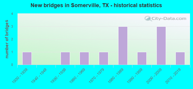
- New bridges - historical statistics
- 11930-1939
- 11950-1959
- 11960-1969
- 11970-1979
- 31980-1989
- 11990-1999
- 32000-2009
- 12010-2019

- Reconstructed bridges - Historical Statistics
- 11970-1979
- 01980-1989
- 11990-1999
- 12000-2009


- Bridge Condition - Deck
- 22.2%Very good
- 66.7%Good
- 11.1%Satisfactory

- Bridge Condition - Superstructure
- 22.2%Very good
- 66.7%Good
- 11.1%Satisfactory

- Bridge Condition - Substructure
- 22.2%Very good
- 22.2%Good
- 55.6%Satisfactory

- Bridge Condition - Channel
- 8.3%Very good
- 33.3%Good
- 58.3%Satisfactory

- Bridge Condition - Culverts
- 66.7%Good
- 33.3%Satisfactory
Find on map >> Show street view
Structure Number: 17026001860304, Location: 0.3 MI N OF FM 1361 (Lat: 30.350322, Lng: -96.532617), Route carried "on" structure: State highway 36, Year Built: 1937, Year Reconstructed: 2000, Status: Open, Structure Length: 0.79m (2.59ft), Average Daily Traffic: 9,960 (year 2013), Truck Traffic: 22%, Average Future Daily Traffic: 13,950 (year 2033), Design Load: H 15, Features Intersected: THOMPSON CREEK
Minimum Vertical Clearance: 30+ m (98+ ft), Kilometerpoint: 27.282, Lanes on structure: 5, Owner: State Highway Agency, Approaching Roadway Width: 20.1m (65.9ft), Material/Design: Concrete, Design/Construction: Culvert, Number Of Spans In Main Unit: 3, Length of Maximum Span: 2.4m (7.9ft), Curb-To-Curb Width: 20.1m (65.9ft), Out-to-Out Width: 29.2m (95.8ft)
Condition: Channel: Good, Culverts: Good, Operating Rating: 39.9 metric tons, Method Used To Determine Operating Rating: Load Factor (LF), Inventory Rating: 23.6 metric tons, Method Used To Determine Inventory Rating: Load Factor (LF), Structural Evaluation: Somewhat better than minimum adequacy, Deck Geometry: Somewhat better than minimum adequacy, Waterway Adequacy: Equal to present minimum criteria, Approach Roadway Alignment: Equal to present desirable criteria, Designated Inspection Frequency: Every 24 months, Inspection Date: August 2020, Deck Structure Type: Concrete Cast-file-Place, Wearing Surface/Protective System: Wearing Surface: Bituminous
Find on map >> Show street view
Structure Number: 170260018604051, Location: AT THE WASHINGTON C/L (Lat: 30.321725, Lng: -96.507622), Route carried "on" structure: State highway 36, Year Built: 1971, Year Reconstructed: 1995, Status: Open, Structure Length: 12.80m (41.99ft), Average Daily Traffic: 10,420 (year 2013), Truck Traffic: 15%, Average Future Daily Traffic: 14,600 (year 2033), Design Load: HS 20, Features Intersected: YEGUA CREEK
Minimum Vertical Clearance: 30+ m (98+ ft), Kilometerpoint: 3.275, Lanes on structure: 5, Owner: State Highway Agency, Approaching Roadway Width: 25.3m (83.0ft), Material/Design: Prestressed concrete, Design/Construction: Stringer/Multi-beam, Number Of Spans In Main Unit: 6, Length of Maximum Span: 21.3m (69.9ft), Curb-To-Curb Width: 25.4m (83.3ft), Out-to-Out Width: 26.3m (86.3ft)
Condition: Deck: Good, Superstructure: Good, Substructure: Good, Channel: Good, Operating Rating: 44.4 metric tons, Method Used To Determine Operating Rating: Assigned ratings based on Allowable Stress Design (ASD) reported in metric tons, Inventory Rating: 32.7 metric tons, Method Used To Determine Inventory Rating: Assigned ratings based on Allowable Stress Design (ASD) reported in metric tons, Structural Evaluation: Better than present minimum criteria, Deck Geometry: Superior to present desirable criteria, Waterway Adequacy: Superior to present desirable criteria, Approach Roadway Alignment: Equal to present desirable criteria, Designated Inspection Frequency: Every 24 months, Inspection Date: August 2020, Deck Structure Type: Concrete Cast-file-Place, Wearing Surface/Protective System: Wearing Surface: Bituminous
Find on map >> Show street view
Structure Number: 170260064803012, Location: 3.0 MI E OF SH 36 (Lat: 30.415931, Lng: -96.542814), Route carried "on" structure: State highway 60, Year Built: 1951, Year Reconstructed: 1970, Status: Open, Structure Length: 4.57m (14.99ft), Average Daily Traffic: 5,335 (year 2020), Average Future Daily Traffic: 5,880 (year 2031), Design Load: H 15, Features Intersected: DAVIDSON CREEK RELIEF
Minimum Vertical Clearance: 30+ m (98+ ft), Kilometerpoint: 4.168, Lanes on structure: 2, Owner: State Highway Agency, Approaching Roadway Width: 7.9m (25.9ft), Material/Design: Concrete, Design/Construction: Stringer/Multi-beam, Number Of Spans In Main Unit: 5, Length of Maximum Span: 9.1m (29.9ft), Curb-To-Curb Width: 14.6m (47.9ft), Out-to-Out Width: 15.4m (50.5ft)
Condition: Deck: Good, Superstructure: Good, Substructure: Satisfactory, Channel: Satisfactory, Operating Rating: 45.4 metric tons, Method Used To Determine Operating Rating: Load Factor (LF), Inventory Rating: 26.3 metric tons, Method Used To Determine Inventory Rating: Load Factor (LF), Structural Evaluation: Equal to present minimum criteria, Deck Geometry: Superior to present desirable criteria, Waterway Adequacy: Equal to present minimum criteria, Approach Roadway Alignment: Equal to present desirable criteria, Designated Inspection Frequency: Every 24 months, Inspection Date: August 2020, Deck Structure Type: Concrete Cast-file-Place, Wearing Surface/Protective System: Wearing Surface: Bituminous
Find on map >> Show street view
Structure Number: 170260139901005, Location: 0.6 MI NE OF SH 36 (Lat: 30.351631, Lng: -96.520422), Route carried "on" structure: State highway 1361, Year Built: 1987, Status: Open, Structure Length: 1.86m (6.10ft), Average Daily Traffic: 701 (year 2020), Truck Traffic: 13%, Average Future Daily Traffic: 1,230 (year 2033), Design Load: HS 20, Features Intersected: THOMPSON CREEK
Minimum Vertical Clearance: 30+ m (98+ ft), Kilometerpoint: 2.570, Lanes on structure: 2, Owner: State Highway Agency, Approaching Roadway Width: 7.3m (24.0ft), Material/Design: Concrete, Design/Construction: Stringer/Multi-beam, Number Of Spans In Main Unit: 2, Length of Maximum Span: 9.1m (29.9ft), Curb-To-Curb Width: 10.5m (34.4ft), Out-to-Out Width: 11.1m (36.4ft)
Condition: Deck: Good, Superstructure: Good, Substructure: Satisfactory, Channel: Satisfactory, Operating Rating: 60.8 metric tons, Method Used To Determine Operating Rating: Load Factor (LF), Inventory Rating: 36.3 metric tons, Method Used To Determine Inventory Rating: Load Factor (LF), Structural Evaluation: Equal to present minimum criteria, Deck Geometry: Equal to present minimum criteria, Waterway Adequacy: Equal to present minimum criteria, Approach Roadway Alignment: Equal to present desirable criteria, Designated Inspection Frequency: Every 24 months, Inspection Date: August 2020, Deck Structure Type: Concrete Cast-file-Place
Find on map >> Show street view
Structure Number: 170260139901006, Location: 3.3 MI NE OF SH 36 (Lat: 30.374075, Lng: -96.485106), Route carried "on" structure: State highway 1361, Year Built: 1987, Status: Open, Structure Length: 4.63m (15.19ft), Average Daily Traffic: 701 (year 2020), Truck Traffic: 13%, Average Future Daily Traffic: 1,230 (year 2033), Design Load: HS 20, Features Intersected: DAVIDSON CREEK RELIEF
Minimum Vertical Clearance: 30+ m (98+ ft), Kilometerpoint: 6.922, Lanes on structure: 2, Owner: State Highway Agency, Approaching Roadway Width: 10.4m (34.1ft), Material/Design: Concrete, Design/Construction: Stringer/Multi-beam, Number Of Spans In Main Unit: 5, Length of Maximum Span: 9.1m (29.9ft), Curb-To-Curb Width: 10.5m (34.4ft), Out-to-Out Width: 11.1m (36.4ft)
Condition: Deck: Good, Superstructure: Good, Substructure: Satisfactory, Channel: Satisfactory, Operating Rating: 59.9 metric tons, Method Used To Determine Operating Rating: Load Factor (LF), Inventory Rating: 36.3 metric tons, Method Used To Determine Inventory Rating: Load Factor (LF), Structural Evaluation: Equal to present minimum criteria, Deck Geometry: Equal to present minimum criteria, Waterway Adequacy: Equal to present minimum criteria, Approach Roadway Alignment: Equal to present desirable criteria, Designated Inspection Frequency: Every 24 months, Inspection Date: August 2020, Deck Structure Type: Concrete Cast-file-Place
Find on map >> Show street view
Structure Number: 170260139901007, Location: 3.5 MI NE OF SH 36 (Lat: 30.374578, Lng: -96.483761), Route carried "on" structure: State highway 1361, Year Built: 1987, Status: Open, Structure Length: 12.95m (42.49ft), Average Daily Traffic: 701 (year 2020), Truck Traffic: 13%, Average Future Daily Traffic: 1,230 (year 2033), Design Load: HS 20, Features Intersected: DAVIDSON CREEK
Minimum Vertical Clearance: 30+ m (98+ ft), Kilometerpoint: 7.038, Lanes on structure: 2, Owner: State Highway Agency, Approaching Roadway Width: 10.4m (34.1ft), Material/Design: Concrete, Design/Construction: Stringer/Multi-beam, Number Of Spans In Main Unit: 14, Length of Maximum Span: 9.1m (29.9ft), Curb-To-Curb Width: 10.5m (34.4ft), Out-to-Out Width: 11.1m (36.4ft)
Condition: Deck: Satisfactory, Superstructure: Good, Substructure: Satisfactory, Channel: Satisfactory, Operating Rating: 59.9 metric tons, Method Used To Determine Operating Rating: Load Factor (LF), Inventory Rating: 36.3 metric tons, Method Used To Determine Inventory Rating: Load Factor (LF), Structural Evaluation: Equal to present minimum criteria, Deck Geometry: Equal to present minimum criteria, Waterway Adequacy: Equal to present minimum criteria, Approach Roadway Alignment: Equal to present desirable criteria, Designated Inspection Frequency: Every 24 months, Inspection Date: August 2020, Deck Structure Type: Concrete Cast-file-Place
Find on map >> Show street view
Structure Number: 170260AA0317006, Location: 3.47 MI E OF SH 36 (Lat: 30.395481, Lng: -96.503094), Route carried "on" structure: County highway 201, Year Built: 2008, Status: Open, Structure Length: 1.19m (3.90ft), Average Daily Traffic: 120 (year 2010), Average Future Daily Traffic: 140 (year 2028), Design Load: HS 20, Features Intersected: DAVIDSON CREEK RELIEF
Minimum Vertical Clearance: 30+ m (98+ ft), Kilometerpoint: 5.472, Lanes on structure: 2, Owner: County Highway Agency, Approaching Roadway Width: 7.3m (24.0ft), Material/Design: Concrete, Design/Construction: Culvert, Number Of Spans In Main Unit: 4, Length of Maximum Span: 2.4m (7.9ft), Curb-To-Curb Width: 7.3m (24.0ft), Out-to-Out Width: 7.9m (25.9ft)
Condition: Channel: Good, Culverts: Good, Operating Rating: 54.4 metric tons, Method Used To Determine Operating Rating: Assigned ratings based on Load and Resistance Factor Design (LRFD) reported in metric tons, Inventory Rating: 32.7 metric tons, Method Used To Determine Inventory Rating: Assigned ratings based on Load and Resistance Factor Design (LRFD) reported in metric tons, Structural Evaluation: Better than present minimum criteria, Deck Geometry: Somewhat better than minimum adequacy, Waterway Adequacy: Equal to present minimum criteria, Approach Roadway Alignment: Equal to present desirable criteria, Designated Inspection Frequency: Every 24 months, Inspection Date: Febuary 2020, Deck Structure Type: Concrete Cast-file-Place, Wearing Surface/Protective System: Wearing Surface: Bituminous
Find on map >> Show street view
Structure Number: 170260AA0317007, Location: 3.4 MI E OF SH 36 (Lat: 30.394894, Lng: -96.503703), Route carried "on" structure: County highway 423, Year Built: 2008, Status: Open, Structure Length: 1.83m (6.00ft), Average Daily Traffic: 120 (year 2010), Average Future Daily Traffic: 140 (year 2028), Design Load: HL 93, Features Intersected: DAVIDSON CREEK
Minimum Vertical Clearance: 30+ m (98+ ft), Kilometerpoint: 5.311, Lanes on structure: 2, Owner: County Highway Agency, Approaching Roadway Width: 7.3m (24.0ft), Skew: 1 degrees, Material/Design: Prestressed concrete, Design/Construction: Box Beam or Girders - Multiple, Number Of Spans In Main Unit: 2, Length of Maximum Span: 10.7m (35.1ft), Curb-To-Curb Width: 7.3m (24.0ft), Out-to-Out Width: 7.9m (25.9ft)
Condition: Deck: Good, Superstructure: Very good, Substructure: Very good, Channel: Satisfactory, Operating Rating: 54.4 metric tons, Method Used To Determine Operating Rating: Assigned ratings based on Load and Resistance Factor Design (LRFD) reported in metric tons, Inventory Rating: 32.7 metric tons, Method Used To Determine Inventory Rating: Assigned ratings based on Load and Resistance Factor Design (LRFD) reported in metric tons, Structural Evaluation: Equal to present desirable criteria, Deck Geometry: Somewhat better than minimum adequacy, Waterway Adequacy: Equal to present minimum criteria, Approach Roadway Alignment: Equal to present desirable criteria, Designated Inspection Frequency: Every 24 months, Inspection Date: Febuary 2020, Deck Structure Type: Concrete Cast-file-Place
Find on map >> Show street view
Structure Number: 172390018605054, Location: 1.81 MI NW OF FM 390 (Lat: 30.294075, Lng: -96.499872), Route carried "on" structure: State highway 36, Year Built: 1995, Status: Open, Structure Length: 4.27m (14.01ft), Average Daily Traffic: 4,883 (year 2020), Truck Traffic: 19%, Average Future Daily Traffic: 11,700 (year 2040), Design Load: HS 20, Features Intersected: WOLF CREEK
Minimum Vertical Clearance: 30+ m (98+ ft), Kilometerpoint: 3.442, Lanes on structure: 2, Base Highway Network: Yes, Owner: State Highway Agency, Approaching Roadway Width: 13.1m (43.0ft), Material/Design: Prestressed concrete, Design/Construction: Stringer/Multi-beam, Number Of Spans In Main Unit: 1, Number Of Approach Spans: 2, Length of Maximum Span: 18.3m (60.0ft), Curb-To-Curb Width: 13.1m (43.0ft), Out-to-Out Width: 13.5m (44.3ft)
Condition: Deck: Very good, Superstructure: Good, Substructure: Good, Channel: Good, Operating Rating: 54.4 metric tons, Method Used To Determine Operating Rating: Assigned rating based on Load Factor Design (LFD) reported in metric tons, Inventory Rating: 32.7 metric tons, Method Used To Determine Inventory Rating: Assigned rating based on Load Factor Design (LFD) reported in metric tons, Structural Evaluation: Better than present minimum criteria, Deck Geometry: Superior to present desirable criteria, Waterway Adequacy: Better than present minimum criteria, Approach Roadway Alignment: Equal to present desirable criteria, Designated Inspection Frequency: Every 24 months, Inspection Date: April 2021, Deck Structure Type: Concrete Precast Panels, Wearing Surface/Protective System: Wearing Surface: Bituminous
Find on map >> Show street view
Structure Number: 172390018605193, Location: 1.81 MI NW OF FM 390 (Lat: 30.293967, Lng: -96.499400), Route carried "on" structure: State highway 36, Year Built: 2018, Status: Open, Structure Length: 4.69m (15.39ft), Average Daily Traffic: 4,776 (year 2020), Truck Traffic: 22%, Average Future Daily Traffic: 11,700 (year 2040), Design Load: HL 93, Features Intersected: WOLF CREEK
Minimum Vertical Clearance: 30+ m (98+ ft), Kilometerpoint: 3.442, Lanes on structure: 2, Base Highway Network: Yes, Owner: State Highway Agency, Approaching Roadway Width: 12.4m (40.7ft), Material/Design: Prestressed concrete, Design/Construction: Stringer/Multi-beam, Number Of Spans In Main Unit: 1, Number Of Approach Spans: 2, Length of Maximum Span: 22.6m (74.1ft), Curb-To-Curb Width: 12.4m (40.7ft), Out-to-Out Width: 12.8m (42.0ft)
Condition: Deck: Very good, Superstructure: Very good, Substructure: Very good, Channel: Very good, Operating Rating: 54.4 metric tons, Method Used To Determine Operating Rating: Assigned ratings based on Load and Resistance Factor Design (LRFD) reported in metric tons, Inventory Rating: 32.7 metric tons, Method Used To Determine Inventory Rating: Assigned ratings based on Load and Resistance Factor Design (LRFD) reported in metric tons, Structural Evaluation: Equal to present desirable criteria, Deck Geometry: Better than present minimum criteria, Waterway Adequacy: Better than present minimum criteria, Approach Roadway Alignment: Equal to present desirable criteria, Designated Inspection Frequency: Every 24 months, Inspection Date: April 2021, Deck Structure Type: Concrete Cast-file-Place, Wearing Surface/Protective System: Wearing Surface: Bituminous
Find on map >> Show street view
Structure Number: 172390223802001, Location: 3.47 MI W OF SH 36 (Lat: 30.289497, Lng: -96.546158), Route carried "on" structure: State highway 1948, Year Built: 1969, Status: Open, Structure Length: 0.64m (2.10ft), Average Daily Traffic: 495 (year 2020), Truck Traffic: 9%, Average Future Daily Traffic: 1,010 (year 2033), Design Load: HS 20, Features Intersected: SANDY BRANCH
Minimum Vertical Clearance: 30+ m (98+ ft), Kilometerpoint: 5.589, Lanes on structure: 2, Owner: State Highway Agency, Approaching Roadway Width: 7.3m (24.0ft), Material/Design: Concrete, Design/Construction: Culvert, Number Of Spans In Main Unit: 2, Length of Maximum Span: 3.0m (9.8ft)
Condition: Channel: Satisfactory, Culverts: Satisfactory, Operating Rating: 39.9 metric tons, Method Used To Determine Operating Rating: Load Factor (LF), Inventory Rating: 23.6 metric tons, Method Used To Determine Inventory Rating: Load Factor (LF), Structural Evaluation: Equal to present minimum criteria, Waterway Adequacy: Equal to present minimum criteria, Approach Roadway Alignment: Equal to present desirable criteria, Designated Inspection Frequency: Every 24 months, Inspection Date: April 2021
Find on map >> Show street view
Structure Number: 172390AA0247001, Location: 1.9 MI NW OF SH 36 (Lat: 30.306650, Lng: -96.487219), Route carried "on" structure: County highway , Year Built: 2003, Status: Open, Structure Length: 2.13m (6.99ft), Average Daily Traffic: 30 (year 2015), Average Future Daily Traffic: 80 (year 2035), Features Intersected: WOLF CREEK, Facility Carried by Structure: QUARRY RD
Minimum Vertical Clearance: 30+ m (98+ ft), Kilometerpoint: 3.058, Lanes on structure: 2, Owner: County Highway Agency, Approaching Roadway Width: 5.5m (18.0ft), Material/Design: Steel, Design/Construction: Stringer/Multi-beam, Number Of Spans In Main Unit: 1, Number Of Approach Spans: 2, Length of Maximum Span: 12.2m (40.0ft), Curb-To-Curb Width: 5.9m (19.4ft), Out-to-Out Width: 6.1m (20.0ft)
Condition: Deck: Good, Superstructure: Satisfactory, Substructure: Satisfactory, Channel: Satisfactory, Operating Rating: 68.0 metric tons, Method Used To Determine Operating Rating: Load Factor (LF), Inventory Rating: 40.8 metric tons, Method Used To Determine Inventory Rating: Load Factor (LF), Structural Evaluation: Equal to present minimum criteria, Deck Geometry: Meets minimum limits, Waterway Adequacy: Better than present minimum criteria, Approach Roadway Alignment: Equal to present minimum criteria, Designated Inspection Frequency: Every 24 months, Inspection Date: December 2021, Deck Structure Type: Concrete Cast-file-Place